Tuesday January 13
We are once again back to mild afternoons with sunshine, but that is about to change. The next cold front will usher in a series of arctic air masses, returning us to the cold winter we experienced at the beginning.
With the cold front on Wednesday, rain will change to a brief period of snow overnight. The snow may last for an hour or two in most areas. This may drop a coating of snow or more, then end before sunrise on Thursday.
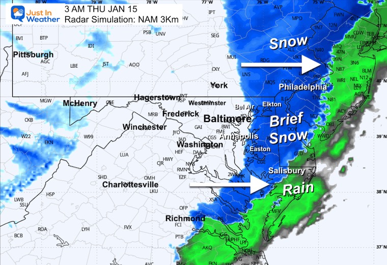
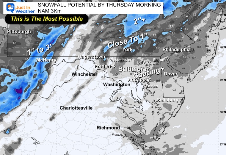
A little more snow may fall north of Baltimore and also on Delmarva. But the sun and wind on Thursday will dismiss that quickly.
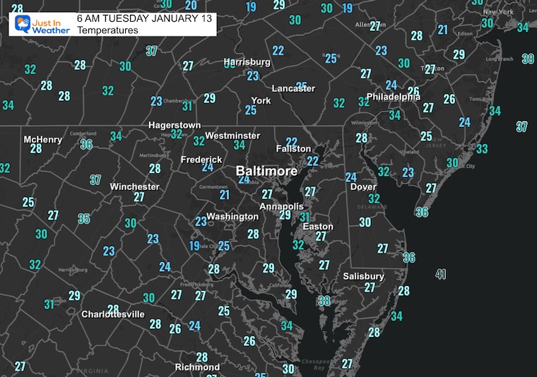
Morning Temperatures
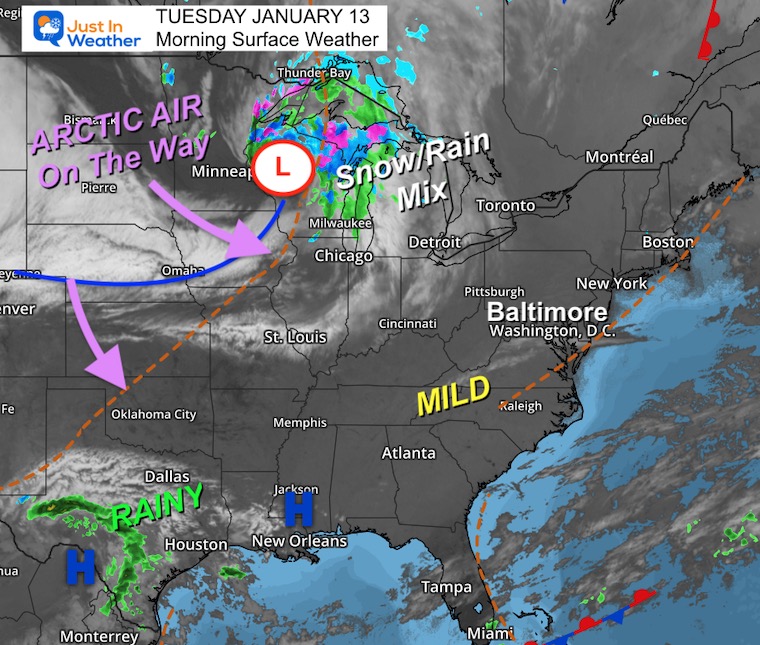
Morning Surface Weather
For Baltimore and the Mid-Atlantic: Mild conditions continue today as we sit on the warm side of the front. Enjoy it while it lasts — big changes are coming!
- Snow/Rain Mix: A low-pressure system over the Upper Midwest is producing a snow and rain mix from Minnesota through Wisconsin and Michigan.
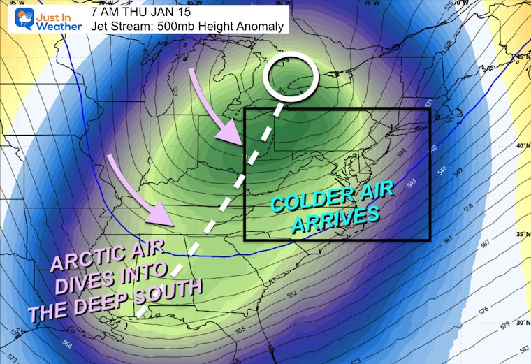
- Arctic Air On The Way: The main story — a surge of arctic air is diving south from Canada. This cold air will arrive Wednesday night into Thursday, dropping temperatures significantly.
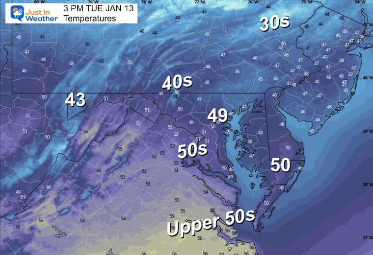
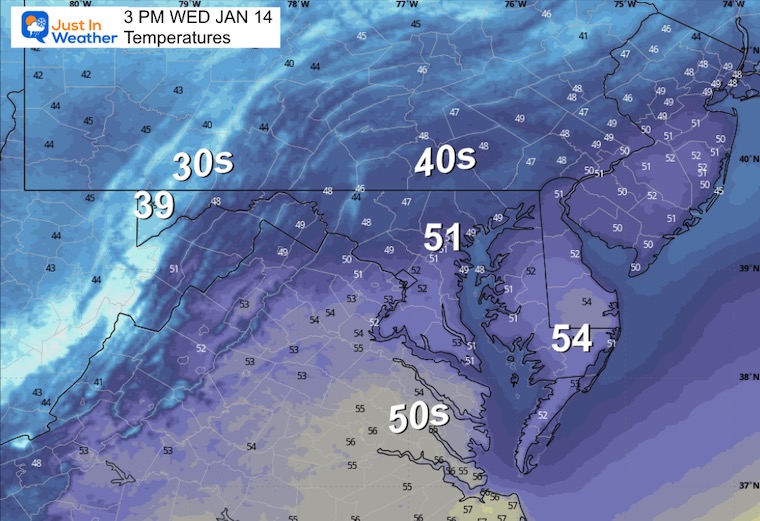
Afternoon Temperatures
MOUNTAIN CAM:
WESTERN MARYLAND
This webcam is positioned at The Greene Turtle Deep Creek Lake and shows Wisp Resort, including a zoomed-in view of Squirrel Cage, The Face, the terrain park, Boulder, the mountain coaster, the tubing park, and a shot of McHenry Cove at Deep Creek Lake!
CLIMATE DATA: Baltimore
Yesterday: Low 27°F; High 47°F
Precipitation: 0.00″
Season Snow Total: 2.0″
Snow Depth: 0″
Top Wind Gust: 25 mph
TODAY January 13
Sunrise at 7:25 AM
Sunset at 5:06 PM
Normal Low in Baltimore: 25ºF
Record Low: 0ºF in 1912 & 1981
Normal High in Baltimore: 43ºF
Record High: 76ºF in 1932
Rainfall Deficit at BWI
- Prior 2 Years (2024 + 2025) = -16.91″
- Since Jan 1, 2026 = -0.27″
WEDNESDAY
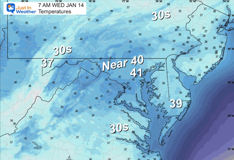
Morning Temperatures
Afternoon Temperatures
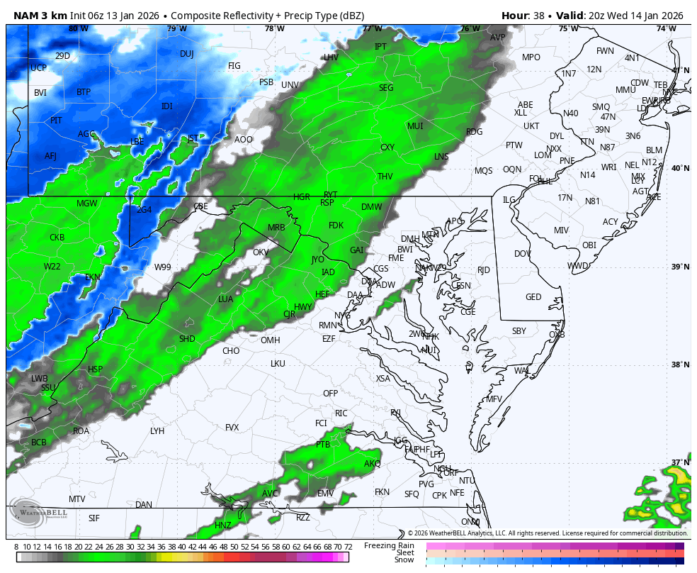
Afternoon Radar Forecast
A cold front will arrive with rain developing (at first).
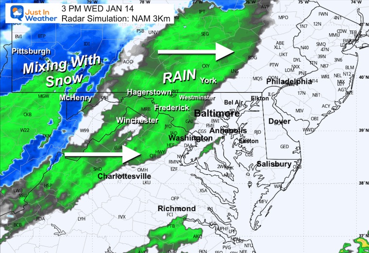
Radar Simulation 3 PM Wednesday to 7 PM
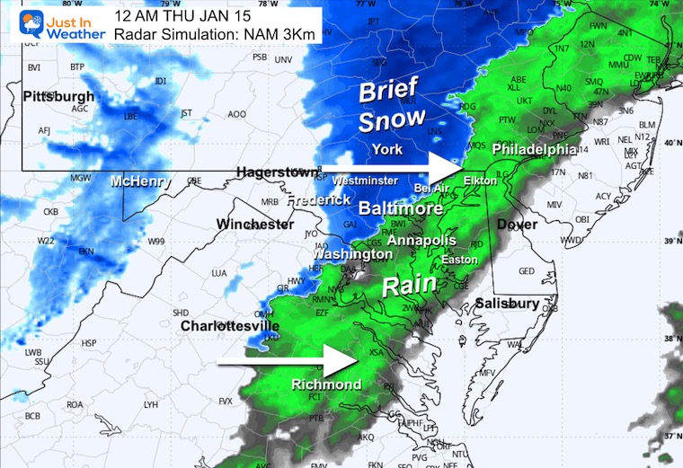
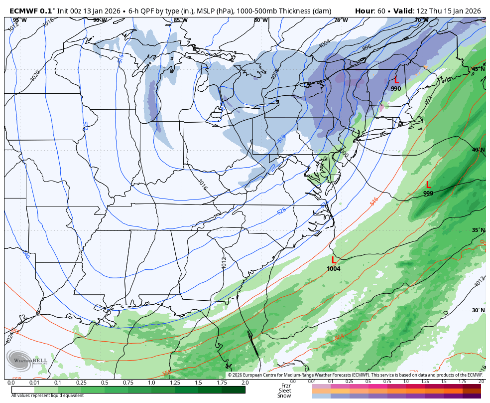
The cold front will include a transition from rain to snow overnight.
This brief period is all we will get from this system, and it will be done by morning.
Snapshots
Midnight Thursday
Rain to snow for an hour or two. This may drop a coating of snow with closer to 1 inch near and north of the PA line.
3 AM Thursday
A brief period of snow on Delmarva may also drop a coating of snow.
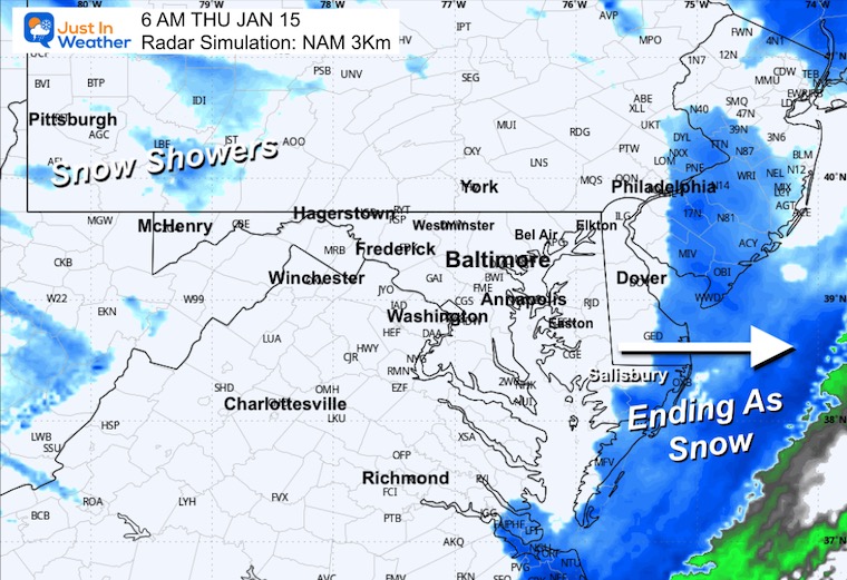
6 AM Thursday
Snow exiting the coast.
Snow Total POTENTIAL
This is the most I see possible and will be ending before sunrise on Thursday.
Storm Forecast Thursday to Saturday
As the cold air crosses the Eastern US, the snow will be prevalent across the Great Lakes. After the Wednesday night front, all I see are snow showers or flurries at times, but no major events on the horizon.
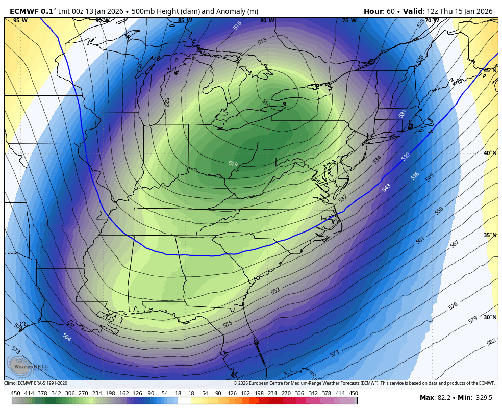
Jet Stream: Thursday Snapshot
This new push of arctic air will work all the way into the Deep South and Gulf Coast. We all transition to the colder air on Thursday.
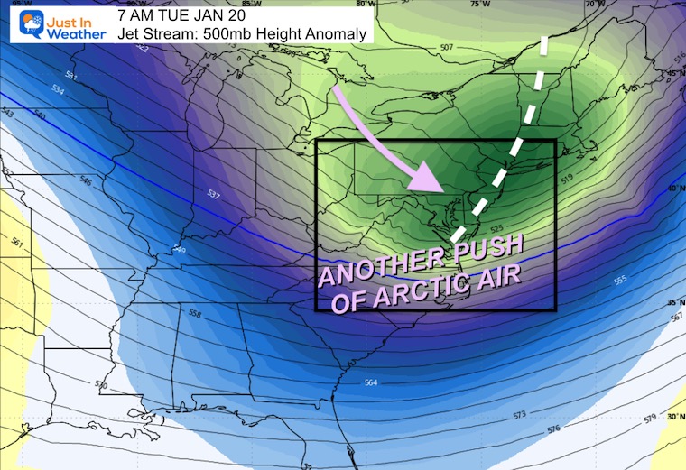
Jet Stream Forecast Jan 15 to Next Tue Jan 20
Reinforcing cold air over the next week, and it is likely more will follow.
While we may see some snow showers or flurries, I do not see any storms at this time.
Jet Stream: Next Tuesday Snapshot
The second push of arctic air may be colder for our region.
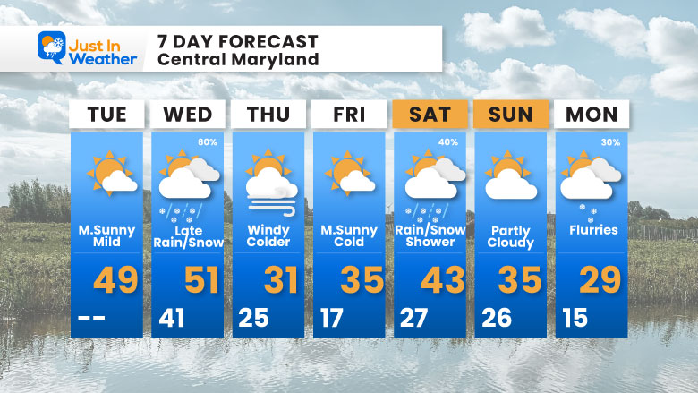
7-Day Forecast
Big temperature swing coming! From the low 50s on Wednesday down to the low 30s on Thursday — and look at that Monday low of 15°F! Winter is settling in for a while.
- Tuesday: Mostly sunny and mild. High 49°F.
- Wednesday: Late rain/snow (60%). High 51°F, Low 41°F.
- Thursday: Windy and colder. High 31°F, Low 25°F.
- Friday: Mostly sunny and cold. High 35°F, Low 17°F.
- Saturday: Rain/snow shower (40%). High 43°F, Low 27°F.
- Sunday: Partly cloudy. High 35°F, Low 26°F.
- Monday: Flurries (30%). High 29°F, Low 15°F.
Subscribe for email Alerts
FAITH IN THE FLAKES STORE
NOW OPEN FOR THE SEASON
click here

Snow Report December 14 and Grade My Forecast
In case you missed it, click this image for brief summary of the final snow totals from the last event.

Snow Report December 5 to 6 and Grade My Forecast
In case you missed it, click this image for brief summary of the final snow totals from the last event.

My Winter Outlook For Above-Average Snow
Click here for the full report

La Niña Advisory
This was issued October 9, as expected: A weak and short-lived event to start winter may play a different role this winter.

In Case You Missed It
Woolly Bear Caterpillar Winter Folklore
These are NOT all the same caterpillar!

Winter Outlook From 2 Farmers’ Almanacs

STEM Assemblies/In School Fields Trips Are Back
Click to see more and ‘Book’ a visit to your school

THANK YOU:
Baltimore Sun Magazine Readers’ Choice Best Of Baltimore

Maryland Trek 12 Day 7 Completed Sat August 9
UPDATED: We raised OVER $170,000 for Just In Power Kids – AND Still Collecting More
The annual event: Hiking and biking 329 miles in 7 days between The Summit of Wisp to Ocean City.
Each day, we honor a kid and their family’s cancer journey.
Fundraising is for Just In Power Kids: Funding Free Holistic Programs. I never have and never will take a penny. It is all for our nonprofit to operate.
Click here or the image to donate:

RESTATING MY MESSAGE ABOUT DYSLEXIA
I am aware there are some spelling and grammar typos and occasional other glitches. I take responsibility for my mistakes and even the computer glitches I may miss. I have made a few public statements over the years, but if you are new here, you may have missed it: I have dyslexia and found out during my second year at Cornell University. It didn’t stop me from getting my meteorology degree and being the first to get the AMS CBM in the Baltimore/Washington region. One of my professors told me that I had made it that far without knowing and to not let it be a crutch going forward. That was Mark Wysocki, and he was absolutely correct! I do miss my mistakes in my own proofreading. The autocorrect spell check on my computer sometimes does an injustice to make it worse. I can also make mistakes in forecasting. No one is perfect at predicting the future. All of the maps and information are accurate. The ‘wordy’ stuff can get sticky. There has been no editor who can check my work while writing and to have it ready to send out in a newsworthy timeline. Barbara Werner is a member of the web team that helps me maintain this site. She has taken it upon herself to edit typos when she is available. That could be AFTER you read this. I accept this and perhaps proves what you read is really from me… It’s part of my charm. #FITF
Please share your thoughts and best weather pics/videos, or just keep in touch via social media.


