Friday January 9
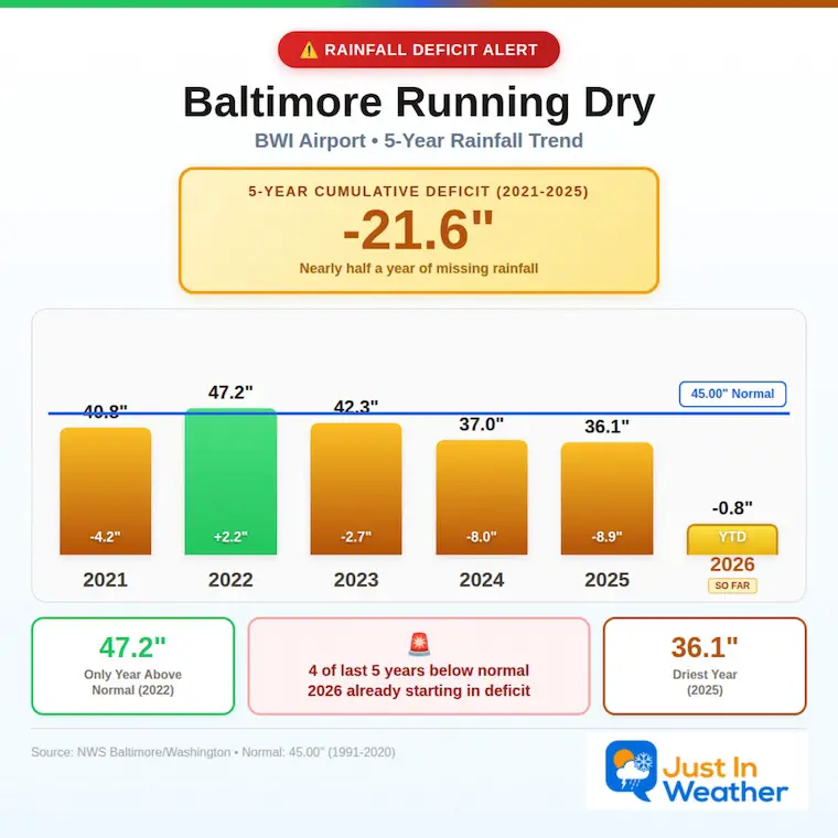
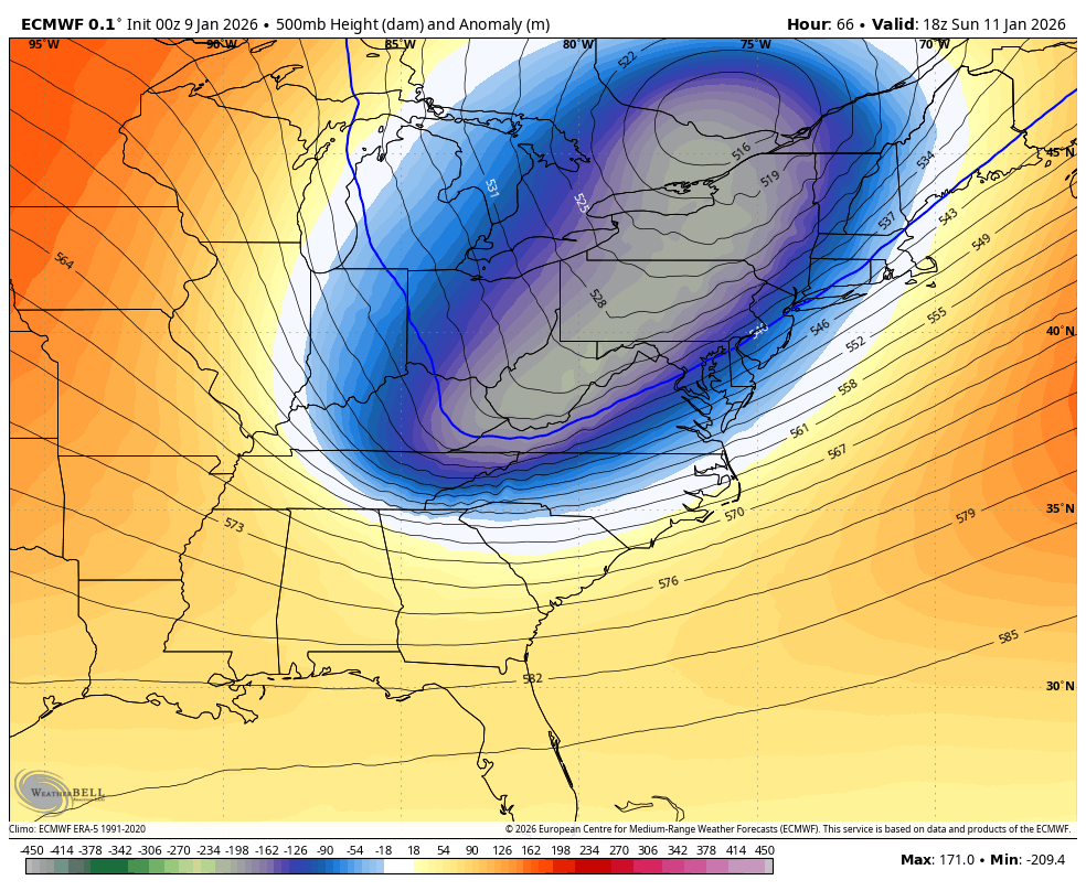
A large and complex storm map this morning demonstrates the rain on the way, and we need it. There has been a dominant deficit of precipitation in the Eastern US over the past decade. The most recent 5 years have us running a deficit equal to about 1/2 year of expected rainfall. This has also been reflected in below average winter snow.
Our expectation of close to 1 inch of rain is welcome, but still not nearly enough for groundwater systems.
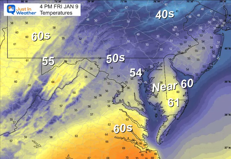
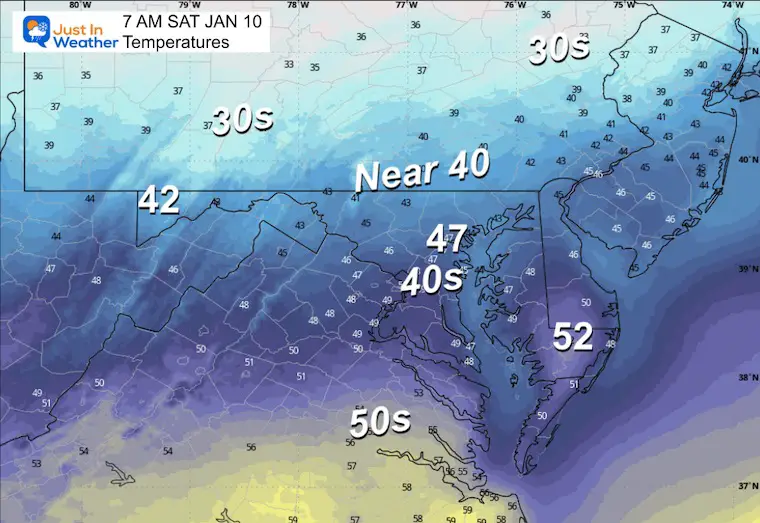
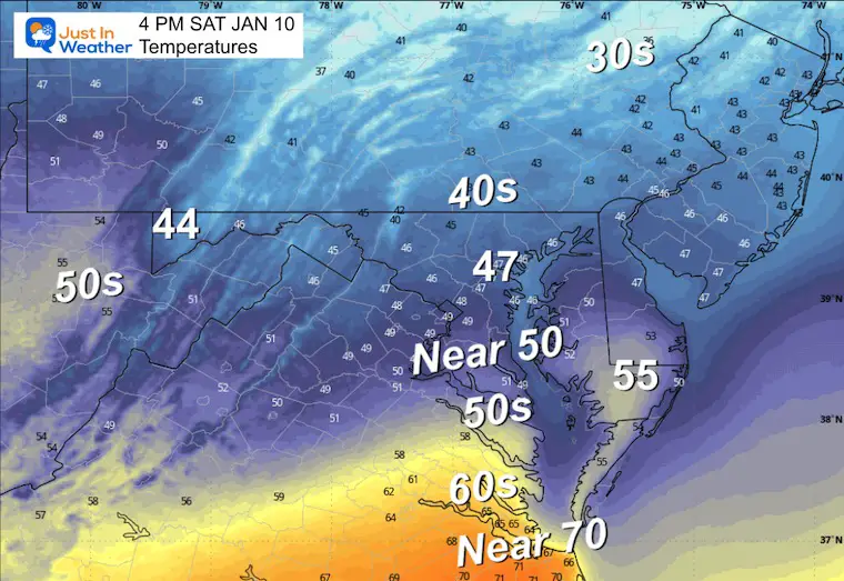
One other point with this weather system that is important: The warm air expectation has shifted south and NOT fully into our region. Instead of the 60s, many may struggle to get to 50F tomorrow. That demonstrates the difficulty computer guidance has in showing imperfection.
Most of this winter, I have seen the colder air be more prevalent, which may be a valuable feature to keep in mind as the winter weather pattern returns.
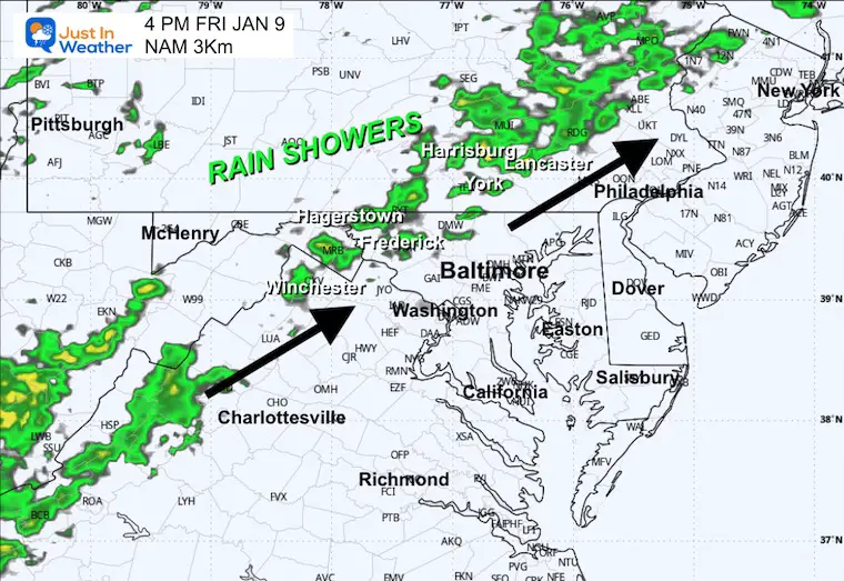
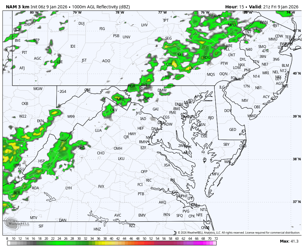
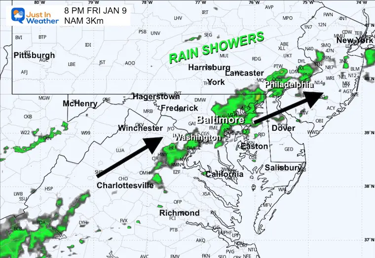
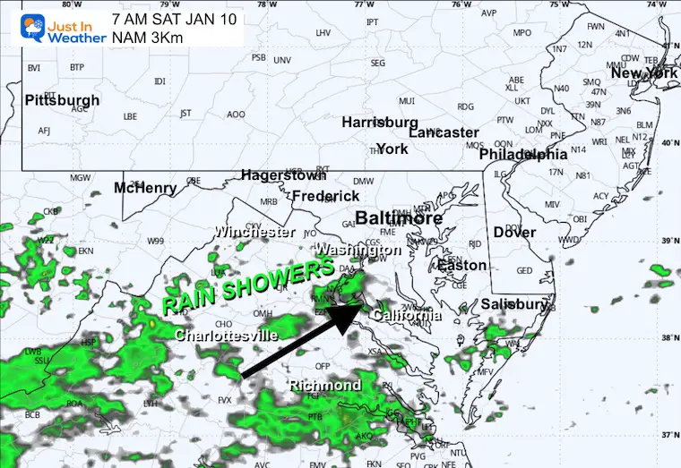
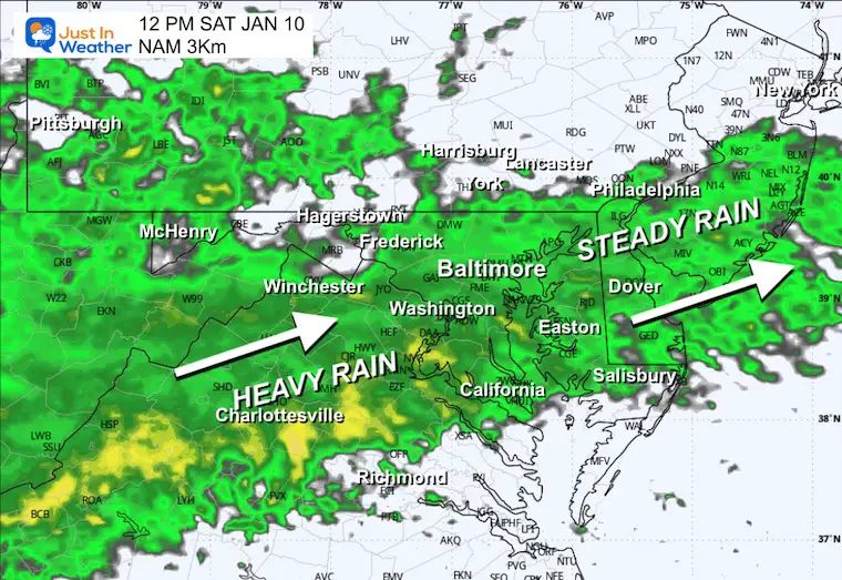
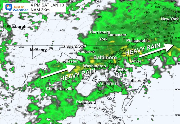
This rain will come in two parts. 1) Rain showers develop this afternoon to evening. 2) Steadier rain develops Saturday morning and will be both steady and heavy at times during the afternoon. This will be followed by colder winds and then a shift to a more winter-like pattern next week.
Rainfall Deficit
Morning Surface Weather
For Baltimore and the Mid-Atlantic: Dry this morning, but rain is on the way! A two-part storm system will bring rain to the region today and tomorrow.
- Part 1: Rain is moving through the Great Lakes and Ohio Valley, heading toward the Mid-Atlantic. This will bring showers to our region later today.
- Part 2: A second wave along the Gulf Coast with severe thunderstorms and flooding from Texas to Alabama. This energy will merge and bring heavier rain to our area on Saturday.
- Snow Out West: Colorado and the Rockies are seeing snow — a reminder that winter is still active elsewhere.
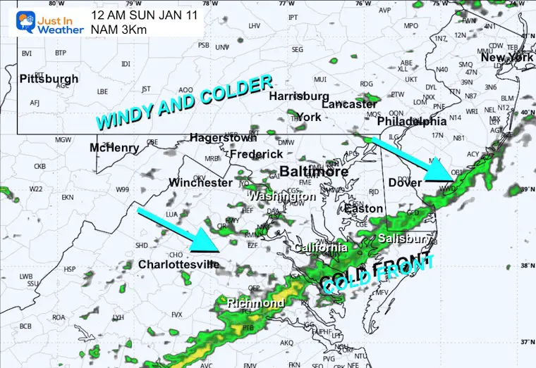
- Colder Air Coming: A cold front trailing behind this system will usher in colder air from Canada. Expect a return to seasonal temperatures by Sunday.
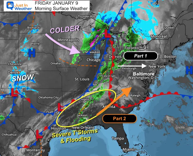
Quick Storm View: Friday to Sunday Morning
The two-part storm system will bring us the first wave of rain showers today, followed by heavier rain on Saturday. This will be the result of the severe storms and flooding in the Deep South.
Most important: The orientation shifts the warm air farther south. So we will NOT get into the 60s again this time.
Live Radar Widget
AFTERNOON Temperatures
Radar Snapshot at 4 PM
Radar Simulation 4 PM To Midnight
Radar Snapshot Friday Evening
MOUNTAIN CAM:
WESTERN MARYLAND
This webcam is positioned at The Greene Turtle Deep Creek Lake and shows Wisp Resort, including a zoomed-in view of Squirrel Cage, The Face, the terrain park, Boulder, the mountain coaster, the tubing park and a shot of McHenry Cove at Deep Creek Lake!
CLIMATE DATA: Baltimore
Yesterday: Low 29°F; High 56°F
Precipitation: 0.00″
Season Snow Total: 2.0″
Snow Depth: 0″
Top Wind Gust: 16 mph
TODAY January 9
Sunrise at 7:26 AM
Sunset at 5:02 PM
Normal Low in Baltimore: 26ºF
Record Low: 2ºF in 1970
Normal High in Baltimore: 43ºF
Record High: 75ºF in 1937
Rainfall Deficit at BWI
- Prior 2 Years (2024 + 2025) = -16.91″
- Since Jan 1, 2026 = -0.80″
SATURDAY
This will be our rainy day… developing in the morning, then steady and heavy at times in the afternoon.
Morning Temperature
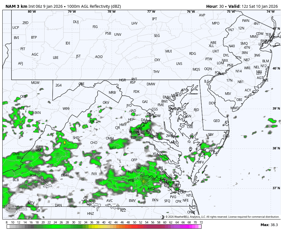
Morning Radar Snapshot
Radar Simulation 7 AM to Midnight
Noon Radar Snapshot
Afternoon Radar Snapshot
Afternoon Temperatures
Night View Cold Front
Colder winds will follow on Sunday.
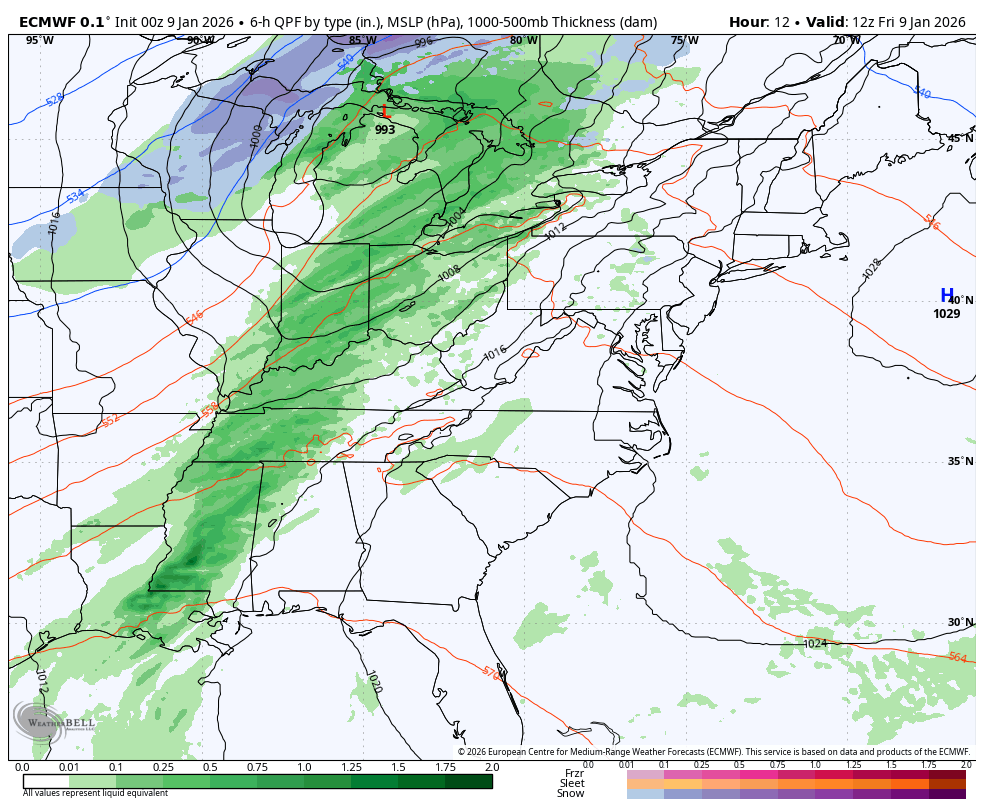
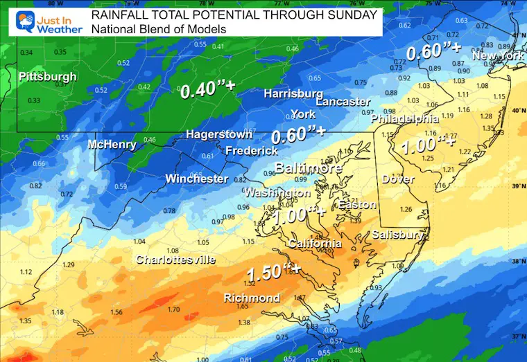
POTENTIAL TOTAL RAINFALL
This is from a blend of global models
A large swath of over 1 inch along the heavily populated I-95 corridor.
LOOKING AHEAD
Jet Stream Sunday
The first of several cold impulses of cold air will be pushing back into the Eastern US.
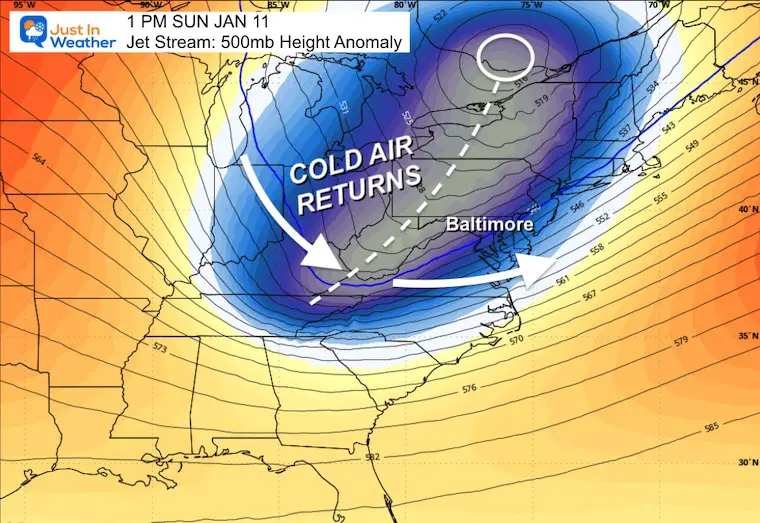
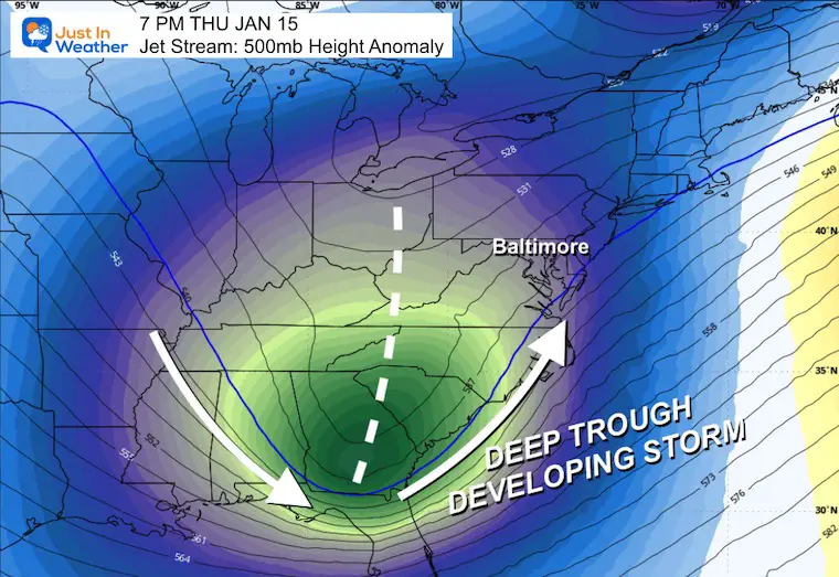
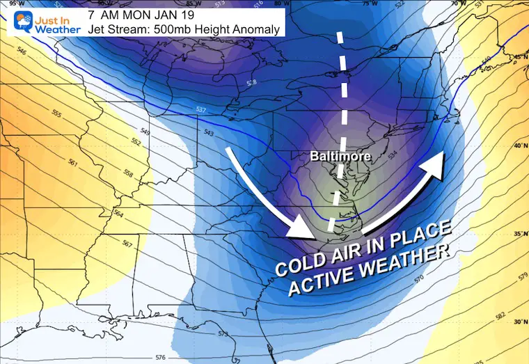
Jet Stream Forecast Sunday Jan 11 to Monday Jan 19
Here comes winter with a few impulses of colder and unsettled air. The deep trough in the jet stream is a signal of energy and POTENTIAL storm development. This pattern has high confidence. The specifics at the surface with a particular storm set up are less certain this far out.
Next Thursday Jan 15
This DEEP TROUGH is a strong signal of well below average temperatures into the Gulf Coast, and may help develop a new storm with winter weather.
Next Monday Jan 19
While in the midst of a colder pattern, we will watch for more energy to attempt snow production.
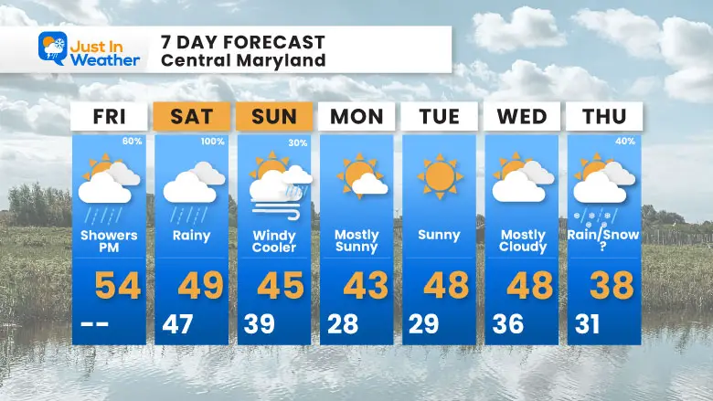
7-Day Forecast
Rain is guaranteed on Saturday, then it will cool down! And that Thursday system could be interesting with rain/snow potential — worth watching.
Friday: PM showers (80%). High 54°F.
Saturday: Rainy (100%). High 49°F, Low 47°F.
Sunday: Windy and cooler (30% showers). High 45°F, Low 39°F.
Monday: Mostly sunny. High 43°F, Low 28°F.
Tuesday: Sunny. High 48°F, Low 29°F.
Wednesday: Mostly cloudy. High 48°F, Low 36°F.
Thursday: Rain/Snow? (40%). High 38°F, Low 31°F.
Subscribe for email Alerts
FAITH IN THE FLAKES STORE
NOW OPEN FOR THE SEASON
click here

Snow Report December 14 and Grade My Forecast
In case you missed it, click this image for brief summary of the final snow totals from the last event.

Snow Report December 5 to 6 and Grade My Forecast
In case you missed it, click this image for brief summary of the final snow totals from the last event.

My Winter Outlook For Above-Average Snow
Click here for the full report

La Niña Advisory
This was issued October 9, as expected: A weak and short-lived event to start winter may play a different role this winter.

In Case You Missed It
Woolly Bear Caterpillar Winter Folklore
These are NOT all the same caterpillar!

Winter Outlook From 2 Farmers’ Almanacs

STEM Assemblies/In School Fields Trips Are Back
Click to see more and ‘Book’ a visit to your school

THANK YOU:
Baltimore Sun Magazine Readers’ Choice Best Of Baltimore

Maryland Trek 12 Day 7 Completed Sat August 9
UPDATED: We raised OVER $170,000 for Just In Power Kids – AND Still Collecting More
The annual event: Hiking and biking 329 miles in 7 days between The Summit of Wisp to Ocean City.
Each day, we honor a kid and their family’s cancer journey.
Fundraising is for Just In Power Kids: Funding Free Holistic Programs. I never have and never will take a penny. It is all for our nonprofit to operate.
Click here or the image to donate:

RESTATING MY MESSAGE ABOUT DYSLEXIA
I am aware there are some spelling and grammar typos and occasional other glitches. I take responsibility for my mistakes and even the computer glitches I may miss. I have made a few public statements over the years, but if you are new here, you may have missed it: I have dyslexia and found out during my second year at Cornell University. It didn’t stop me from getting my meteorology degree and being the first to get the AMS CBM in the Baltimore/Washington region. One of my professors told me that I had made it that far without knowing and to not let it be a crutch going forward. That was Mark Wysocki, and he was absolutely correct! I do miss my mistakes in my own proofreading. The autocorrect spell check on my computer sometimes does an injustice to make it worse. I can also make mistakes in forecasting. No one is perfect at predicting the future. All of the maps and information are accurate. The ‘wordy’ stuff can get sticky. There has been no editor who can check my work while writing and to have it ready to send out in a newsworthy timeline. Barbara Werner is a member of the web team that helps me maintain this site. She has taken it upon herself to edit typos when she is available. That could be AFTER you read this. I accept this and perhaps proves what you read is really from me… It’s part of my charm. #FITF
Please share your thoughts and best weather pics/videos, or just keep in touch via social media.


