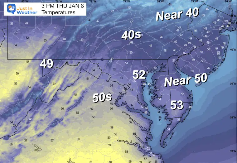
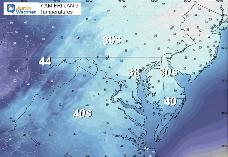
Thursday January 8
Yesterday, we saw a display of what has been quite common in winter. When we get a warm-up, it tends to be warmer than expected. Baltimore jumped to 62°F at BWI in the afternoon. Today, a wind shift will keep us mild, but almost 10 degrees cooler.
We start again with some areas of fog, then mostly sunny with a new round of clouds ahead of a two-part storm system.
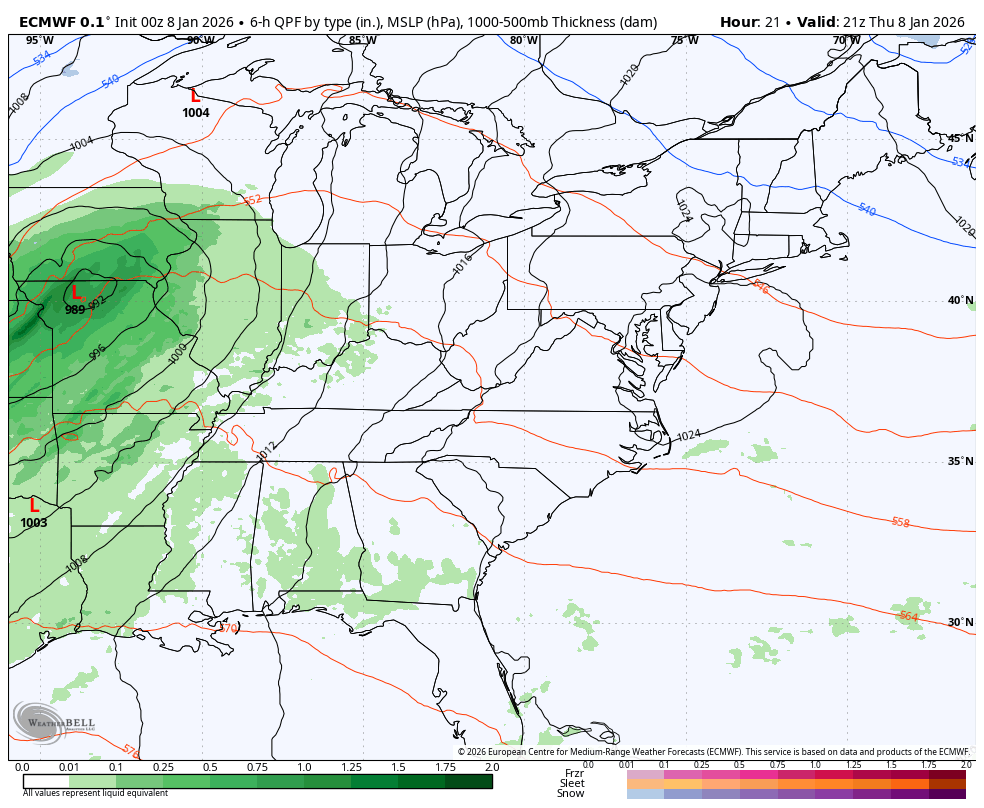
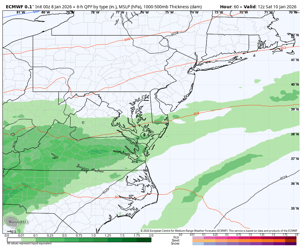
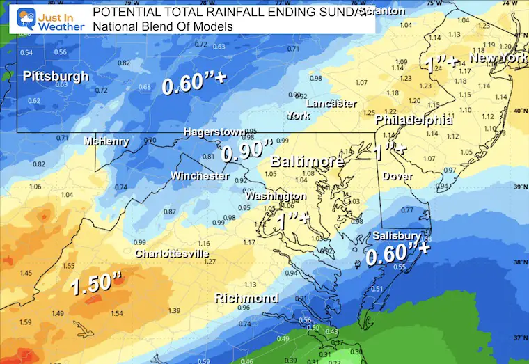
Our rainfall deficit is still a dominant long-term trend. Rain developing Friday will be steadier later in the day, followed by heavier rain on Saturday. Totals may reach 1 inch in many areas.
After that passes, a return to seasonal temperatures will follow to start next week.
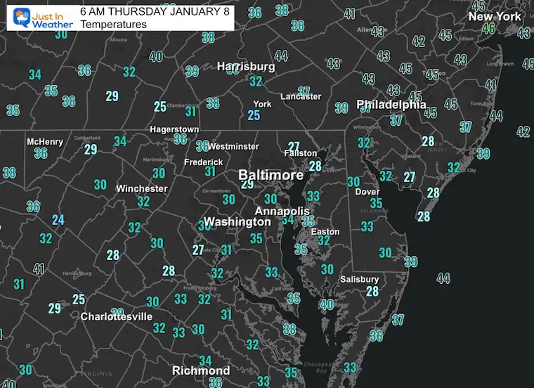
Morning Temperatures
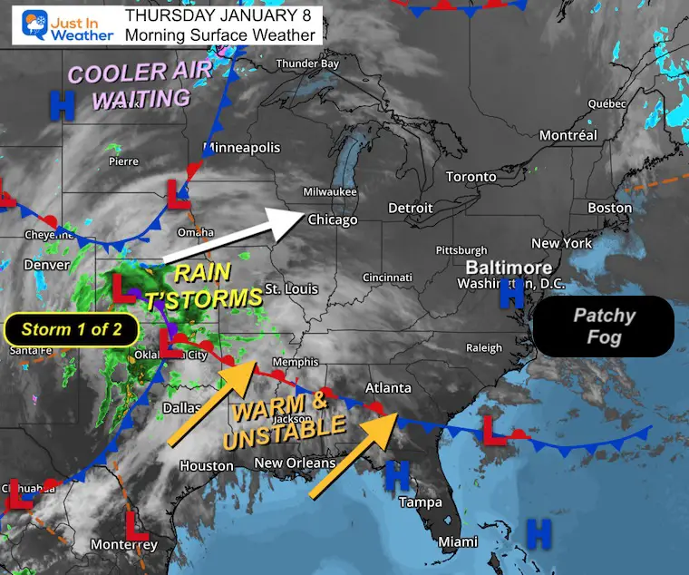
Morning Surface Weather
For Baltimore and the Mid-Atlantic: Patchy fog again this morning, but we remain in the warm and mild air. The January Thaw continues, but change is on the way.
- Storm 1 of 2: Rain and thunderstorms are firing up across Texas, Oklahoma, and the southern Plains. This is the first of two systems that will bring rain to our region — arriving Friday into Saturday.
- Warm and Unstable: A surge of warm, unstable air is pushing northeast from the Gulf Coast through the Southeast. This will fuel the rain and keep temperatures mild through the weekend.
- Cooler Air Waiting: High pressure and cooler air are building across Canada and the northern Plains. This cold air will make its move after the weekend rain clears out.
Quick Storm View: Thursday Afternoon to Sunday Morning
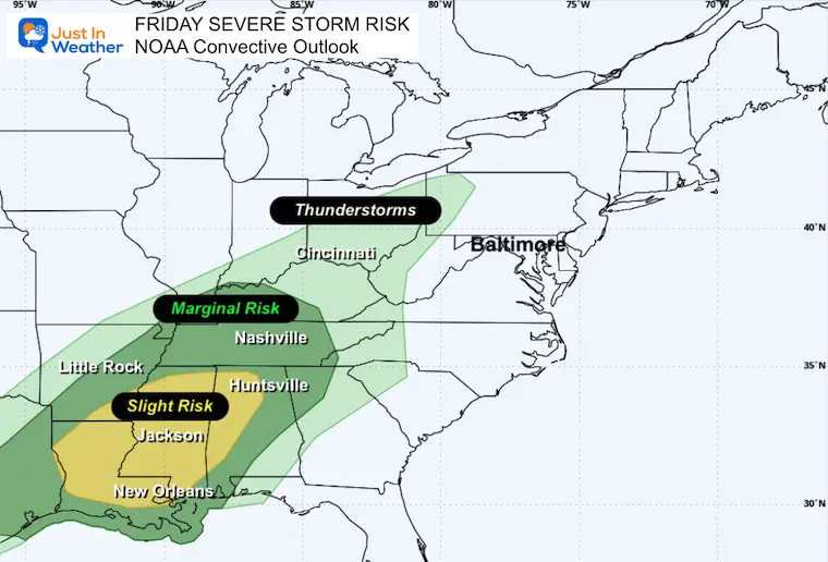
The two-part storm system will include the potential for severe weather in the Deep South. That is what will feed heavier rain into our region on Saturday, followed by the return to seasonal temperatures. Snow showers will fall in the mountains on Sunday.
NOAA Severe Storm Outlook TOMORROW
The risk of severe thunderstorms is a display of the energy of the storm, and why heavier rain will come our way on Saturday.
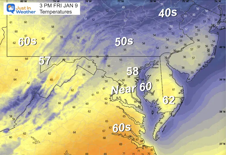
AFTERNOON Temperatures
MOUNTAIN CAM:
WESTERN MARYLAND
This webcam is positioned at The Greene Turtle Deep Creek Lake and shows Wisp Resort, including a zoomed-in view of Squirrel Cage, The Face, the terrain park, Boulder, the mountain coaster, the tubing park and a shot of McHenry Cove at Deep Creek Lake!
CLIMATE DATA: Baltimore
Yesterday: Low 30°F; High 62°F
Precipitation: 0.00″
Season Snow Total: 2.0″
Snow Depth: 0″
Top Wind Gust: 38 mph
TODAY January 8
Sunrise at 7:26 AM
Sunset at 5:01 PM
Normal Low in Baltimore: 26ºF
Record Low: 4ºF in 1970
Normal High in Baltimore: 43ºF
Record High: 70ºF in 2008
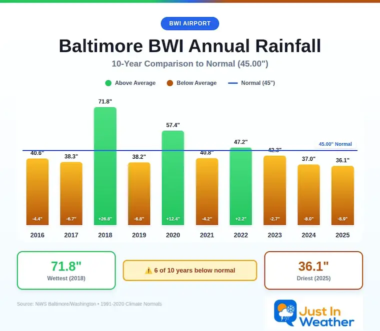
Rainfall Deficit at BWI
- Prior 2 Years (2024 + 2025) = -16.91″
- Since Jan 1, 2026 = -0.70″
Deeper Dive Into The Rain Deficit
When I say we need rain, this is why: Over just the last 4 years, we can see 2022 and 2023 balancing each other out. But the past two years have left the region with 16.91 inches BELOW AVERAGE rainfall. That cumulative effect is most noticeable in the deep ground/well water system.
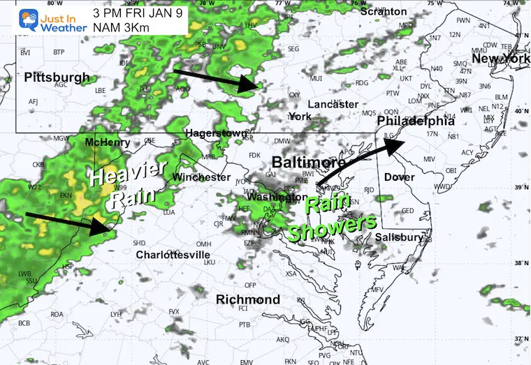
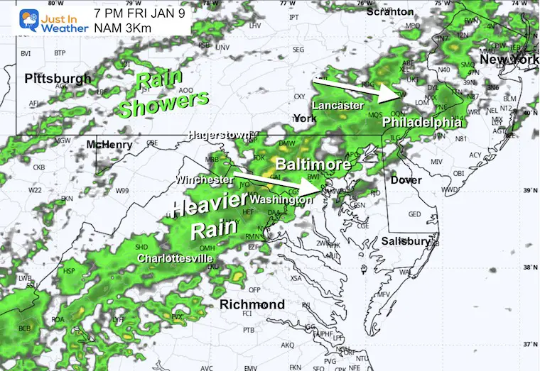
FRIDAY
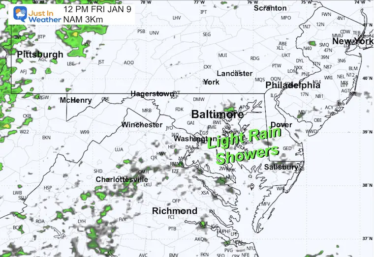
A cloudy day with light rain showers developing midday, then heavier rain later in the afternoon into the evening and overnight.
Morning Temperatures
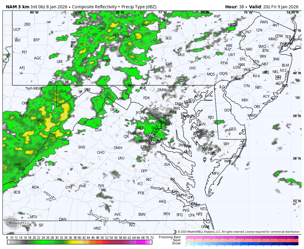
Noon Radar Snapshot
Afternoon Temperatures
Afternoon Radar Snapshot
Radar Simulation 3 PM to midnight
Evening Snapshot
The heaviest rain may fall around dinner time or when heading out for evening plans.
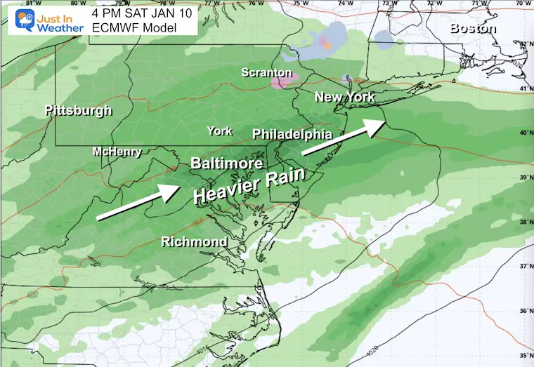
Storm Forecast Saturday to Sunday
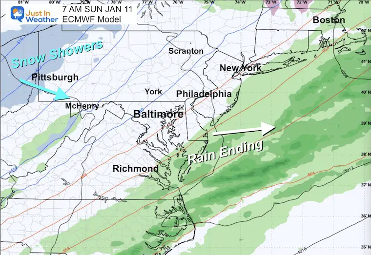
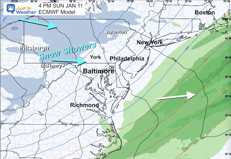
The second storm will bring in more rain reaching our region Saturday, followed by the return of colder air on Sunday with snow showers in the high mountains. Some flurries may reach the inland suburban hills later Sunday afternoon.
Saturday Afternoon
The heaviest rain in this two-part system is expected at this time.
Sunday Morning
Rain will be exiting the coast.
Sunday Afternoon
Colder air and snow showers will return to the mountains.
Gusty winds bring in cooler air to metro areas. Some flurries are possible in the inland hills.
POTENTIAL TOTAL RAINFALL
This is from a blend of global models.
A large swath of over 1 inch along the heavily populated I-95 corridor.
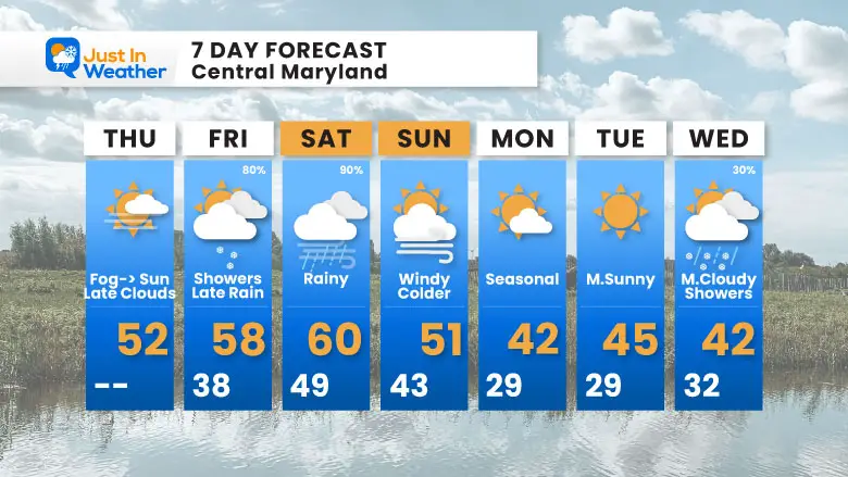
7-Day Forecast
January Thaw peaks again Friday and Saturday with highs near 60°F and needed rain — then winter returns Sunday with wind and colder temps!
Thursday: Fog to sun, then late clouds. High 52°F.
Friday: Showers, late rain (80%). High 58°F, Low 38°F.
Saturday: Rainy (90%). High 60°F, Low 49°F.
Sunday: Windy and colder. High 51°F, Low 43°F.
Monday: Seasonal. High 42°F, Low 29°F.
Tuesday: Mostly sunny. High 45°F, Low 29°F.
Wednesday: Mostly cloudy with showers (30%). High 42°F, Low 32°F.
Subscribe for email Alerts
FAITH IN THE FLAKES STORE
NOW OPEN FOR THE SEASON
click here

Snow Report December 14 and Grade My Forecast
In case you missed it, click this image for brief summary of the final snow totals from the last event.

Snow Report December 5 to 6 and Grade My Forecast
In case you missed it, click this image for brief summary of the final snow totals from the last event.

My Winter Outlook For Above-Average Snow
Click here for the full report

La Niña Advisory
This was issued October 9, as expected: A weak and short-lived event to start winter may play a different role this winter.

In Case You Missed It
Woolly Bear Caterpillar Winter Folklore
These are NOT all the same caterpillar!

Winter Outlook From 2 Farmers’ Almanacs

STEM Assemblies/In School Fields Trips Are Back
Click to see more and ‘Book’ a visit to your school

THANK YOU:
Baltimore Sun Magazine Readers’ Choice Best Of Baltimore

Maryland Trek 12 Day 7 Completed Sat August 9
UPDATED: We raised OVER $170,000 for Just In Power Kids – AND Still Collecting More
The annual event: Hiking and biking 329 miles in 7 days between The Summit of Wisp to Ocean City.
Each day, we honor a kid and their family’s cancer journey.
Fundraising is for Just In Power Kids: Funding Free Holistic Programs. I never have and never will take a penny. It is all for our nonprofit to operate.
Click here or the image to donate:

RESTATING MY MESSAGE ABOUT DYSLEXIA
I am aware there are some spelling and grammar typos and occasional other glitches. I take responsibility for my mistakes and even the computer glitches I may miss. I have made a few public statements over the years, but if you are new here, you may have missed it: I have dyslexia and found out during my second year at Cornell University. It didn’t stop me from getting my meteorology degree and being the first to get the AMS CBM in the Baltimore/Washington region. One of my professors told me that I had made it that far without knowing and to not let it be a crutch going forward. That was Mark Wysocki, and he was absolutely correct! I do miss my mistakes in my own proofreading. The autocorrect spell check on my computer sometimes does an injustice to make it worse. I can also make mistakes in forecasting. No one is perfect at predicting the future. All of the maps and information are accurate. The ‘wordy’ stuff can get sticky. There has been no editor who can check my work while writing and to have it ready to send out in a newsworthy timeline. Barbara Werner is a member of the web team that helps me maintain this site. She has taken it upon herself to edit typos when she is available. That could be AFTER you read this. I accept this and perhaps proves what you read is really from me… It’s part of my charm. #FITF
Please share your thoughts and best weather pics/videos, or just keep in touch via social media.


