Wednesday, January 7, 2025
Today will be a special day of sorts in the Baltimore area. In addition to finally getting the sunshine to return, we will see that first sunset back at 5 PM later today. Also, timing out with this benchmark will be a warm-up back to the 50s. The next five days will remain warm, with even a day in the 60s, which will come with rain.
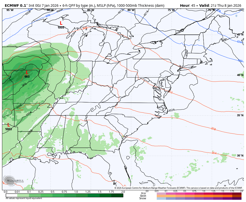
The storm arriving at the end of the week may bring one inch of needed rain, followed by a return to near normal temperatures.
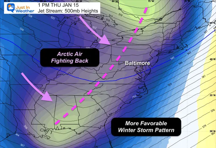
The return of an arctic air-dominated pattern and a more favorable winter storm track looks more probable next week
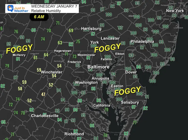
Morning Fog
Where the Relative Humidity is approaching or at 100%, the air is saturated, and fog is developing or getting thicker.
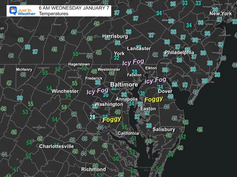
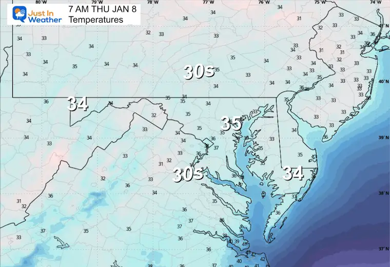
Morning Temperatures
Some places where fog has developed are near or below freezing. Note that your car can be colder than the air, and ice may need to be scraped off the windows even with temps in the mid 30s.
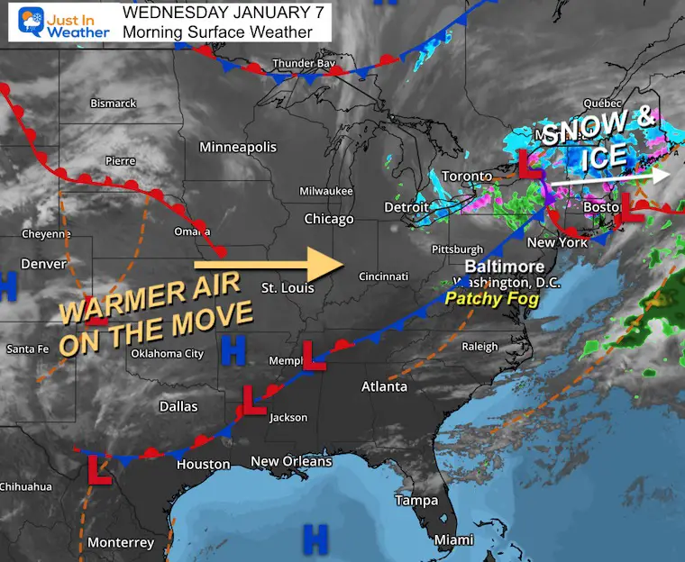
Morning Surface Weather
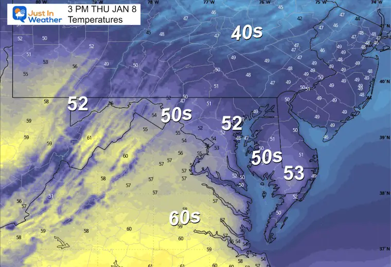
For Baltimore and the Mid-Atlantic: Patchy fog this morning, but clearing skies are on the way. The January Thaw continues as warmer air pushes into the region today — expect sunshine and highs in the mid-50s!
- Snow and Ice to Our North: A system is producing snow and ice across eastern Canada and northern New England — well north of us and moving away.
- Warmer Air on the Move: A surge of mild air is flowing northeast from Texas through the Ohio Valley and heading our way. This is the engine behind our warm-up through the weekend.
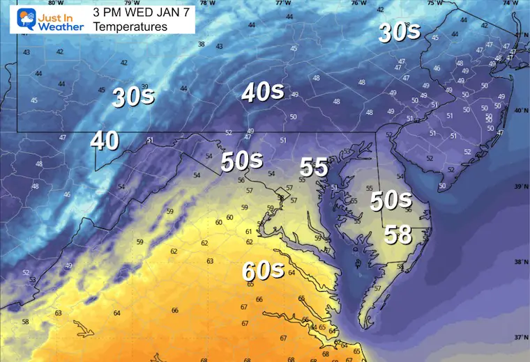
AFTERNOON Temperatures
MOUNTAIN CAM:
WESTERN MARYLAND
This webcam is positioned at The Greene Turtle Deep Creek Lake and shows Wisp Resort, including a zoomed-in view of Squirrel Cage, The Face, the terrain park, Boulder, the mountain coaster, the tubing park and a shot of McHenry Cove at Deep Creek Lake!
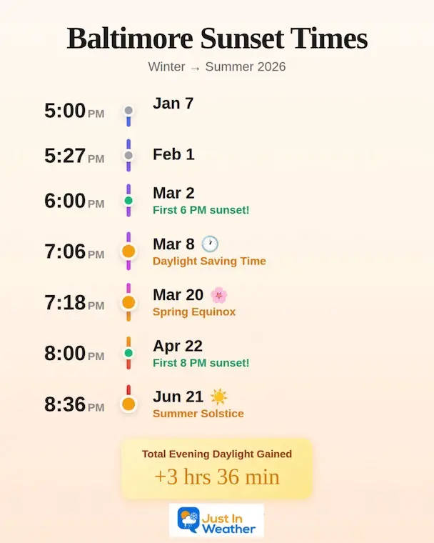
Sunset Times In Baltimore
Today, we return to 5 PM Sunset. This is what lies ahead:
CLIMATE DATA: Baltimore
Yesterday: Low 29°F; High 44°F
Precipitation: 0.00″
Season Snow Total: 2.0″
Snow Depth: 0″
Top Wind Gust: 14 mph
TODAY January 7
Sunrise at 7:26 AM
Sunset at 5:00 PM
Normal Low in Baltimore: 26ºF
Record Low: 1ºF in 2018
Normal High in Baltimore: 43ºF
Record High: 74ºF in 1907
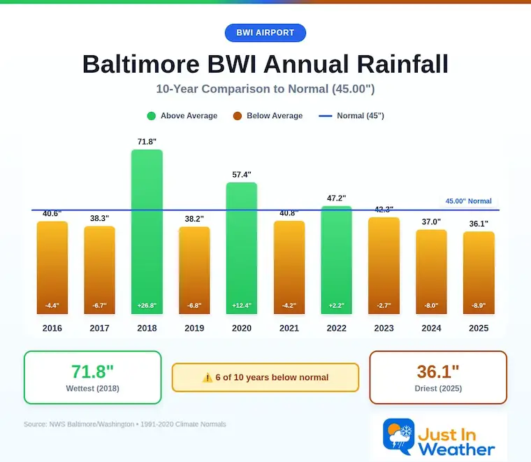
Rainfall Deficit at BWI
- Prior 2 Years (2024 + 2025) = -16.91″
- Since Jan 1, 2026 = -0.61″
Deeper Dive Into The Rain Deficit
When I say we need rain, this is why: Over just the last 4 years, we can see 2022 and 2023 balancing each other out. But the past two years have left the region with 16.91 inches BELOW AVERAGE rainfall. That cumulative effect is most noticeable in the deep ground/well water system.
THURSDAY
Morning Temperatures
Afternoon Temperatures
Storm Map
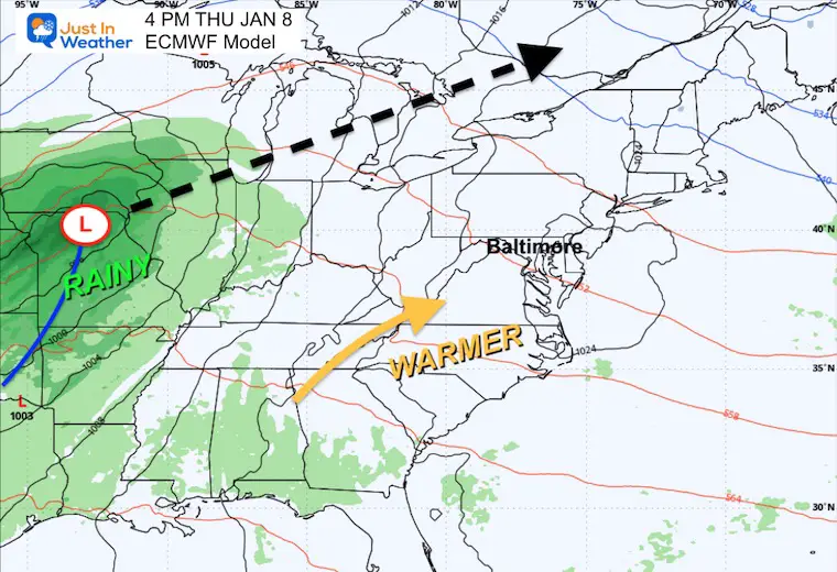
Low Pressure developing in the Central US will be tracking to our North into the Great Lakes, allowing warmer air to push up into our region. This sets up the stage for the next storm with more rain to arrive later in the week.
LOOKING AHEAD
Storm Forecast Thursday to Sunday
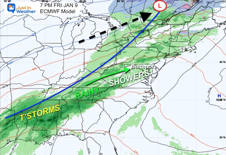
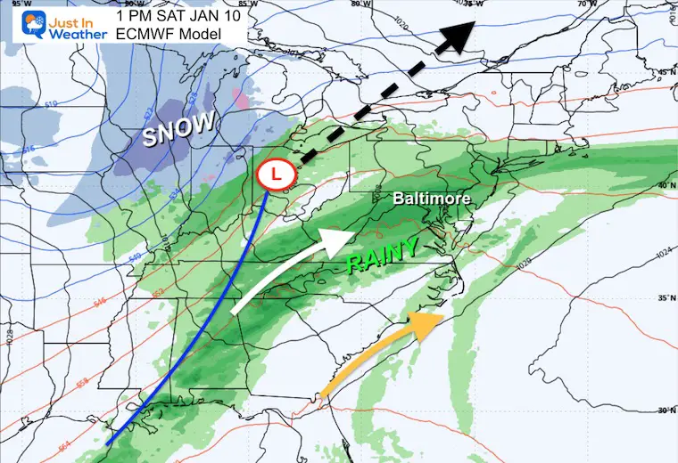
The second storm will bring in more rain, reaching our region later Friday and Saturday, followed by the return of colder air.
Friday Night
Rain showers with warm air holding overnight.
Saturday
Steady rain is likely throughout the day.
Sunday
Colder air spills in with temps sliding back closer to average. Lake Effect snow will return, and we can’t rule out flurries across our northern zones or the mountains.
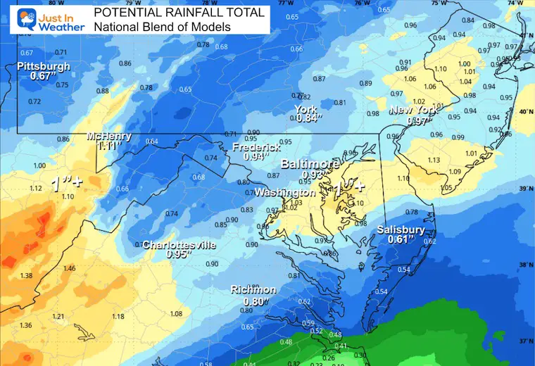
Rain Total Potential
Not all areas will reach 1 inch, but we should get close with well over 1/2 inch of rain.
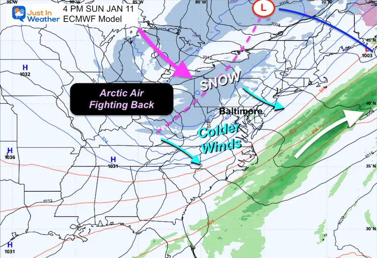
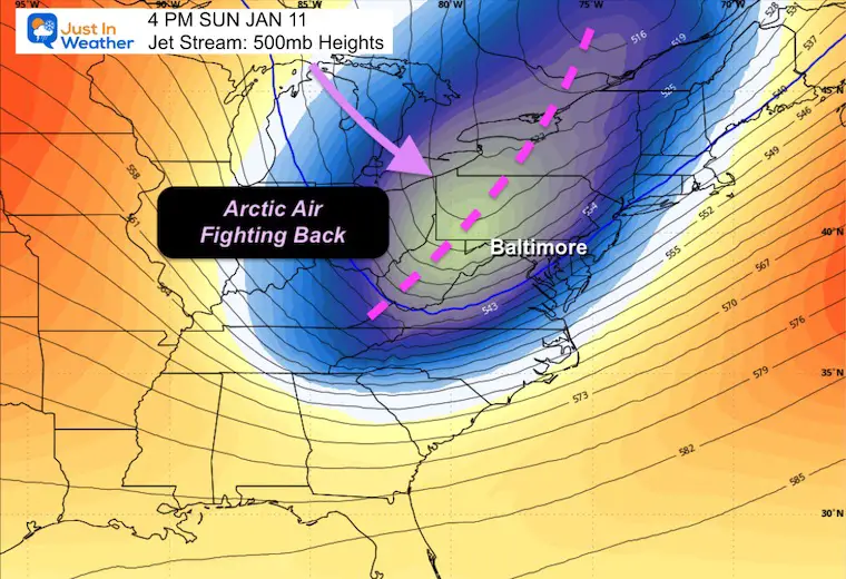
Sunday Jet Stream
A return of colder air will bring near-normal temperatures.
Jet Stream: Jan 11 to Jan 15
The global weather pattern brings the return of an arctic-dominated pattern to focus the cold air back into the Eastern US next week.
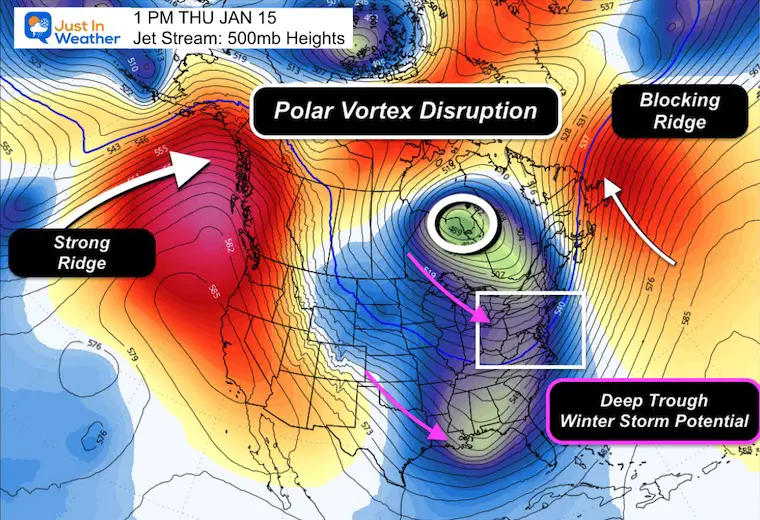
Next Thursday Jet Stream
A much deeper trough will set up in the Eastern US. This is a more favorable pattern for winter storms to develop between the Gulf and East Coast.
North American View
The breakdown and disruption of the Polar Vortex next week will include a large ridge in the Eastern Pacific/Western US and a Blocking Ridge in the North Atlantic/Greenland.
This favors the cold and stormy winter pattern for the Eastern US. Winter will be reloaded.
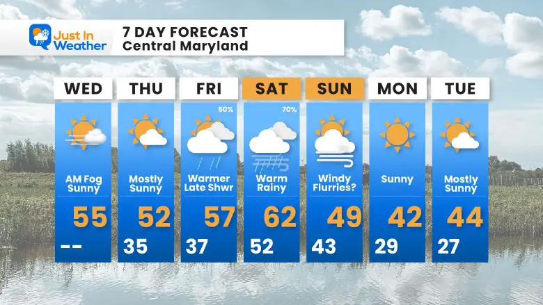
7-Day Forecast
January Thaw starts today and peaks Saturday with highs in the mid-50s to low 60s! Then the cold returns Sunday with wind and possible flurries.
Wednesday: AM fog, then sunny. High 55°F.
Thursday: Mostly sunny. High 52°F, Low 35°F.
Friday: Warmer with late showers (50%). High 57°F, Low 37°F.
Saturday: Warm and rainy (70%). High 62°F, Low 52°F.
Sunday: Windy with flurries possible. High 49°F, Low 43°F.
Monday: Sunny. High 42°F, Low 29°F.
Tuesday: Mostly sunny. High 44°F, Low 27°F.
Subscribe for email Alerts
FAITH IN THE FLAKES STORE
NOW OPEN FOR THE SEASON
click here

Snow Report December 14 and Grade My Forecast
In case you missed it, click this image for brief summary of the final snow totals from the last event.

Snow Report December 5 to 6 and Grade My Forecast
In case you missed it, click this image for brief summary of the final snow totals from the last event.

My Winter Outlook For Above-Average Snow
Click here for the full report

La Niña Advisory
This was issued October 9, as expected: A weak and short-lived event to start winter may play a different role this winter.

In Case You Missed It
Woolly Bear Caterpillar Winter Folklore
These are NOT all the same caterpillar!

Winter Outlook From 2 Farmers’ Almanacs

STEM Assemblies/In School Fields Trips Are Back
Click to see more and ‘Book’ a visit to your school

THANK YOU:
Baltimore Sun Magazine Readers’ Choice Best Of Baltimore

Maryland Trek 12 Day 7 Completed Sat August 9
UPDATED: We raised OVER $170,000 for Just In Power Kids – AND Still Collecting More
The annual event: Hiking and biking 329 miles in 7 days between The Summit of Wisp to Ocean City.
Each day, we honor a kid and their family’s cancer journey.
Fundraising is for Just In Power Kids: Funding Free Holistic Programs. I never have and never will take a penny. It is all for our nonprofit to operate.
Click here or the image to donate:

RESTATING MY MESSAGE ABOUT DYSLEXIA
I am aware there are some spelling and grammar typos and occasional other glitches. I take responsibility for my mistakes and even the computer glitches I may miss. I have made a few public statements over the years, but if you are new here, you may have missed it: I have dyslexia and found out during my second year at Cornell University. It didn’t stop me from getting my meteorology degree and being the first to get the AMS CBM in the Baltimore/Washington region. One of my professors told me that I had made it that far without knowing and to not let it be a crutch going forward. That was Mark Wysocki, and he was absolutely correct! I do miss my mistakes in my own proofreading. The autocorrect spell check on my computer sometimes does an injustice to make it worse. I can also make mistakes in forecasting. No one is perfect at predicting the future. All of the maps and information are accurate. The ‘wordy’ stuff can get sticky. There has been no editor who can check my work while writing and to have it ready to send out in a newsworthy timeline. Barbara Werner is a member of the web team that helps me maintain this site. She has taken it upon herself to edit typos when she is available. That could be AFTER you read this. I accept this and perhaps proves what you read is really from me… It’s part of my charm. #FITF
Please share your thoughts and best weather pics/videos, or just keep in touch via social media.


