


January 6 Weather Some Fog And Clouds Followed By The Warm Up With Rain By The Weekend
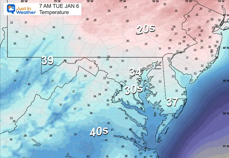
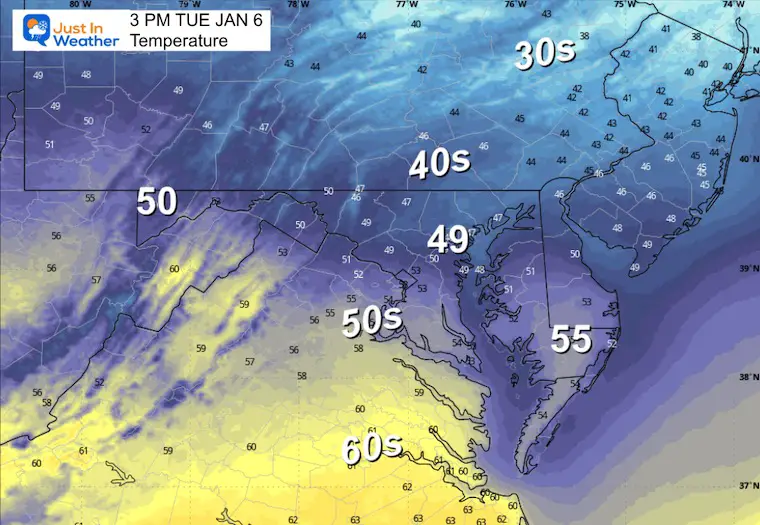
Tuesday, January 6, 2026 The storm track has shifted to the north. We are still on the edge, which is why we have areas of fog, and most of the…
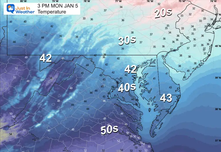
Monday, January 5, 2026
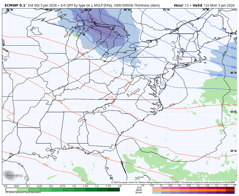
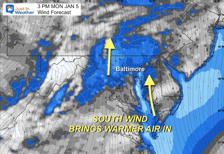
Clouds are returning, and one more disturbance could produce spotty flurries today as the leading edge of warmer air tries to move in. We will notice the temps with sunshine mid-week, then even warmer ahead of the next storm system that will bring rain on Friday and Saturday.
This is known as the January Thaw, and is pretty common within a cold pattern.
December ended 4.4°F below average, and so far this month, 4.5°F below average. This week will swing the balance the other way, but there is more cold air in sight. Winter will be reloading and making a return mid-month. This is a signal, not a promise, for winter weather to return.

A few flurries are possible today, but temperatures will begin climbing.
The warm-up kicks into gear mid-week with highs reaching the 50s and 60s.
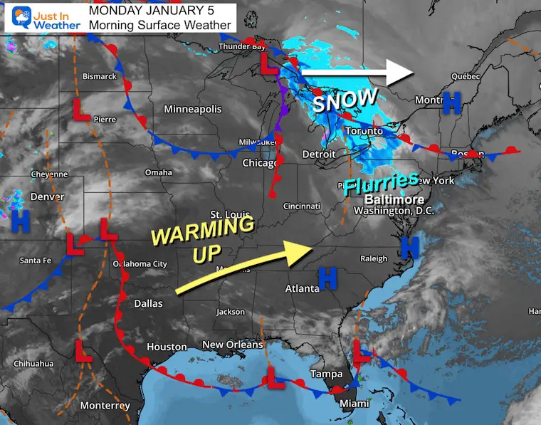
The next weather system will track to our north and signal the change of the weather pattern that will allow warmer air to flow our way.
This webcam is positioned at The Greene Turtle Deep Creek Lake and shows Wisp Resort, including a zoomed-in view of Squirrel Cage, The Face, the terrain park, Boulder, the mountain coaster, the tubing park and a shot of McHenry Cove at Deep Creek Lake!
Yesterday: Low 24°F; High 41°F
Precipitation: 0.00″
Season Snow Total: 2.0″
Snow Depth: 0″
Top Wind Gust: 25 mph
Sunrise at 7:26 AM
Sunset at 4:58 PM
Normal Low in Baltimore: 26ºF
Record Low: 1ºF in 1877
Normal High in Baltimore: 44ºF
Record High: 69ºF in 1997
Rainfall Deficit at BWI
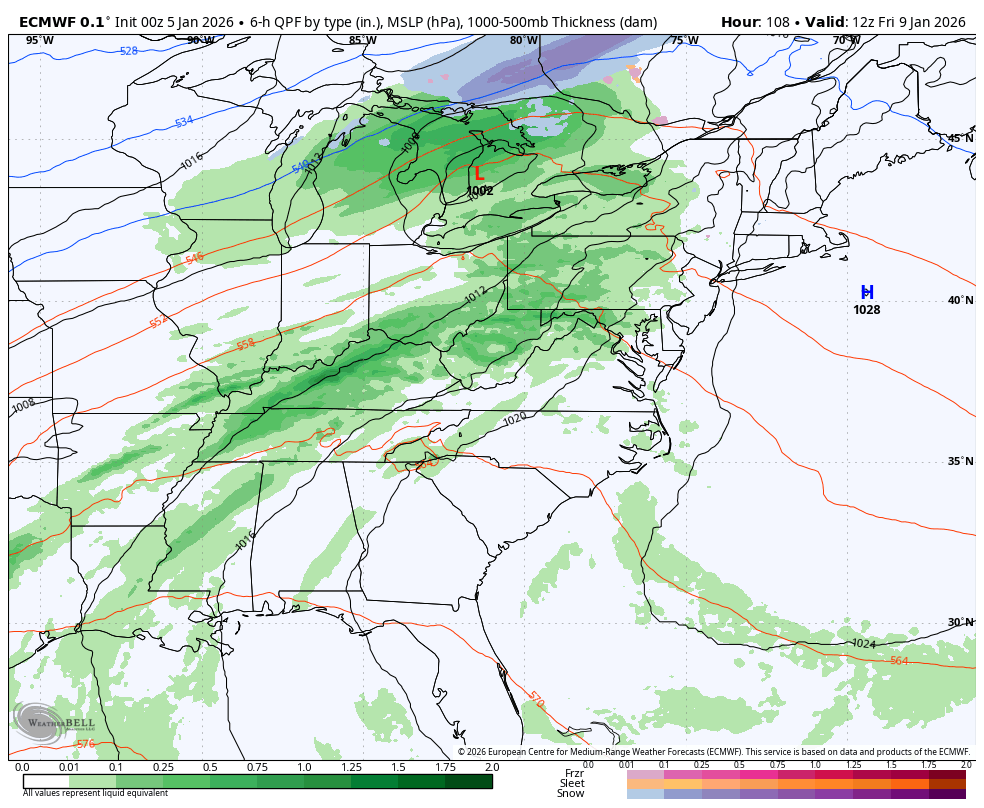
With High Pressure off the East Coast, warmer air will be flowing in. This will feed into the Cold Front to develop rain. How warm our temperatures may get could be mitigated by how much rain falls.

The storm track will be to our North and the trailing cold front will keep the risk of rain for two days.
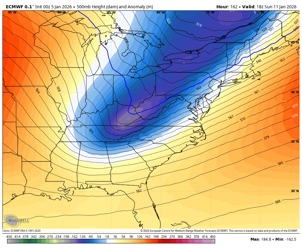
Then colder air will follow on Sunday… just transitioning us back to near normal temps. This is not an Arctic push.


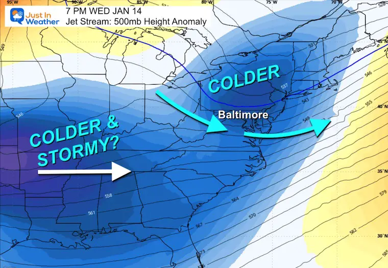
This first push of colder air will transition us back to near normal temps. Then another push of cold air may be working with a more active southern storm track.
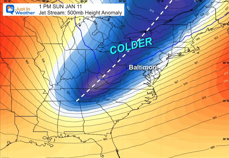
Since this is beyond one week away, it is subject to change with specifics. The overall pattern will be more active and colder NEXT WEEK.
January Thaw will be in full swing later this week and starting the weekend with highs in the 50s and 60s! Then the cold returns next Sunday.
Monday: Mostly cloudy with flurries. High 42°F.
Tuesday: Mostly cloudy. High 49°F, Low 34°F.
Wednesday: Sunny and mild. High 55°F, Low 41°F.
Thursday: Mostly sunny. High 53°F, Low 35°F.
Friday: Rain (50%). High 62°F, Low 42°F.
Saturday: Rain (60%). High 63°F, Low 54°F.
Sunday: Colder winds. High 48°F, Low 40°F.

Subscribe for email Alerts
Sign up and be the first to know!

In case you missed it, click this image for brief summary of the final snow totals from the last event.

In case you missed it, click this image for brief summary of the final snow totals from the last event.

Click here for the full report

This was issued October 9, as expected: A weak and short-lived event to start winter may play a different role this winter.

These are NOT all the same caterpillar!


Click to see more and ‘Book’ a visit to your school


The annual event: Hiking and biking 329 miles in 7 days between The Summit of Wisp to Ocean City.
Each day, we honor a kid and their family’s cancer journey.
Fundraising is for Just In Power Kids: Funding Free Holistic Programs. I never have and never will take a penny. It is all for our nonprofit to operate.
Click here or the image to donate:

I am aware there are some spelling and grammar typos and occasional other glitches. I take responsibility for my mistakes and even the computer glitches I may miss. I have made a few public statements over the years, but if you are new here, you may have missed it: I have dyslexia and found out during my second year at Cornell University. It didn’t stop me from getting my meteorology degree and being the first to get the AMS CBM in the Baltimore/Washington region. One of my professors told me that I had made it that far without knowing and to not let it be a crutch going forward. That was Mark Wysocki, and he was absolutely correct! I do miss my mistakes in my own proofreading. The autocorrect spell check on my computer sometimes does an injustice to make it worse. I can also make mistakes in forecasting. No one is perfect at predicting the future. All of the maps and information are accurate. The ‘wordy’ stuff can get sticky. There has been no editor who can check my work while writing and to have it ready to send out in a newsworthy timeline. Barbara Werner is a member of the web team that helps me maintain this site. She has taken it upon herself to edit typos when she is available. That could be AFTER you read this. I accept this and perhaps proves what you read is really from me… It’s part of my charm. #FITF