Sunday, January 4, 2026
Overnight, there were some snow showers that crossed the region. I would not be surprised if there are reports of a fresh dusting of snow on the roads or car tops across Central Maryland. Here is the early morning radar from 2:46 AM to 6:19 AM
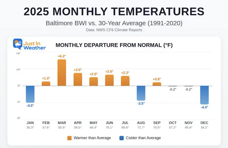
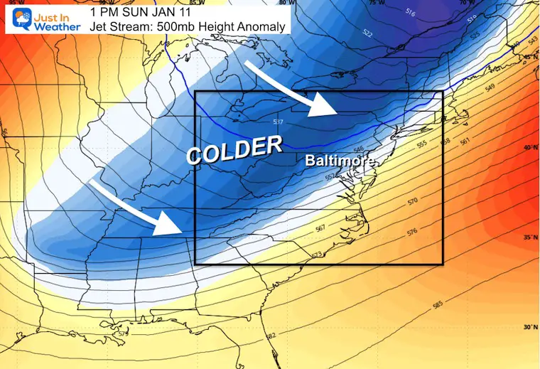
Our first weekend of the year will remain cold. We are currently running more than 5 degrees COLDER than average this month. The week ahead will qualify as the January thaw with many days reaching the 50s to near 60F.
Our region has been below average for most of the last 5 months, since August. So talking about a warm-up was inevitable, or a little balance. However, the signal is that winter will be reloading and making a return by mid-month.
Climate Report: Baltimore Temperatures 2025
Lake Effect Snow Video
Close to 80 inches of snow this past week North of Syracuse. That’s more than 6 Feet!
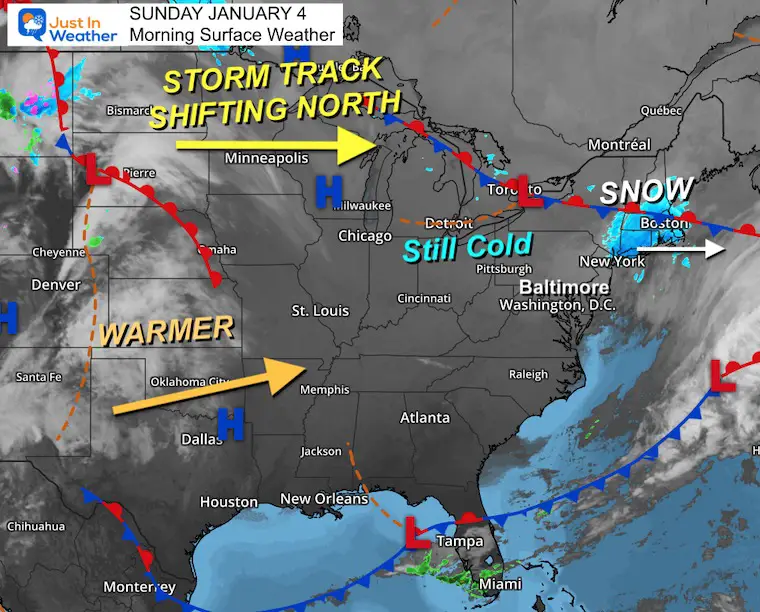
Morning Surface Weather
One more cold day today, then the warming trend begins. The pattern change is underway!
- Snow to Our North: New England, especially Boston, is seeing snow from a departing coastal system.
- Still Cold: Baltimore and the Mid-Atlantic remain in the cold air mass for now, but change is coming.
- Storm Track Shifting North: The main jet stream and storm track are lifting northward across Canada.
- Warmer Air Building: A surge of warmer air is pushing northeast from Texas/Oklahoma toward the Mid-Atlantic — this will arrive mid-week for our January thaw.
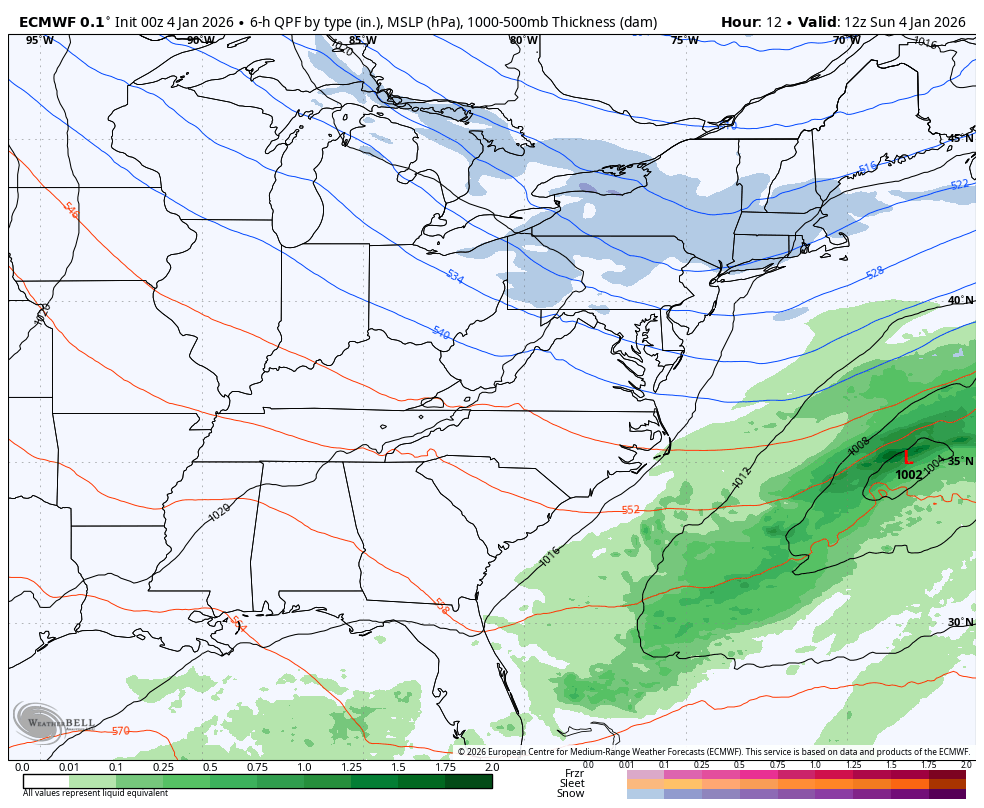
Storm Forecast Outlook
Sunday Morning To Wednesday
The next weather system will track to our north and signal the change of the weather pattern that will allow warmer air to flow our way.
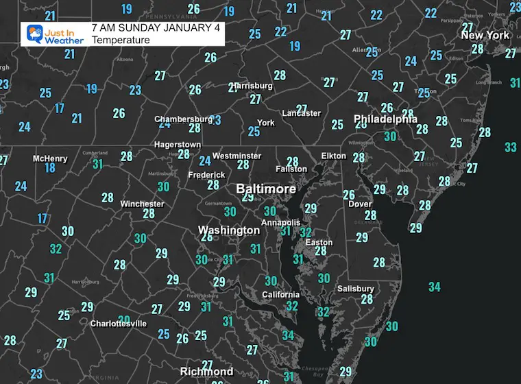
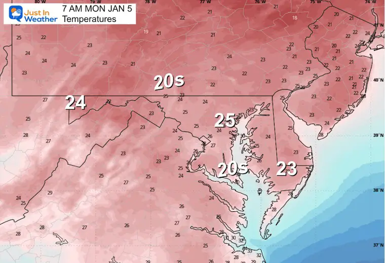
Morning Temperatures
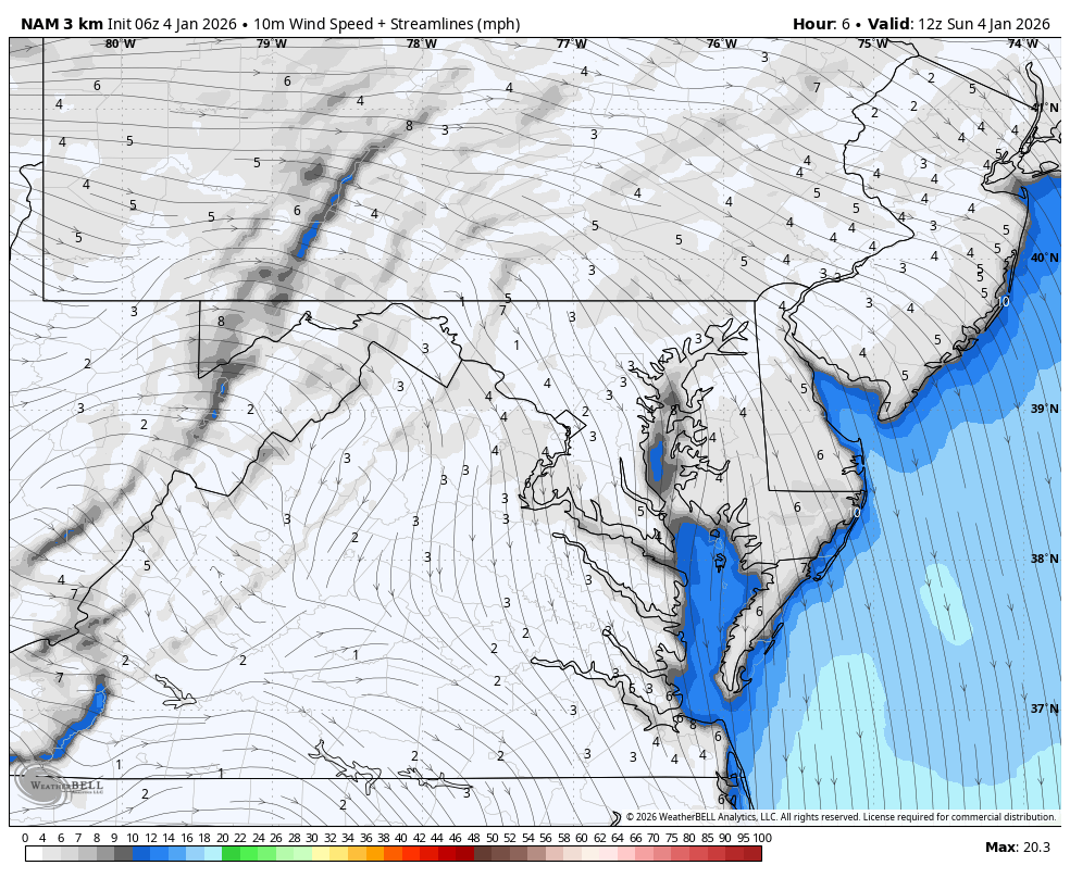
Wind Forecast
Gusts 15 to 20 mph
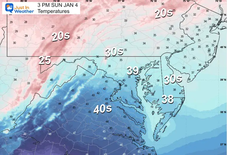
AFTERNOON Temperatures
LIVE RADAR WIDGET
MOUNTAIN CAM:
WESTERN MARYLAND
Wisp Ski Report: Snow To Date = 44 inches.
Wind is still in full force in this region. A fresh coating to few inches of snow has blanketed the region.
This webcam is positioned at The Greene Turtle Deep Creek Lake and shows Wisp Resort, including a zoomed-in view of Squirrel Cage, The Face, the terrain park, Boulder, the mountain coaster, the tubing park, and a shot of McHenry Cove at Deep Creek Lake!
CLIMATE DATA: Baltimore
Yesterday: Low 24°F; High 35°F
Precipitation: 0.00″
Season Snow Total: 2.0″
Snow Depth: 0″
Top Wind Gust: 15 mph
TODAY January 4
Sunrise at 7:26 AM
Sunset at 4:57 PM
Normal Low in Baltimore: 26ºF
Record Low: 4ºF in 1918
Normal High in Baltimore: 44ºF
Record High: 70ºF in 1950 & 2000
Rainfall Deficit at BWI
- Prior 2 Years (2024 + 2025) = -16.91″
- Since Jan 1, 2026 = -0.30″
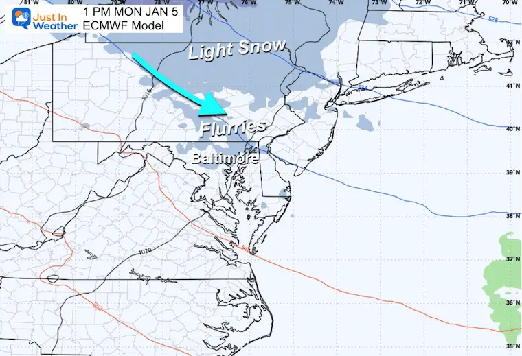
MONDAY
Morning Temperatures
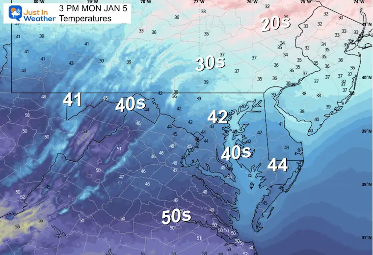
Afternoon Temperatures
Afternoon Snapshot
The last impulse before the change…
Flurries may reach Central to Northeastern Maryland… and Southern Pennsylvania.
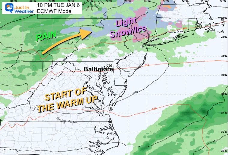
Tuesday
This impulse will track north with light snow or ice in the Poconos and rain into western Pennsylvania, signaling the warm-up to follow.
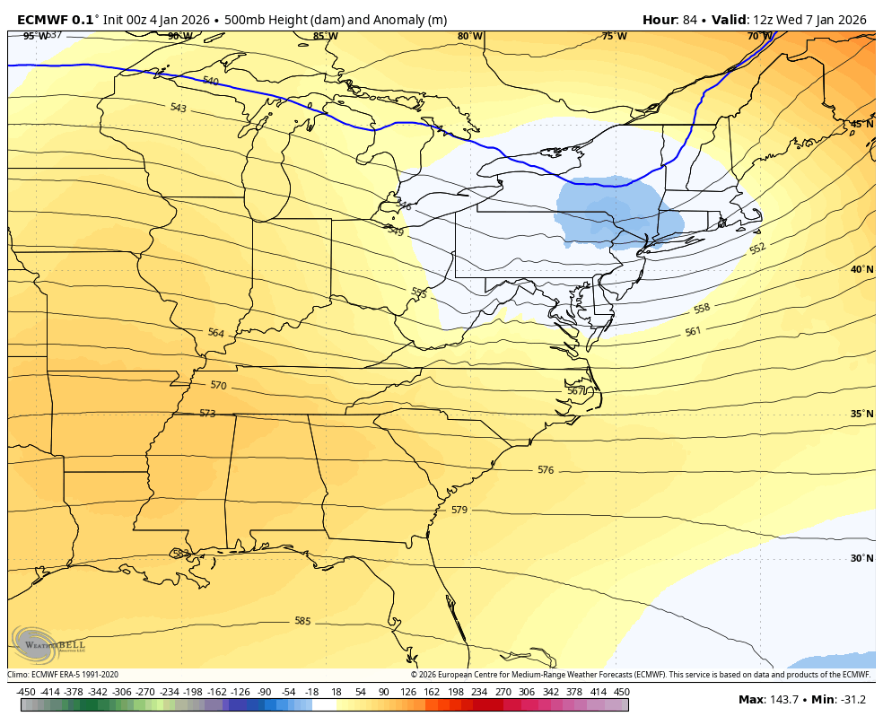
Jet Stream Wednesday to Sunday
Warmer air that has been the theme in the Central US so far this winter will reach the East Coast. This will be our January Thaw and allow temps to reach the mid 50s… perhaps one or two days could touch the 60s over the week ahead.
Snapshots
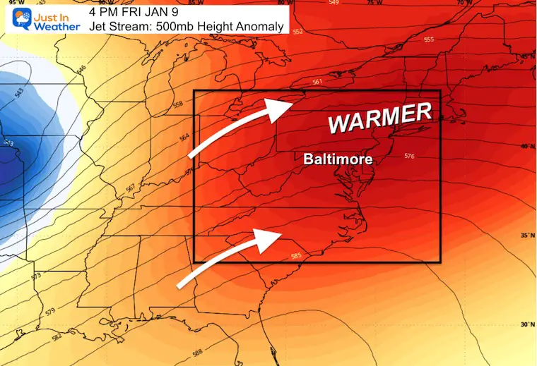
Friday:
The surge of warm air may be mitigated by clouds and the risk of rain. That will be the deciding factor on whether we reach the 60s or not.
Sunday:
The next cold front will be arriving. This may just bring us back closer to normal, but at least shows a breakdown of the ridge and a return to winter weather.
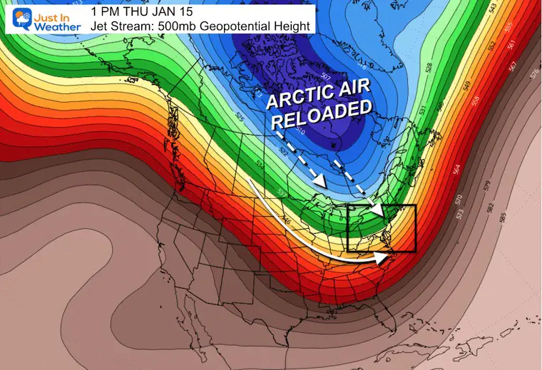
Looking Ahead: North American Jet Stream
Jan 10 to Jan 15
Arctic Air will be reloading. The build-up of cold air to return a flow favoring the Eastern part of North America is looking probable mid-month.
The block in the North Atlantic has been more persistent and more robust with influence than models have allowed. So I take the long-range outlooks with a grain of salt. There will be more cold air, and any hint of specifics with storms will not be handled well.
Again, I look for pattern changes, NOT locking in storms beyond one week.
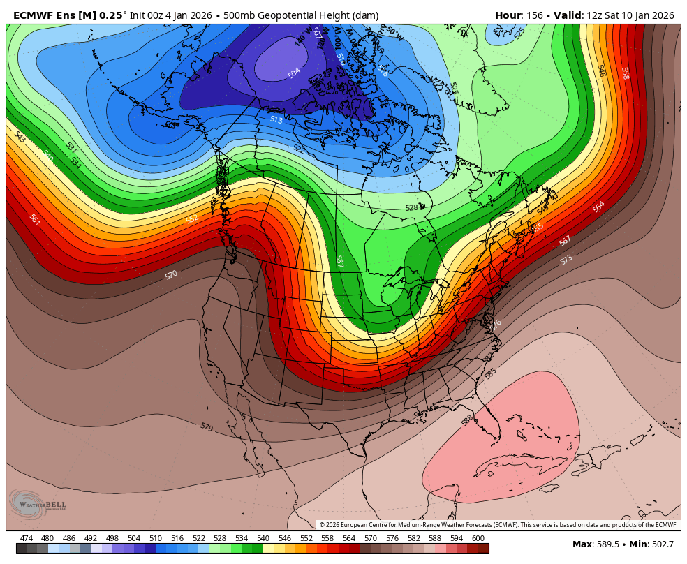
Snapshot Mid Month
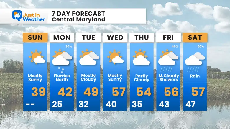
7-Day Forecast
That January Thaw shows up mid-week with highs in the mid-to-upper 50s.
- Sunday: Mostly sunny. High 39°F.
- Monday: Flurries north (30%). High 42°F, Low 25°F.
- Tuesday: Mostly cloudy. High 49°F, Low 32°F.
- Wednesday: Mostly sunny. High 57°F, Low 40°F.
- Thursday: Partly cloudy. High 54°F, Low 35°F.
- Friday: Mostly cloudy with showers (40%). High 56°F, Low 43°F.
- Saturday: Rain (60%). High 57°F, Low 47°F.
Subscribe for email Alerts
FAITH IN THE FLAKES STORE
NOW OPEN FOR THE SEASON
click here

Snow Report December 14 and Grade My Forecast
In case you missed it, click this image for brief summary of the final snow totals from the last event.

Snow Report December 5 to 6 and Grade My Forecast
In case you missed it, click this image for brief summary of the final snow totals from the last event.

My Winter Outlook For Above-Average Snow
Click here for the full report

La Niña Advisory
This was issued October 9, as expected: A weak and short-lived event to start winter may play a different role this winter.

In Case You Missed It
Woolly Bear Caterpillar Winter Folklore
These are NOT all the same caterpillar!

Winter Outlook From 2 Farmers’ Almanacs

STEM Assemblies/In School Fields Trips Are Back
Click to see more and ‘Book’ a visit to your school

THANK YOU:
Baltimore Sun Magazine Readers’ Choice Best Of Baltimore

Maryland Trek 12 Day 7 Completed Sat August 9
UPDATED: We raised OVER $170,000 for Just In Power Kids – AND Still Collecting More
The annual event: Hiking and biking 329 miles in 7 days between The Summit of Wisp to Ocean City.
Each day, we honor a kid and their family’s cancer journey.
Fundraising is for Just In Power Kids: Funding Free Holistic Programs. I never have and never will take a penny. It is all for our nonprofit to operate.
Click here or the image to donate:

RESTATING MY MESSAGE ABOUT DYSLEXIA
I am aware there are some spelling and grammar typos and occasional other glitches. I take responsibility for my mistakes and even the computer glitches I may miss. I have made a few public statements over the years, but if you are new here, you may have missed it: I have dyslexia and found out during my second year at Cornell University. It didn’t stop me from getting my meteorology degree and being the first to get the AMS CBM in the Baltimore/Washington region. One of my professors told me that I had made it that far without knowing and to not let it be a crutch going forward. That was Mark Wysocki, and he was absolutely correct! I do miss my mistakes in my own proofreading. The autocorrect spell check on my computer sometimes does an injustice to make it worse. I can also make mistakes in forecasting. No one is perfect at predicting the future. All of the maps and information are accurate. The ‘wordy’ stuff can get sticky. There has been no editor who can check my work while writing and to have it ready to send out in a newsworthy timeline. Barbara Werner is a member of the web team that helps me maintain this site. She has taken it upon herself to edit typos when she is available. That could be AFTER you read this. I accept this and perhaps proves what you read is really from me… It’s part of my charm. #FITF
Please share your thoughts and best weather pics/videos, or just keep in touch via social media.


