Conditions: Baltimore, Maryland, 01/04/2026 04:40:05 am
Temperature

30°

Cloudy

14°

Dew Point
Relative Humidity

51%

Feels Like

30°

Wind (N)

0mph

Air Pressure

30.03

Sun
Sun Rise

07:26 AM

Sun Set

04:57 PM

Day Length

09:31 Hours

Difference

0 min 51 sec gain

Moon
Moon Rise

06:29 PM

Moon Set

08:43 AM

Next: Last Quarter

Jan 10,2026

Moon Phase

Waning Gibbous

Climate
Average Low

25°

42°

Average High
Record Low


(1918)

70°


(2000)
Record High
Conditions

January 3 Supermoon Saturday Caught Cold Between Two Weather Systems Then Warm Up Next Week

Maryland Weather
climate data
Winter Weather
Forecast

Saturday, January 3, 2025

The Full Wolf Supermoon became official early this morning, but the clouds rolled back in. It was large and in charge rising yesterday, but odds are many missed seeing it this morning.

If you miss snow, wait until you see the first-hand account of Lake Effect Snow in Northern New York state, where 70 inches of snow fell in three days.

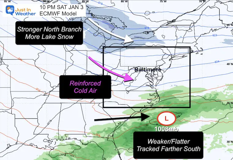
I want to restate that while I was watching the southern storm tracking north yesterday, it became clear that it would remain weaker and stay south as the stronger northern branch of the jet stream would dominate. The result is a colder weekend, and we will NOT be seeing these two phase or merge.

However, we get more clouds and maybe some flurries in between. Not a big deal.

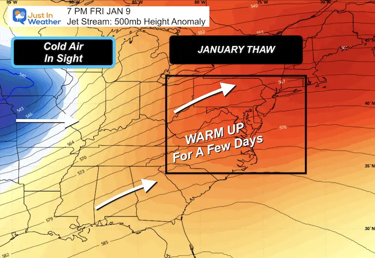
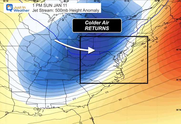
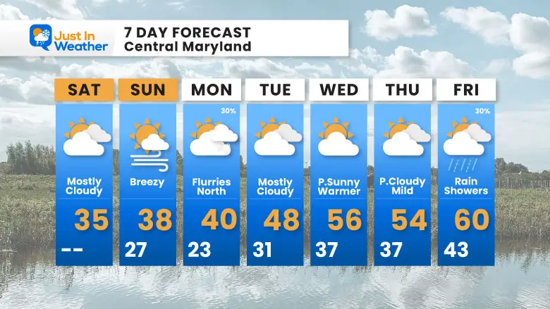
The overall pattern will be relaxing in the week ahead. After such a cold December, a January thaw is common and will most likely give way to the return of the cold mid-month.

There will be one more system that could bring some flurries or light snow to the north, then we may push the 60s by next weekend, before the cold air returns.

From Social Media

Full Wolf Supermoon


Lake Effect Snow: First Hand Account

70 inches of snow in Three Days, North of Syracuse.

Morning Surface Weather

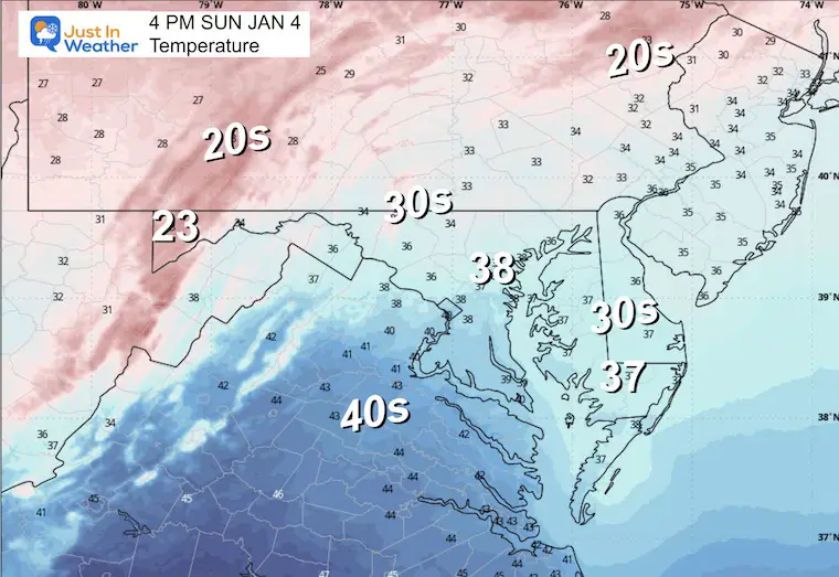
Baltimore and the Mid-Atlantic are caught between two storm tracks today:

  • Northern Track: A stronger system is pushing south from Canada through the Great Lakes region toward the Northeast.
  • Southern Track: A “flat” storm track is staying south, moving off the Carolina coast and out to sea.

The Result: The Mid-Atlantic sits in between these two systems, leaving us cloudy with the chance for flurries — but missing out on any significant precipitation from either storm.


January 3 weather map Saturday morning

Storm Forecast Outlook

Saturday Night to Tuesday Night

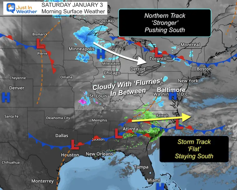
After this weak system passes off the Carolina Coast, the intrusion of cold air will bring one more clipper light snow to Pennsylvania and may clip Northeastern Maryland.

Then the next storm track brings light ice and snow to our north…. beginning our January Thaw warmup.

January 3 weather storm forecast


Morning Temperatures

January 3 weather temperatures Saturday morning


LIVE RADAR WIDGET

MOUNTAIN CAM:

WESTERN MARYLAND

Wind is still in full force in this region. A fresh coating to few inches of snow has blanketed the region.

This webcam is positioned at The Greene Turtle Deep Creek Lake and shows Wisp Resort, including a zoomed-in view of Squirrel Cage, The Face, the terrain park, Boulder, the mountain coaster, the tubing park and a shot of McHenry Cove at Deep Creek Lake!

AFTERNOON: Temperatures

January 3 weather temperatures Saturday afternoon


Saturday Night Snapshot

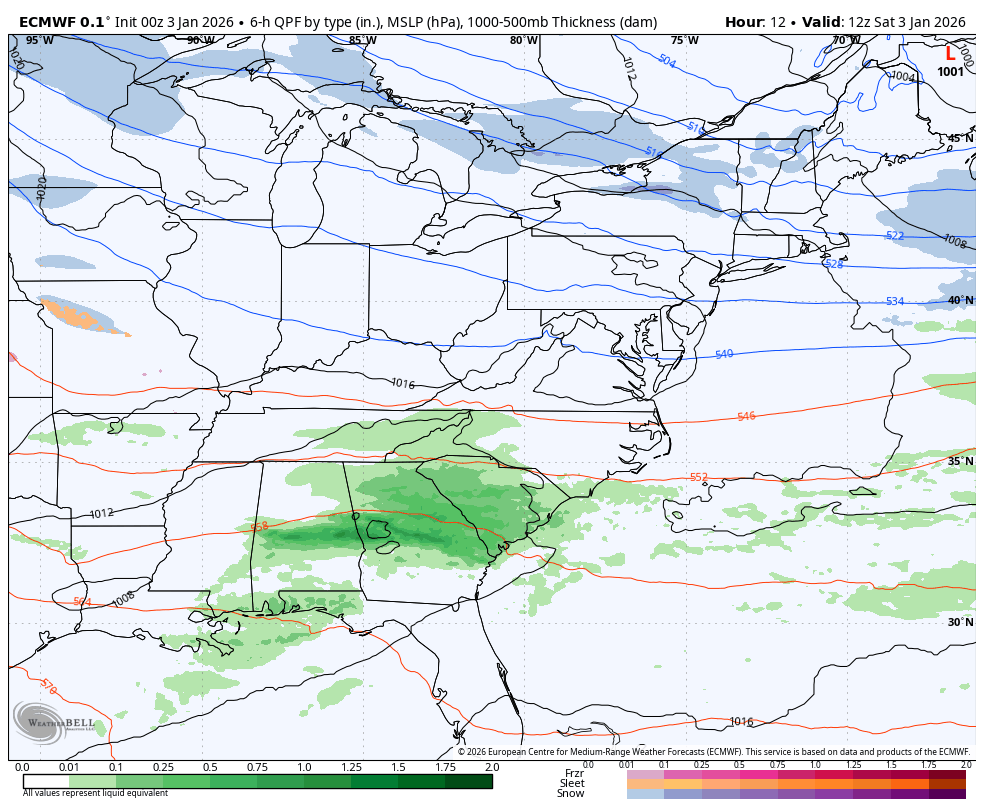
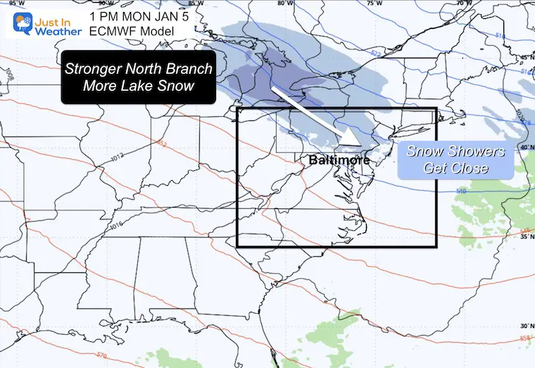
(10 PM – ECMWF Model)

The two-track pattern continues tonight:

  • Northern Branch: Stronger system bringing more lake effect snow to the Great Lakes region, while pushing reinforced cold air into the Mid-Atlantic.
  • Southern Coastal Low: Weaker and flatter, tracking farther south off the Carolina coast — staying away from our region.

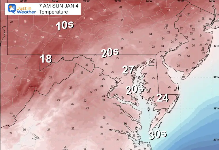
For Baltimore: The coastal low missing us to the south means we stay dry, but the reinforced cold air from the northern branch keeps the cold temperatures locked in.


January 3 weather outlook Tonight snow

CLIMATE DATA: Baltimore

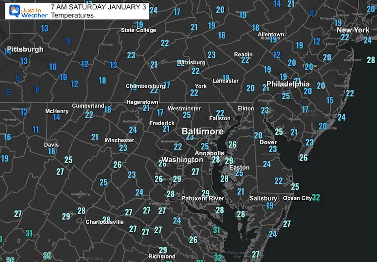
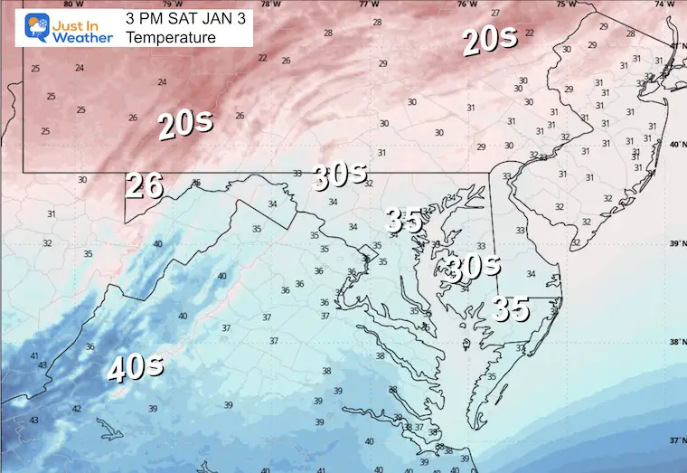
Yesterday: Low 24°F; High 37°F

Precipitation: Trace

Season Snow Total: 2.0″

Snow Depth: 0″

Top Wind Gust: 14 mph

TODAY January 3

Sunrise at 7:26 AM

Sunset at 4:56 PM

Normal Low in Baltimore: 27ºF

Record Low: 0ºF in 1879

Normal High in Baltimore: 44ºF

Record High: 69ºF in 2023

Rainfall Deficit at BWI

  • Prior 2 Years (2024 + 2025) = -16.91″
  • Since Jan 1, 2026 = -0.20″

SUNDAY

Morning Temperatures

January 3 weather temperatures Sunday morning


Wind Forecast

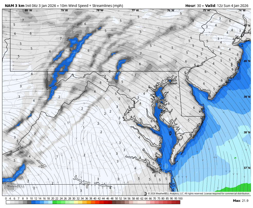
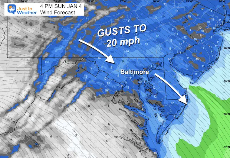
We miss the storm, but get wind as the cold air gets one more reinforcement.

January 3 weather wind forecast Sunday


Afternoon Wind Snapshot

January 3 weather wind forecast Sunday afternoon

Afternoon  Temperatures

January 3 weather temperatures Sunday afternoon

Focus Ahead

Monday Afternoon Storm Outlook (1 PM – ECMWF Model)

  • Northern Branch: Still the stronger player, continuing to produce lake effect snow across the Great Lakes and into the Northeast.
  • For Baltimore: Snow showers get close! The northern branch pushes snow showers toward the Mid-Atlantic, with the best chance staying to our north. However, some flurries may clip the region — especially northern Maryland and Southern Pennsylvania.


January 3 weather forecast snow Monday


Tuesday Evening Storm Outlook (7 PM – ECMWF Model)

  • Pattern Change: The storm track shifts north, taking systems across the Great Lakes and into Canada/New England.
  • For Baltimore: Warmer air flows in for a few days! With the storm track lifting north, milder air from the south gets a chance to move into the Mid-Atlantic region.
  • Rain Chance: Some showers may approach from the west, but the main action stays to our north.

January 3 weather forecast rain warm Tuesday


Jet Stream Forecast: Tuesday to Sunday

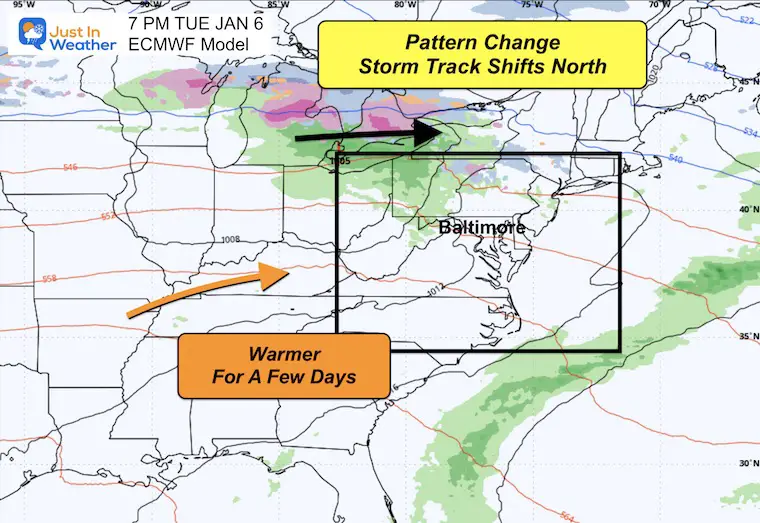
Tracking the warm up and then the next push of cold air.

January 3 weather jet stream Forecast

Snapshots

Next Friday Jet Stream Outlook (7 PM – 500mb Height Anomaly)

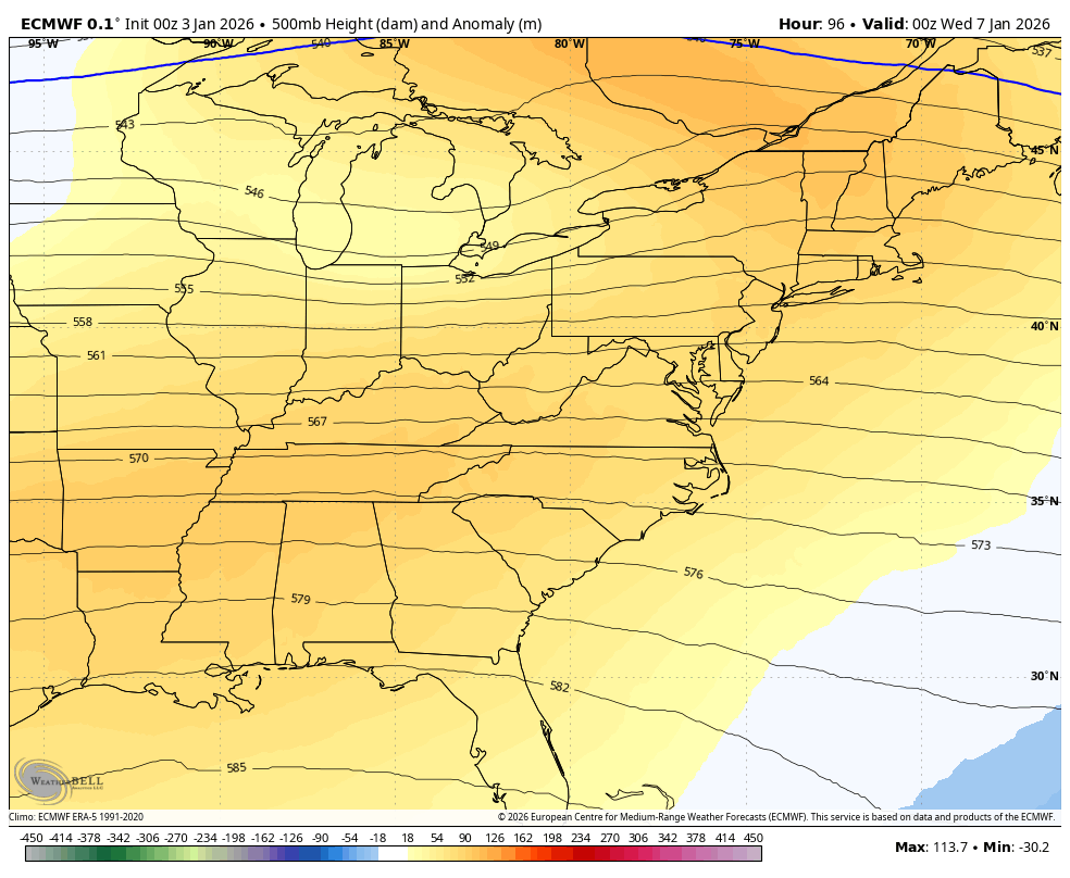
A nice mid-winter breather before winter fights back!

  • January Thaw: Warmer air dominates the eastern U.S. with a warm-up for a few days across the Mid-Atlantic.
  • For Baltimore: Riding the warm side of the pattern — expect temperatures to climb well above normal, with highs near 60°F by Friday.
  • But… Cold air is in sight! A cold air mass building in the northern Plains signals this thaw won’t last. Another arctic intrusion is likely on the way after this brief break.

January 3 weather jet stream Forecast Friday


Sunday, January 11 Jet Stream Outlook (1 PM – 500mb Height Anomaly)

The January roller coaster continues — enjoy the mild days while they last!

  • Colder Air Returns: The January Thaw is short-lived! A trough digs into the eastern U.S., bringing colder air back to the Mid-Atlantic.
  • For Baltimore: The warm-up ends as the cold air mass pushes through. Expect temperatures to drop back below normal heading into the following week.
  • Pattern Watch: This setup could support another active period with potential for winter weather as systems interact with the returning cold air.

January 3 weather jet stream Forecast Sunday


7-Day Forecast

  • Saturday: Mostly cloudy. High 35°F.
  • Sunday: Breezy. High 38°F, Low 27°F.
  • Monday: Flurries north (30%). High 40°F, Low 23°F.
  • Tuesday: Mostly cloudy. High 48°F, Low 31°F.
  • Wednesday: Partly sunny, warmer. High 56°F, Low 37°F.
  • Thursday: Partly cloudy, mild. High 54°F, Low 37°F.
  • Friday: Rain showers (30%). High 60°F, Low 43°F.


January 3 weather forecast 7 day Saturday


Subscribe for email Alerts

Weather posts straight to your inbox

Sign up and be the first to know!


FAITH IN THE FLAKES STORE

NOW OPEN FOR THE SEASON

click here


Snow Report December 14  and Grade My Forecast

In case you missed it, click this image for brief summary of the final snow totals from the last event.

December 14 weather snow total Sunday

Snow Report December 5 to 6 and Grade My Forecast

In case you missed it, click this image for brief summary of the final snow totals from the last event.

December 6 weather snow analysis preliminary


My Winter Outlook For Above-Average Snow

Click here for the full report

Winter 2025 to 2026 My Call for Suggested Snowfall


La Niña Advisory

This was issued October 9, as expected: A weak and short-lived event to start winter may play a different role this winter.

October 9 La Nina Advisory map Pacific Ocean

In Case You Missed It

Woolly Bear Caterpillar Winter Folklore

These are NOT all the same caterpillar!

Woolly Bear Caterpillars And Imposters For Winter Weather Folklore


Winter Outlook From 2 Farmers’ Almanacs

Winter Outlooks 2025 to 2026 Two Farmers Almanacs


STEM Assemblies/In School Fields Trips Are Back

Click to see more and ‘Book’ a visit to your school

THANK YOU:

Baltimore Sun Magazine Readers’ Choice Best Of Baltimore

Best of Baltimore 2025 Meteorologist Justin Berk

Maryland Trek 12 Day 7 Completed Sat August 9

UPDATED: We raised OVER $170,000 for Just In Power Kids – AND Still Collecting More

The annual event: Hiking and biking 329 miles in 7 days between The Summit of Wisp to Ocean City.

Each day, we honor a kid and their family’s cancer journey.

Fundraising is for Just In Power Kids: Funding Free Holistic Programs. I never have and never will take a penny. It is all for our nonprofit to operate.


Click here or the image to donate:

Maryland Trek 12 Finish August 9 2025

RESTATING MY MESSAGE ABOUT DYSLEXIA

I am aware there are some spelling and grammar typos and occasional other glitches. I take responsibility for my mistakes and even the computer glitches I may miss. I have made a few public statements over the years, but if you are new here, you may have missed it: I have dyslexia and found out during my second year at Cornell University. It didn’t stop me from getting my meteorology degree and being the first to get the AMS CBM in the Baltimore/Washington region. One of my professors told me that I had made it that far without knowing and to not let it be a crutch going forward. That was Mark Wysocki, and he was absolutely correct! I do miss my mistakes in my own proofreading. The autocorrect spell check on my computer sometimes does an injustice to make it worse. I can also make mistakes in forecasting. No one is perfect at predicting the future. All of the maps and information are accurate. The ‘wordy’ stuff can get sticky.  There has been no editor who can check my work while writing and to have it ready to send out in a newsworthy timeline. Barbara Werner is a member of the web team that helps me maintain this site. She has taken it upon herself to edit typos when she is available. That could be AFTER you read this. I accept this and perhaps proves what you read is really from me… It’s part of my charm. #FITF

Please share your thoughts and best weather pics/videos, or just keep in touch via social media.