Wednesday, December 31, 2025
If I had to ask you for the weather highlight of the year and how it might end, my guess is the majority of people would say WIND! Well, we had one system pass early this morning with a burst of light snow.
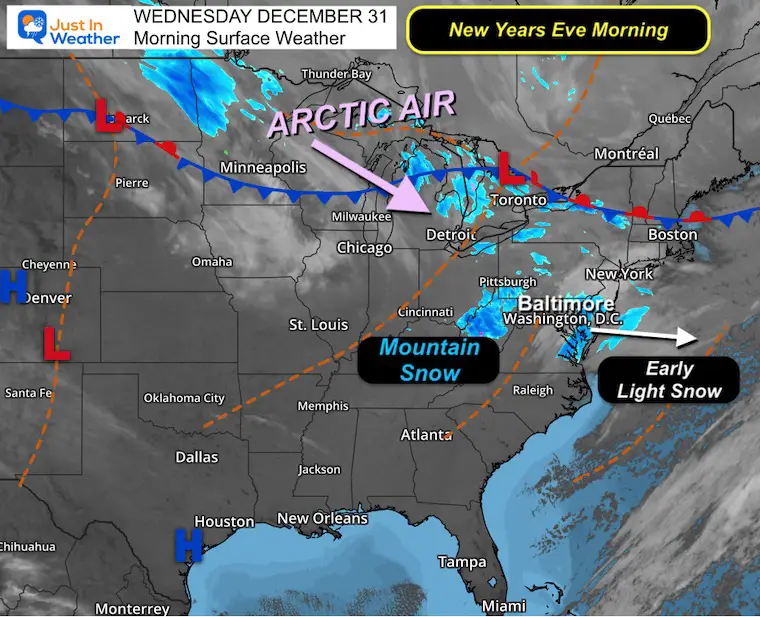
Today will be tame for most of us, while snow continues in the mountains. There is one more push of snow expected as an arctic front arrives to ring in the New Year, a few hours later.
So any plans tonight will be fine at midnight. Then, before sunrise, an arctic front will bring a snow squall line with gusty winds, which will bring a fresh air mass and much colder temperatures our way for New Year’s Day.
In Case You Missed It: Early Morning Snow
This verified the updates I posted on social media yesterday. It may not have produced more than a light coating in some areas, but it was noticeable.
Radar Animation
Morning Surface Weather
The band of light snow passed through about an hour earlier than models suggested. This will be off the coast now, while steady snow will persist in the Winter Storm Warning area of Western Maryland.
Morning Temperatures

LIVE RADAR WIDGET
MOUNTAIN CAM:
WESTERN MARYLAND
Wind is still in full force in this region. A fresh coating to a few inches of snow has blanketed the region.
This webcam is positioned at The Greene Turtle Deep Creek Lake and shows Wisp Resort, including a zoomed-in view of Squirrel Cage, The Face, the terrain park, Boulder, the mountain coaster, the tubing park and a shot of McHenry Cove at Deep Creek Lake!
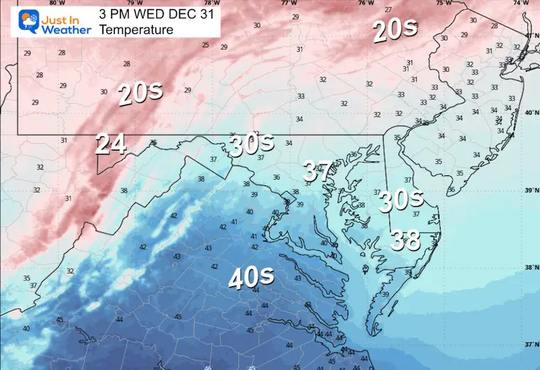
Afternoon Temperatures
NEW YEAR’S EVE
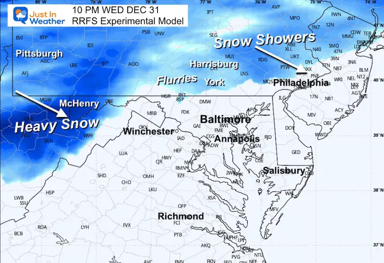
Radar Simulation
Snow in the mountains AND in Pennsylvania. There may be flurries or light snow in Southern Pennsylvania near Harrisburg, York, and Lancaster.
Midnight Temperatures

CLIMATE DATA: Baltimore
Yesterday: Low 25°F; High 36°F
Precipitation: 0.00″
Season Snow Total: 2.0″
Snow Depth: 0″
Top Wind Gust: 47 mph
TODAY December 31
Sunrise at 7:26 AM
Sunset at 4:54 PM
Normal Low in Baltimore: 27ºF
Record Low: -1ºF in 1880
Normal High in Baltimore: 44ºF
Record High: 72ºF in 1992
Rainfall Deficit at BWI
- Ending 2024 = -8.00″
- Since Jan 1 = -8.91″
- We are STILL DOWN -16.91″ INCLUDING LAST YEAR
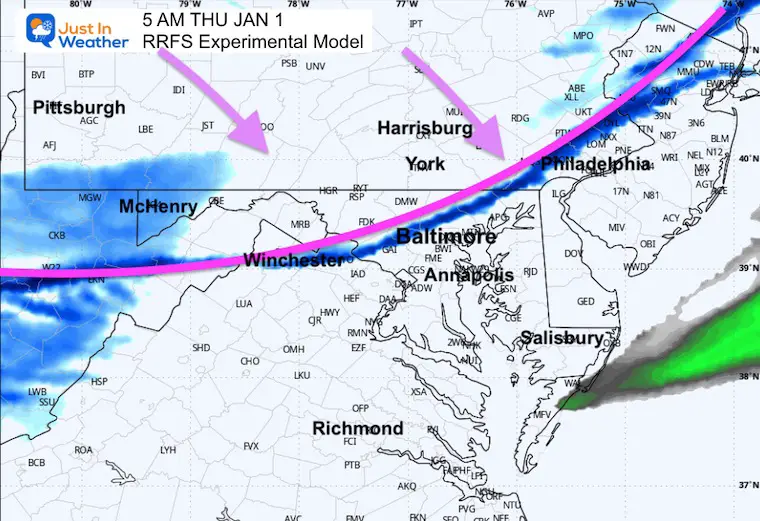
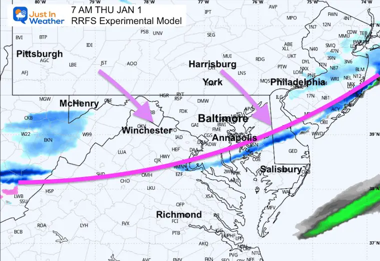
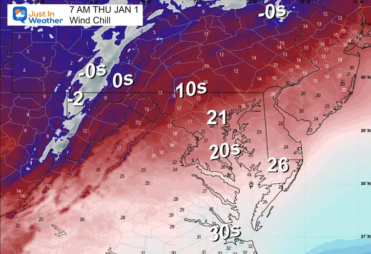
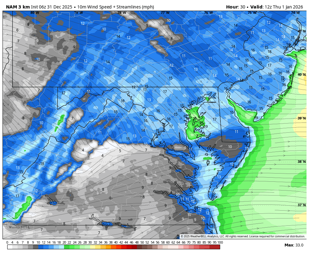
NEW YEAR’S DAY: THURSDAY
The Arctic front will arrive before sunrise. This will bring a squall line with brief heavy snow and gusty winds. Then the temps will hold in the cold all day.
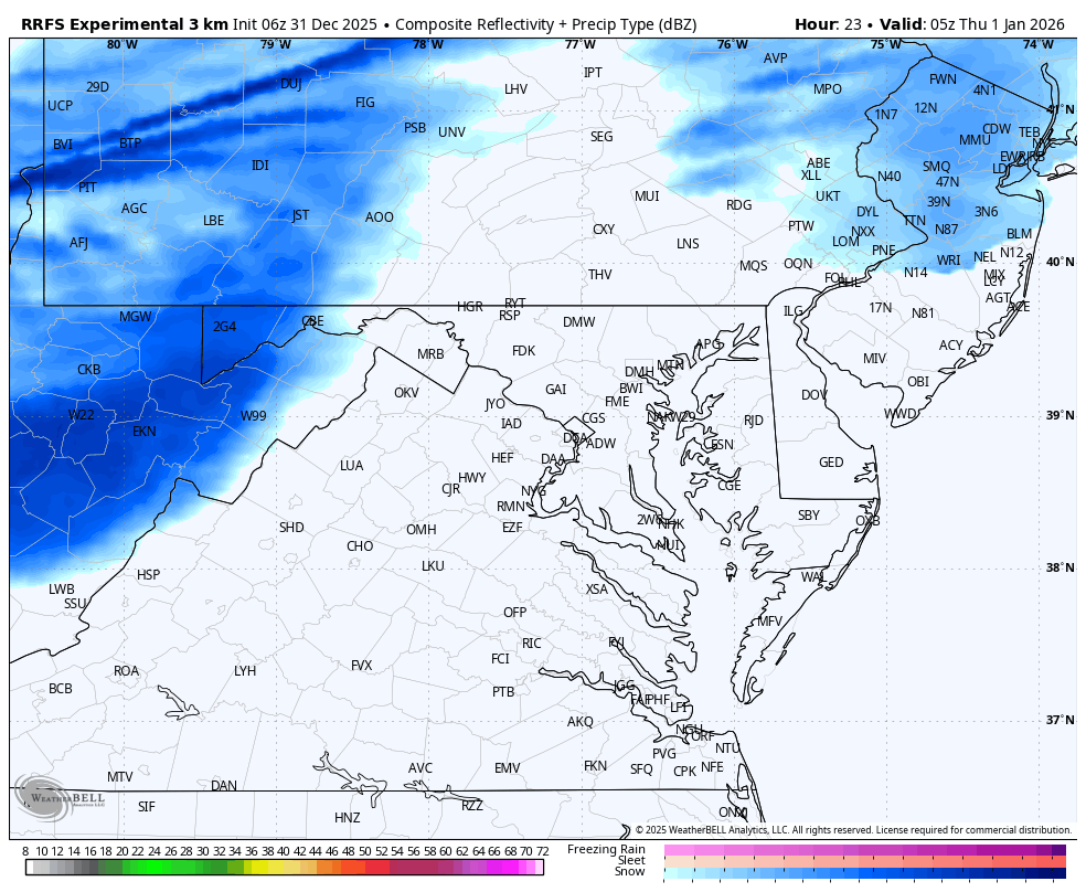
Radar Simulation: Midnight to Noon
5 AM Snapshot
7 AM Snapshot
Morning Temperatures

Morning Wind Chills
Morning Wind

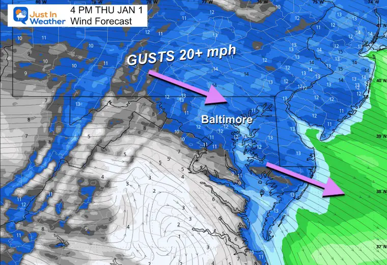
Wind Forecast 7 AM to Midnight
Afternoon Wind
Afternoon Temperatures

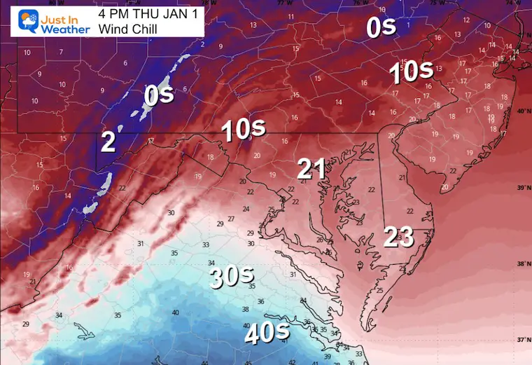
Afternoon Wind Chills
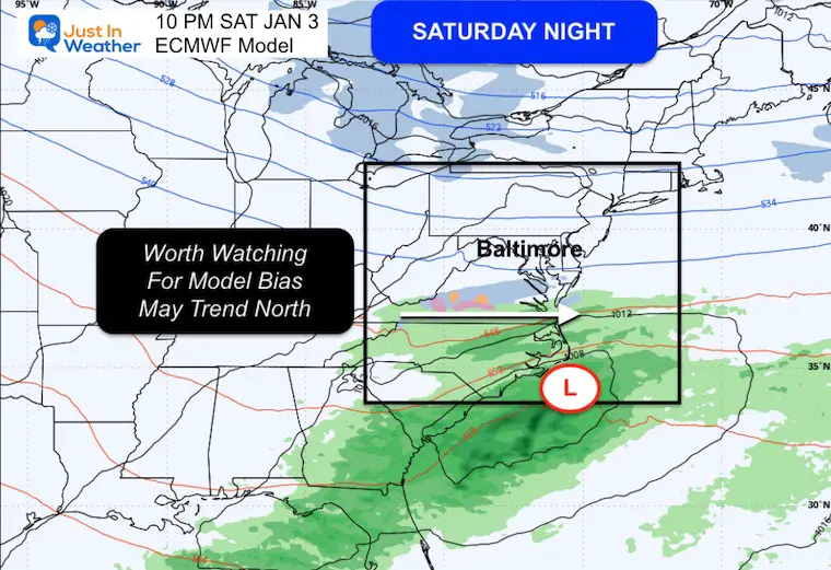
Weekend Focus
In the cold air, we will have a split aloft. This is currently showing a southern track system on Saturday night.
North: Lake Effect Snow
South: Low Pressure moving off the Carolina Coast.
There has been a bias with systems verifying a little north, like last weekend. Any kink northward could bring light snow into Southern Maryland…
So this is just in the ‘paying attention’ mode for now.
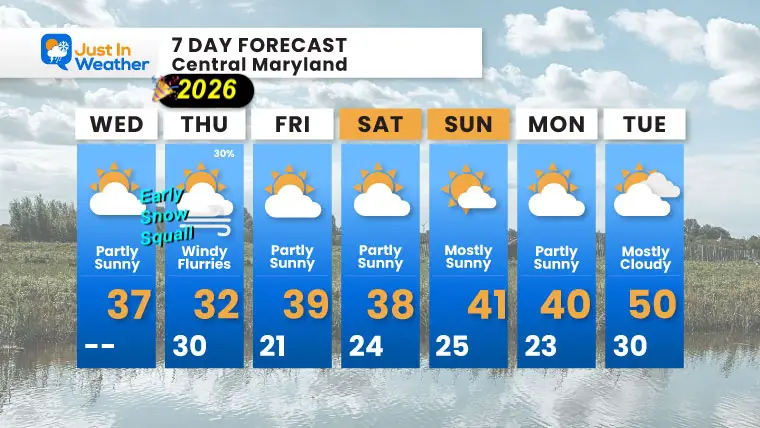
7-Day Forecast
- Wednesday (New Year’s Eve): Partly sunny. High 37°F.
- Thursday (New Year’s Day): Early snow squall possible (30%), windy with flurries. High 32°F, Low 30°F.
- Friday: Partly sunny. High 39°F, Low 21°F.
- Saturday: Partly sunny. High 38°F, Low 24°F.
- Sunday: Mostly sunny. High 41°F, Low 25°F.
- Monday: Partly sunny. High 40°F, Low 23°F.
- Tuesday: Mostly cloudy. High 50°F, Low 30°F.
Subscribe for email Alerts
FAITH IN THE FLAKES STORE
NOW OPEN FOR THE SEASON
click here

Snow Report December 14 and Grade My Forecast
In case you missed it, click this image for brief summary of the final snow totals from the last event.

Snow Report December 5 to 6 and Grade My Forecast
In case you missed it, click this image for brief summary of the final snow totals from the last event.

My Winter Outlook For Above-Average Snow
Click here for the full report

La Niña Advisory
This was issued October 9, as expected: A weak and short-lived event to start winter may play a different role this winter.

In Case You Missed It
Woolly Bear Caterpillar Winter Folklore
These are NOT all the same caterpillar!

Winter Outlook From 2 Farmers’ Almanacs

STEM Assemblies/In School Fields Trips Are Back
Click to see more and ‘Book’ a visit to your school

THANK YOU:
Baltimore Sun Magazine Readers’ Choice Best Of Baltimore

Maryland Trek 12 Day 7 Completed Sat August 9
UPDATED: We raised OVER $170,000 for Just In Power Kids – AND Still Collecting More
The annual event: Hiking and biking 329 miles in 7 days between The Summit of Wisp to Ocean City.
Each day, we honor a kid and their family’s cancer journey.
Fundraising is for Just In Power Kids: Funding Free Holistic Programs. I never have and never will take a penny. It is all for our nonprofit to operate.
Click here or the image to donate:

RESTATING MY MESSAGE ABOUT DYSLEXIA
I am aware there are some spelling and grammar typos and occasional other glitches. I take responsibility for my mistakes and even the computer glitches I may miss. I have made a few public statements over the years, but if you are new here, you may have missed it: I have dyslexia and found out during my second year at Cornell University. It didn’t stop me from getting my meteorology degree and being the first to get the AMS CBM in the Baltimore/Washington region. One of my professors told me that I had made it that far without knowing and to not let it be a crutch going forward. That was Mark Wysocki, and he was absolutely correct! I do miss my mistakes in my own proofreading. The autocorrect spell check on my computer sometimes does an injustice to make it worse. I can also make mistakes in forecasting. No one is perfect at predicting the future. All of the maps and information are accurate. The ‘wordy’ stuff can get sticky. There has been no editor who can check my work while writing and to have it ready to send out in a newsworthy timeline. Barbara Werner is a member of the web team that helps me maintain this site. She has taken it upon herself to edit typos when she is available. That could be AFTER you read this. I accept this and perhaps proves what you read is really from me… It’s part of my charm. #FITF
-
Please share your thoughts and best weather pics/videos, or just keep in touch via social media.


