Tuesday, December 30, 2025
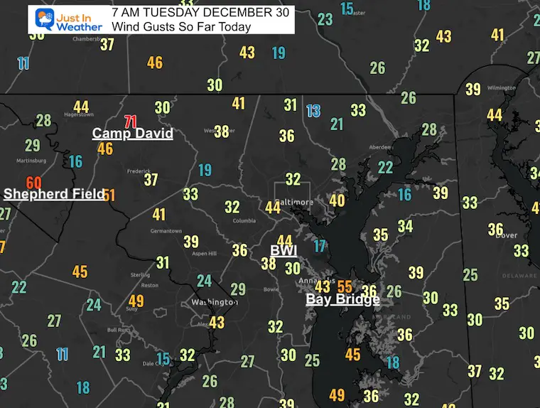
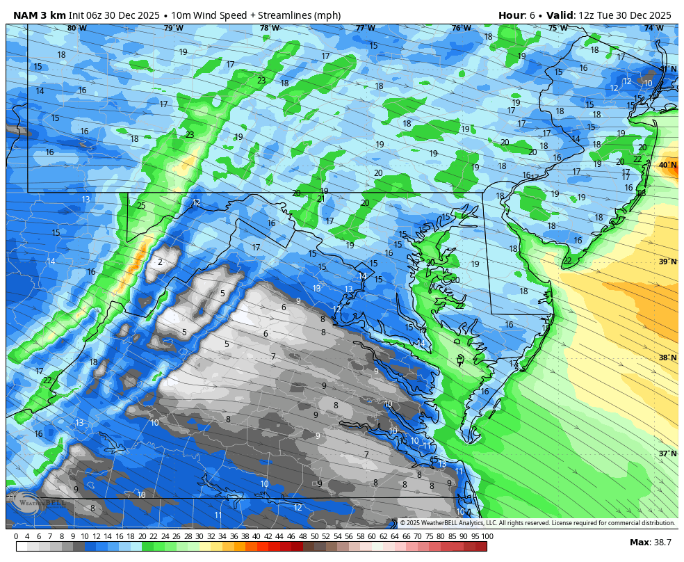
All the attention to the wind lived up to expectations. Many areas in our region exceeded 60 mph, which included both mountain locations and even BWI airport yesterday. This morning, Camp David already popped at 71 mph!
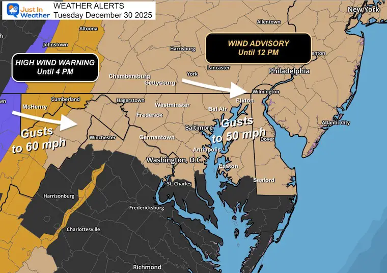
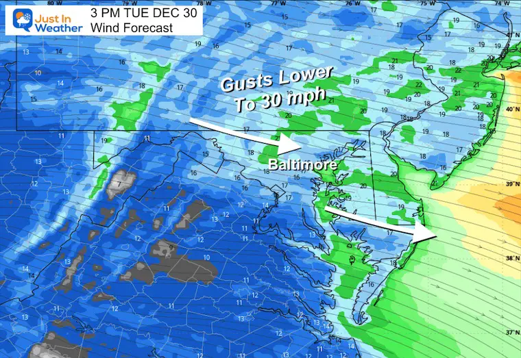
A Wind Advisory remains in effect today through Noon. The wind will not stop, but it will be less intense during the afternoon.
Morning Wind Gusts As of 7 AM
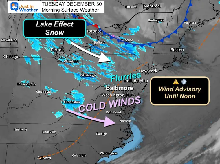
With the cold and unstable air, some flurries and snow showers have reached our region. A few more impulses will keep some confetti flakes around through New Year’s Day, and some areas may get a coating of snow.
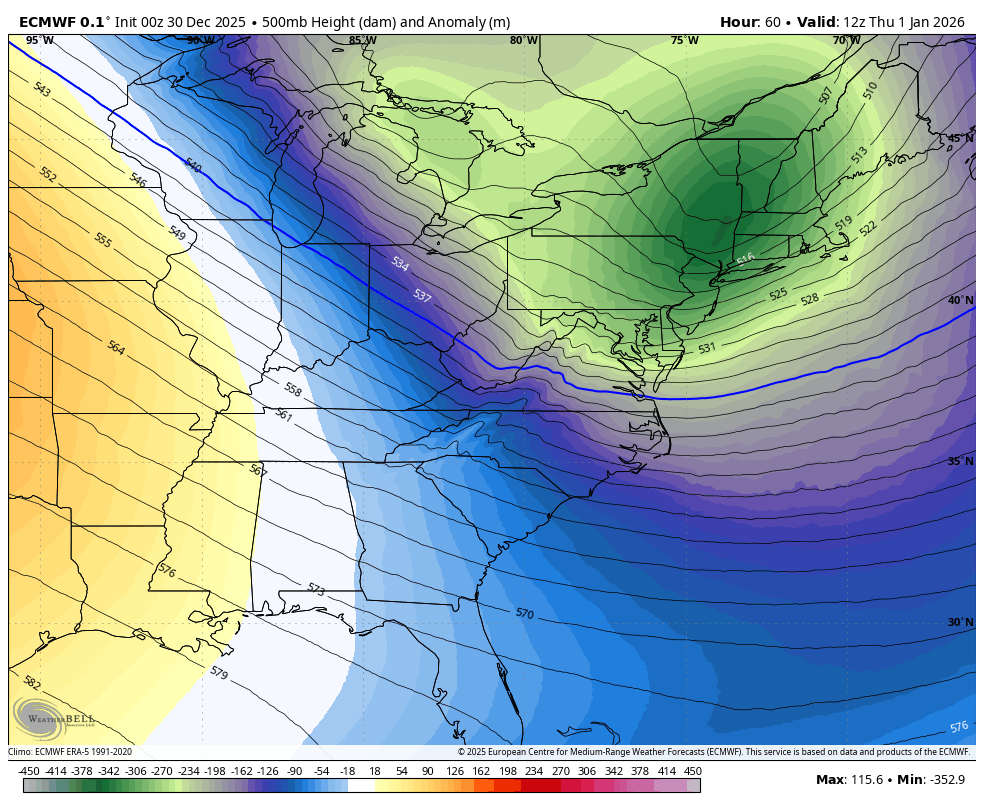
Looking Ahead: The overall pattern into January supports more cold and perhaps a storm or two along the East Coast in the middle of the month.
In case you missed it: Top Winds Yesterday
Sabillasville/Camp David hit 68 mph
BWI hit 61 mph
See my post on Facebook for the full list of top winds across the region.
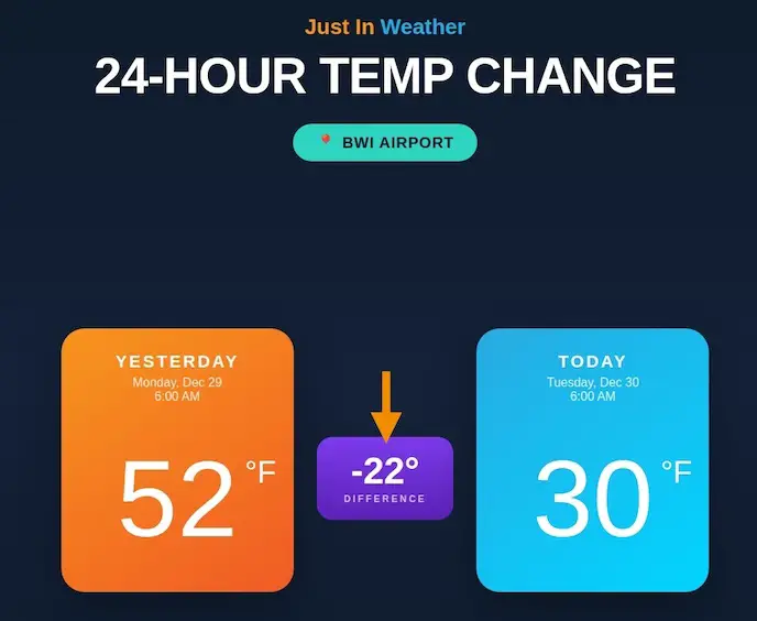
24 Hour Temperature Change
The other highlight is the change in temperatures. This morning, there is a noticeable drop of 22 degrees in 24 hours.
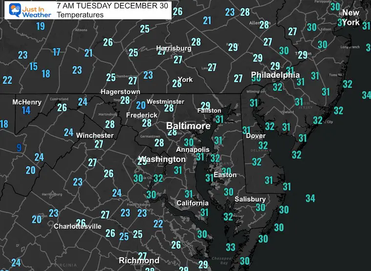
Morning Temperatures
Weather Alerts
- Wind Advisory: Until Noon
- High Wind Warning AND Winter Weather Advisory: Until 4 PM
Wind Forecast 7 AM to Midnight
Morning Surface Weather
We remain under the influence of this cold and windy pattern flowing across the Great Lakes. This will keep the air unsettled with periods of clouds and flurries or snow showers… especially inland North and West of the cities.
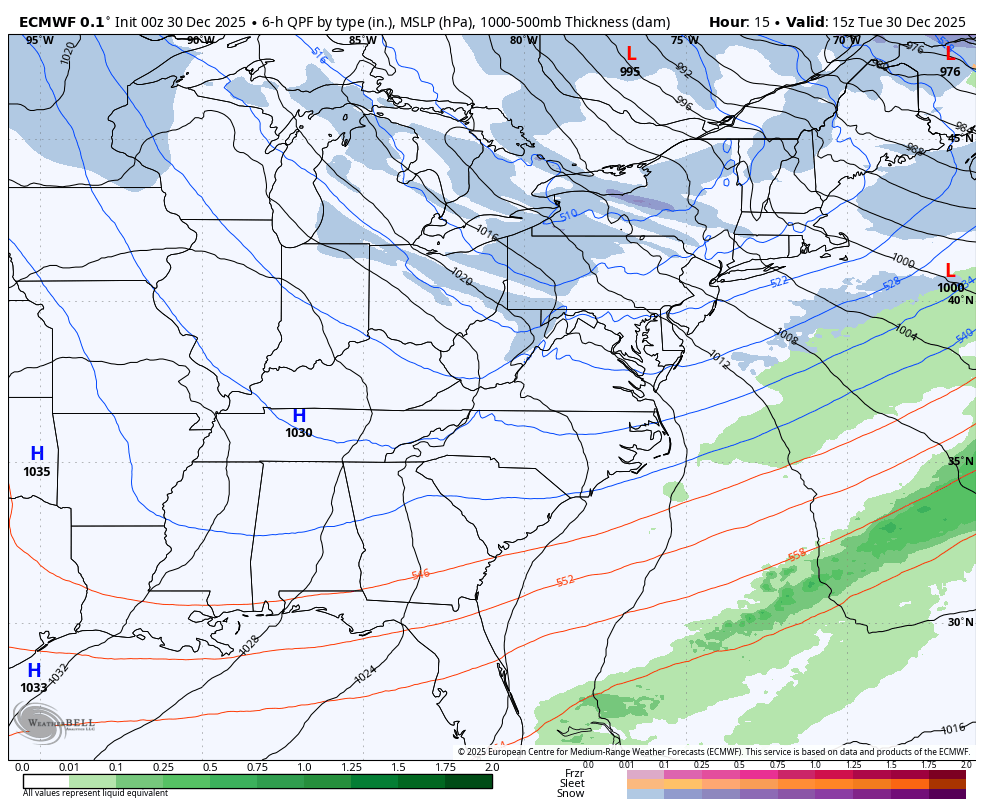
Storm Forecast: Today through Thursday Morning
Tracking the potential for flurries or light snow.
LIVE RADAR WIDGET
This is not color-coded for snow, but there may be snow flurries or snow showers reaching parts of Northern Maryland and Southern PA.
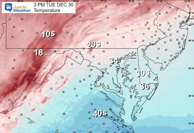
AFTERNOON:
Temperatures
Wind Forecast
Wind Chills

MOUNTAIN CAM:
WESTERN MARYLAND
Wind is still in full force in this region. A fresh coating of a few inches of snow has blanketed the region.
This webcam is positioned at The Greene Turtle Deep Creek Lake and shows Wisp Resort, including a zoomed-in view of Squirrel Cage, The Face, the terrain park, Boulder, the mountain coaster, the tubing park and a shot of McHenry Cove at Deep Creek Lake!
CLIMATE DATA: Baltimore
Yesterday: Low 31°F; High 57°F
Precipitation: 0.01″
Season Snow Total: 2.0″
Snow Depth: 0″
Top Wind Gust: 60 mph
TODAY December 30
Sunrise at 7:26 AM
Sunset at 4:53 PM
Normal Low in Baltimore: 27ºF
Record Low: -3ºF in 1880
Normal High in Baltimore: 44ºF
Record High: 68ºF in 1990
Rainfall Deficit at BWI
- Ending 2024 = -8.00″
- Since Jan 1 = -8.81″
- We are STILL DOWN -16.81″ INCLUDING LAST YEAR
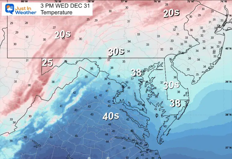
WEDNESDAY
Cold air will be fully established as gusty winds remain, but not as strong.
Morning Temperatures

Afternoon Temperatures
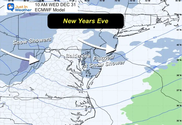
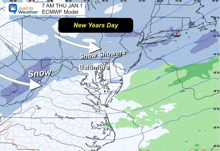
LIGHT SNOW AROUND THE NEW YEAR
With Arctic air already in place, a clipper system is forecast to cross the region, bringing a chance for light snow Wednesday evening through Thursday morning.
At this point, I am focusing on the ‘confetti’ falling from the sky and am using the word ‘light’. I would not change any plans at this time. But after the front crosses today, I will have a better idea of what may fall and accumulate.
New Year’s Eve
New Year’s Day
Jet Stream: COLD WILL HOLD
New Year’s Day

Animation
January 6
There are signals across global patterns that support an active weather pattern and potential storm(s) off the East Coast for the middle of January.

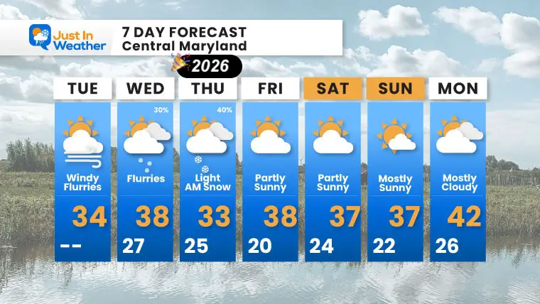
7 DAY FORECAST
- Tuesday: Windy with flurries. High 34°F.
- Wednesday (New Year’s Eve): Flurries possible (30%). High 38°F, Low 27°F.
- Thursday (New Year’s Day): Light AM snow possible (40%). High 33°F, Low 25°F.
- Friday: Partly sunny. High 38°F, Low 20°F.
- Saturday: Partly sunny. High 37°F, Low 24°F.
- Sunday: Mostly sunny. High 37°F, Low 22°F.
- Monday: Mostly cloudy. High 42°F, Low 26°F.
Subscribe for email Alerts
FAITH IN THE FLAKES STORE
NOW OPEN FOR THE SEASON
click here

Snow Report December 14 and Grade My Forecast
In case you missed it, click this image for brief summary of the final snow totals from the last event.

Snow Report December 5 to 6 and Grade My Forecast
In case you missed it, click this image for brief summary of the final snow totals from the last event.

My Winter Outlook For Above-Average Snow
Click here for the full report

La Niña Advisory
This was issued October 9, as expected: A weak and short-lived event to start winter may play a different role this winter.

In Case You Missed It
Woolly Bear Caterpillar Winter Folklore
These are NOT all the same caterpillar!

Winter Outlook From 2 Farmers’ Almanacs

STEM Assemblies/In School Fields Trips Are Back
Click to see more and ‘Book’ a visit to your school

THANK YOU:
Baltimore Sun Magazine Readers’ Choice Best Of Baltimore

Maryland Trek 12 Day 7 Completed Sat August 9
UPDATED: We raised OVER $170,000 for Just In Power Kids – AND Still Collecting More
The annual event: Hiking and biking 329 miles in 7 days between The Summit of Wisp to Ocean City.
Each day, we honor a kid and their family’s cancer journey.
Fundraising is for Just In Power Kids: Funding Free Holistic Programs. I never have and never will take a penny. It is all for our nonprofit to operate.
Click here or the image to donate:

RESTATING MY MESSAGE ABOUT DYSLEXIA
I am aware there are some spelling and grammar typos and occasional other glitches. I take responsibility for my mistakes and even the computer glitches I may miss. I have made a few public statements over the years, but if you are new here, you may have missed it: I have dyslexia and found out during my second year at Cornell University. It didn’t stop me from getting my meteorology degree and being the first to get the AMS CBM in the Baltimore/Washington region. One of my professors told me that I had made it that far without knowing and to not let it be a crutch going forward. That was Mark Wysocki, and he was absolutely correct! I do miss my mistakes in my own proofreading. The autocorrect spell check on my computer sometimes does an injustice to make it worse. I can also make mistakes in forecasting. No one is perfect at predicting the future. All of the maps and information are accurate. The ‘wordy’ stuff can get sticky. There has been no editor who can check my work while writing and to have it ready to send out in a newsworthy timeline. Barbara Werner is a member of the web team that helps me maintain this site. She has taken it upon herself to edit typos when she is available. That could be AFTER you read this. I accept this and perhaps proves what you read is really from me… It’s part of my charm. #FITF
Please share your thoughts and best weather pics/videos, or just keep in touch via social media.


