Wednesday, December 24, 2025
Happy Christmas Eve! We have been in one of the coldest Decembers on record and are being gifted with a mild Christmas holiday today and tomorrow. Then, reality comes back as the edge of a cold air mass from the North will barely get through Central Maryland. It will be a shallow layer of cold when the next weather event arrives with warmer clouds. The net result is the concern of sleet and freezing rain.
An important point worth mentioning: Ground Temperatures! The ground may still be warm, and the expected afternoon timing of the event may limit icing to elevated surfaces while most roads stay wet. But not all. There are other details to explore below.
We will have more swings as the warm-up with rain Sunday night into Monday will be followed by a new arctic air mass just before the New Year!
A lot to unpack in this report.
HEADLINES
- Windy Today
- Christmas Eve and Day Stay Mild
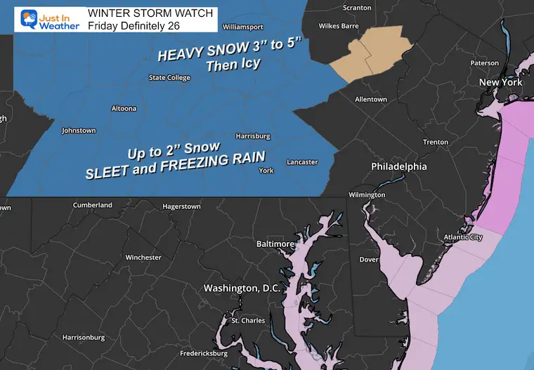
- Friday: Concern For Freezing Rain, Sleet, and Snow Traveling North
- Sunday: Evening Rain with possible thunder
- MUCH COLDER NEXT WEEK
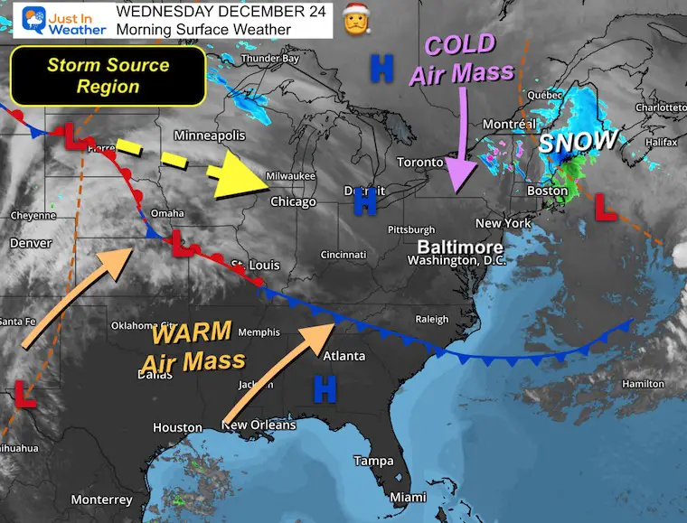
Morning Surface Weather
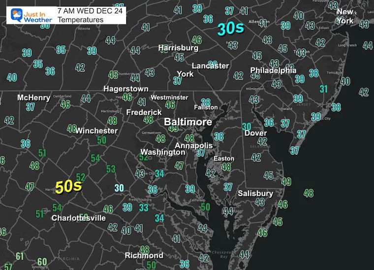
Morning Temperatures
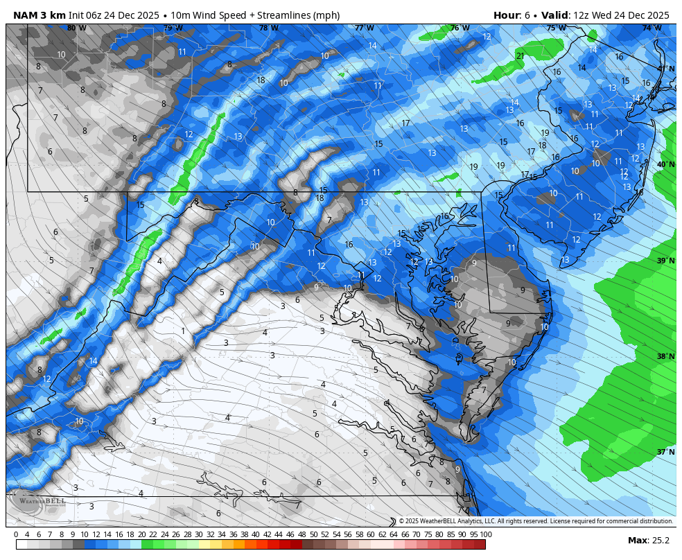
Wind Forecast: 7 AM to 7 PM
Gusts may reach 45 mph this morning, then ease this afternoon.
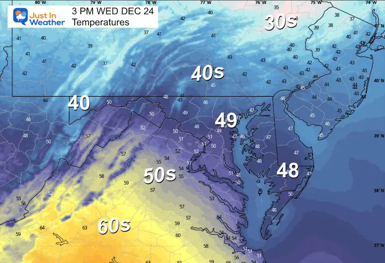
Afternoon Temperatures
Look at the spread again in our region!!
30s in northern Pennsylvania, while 60s to the South in Virginia.
MOUNTAIN CAM:
WESTERN MARYLAND
Wind is still in full force in this region. A fresh coating to a few inches of snow has blanketed the region.
This webcam is positioned at The Greene Turtle Deep Creek Lake and shows Wisp Resort, including a zoomed-in view of Squirrel Cage, The Face, the terrain park, Boulder, the mountain coaster, the tubing park and a shot of McHenry Cove at Deep Creek Lake!
CLIMATE DATA: Baltimore
Yesterday: Low 38°F; High 43°F
Precipitation: 0.02″
Season Snow Total: 2.0″
Snow Depth: 0″
Top Wind Gust: 13 mph
TODAY December 24
Sunrise at 7:24 AM
Sunset at 4:49 PM
Normal Low in Baltimore: 28ºF
Record Low: 4ºF in 1983
Normal High in Baltimore: 45ºF
Record High: 71ºF in 2015
Rainfall Deficit at BWI
- Ending 2024 = -8.00″
- Since Jan 1 = -8.16″
- We are STILL DOWN -16.16″ INCLUDING LAST YEAR
Subscribe For email Alerts
FAITH IN THE FLAKES STORE
NOW OPEN FOR THE SEASON
click here

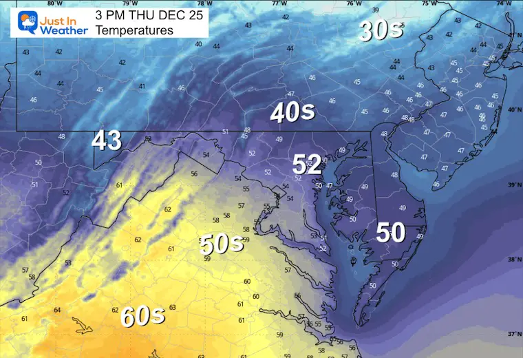
THURSDAY: Christmas Day
Mild with some rain showers. Not a concern!
Look at the spread again in our region!!
Morning Temperatures

Radar Simulation 7 AM to 7 PM
Spotty rain showers.
Afternoon Temperatures
Looking Ahead: Freezing Rain Friday?
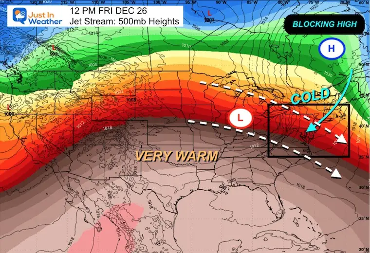
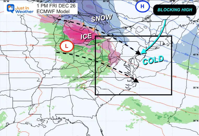
Friday Noon Jet Stream
The storm track is focused across the Northern USA, with warm air to the south and cold air pushed by a Blocking High in Eastern Canada into New England.
How far that cold air reaches is important, and it looks like it just barely makes it through Central Maryland.
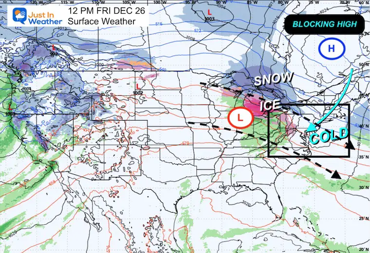
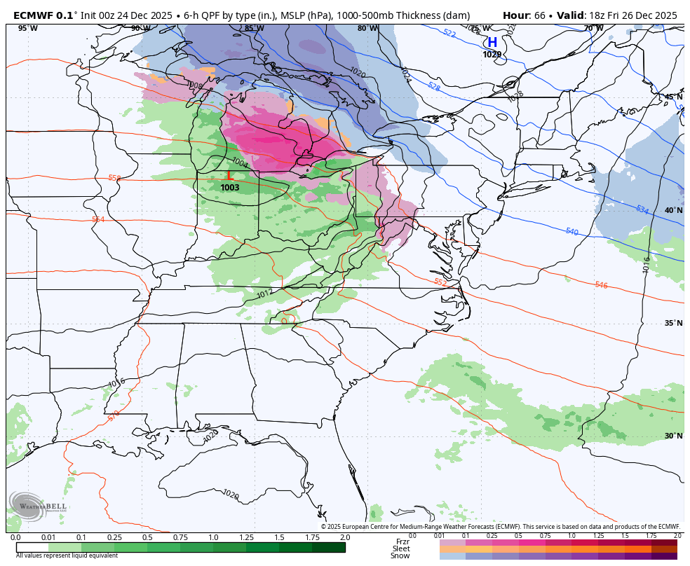
Friday Surface Weather
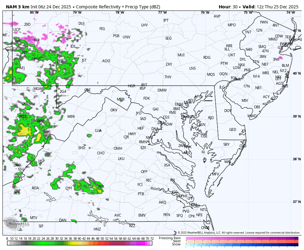
The weather system we are watching will track along that boundary between the warm and cold air. A large region of snow and ice across the Great Lakes will expand to the Mid-Atlantic and New England.
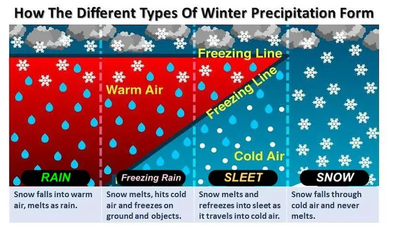
Winter Precipitation
The complication with a layer of warm air into the clouds while cold air hugs near the ground.
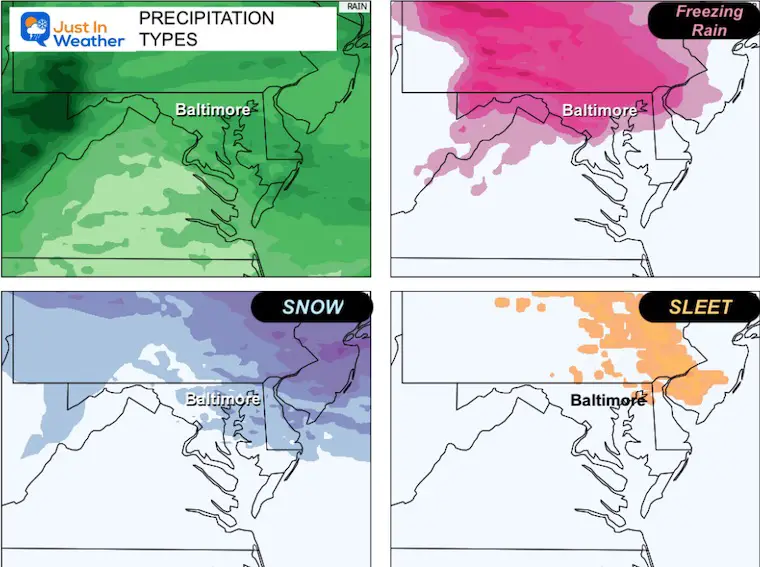
The DEPTH of cold air will determine if rain can freeze to ice pellets (sleet) or remain rain and then freeze on contact with the ground (freezing rain). Both are icy! Sleet is tiny balls of ice, freezing rain is just a layer of glaze that is smooth and more slippery.
Closer Look
As Low Pressure and precipitation move in, a layer of cold air will hold close to the ground. The net result will be a large region where rain will fall and freeze on the way down to the ground. That is where the sleet and freezing rain will fall.
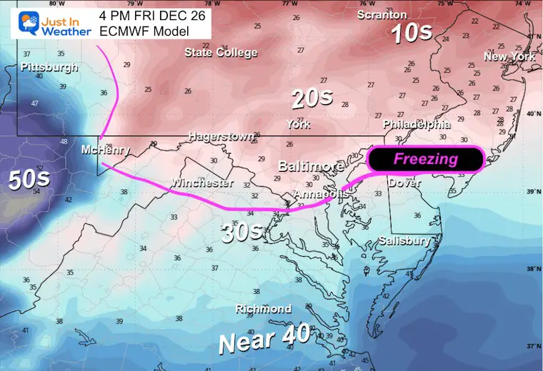
NOTE: Ground temps in our region may remain warmer in Central Maryland, closer to the Pennsylvania line, and north could be cold enough for ice to form and affect travel.
Even if roads stay wet near you, elevated steps, bridges, along with trees and powerlines, are susceptible to ice building up.
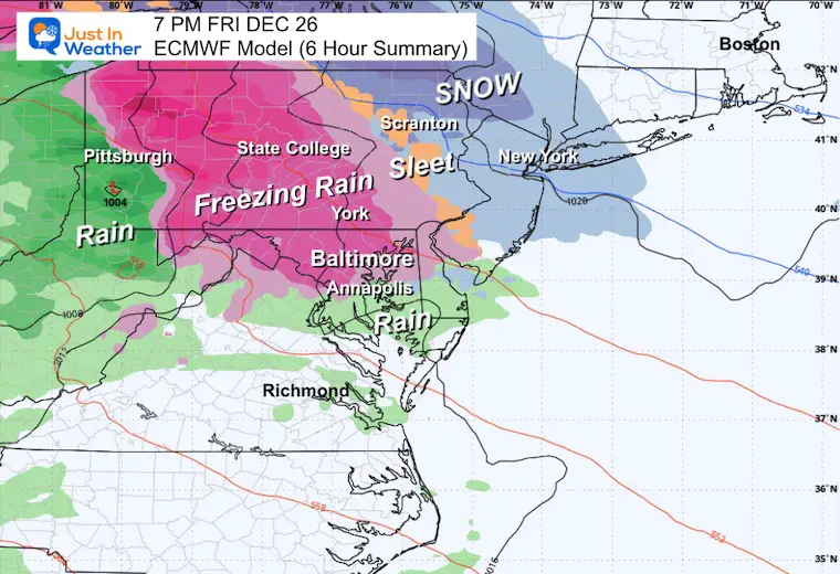
Storm Animation Friday Afternoon to Saturday Evening
Snapshot Friday Evening
This is a 6-hour summary between 1 PM and 6 PM
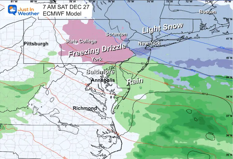
- While some ice may start near Washington and Annapolis, it is likely to turn to rain.
- Freezing rain and building ice are more likely near and especially NORTH/WEST of Baltimore.
- Further north, sleet and snow are expected from the Poconos of northeast PA to New England.
Snapshot Saturday Morning
Lingering freezing drizzle in Southern PA with lingering light snow across metro New York and New England.
Precipitation Breakdown
FRIDAY TEMPERATURES
POTENTIAL FREEZING RAIN
This could be a more serious problem in the Maryland mountains, suburbs north of Baltimore, and across Pennsylvania, where 0.25” to 0.50” ice is possible.
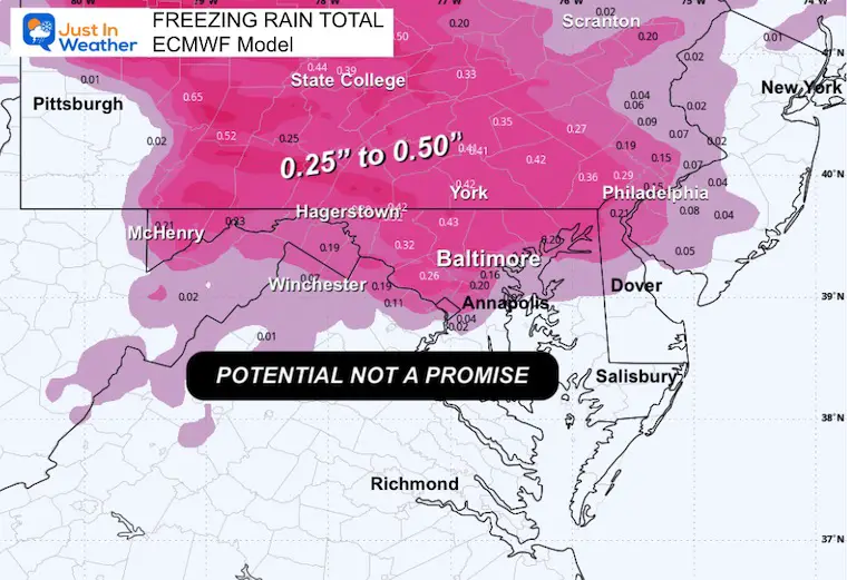
WINTER STORM WATCH: Pennsylvania for now
NEXT UP
Sunday to Tuesday
After the ice event, a warm-up over the weekend will surge ahead of the next cold front.
Rain develops later Sunday and may be heavy overnight to Monday morning. This will be along a cold front with arctic air flowing in behind.
Thunder is possible with the downpours.

Jet Stream Sunday to Tuesday
Arctic air will be in place before New Year’s Eve!

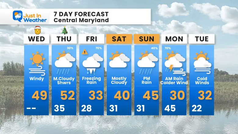
7 Day Forecast
- Wednesday (Christmas Eve): Windy – High 49°F.
- Thursday (Christmas Day): Mostly cloudy with showers possible (30%). High 52°F, Low 35°F.
- Friday: Freezing rain likely (70%). High 33°F, Low 28°F.
- Saturday: Mostly cloudy. High 40°F, Low 31°F.
- Sunday: PM rain (40%). High 45°F, Low 31°F.
- Monday: AM rain and maybe thunder. High of 45°F in the morning, then falling temps with colder winds.
- Tuesday: Cold winds. High 32°F, Low 22°F.
Subscribe for eMail Alerts
Snow Report December 14 and Grade My Forecast
In case you missed it, click this image for brief summary of the final snow totals from the last event.

Snow Report December 5 to 6 and Grade My Forecast
In case you missed it, click this image for brief summary of the final snow totals from the last event.

My Winter Outlook For Above-Average Snow
Click here for the full report

La Niña Advisory
This was issued October 9, as expected: A weak and short-lived event to start winter may play a different role this winter.

In Case You Missed It
Woolly Bear Caterpillar Winter Folklore
These are NOT all the same caterpillar!

Winter Outlook From 2 Farmers’ Almanacs

STEM Assemblies/In School Fields Trips Are Back
Click to see more and ‘Book’ a visit to your school

THANK YOU:
Baltimore Sun Magazine Readers’ Choice Best Of Baltimore

Maryland Trek 12 Day 7 Completed Sat August 9
UPDATED: We raised OVER $170,000 for Just In Power Kids – AND Still Collecting More
The annual event: Hiking and biking 329 miles in 7 days between The Summit of Wisp to Ocean City.
Each day, we honor a kid and their family’s cancer journey.
Fundraising is for Just In Power Kids: Funding Free Holistic Programs. I never have and never will take a penny. It is all for our nonprofit to operate.
Click here or the image to donate:

RESTATING MY MESSAGE ABOUT DYSLEXIA
I am aware there are some spelling and grammar typos and occasional other glitches. I take responsibility for my mistakes and even the computer glitches I may miss. I have made a few public statements over the years, but if you are new here, you may have missed it: I have dyslexia and found out during my second year at Cornell University. It didn’t stop me from getting my meteorology degree and being the first to get the AMS CBM in the Baltimore/Washington region. One of my professors told me that I had made it that far without knowing and to not let it be a crutch going forward. That was Mark Wysocki, and he was absolutely correct! I do miss my mistakes in my own proofreading. The autocorrect spell check on my computer sometimes does an injustice to make it worse. I can also make mistakes in forecasting. No one is perfect at predicting the future. All of the maps and information are accurate. The ‘wordy’ stuff can get sticky. There has been no editor who can check my work while writing and to have it ready to send out in a newsworthy timeline. Barbara Werner is a member of the web team that helps me maintain this site. She has taken it upon herself to edit typos when she is available. That could be AFTER you read this. I accept this and perhaps proves what you read is really from me… It’s part of my charm. #FITF
Please share your thoughts and best weather pics/videos, or just keep in touch via social media.


