Saturday, December 20, 2025
The FIERCE FRIDAY lived up to expectations. The Peak Wind Gust at BWI was 56 mph, while Camp David in the mountains of Northern Frederick County popped at 62 mph.
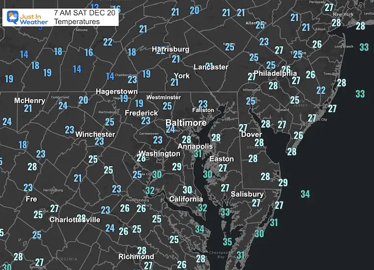
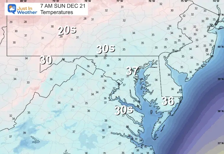
The official high temperature at BWI was 60F at 5 AM, then that wind ushered in this new cold air mass. We start this morning in the teens and 20s.
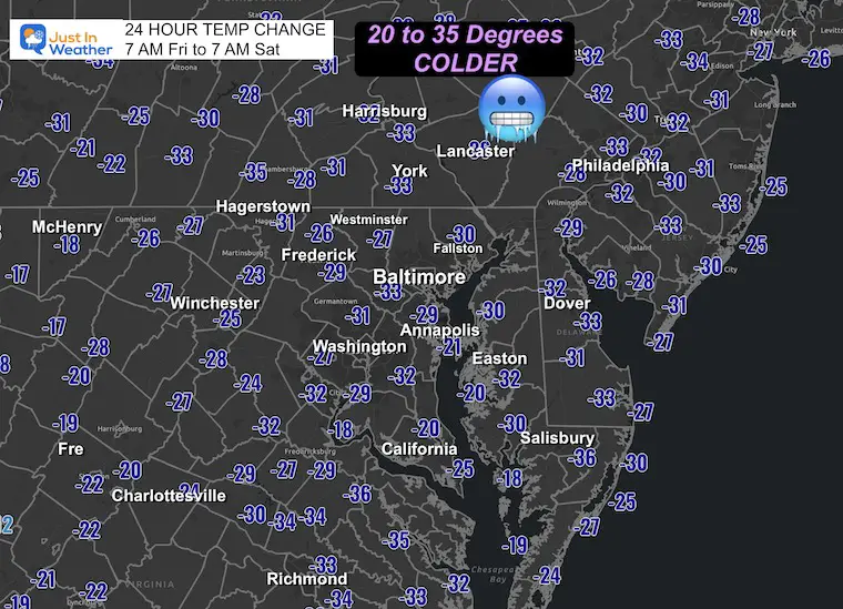
Most of the region is between 20 and 35 degrees COLDER than yesterday morning!
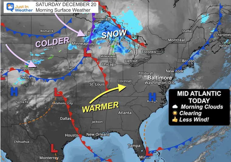
The good news is that we are turning the corner. Even if you wake up with clouds, the wind has already relaxed, and sunshine should get us a moderate and quiet weekend.
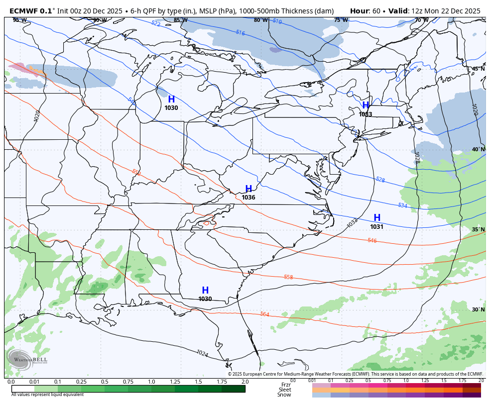
Next week, a surge of record warmth in the middle of the nation will try, but not fully get here. On the edge, a band of wintry weather will develop on Tuesday. We might see a brief wintry mix in the morning, then turn to rain. But if you are traveling to New York or New England, keep an eye out for some impact snow.
Christmas itself looks quiet.
Then we will look ahead to the pattern expectations for winter reloading into early January.
HEADLINES
- Some Morning Clouds and Cold
- Afternoon Sun
- Less Wind
- A little ‘something-something’ before Christmas.
MORNING TEMPERATURES
24 Hour Change
7 AM Numbers
Morning Surface Weather
High Pressure will track off the coast, shifting our light wind from the south, allowing a push of mild air to return.
There is one more push of cold air that will reach us on Monday.
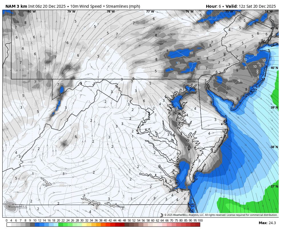
Wind Forecast 7 AM Fri to 7 AM Sat
Look closely, and you might see the High Pressure pass across Southern Maryland and shift the winds this afternoon and evening.
Afternoon Temperatures

MOUNTAIN CAM: WESTERN MARYLAND SNOW
Wind is still in full force in this region. A fresh coating to a few inches of snow has blanketed the region.
This webcam is positioned at The Greene Turtle Deep Creek Lake and shows Wisp Resort, including a zoomed-in view of Squirrel Cage, The Face, the terrain park, Boulder, the mountain coaster, the tubing park and a shot of McHenry Cove at Deep Creek Lake!
CLIMATE DATA: Baltimore
Yesterday: Low 33°F; High 60°F
Precipitation: 0.22″
Season Snow Total: 2.0″
Snow Depth: 0″
Top Wind Gust: 56 mph
TODAY December 20
Sunrise at 7:22 AM
Sunset at 4:47 PM
Normal Low in Baltimore: 29ºF
Record Low: 6ºF in 1942
Normal High in Baltimore: 46ºF
Record High: 67ºF in 1877
Rainfall Deficit at BWI
- Ending 2024 = -8.00″
- Since Jan 1 = -7.71″
- We are STILL DOWN -15.71″ INCLUDING LAST YEAR
FAITH IN THE FLAKES STORE
NOW OPEN FOR THE SEASON
click here

SUNDAY
Morning Temperatures
Afternoon Temperatures

Looking Ahead: Monday To Christmas
As warm air builds in the middle of the nation, we will be on the edge of that, where a battle zone will develop unsettled weather.
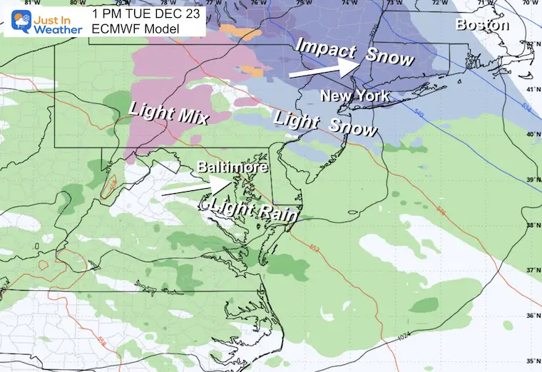
A band of light rain and snow will develop along the transition to the warmer air. We will be in the zone from the Mid-Atlantic to New England.
There will be snow across the Poconos, New York, and New England. However, the impact around the Mid-Atlantic is less certain.
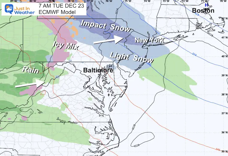
Here is the European Model showing a hint of brief, light snow in Southern Pennsylvania, then turning to a light rain on Tuesday.
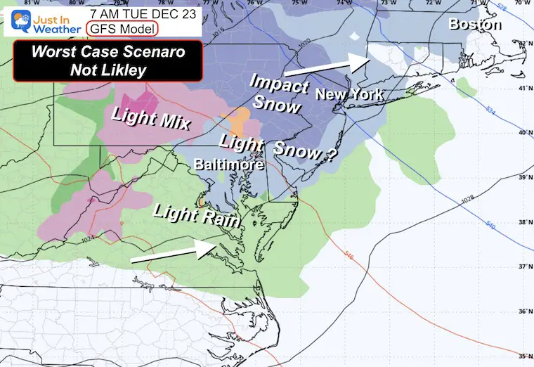
Compare that to the more aggressive and less likely display from GFS placing the light snow into Maryland Tuesday morning.
Christmas Holiday Weather
Tuesday Morning: ECMWF
Light rain across Maryland with a mix into Eastern PA and snow for New York and New England.
Tuesday Morning: GFS
Tuesday Afternoon: ECMWF
Light rain locally, but there will be snow around New York City to New England.
Looking Ahead: Jet Stream To January 3
United States View
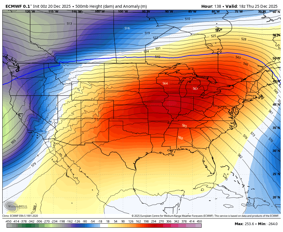
After one of the coldest starts to December, the pattern will relax for the Holiday week. The middle of the US will have record warmth, but we will just be a little above average.
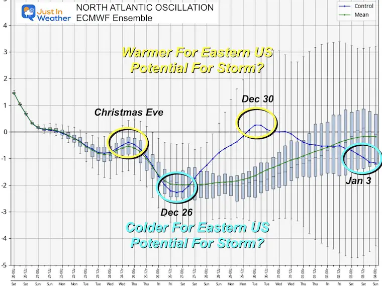
The next push of colder air will arrive the weekend after Christmas.
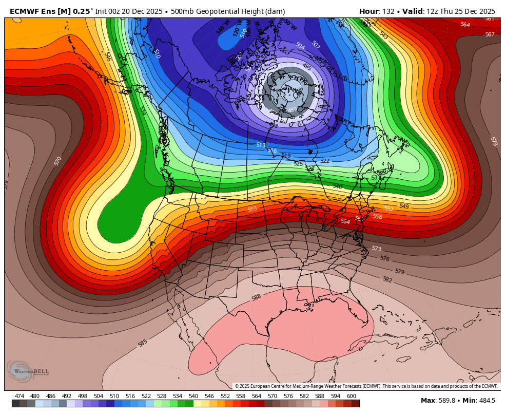
North America View
This wide view of North America shows a strengthening Polar Vortex. I see this as Winter Reloading. While the pattern may appear bland, it is normal for an extreme setup like we just had to relax, and then possibly return.
Northern Hemisphere
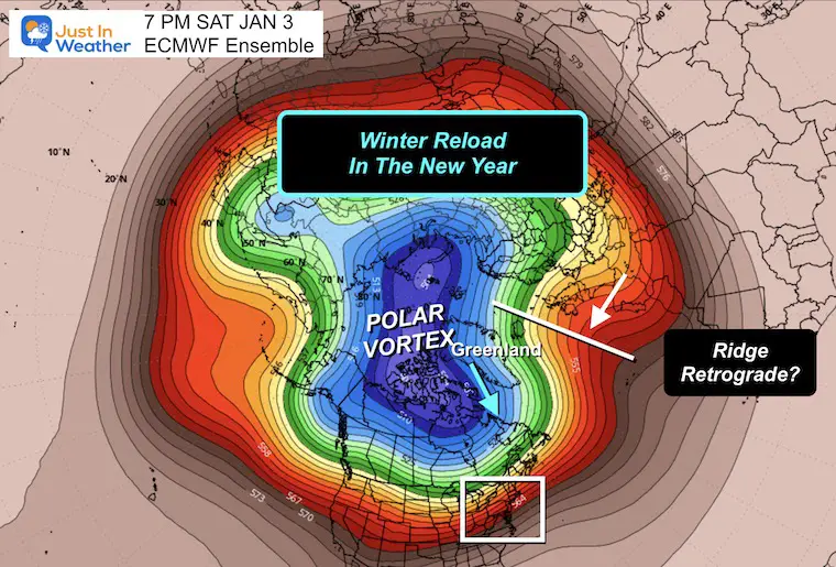
This snapshot on January 3 shows the stretching out of the Polar Vortex again. Looking out this far is more for trend rather than specifics. I am looking at the cold air in Europe/Scandinavia to retrograde. That would be building Westward towards Greenland.
If you want snow, that Greenland Ridge is what we would need to shift the North Atlantic Oscillation NEGATIVE and send colder unsettled air into the Eastern US. This looks like the plan developing in the first and second week of the new year.
North Atlantic Oscillation
This is ONE of the global patterns we look at to influence our weather.
After Christmas, we will get a shot of colder air, then warming again by New Year’s… and settling back to a favorable colder trend in early January.
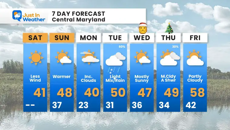
7 Day Forecast
- Today: More Sun and Less Wind!
- Sunday: A little Warmer
- Monday: Another push of colder air.
- Christmas Eve: Simply SUGGESTION: A Chance For light snow or mix to the north, but I am keeping an eye out for any brief start in our region before turning to just rain.
- Christmas Day looks mild with a small chance of a shower. There will be one warm day next Friday, then a colder air mass next weekend.
Subscribe for eMail Alerts
Snow Report December 14 and Grade My Forecast
In case you missed it, click this image for brief summary of the final snow totals from the last event.

Snow Report December 5 to 6 and Grade My Forecast
In case you missed it, click this image for brief summary of the final snow totals from the last event.

My Winter Outlook For Above-Average Snow
Click here for the full report

La Niña Advisory
This was issued October 9, as expected: A weak and short-lived event to start winter may play a different role this winter.

In Case You Missed It
Woolly Bear Caterpillar Winter Folklore
These are NOT all the same caterpillar!

Winter Outlook From 2 Farmers’ Almanacs

STEM Assemblies/In School Fields Trips Are Back
Click to see more and ‘Book’ a visit to your school

THANK YOU:
Baltimore Sun Magazine Readers’ Choice Best Of Baltimore

Maryland Trek 12 Day 7 Completed Sat August 9
UPDATED: We raised OVER $170,000 for Just In Power Kids – AND Still Collecting More
The annual event: Hiking and biking 329 miles in 7 days between The Summit of Wisp to Ocean City.
Each day, we honor a kid and their family’s cancer journey.
Fundraising is for Just In Power Kids: Funding Free Holistic Programs. I never have and never will take a penny. It is all for our nonprofit to operate.
Click here or the image to donate:

RESTATING MY MESSAGE ABOUT DYSLEXIA
I am aware there are some spelling and grammar typos and occasional other glitches. I take responsibility for my mistakes and even the computer glitches I may miss. I have made a few public statements over the years, but if you are new here, you may have missed it: I have dyslexia and found out during my second year at Cornell University. It didn’t stop me from getting my meteorology degree and being the first to get the AMS CBM in the Baltimore/Washington region. One of my professors told me that I had made it that far without knowing and to not let it be a crutch going forward. That was Mark Wysocki, and he was absolutely correct! I do miss my mistakes in my own proofreading. The autocorrect spell check on my computer sometimes does an injustice to make it worse. I can also make mistakes in forecasting. No one is perfect at predicting the future. All of the maps and information are accurate. The ‘wordy’ stuff can get sticky. There has been no editor who can check my work while writing and to have it ready to send out in a newsworthy timeline. Barbara Werner is a member of the web team that helps me maintain this site. She has taken it upon herself to edit typos when she is available. That could be AFTER you read this. I accept this and perhaps proves what you read is really from me… It’s part of my charm. #FITF
Please share your thoughts and best weather pics/videos, or just keep in touch via social media.


