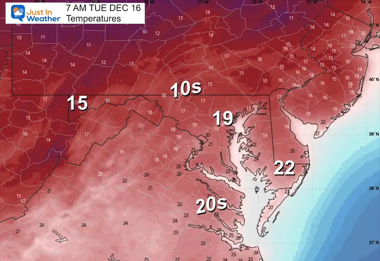
Monday Morning December 15, 2025
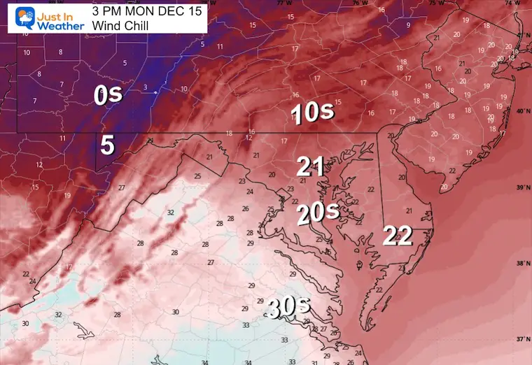
Today starts off cold, with areas of black ice forming due to blowing snow and refreezing overnight. While there is a breeze and wind chill to contend with, the winds will ease, and eventually we will warm up during the week. This will be ahead of the next storm to bring rain Thursday night and Friday morning.
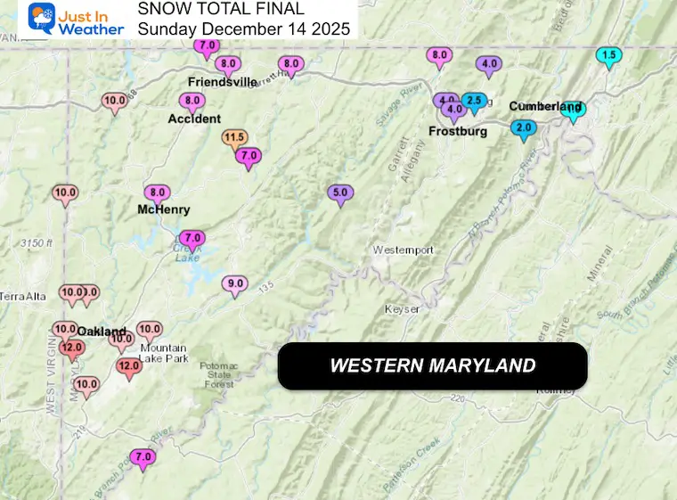
Note: I posted the final snow report last night, but there was an error in my map, which didn’t account for the snow in Southern Maryland and Delmarva. That has been corrected below and in my report.
HEADLINES
- Very cold morning with wind chills in the single digits and lower teens
- Early icy spots will thaw even with temps staying below freezing
- Warmer Mid Week
- Late Week Rain/T’storm
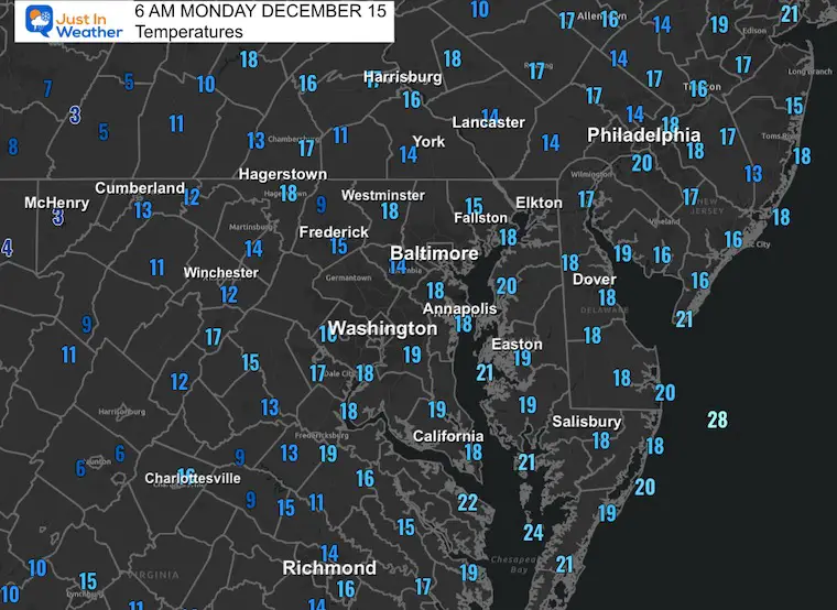
Morning Temperatures
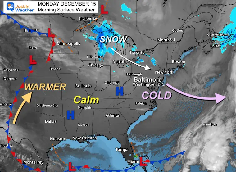
Morning Surface Weather
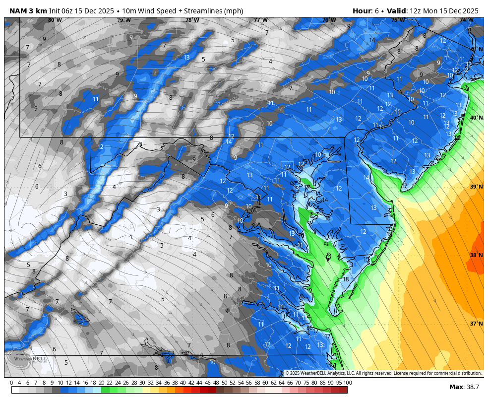
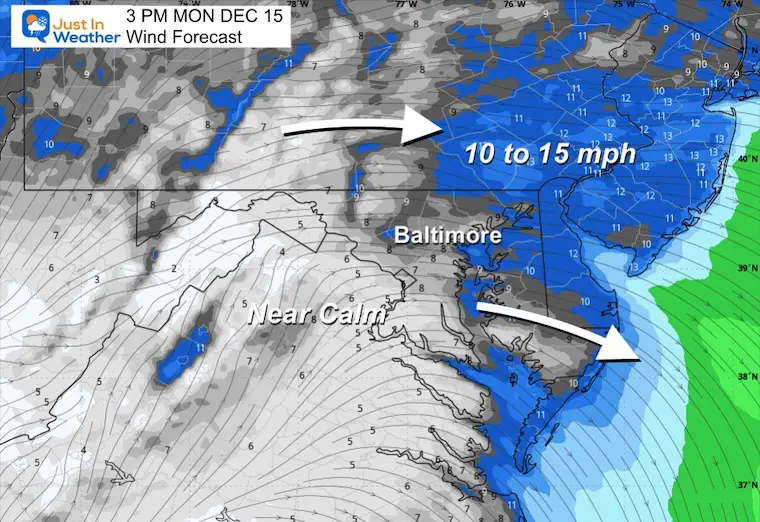
Wind Forecast 7 AM to 7 PM
Afternoon Snapshot
Settling to a light breeze.
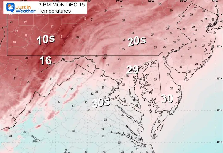
Afternoon Temperatures
Afternoon Wind Chill
SNOW REPORTS

WESTERN MARYLAND SNOW
Storm Total: Mostly 10 to 12 inches of new snow
This webcam is positioned at The Greene Turtle Deep Creek Lake and shows Wisp Resort, including a zoomed-in view of Squirrel Cage, The Face, the terrain park, Boulder, the mountain coaster, the tubing park and a shot of McHenry Cove at Deep Creek Lake!
CLIMATE DATA: Baltimore
Yesterday: Low 16F; High 36F
Precipitation: 0.27” – None reached the airport by midnight
Snow = 1.0” (surrounding the airport, many areas reached 2”+)
Season Snow Total: 2.0”
Top Wind Gust: 15 mph
TODAY December 15
Sunrise at 7:19 AM
Sunset at 4:45 PM
Normal Low in Baltimore: 30ºF
Record 9ºF in 1960; 1962
Normal High in Baltimore: 48ºF
Record 70ºF in 1929; 1971
Rainfall Deficit at BWI
- Ending 2024 = -8.00”
- Since Jan 1 = 7.37”
- We are STILL DOWN -15.37” INCLUDING LAST YEAR
Subscribe for eMail Alerts
FAITH IN THE FLAKES STORE
NOW OPEN FOR THE SEASON
click here

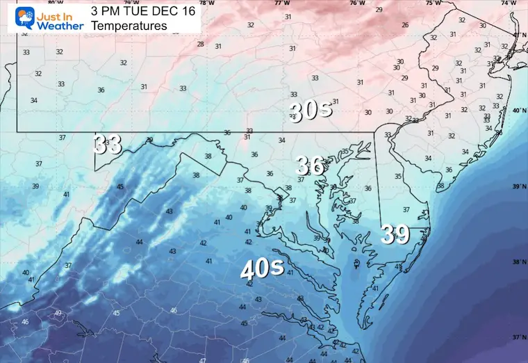
TUESDAY TEMPERATURES
Cold but modifying with less wind.
Morning Temperatures
Afternoon Temperatures
Looking Later In The Week
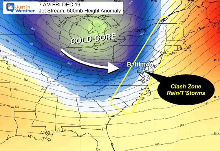
Jet Stream Forecast Tuesday to Friday Morning
Snapshot Friday Morning
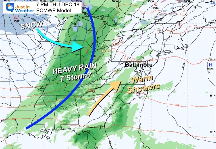
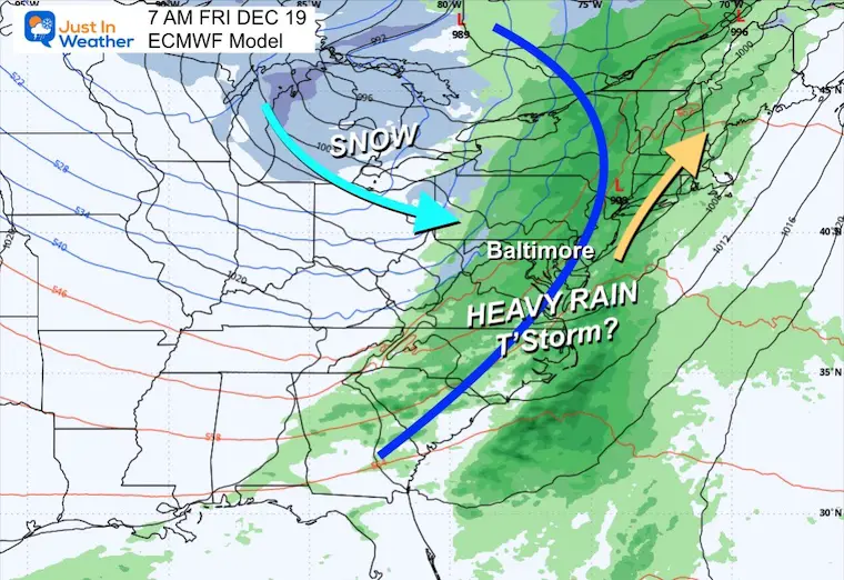
A warm-up ahead of the next storm. The clash of the next cold air mass will develop a large region of rain and thunderstorms.
Storm Forecast
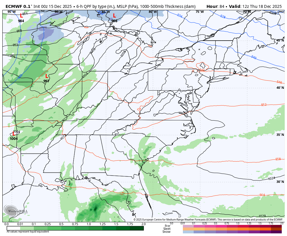
Thursday Morning to Friday Night
Thursday Night Snapshot
A warmer day and evening will also bring in the first rain showers.
Friday Morning Snapshot
A cold front will spawn heavy rain and perhaps some thunder.
Snow will return across the Great Lakes and high mountains of Western Maryland and West Virginia.
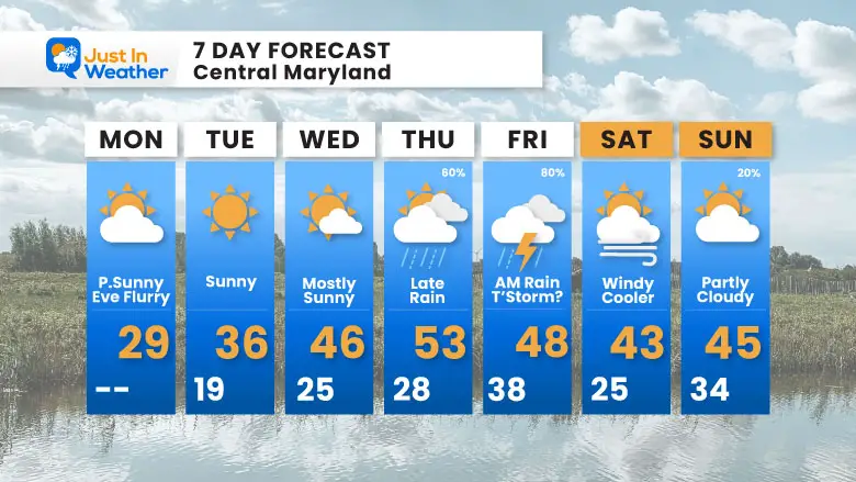
7 Day Forecast
- Today: Still cold but less windy
- Warming Up
- Wednesday = 40s
- Thursday = 50s with rain arriving late
- Friday: Rain, Wind, and maybe a T’Storm
Subscribe for eMail Alerts
Snow Report December 5 to 6 and Grade My Forecast
In case you missed it. The brief summary of the final snow totals from the last event.

My Winter Outlook For Above-Average Snow
Click here for the full report

La Niña Advisory
This was issued October 9, as expected: A weak and short-lived event to start winter may play a different role this winter.

In Case You Missed It
Woolly Bear Caterpillar Winter Folklore
These are NOT all the same caterpillar!

Winter Outlook From 2 Farmers’ Almanacs

STEM Assemblies/In School Fields Trips Are Back
Click to see more and ‘Book’ a visit to your school

THANK YOU:
Baltimore Sun Magazine Readers’ Choice Best Of Baltimore

Maryland Trek 12 Day 7 Completed Sat August 9
UPDATED: We raised OVER $170,000 for Just In Power Kids – AND Still Collecting More
The annual event: Hiking and biking 329 miles in 7 days between The Summit of Wisp to Ocean City.
Each day, we honor a kid and their family’s cancer journey.
Fundraising is for Just In Power Kids: Funding Free Holistic Programs. I never have and never will take a penny. It is all for our nonprofit to operate.
Click here or the image to donate:

RESTATING MY MESSAGE ABOUT DYSLEXIA
I am aware there are some spelling and grammar typos and occasional other glitches. I take responsibility for my mistakes and even the computer glitches I may miss. I have made a few public statements over the years, but if you are new here, you may have missed it: I have dyslexia and found out during my second year at Cornell University. It didn’t stop me from getting my meteorology degree and being the first to get the AMS CBM in the Baltimore/Washington region. One of my professors told me that I had made it that far without knowing and to not let it be a crutch going forward. That was Mark Wysocki, and he was absolutely correct! I do miss my mistakes in my own proofreading. The autocorrect spell check on my computer sometimes does an injustice to make it worse. I can also make mistakes in forecasting. No one is perfect at predicting the future. All of the maps and information are accurate. The ‘wordy’ stuff can get sticky. There has been no editor who can check my work while writing and to have it ready to send out in a newsworthy timeline. Barbara Werner is a member of the web team that helps me maintain this site. She has taken it upon herself to edit typos when she is available. That could be AFTER you read this. I accept this and perhaps proves what you read is really from me… It’s part of my charm. #FITF
Please share your thoughts and best weather pics/videos, or just keep in touch via social media.


