


January 6 Weather Some Fog And Clouds Followed By The Warm Up With Rain By The Weekend
Tuesday, January 6, 2026 The storm track has shifted to the north. We are still on the edge, which is why we have areas of fog, and most of the…
Sunday December 14, 2025
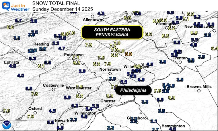
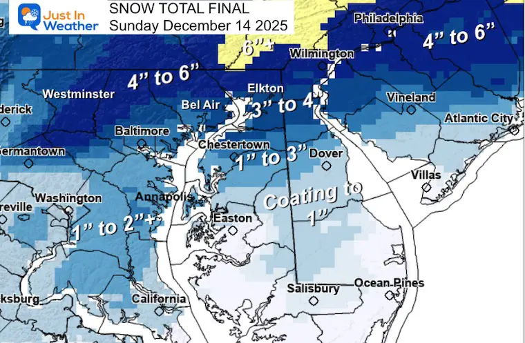
Our second true snow maker of the season left a big mark across Central Maryland to Southeast Pennsylvania as expected. I advertised it as an overachiever near Baltimore to metro Philadelphia, and that lived up to expectations. The timing, mostly overnight Saturday into early Sunday morning, was also on point. Even the potential for thundersnow was included in my last report, and it verified between 4 and 5 AM at BWI. This woke a lot of people up and was captured on video.
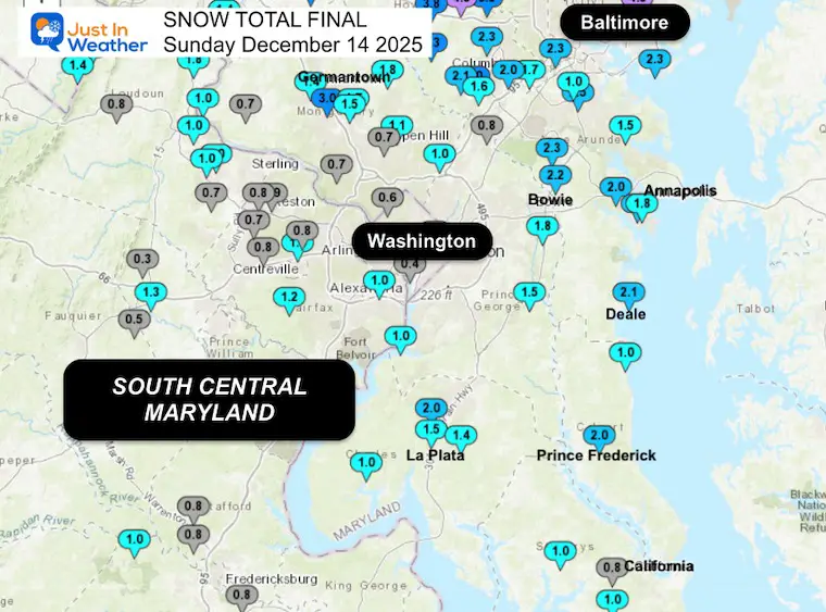
I did not account for the warm ground around Metro Washington DC to parts of lower Delmarva.
A lot of wasted flakes were melted on the warm ground.
The most frustrating was the final total at BWI reporting 1 inch. Meanwhile, there were plenty of 2”+ reports surrounding the airport. Including observations from National Weather Service employees who were nearby and on higher ground. The Urban Heat Island definitely played a role.
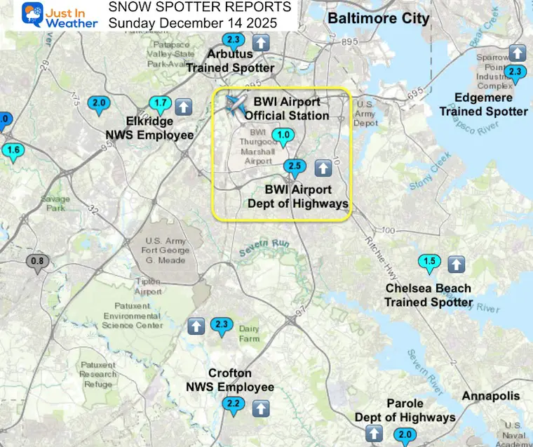
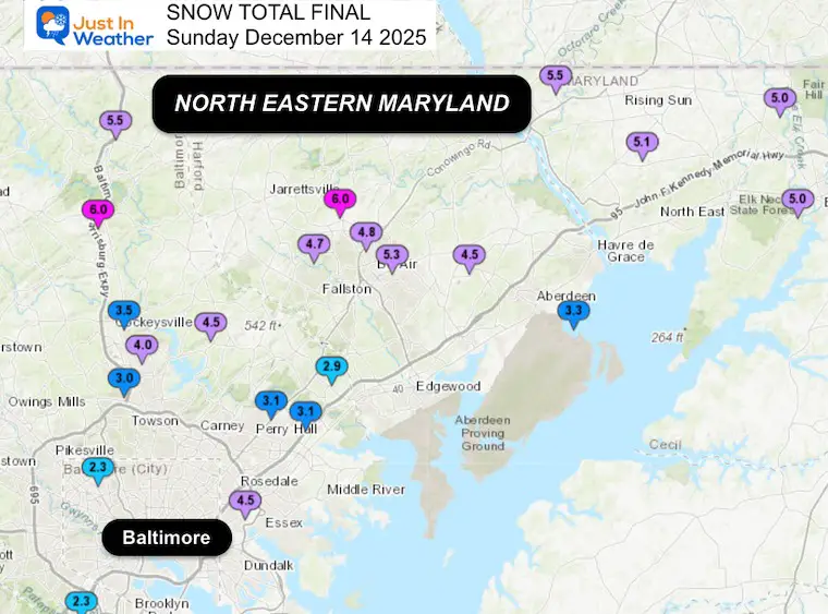
My snow totals were good north of Baltimore, but farther south, I busted.
There were pockets of 1 to 2+ inches of snow south of Baltimore
The dividing line was through Southern Baltimore and including BWI airport. So the official total was lower than my forecast, while parts of Baltimore City received 2 to 4.5 inches of snow.
Washington DC fell under 1 inch, but Annapolis reached 1” to 2” as well as some of Southern Maryland.
Delmarva also struggled to hold much snow from Easton to Salisbury.


Confirmation of ThunderSnow
Did you hear it?
🔊 Sound On
⚡️ ❄️ A few bright flashes and loud Booms woke people up early Sunday around Baltimore.
This was from Essex at 4:25 AM
🎥 Thanks To Ken Cold for sharing this. #thundersnow#Snow#FITF pic.twitter.com/yyz4jICGzo— Justin Berk (@JustinWeather) December 14, 2025
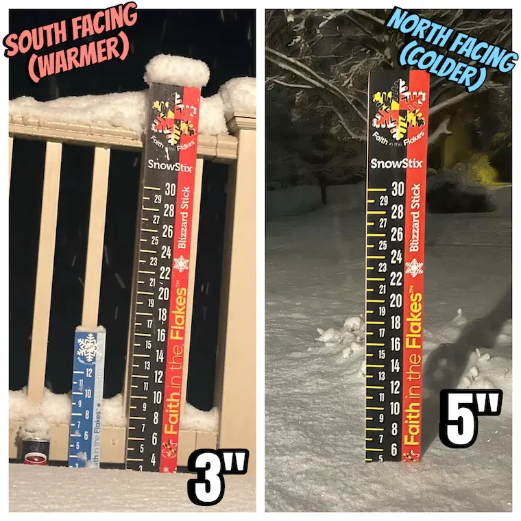
My house had 3” to 5” showing the influence of the warmer southern side melting quite a bit.
It is important to take at least 3 measurements and get the average.
Reflectivity mosaic loop of last night’s snowstorm, showing the development of an initially near-stationary snow band over N MD/SE PA which slowly moved east later into the morning: pic.twitter.com/qK1hZVdjrX
— Tomer Burg (@burgwx) December 14, 2025
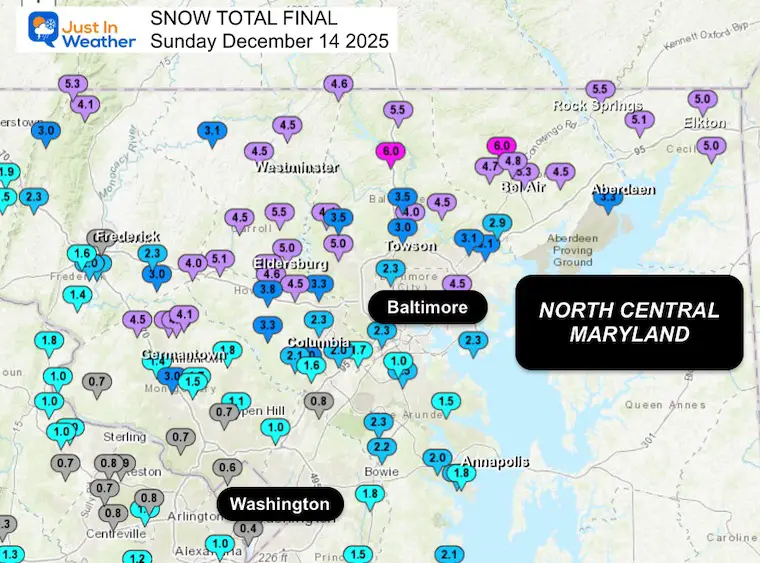
The highest snow totals were northwest of Philly, but originally though to be near and southeast.
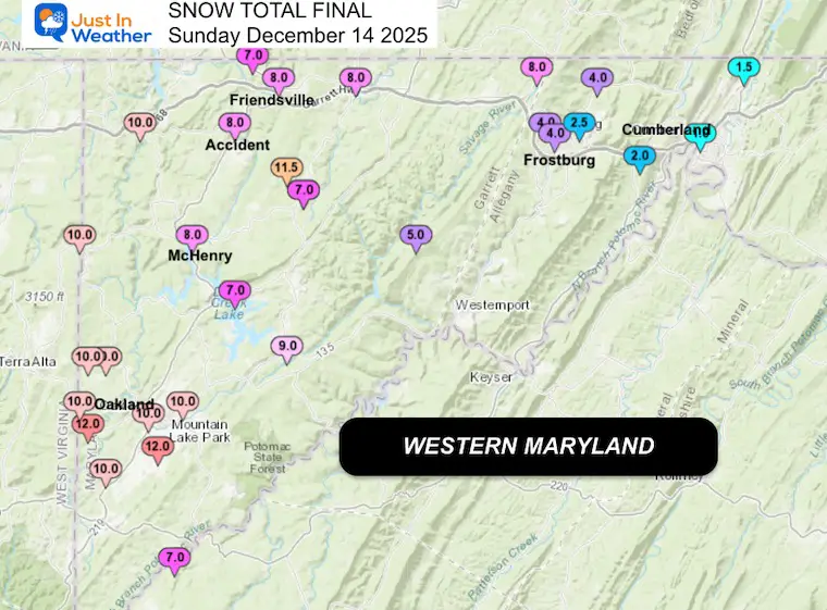
The high mountains received 10 to 12 inches in many areas.
Even though Washington DC had less than 1 inch, Southern Maryland did get 1 to 2 inches.
North of Easton my call was good.
Near and South of Easton the change to snow was later and the ground was still too warm for the snow to lay and stay.
A lot of snow was wasted to melting.
Snow Totals From The National Weather Service Baltimore Washington Office.
…District of Columbia…
National Arboretum 0.9 800 AM 12/14 Co-Op Observer
…Allegany County…
…Anne Arundel County…
…Baltimore County…
…Baltimore City…
…Calvert County…
…Carroll County…
…Cecil County…
…Charles County…
…Frederick County…
…Garrett County…
…Harford County…
…Howard County…
…Montgomery County…
…Prince Georges County…
…St. Marys County…
…Washington County…
Subscribe for eMail Alerts
Sign up and be the first to know!

…Albemarle County…
…Arlington County…
…City of Alexandria…
…Culpeper County…
…Fairfax County…
…Fauquier County…
…Frederick County…
…Highland County…
…Loudoun County…
…Page County…
…Prince William County…
…Rockingham County…
…Spotsylvania County…
…Stafford County…
…Warren County…
…Berkeley County…
…Grant County…
…Jefferson County…
…Pendleton County…
************24 HOUR SNOWFALL (AT LEAST 0.1 INCH)************
LOCATION 24 HOUR TIME/DATE COMMENTS
SNOWFALL MEASURED
(inches)
…District of Columbia…
Washington 3 NE 1.0 700 AM 12/14 CoCoRaHS
Washington 4 N 1.0 700 AM 12/14 CoCoRaHS
National Arboretum 0.9 800 AM 12/14 Co-Op Observer
…Allegany County…
Frostburg 4.0 700 AM 12/14 Co-Op Observer
Cresaptown-Bel Air 1 1.0 700 AM 12/14 CoCoRaHS
Cumberland 0.5 700 AM 12/14 Co-Op Observer
…Anne Arundel County…
Birdsville WSW 2.4 700 AM 12/14 CoCoRaHS
Pasadena 1 SE 2.0 700 AM 12/14 CoCoRaHS
Severn 2 SSW 2.0 1219 PM 12/14 CoCoRaHS
Odenton 1 N 2.0 900 AM 12/14 CoCoRaHS
Annapolis 1 SE 1.8 650 AM 12/14 CoCoRaHS
Severn 1 SSE 1.7 830 AM 12/14 CoCoRaHS
Severn 2 W 1.5 700 AM 12/14 CoCoRaHS
Deale 1 SE 1.0 700 AM 12/14 CoCoRaHS
…Baltimore County…
Timonium NE 3.5 700 AM 12/14 CoCoRaHS
Towson 1 SW 3.1 830 AM 12/14 CoCoRaHS
Kingsville 1 E 2.9 700 AM 12/14 CoCoRaHS
Long Green 1 SW 2.8 700 AM 12/14 CoCoRaHS
Perry Hall ENE 2.7 600 AM 12/14 CoCoRaHS
White Marsh 2 ESE 2.0 700 AM 12/14 CoCoRaHS
…Baltimore City…
Mount Washington 1 N 3.0 700 AM 12/14 CoCoRaHS
…Calvert County…
Dunkirk 3.2NNE 2.0 800 AM 12/14 CoCoRaHS
North Beach 2 WNW 1.5 930 AM 12/14 CoCoRaHS
Huntingtown 3 NNW 1.5 800 AM 12/14 CoCoRaHS
Benedict 5 ENE 1.4 830 AM 12/14 CoCoRaHS
Chesapeake Beach 1 W 1.2 800 AM 12/14 CoCoRaHS
Prince Frederick 1 W 1.1 800 AM 12/14 CoCoRaHS
…Carroll County…
Gamber 1 W 5.5 800 AM 12/14 CoCoRaHS
Eldersburg 1 E 5.0 700 AM 12/14 CoCoRaHS
Mount Airy SE 4.5 700 AM 12/14 CoCoRaHS
Taneytown 4 NE 3.5 830 AM 12/14 CoCoRaHS
Marston 2 N 3.0 700 AM 12/14 CoCoRaHS
…Cecil County…
Elkton 5 NW 4.0 900 AM 12/14 CoCoRaHS
Chesapeake City 7 WS 3.0 800 AM 12/14 CoCoRaHS
…Charles County…
Waldorf 3 S 1.5 800 AM 12/14 CoCoRaHS
La Plata 6 SE 1.5 700 AM 12/14 CoCoRaHS
Bryantown 2 NE 1.4 700 AM 12/14 CoCoRaHS
…Frederick County…
Middletown 2.2 700 AM 12/14 CoCoRaHS
…Garrett County…
McHenry 5 SSE 8.0 1200 PM 12/14 CoCoRaHS
…Harford County…
Norrisville 1 WSW 7.1 630 AM 12/14 CoCoRaHS
Kingsville 3 NNE 4.3 700 AM 12/14 CoCoRaHS
…Howard County…
Mount Airy 5 SE 6.0 700 AM 12/14 CoCoRaHS
Sykesville 3 SE 5.0 800 AM 12/14 CoCoRaHS
Sykesville 2 SSE 4.6 700 AM 12/14 CoCoRaHS
Woodbine 5 SSW 4.5 800 AM 12/14 CoCoRaHS
Marriottsville 3 S 3.9 700 AM 12/14 CoCoRaHS
Elkridge 2 W 2.2 700 AM 12/14 CoCoRaHS
Columbia 2 N 2.0 700 AM 12/14 CoCoRaHS
Columbia 2 NNW 1.9 744 AM 12/14 CoCoRaHS
Columbia 3 SSE 1.9 700 AM 12/14 CoCoRaHS
North Laurel 2 ESE 1.1 700 AM 12/14 CoCoRaHS
Laurel 1 NNE 1.0 1000 AM 12/14 CoCoRaHS
…Montgomery County…
Damascus 3 SSW 4.8 700 AM 12/14 Co-Op Observer
Damascus 1 S 4.5 700 AM 12/14 CoCoRaHS
Montgomery Village 1 2.1 630 AM 12/14 CoCoRaHS
Olney 1 ENE 1.8 640 AM 12/14 CoCoRaHS
Ashton-Sandy Springs 1.6 700 AM 12/14 CoCoRaHS
Gaithersburg 3 NE 1.5 830 AM 12/14 CoCoRaHS
Gaithersburg 2 E 1.5 700 AM 12/14 CoCoRaHS
North Potomac 4 N 1.5 700 AM 12/14 CoCoRaHS
Colesville 2 W 1.3 700 AM 12/14 CoCoRaHS
Norbeck 1 ESE 1.1 700 AM 12/14 CoCoRaHS
Dickerson 7 SW 1.0 800 AM 12/14 CoCoRaHS
Takoma Park 1 NNW 1.0 700 AM 12/14 CoCoRaHS
Rossmoor 1 ESE 1.0 700 AM 12/14 CoCoRaHS
Potomac 1 NNW 0.7 700 AM 12/14 CoCoRaHS
Silver Spring 6 NNE 0.4 450 AM 12/14 CoCoRaHS
Chevy Chase 1 SW 0.4 700 AM 12/14 CoCoRaHS
…Prince Georges County…
Suitland 2 SE 2.0 700 AM 12/14 CoCoRaHS
Greenbelt 1 N 1.2 700 AM 12/14 CoCoRaHS
Fort Washington 1 SS 1.0 730 AM 12/14 CoCoRaHS
…St. Marys County…
Mechanicsville 4 N 1.7 1000 AM 12/14 CoCoRaHS
Leonardtown 1 NE 1.0 600 AM 12/14 CoCoRaHS
…Washington County…
Hagerstown 1 ENE 1.2 700 AM 12/14 CoCoRaHS
Williamsport 3 ENE 0.9 600 AM 12/14 CoCoRaHS
Hagerstown 4 NNW 0.5 700 AM 12/14 CoCoRaHS
…Albemarle County…
Earlysville 4 NW 0.5 700 AM 12/14 CoCoRaHS
…City of Charlottesville…
Charlottesville 1 NN 0.6 700 AM 12/14 CoCoRaHS
…City of Fairfax…
Fairfax 1 N 0.9 700 AM 12/14 CoCoRaHS
…Clarke County…
Berryville 1 NNW 0.2 800 AM 12/14 CoCoRaHS
…Culpeper County…
Rixeyville 3 N 0.5 602 AM 12/14 CoCoRaHS
Culpeper 2 WNW 0.3 815 AM 12/14 CoCoRaHS
…Fairfax County…
Falls Church 1 NNW 1.5 700 AM 12/14 CoCoRaHS
Falls Church 2 W 1.3 700 AM 12/14 CoCoRaHS
Springfield 2 SW 1.3 700 AM 12/14 CoCoRaHS
Alexandria 6 SSW 1.3 700 AM 12/14 CoCoRaHS
Burke 2 SSW 1.2 700 AM 12/14 CoCoRaHS
Herndon 3 S 1.0 700 AM 12/14 CoCoRaHS
Oakton E 1.0 800 AM 12/14 CoCoRaHS
Alexandria 7 S 1.0 745 AM 12/14 CoCoRaHS
Vienna 1 S 1.0 700 AM 12/14 CoCoRaHS
Vienna 1.0 700 AM 12/14 Co-Op Observer
Fairfax 3 W 0.9 700 AM 12/14 CoCoRaHS
Vienna 3 N 0.7 700 AM 12/14 CoCoRaHS
Alexandria 3 S 0.7 800 AM 12/14 CoCoRaHS
Franconia 1 SSE 0.7 700 AM 12/14 CoCoRaHS
Herndon 4 SSW 0.5 700 AM 12/14 CoCoRaHS
…Fauquier County…
Marshall 8 SW 0.4 700 AM 12/14 CoCoRaHS
Broad Run 3 SSW 0.3 700 AM 12/14 CoCoRaHS
…Greene County…
Ruckersville 2 E 0.4 700 AM 12/14 CoCoRaHS
…Highland County…
Monterey 1 SW 0.3 630 AM 12/14 CoCoRaHS
Mill Gap 1 SW 0.1 600 AM 12/14 Co-Op Observer
…Loudoun County…
Lovettsville 3 ESE 1.4 600 AM 12/14 CoCoRaHS
Round Hill 3 WSW 1.0 623 AM 12/14 CoCoRaHS
Ashburn N 1.0 700 AM 12/14 CoCoRaHS
Leesburg 2 NNE 1.0 640 AM 12/14 CoCoRaHS
Purcellville 0.8 830 AM 12/14 Co-Op Observer
…Orange County…
Somerset 0.1 800 AM 12/14 Co-Op Observer
…Page County…
Luray 2 ESE 0.4 800 AM 12/14 CoCoRaHS
…Prince William County…
Nokesville 4 S 1.0 700 AM 12/14 CoCoRaHS
Manassas 3 NNW 0.4 700 AM 12/14 CoCoRaHS
Haymarket 4 SSE 0.1 700 AM 12/14 CoCoRaHS
…Spotsylvania County…
Fredericksburg 3 SW 0.7 700 AM 12/14 CoCoRaHS
Fredericksburg 5 SSW 0.5 600 AM 12/14 CoCoRaHS
…Stafford County…
Fredericksburg 8 ESE 0.7 700 AM 12/14 CoCoRaHS
…Warren County…
Front Royal 1 SE 0.2 655 AM 12/14 CoCoRaHS
…Berkeley County…
Martinsburg 4 E 1.0 800 AM 12/14 CoCoRaHS
Martinsburg 3 SE 1.0 800 AM 12/14 CoCoRaHS
Bunker Hill 2 SW 0.8 700 AM 12/14 CoCoRaHS
Martinsburg 0.4 700 AM 12/14 Co-Op Observer
…Grant County…
Bayard 7.0 700 AM 12/14 Co-Op Observer
…Jefferson County…
Harpers Ferry 13 SSW 0.9 719 AM 12/14 CoCoRaHS
Subscribe for eMail Alerts
Sign up and be the first to know!
In case you missed it. The brief summary of the final snow totals from the last event.

Click here for the full report

This was issued October 9, as expected: A weak and short-lived event to start winter may play a different role this winter.

These are NOT all the same caterpillar!


Click to see more and ‘Book’ a visit to your school


The annual event: Hiking and biking 329 miles in 7 days between The Summit of Wisp to Ocean City.
Each day, we honor a kid and their family’s cancer journey.
Fundraising is for Just In Power Kids: Funding Free Holistic Programs. I never have and never will take a penny. It is all for our nonprofit to operate.
Click here or the image to donate:

I am aware there are some spelling and grammar typos and occasional other glitches. I take responsibility for my mistakes and even the computer glitches I may miss. I have made a few public statements over the years, but if you are new here, you may have missed it: I have dyslexia and found out during my second year at Cornell University. It didn’t stop me from getting my meteorology degree and being the first to get the AMS CBM in the Baltimore/Washington region. One of my professors told me that I had made it that far without knowing and to not let it be a crutch going forward. That was Mark Wysocki, and he was absolutely correct! I do miss my mistakes in my own proofreading. The autocorrect spell check on my computer sometimes does an injustice to make it worse. I can also make mistakes in forecasting. No one is perfect at predicting the future. All of the maps and information are accurate. The ‘wordy’ stuff can get sticky. There has been no editor who can check my work while writing and to have it ready to send out in a newsworthy timeline. Barbara Werner is a member of the web team that helps me maintain this site. She has taken it upon herself to edit typos when she is available. That could be AFTER you read this. I accept this and perhaps proves what you read is really from me… It’s part of my charm. #FITF