


My Call For Snowfall Saturday Morning Inland And Sunday Closer To The Coast
Friday Evening Update January 16 2026 Two weather events will bring snow to our region this weekend. They are related to the fast winds aloft on the edge of this…
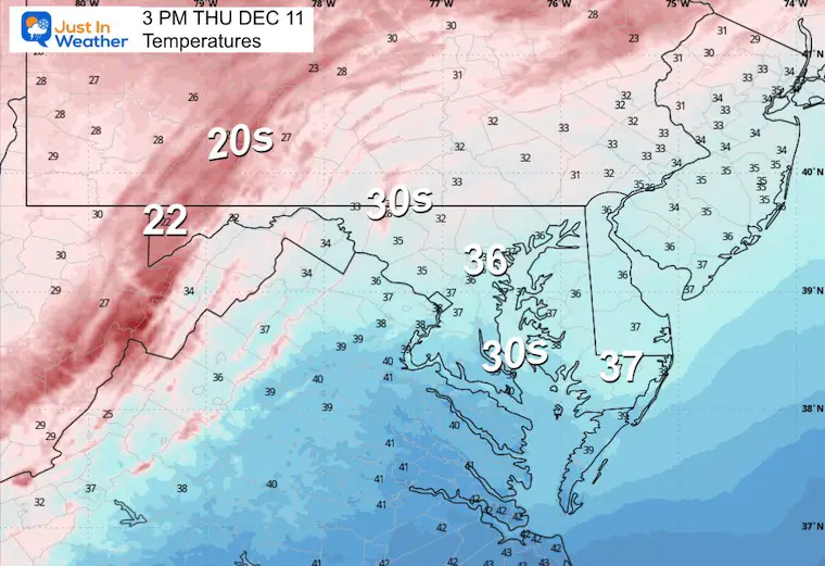
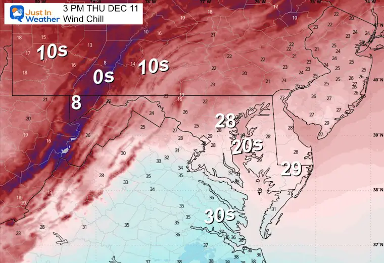
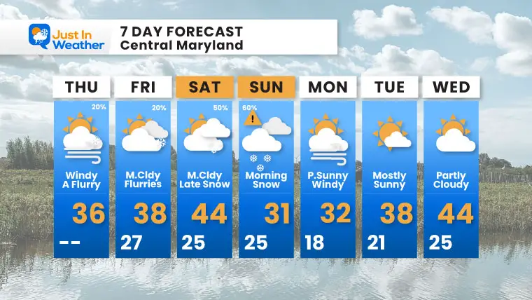
Thursday Morning, December 11
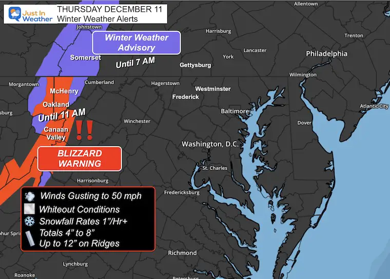
Today will be a windy and cold day across the region. The focus on the Wind Chill applies to the entire region. Meanwhile, in the Blizzard Warning area of far Western Maryland, wind gusts reached 50 mph, most snow fell overnight.
Snow has fallen and will continue, but not at the intensity originally forecast.
Some of those winds are carrying flurries our way this morning. So a few ambient flakes may reach your area.
The main event will be the second of two clippers swinging through. Snow is expected to accumulate across Central Maryland and the surrounding regions overnight Saturday into Sunday morning.
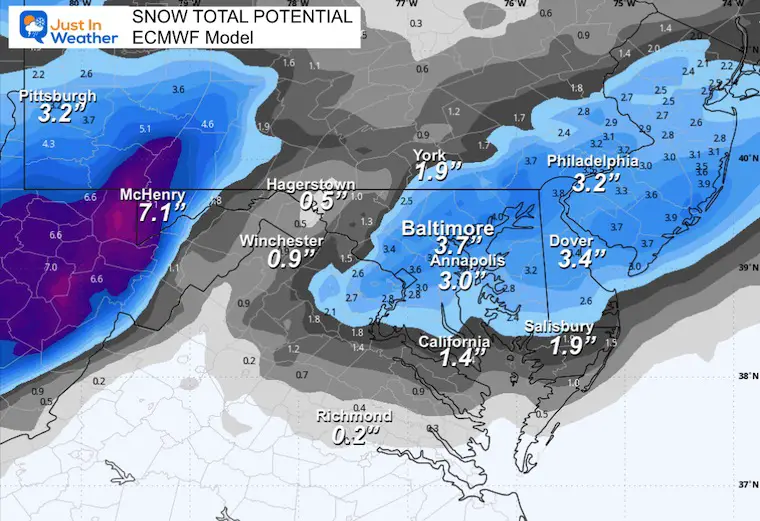
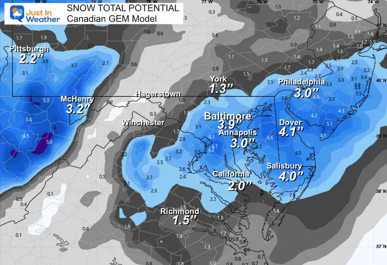
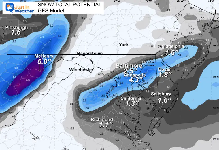
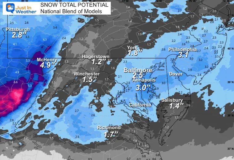
Below is a look at my go-to simulation AND 4 computer model snow forecast maps to compare and contrast.
Wisp Ski Resort at Deep Creek Lake in McHenry Maryland.
This webcam is positioned at The Greene Turtle Deep Creek Lake and shows Wisp Resort, including a zoomed-in view of Squirrel Cage, The Face, the terrain park, Boulder, the mountain coaster, the tubing park and a shot of McHenry Cove at Deep Creek Lake!
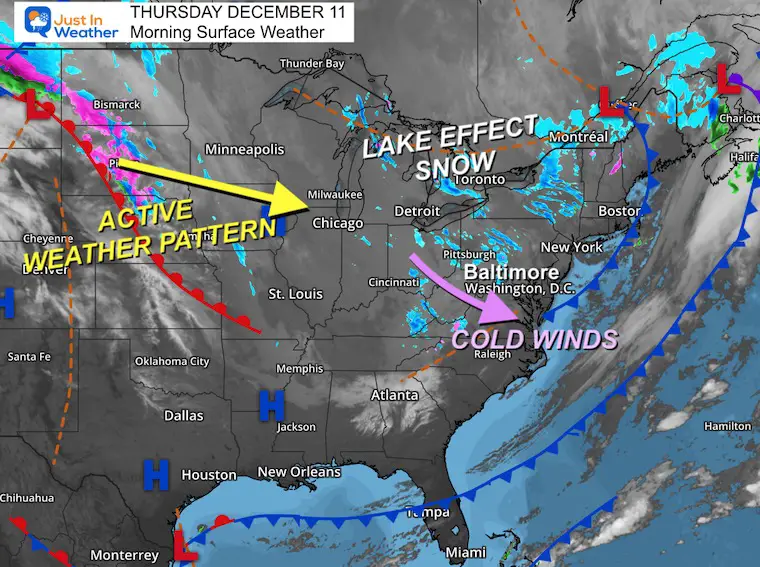
Strong cold winds are producing Lake Effect Snow. Some of those showers and flurries are crossing the mountains.
Light snow showers north of Fredrick near Emmitsburg and Carroll Valley (Ski Liberty).
These are moving to the Southeast on the strong winds…
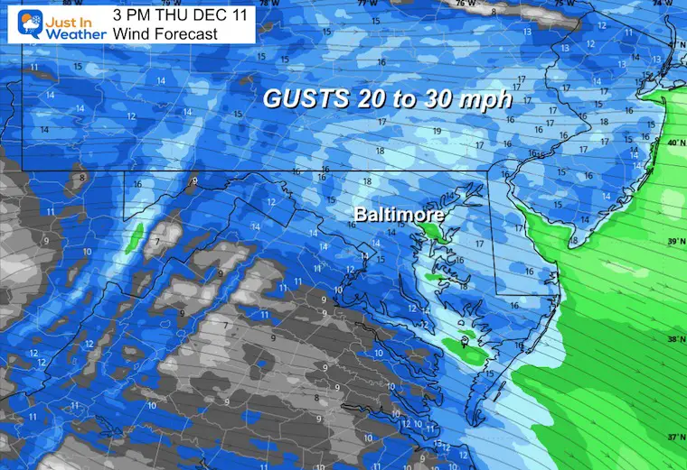
Flurries are likely across the Western and Northern suburbs of Baltimore this morning.
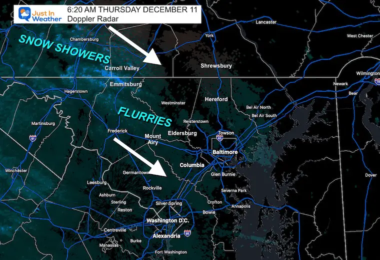
A few flurries may cross the mountains this morning. These will not show up well on radar.
Gusts 20 to 30 mph.
Yesterday: Low 30F; High 45F
Precipitation: 0.00”
Snow = 0
Season Snow Total: 1.0″
Top Wind Gust: 25 mph
Sunrise at 7:16 AM
Sunset at 4:44 PM
Normal Low in Baltimore: 31ºF
Record 9ºF in 1968
Normal High in Baltimore: 49ºF
Record 70ºF
Rainfall Deficit at BWI
Subscribe for eMail Alerts
Sign up and be the first to know!

The first clipper we were tracking will pass to our south. Expect a mix of clouds and maybe some flurries.
The focus will be on the second of the two clippers. Here we see it develop right over our region. This is a Lee Trough, where a complex set of circumstances enhances the atmosphere on the side of the mountains as it moves away.
This will undergo some enhancement with the temperature and baroclinic zone along the coast, which will flare up over the ocean. This is why we expect it to throw back snow along the coast into the afternoon and spread into southern New England as well.
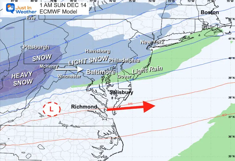
This will begin near or after midnight Saturday into Sunday
Developing light snow…
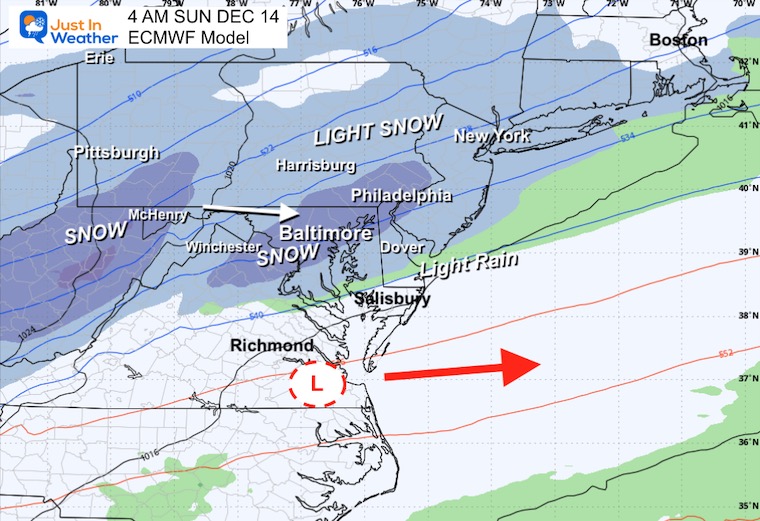
Steady snow should be accumulating at this time.
Moderate to heavy snow at times.
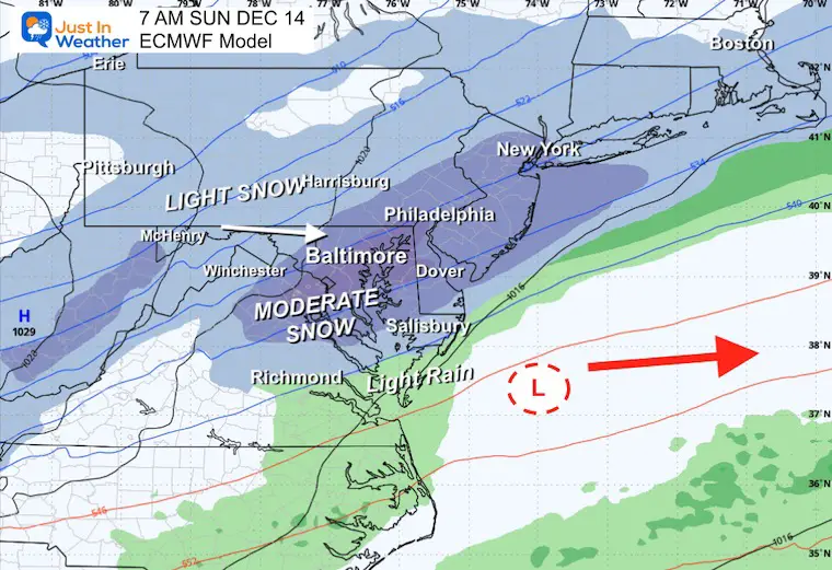
The peak impact expands across Central Maryland through Delmarva.
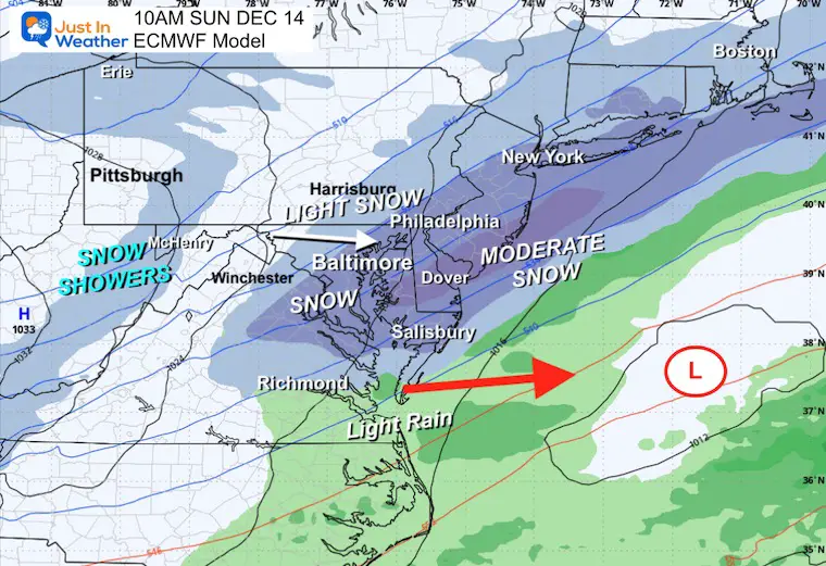
Moving off the coast with snow winding down to showers and flurries.

THE BOOST to 70% for Baltimore on the ECMWF Model is based on 50 different simulations.
There is still some variation, and I CAUTION AGAINST locking in on the highest number. It is prudent and best practice to consider the range and lean towards the middle.
Today and Tomorrow: Cold Winds; Some Flurries
Snow Event: Late Saturday Night Through Sunday Morning
Warming? Temps get to the 40s next Wednesday, which is still below average.
Subscribe for eMail Alerts
Sign up and be the first to know!
In case you missed it. The brief summary of the final snow totals from the last event.

Click here for the full report

This was issued October 9, as expected: A weak and short-lived event to start winter may play a different role this winter.

These are NOT all the same caterpillar!


Click to see more and ‘Book’ a visit to your school


The annual event: Hiking and biking 329 miles in 7 days between The Summit of Wisp to Ocean City.
Each day, we honor a kid and their family’s cancer journey.
Fundraising is for Just In Power Kids: Funding Free Holistic Programs. I never have and never will take a penny. It is all for our nonprofit to operate.
Click here or the image to donate:

I am aware there are some spelling and grammar typos and occasional other glitches. I take responsibility for my mistakes and even the computer glitches I may miss. I have made a few public statements over the years, but if you are new here, you may have missed it: I have dyslexia and found out during my second year at Cornell University. It didn’t stop me from getting my meteorology degree and being the first to get the AMS CBM in the Baltimore/Washington region. One of my professors told me that I had made it that far without knowing and to not let it be a crutch going forward. That was Mark Wysocki, and he was absolutely correct! I do miss my mistakes in my own proofreading. The autocorrect spell check on my computer sometimes does an injustice to make it worse. I can also make mistakes in forecasting. No one is perfect at predicting the future. All of the maps and information are accurate. The ‘wordy’ stuff can get sticky. There has been no editor who can check my work while writing and to have it ready to send out in a newsworthy timeline. Barbara Werner is a member of the web team that helps me maintain this site. She has taken it upon herself to edit typos when she is available. That could be AFTER you read this. I accept this and perhaps proves what you read is really from me… It’s part of my charm. #FITF