


My Call For Snowfall Saturday Morning Inland And Sunday Closer To The Coast
Friday Evening Update January 16 2026 Two weather events will bring snow to our region this weekend. They are related to the fast winds aloft on the edge of this…
Friday December 5
Afternoon Update
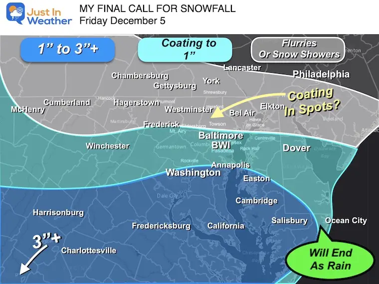
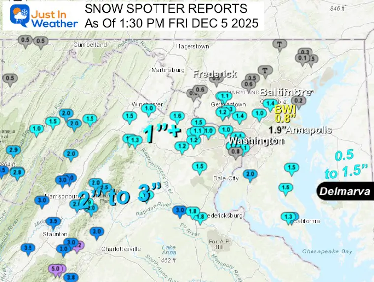
This little weather system has been a big headache even though it did perform almost exactly as expected. The light snow created road problems across parts of Central and Southern Maryland today. Snow totals are preliminary, but the map and list below match very well with my forecast.
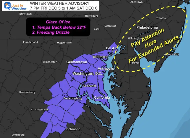
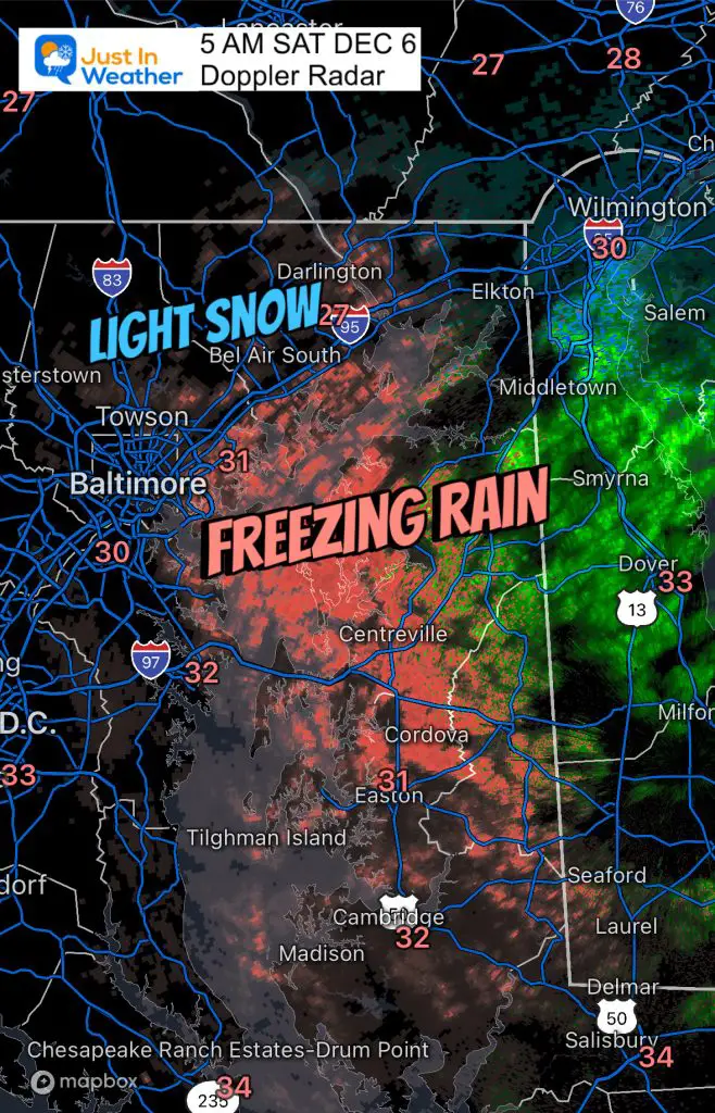
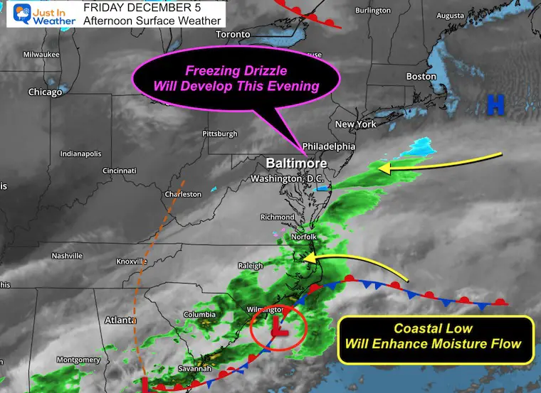
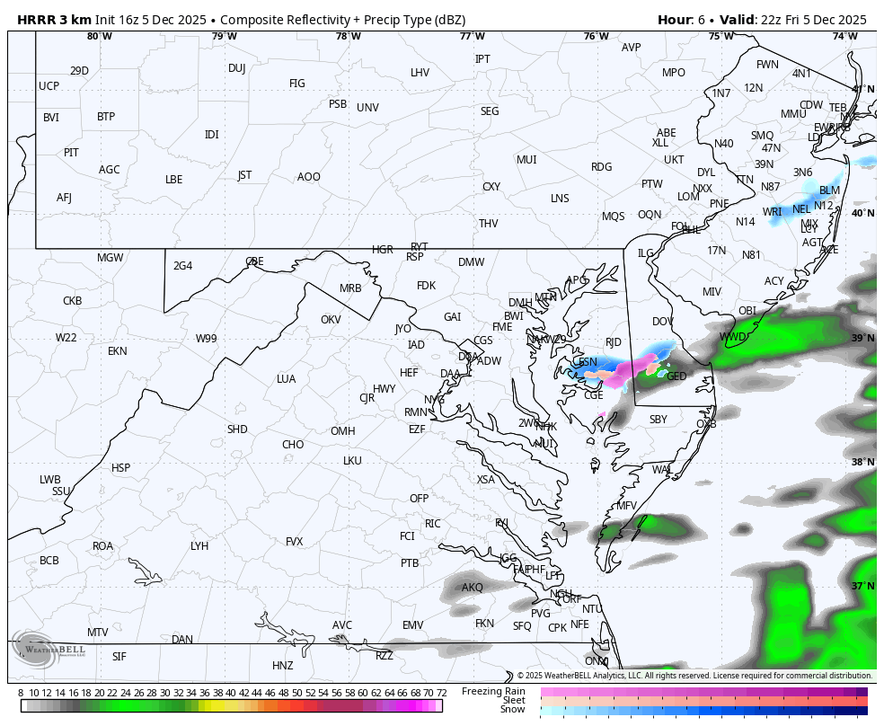
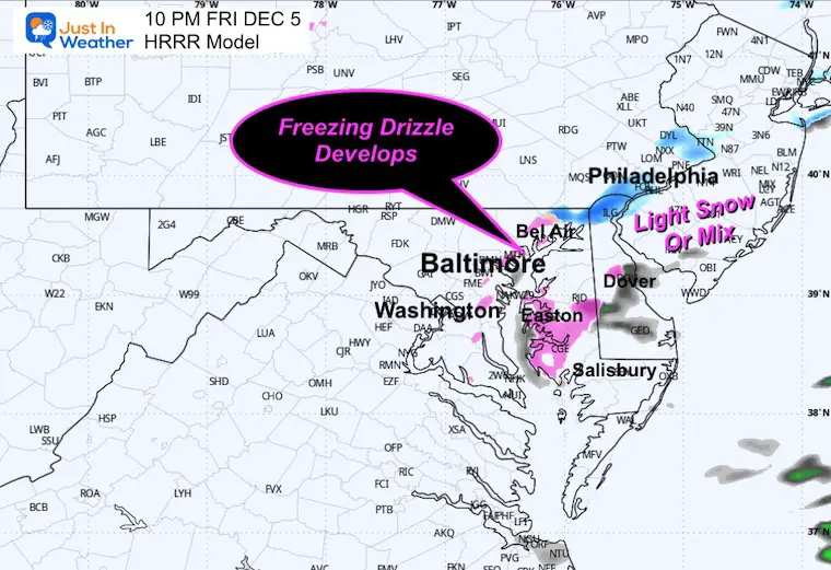
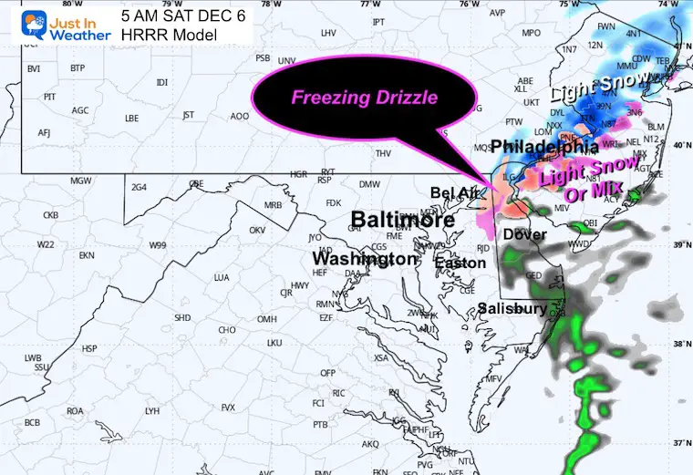
The next phase is just evidence that this has been trying very hard to max its potential. The Coastal Low will get a little enhancement tonight, allowing for a band of light freezing rain or drizzle to form. This will be in addition to wet pavement that will freeze with the cold temperatures.
The National Weather Service has posted A NEW Winter Weather Advisory for Maryland and Virginia for a glaze of ice. I see support that Delmarva and metro Philadelphia into New Jersey should watch closely for the possibility they get their own Advisory as well.
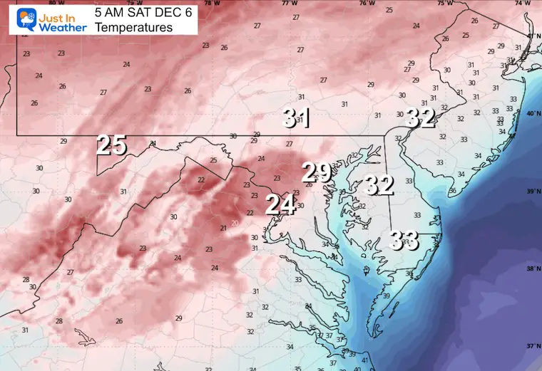
Confirmed Icing and Snow This Morning
Low Pressure on the coast near Wilmington, NC, will strengthen just enough to work with High Pressure in the Atlantic to increase the flow of moist air onshore.
The upper level dynamic supports a band of light freezing rain or freezing drizzle to develop this evening and overnight.
5 PM Fri to 5 AM Sat
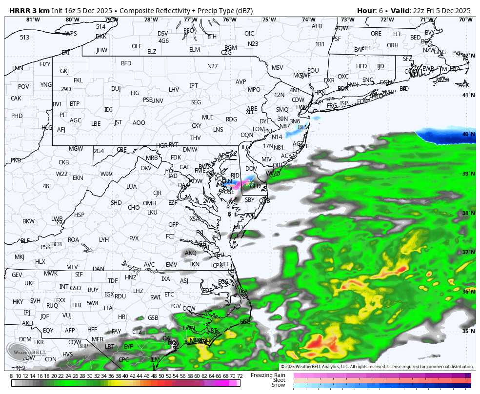
(This model performed best with today’s snow)
5 PM Fri to 5 AM Sat
Do you remember the decade of first snows on this date? It was also how Faith in the Flakes began with my son.
Baltimore and snow BWI stats
The preliminary report looks VERY CLOSE to my forecast map. Compare here. I will have a full recap later.
See the list from spotters by county below:
MARYLAND
…Anne Arundel County…
Churchton 1 ENE 2.0 1230 PM 12/05 Trained Spotter
Crownsville 3 SSW 1.9 1200 PM 12/05 Trained Spotter
Crofton 1 SSE 1.5 1127 AM 12/05 NWS Employee
Odenton 1 N 1.5 1045 AM 12/05 CoCoRaHS
Crofton 2 NNE 1.2 107 PM 12/05 NWS Employee
Severn 1.0 1121 AM 12/05 Public
Bwi Airport 0.8 100 PM 12/05 Official NWS Obs
…Baltimore County…
Perry Hall 1 NNE 0.5 1215 PM 12/05 Trained Spotter
Glyndon 1 WSW 0.4 1251 PM 12/05 Trained Spotter
Cockeysville 2 NNW 0.3 1221 PM 12/05 Broadcast Media
Edgemere 0.2 1052 AM 12/05 Trained Spotter
Bentley Springs 1 E T 1130 AM 12/05 Trained Spotter
…Calvert County…
Chesapeake Beach 4 S 1.8 1258 PM 12/05 Amateur Radio
Prince Frederick 1 S 1.5 1000 AM 12/05 Trained Spotter
…Carroll County…
Eldersburg 1 ESE 0.5 935 AM 12/05 Trained Spotter
Gamber 1 WNW 0.3 1215 PM 12/05 CoCoRaHS
…Cecil County…
Woodlawn 2 ENE T 1255 PM 12/05 Trained Spotter
…Charles County…
Waldorf 2 W 2.0 935 AM 12/05 Trained Spotter
…Frederick County…
Adamstown 1 ESE 0.6 1000 AM 12/05 NWS Employee
…Garrett County…
Oakland 0.5 1039 AM 12/05 Dept of Highways
Grantsville 5 W 0.5 1038 AM 12/05 Dept of Highways
Grantsville 4 E 0.5 1040 AM 12/05 Dept of Highways
…Harford County…
Bel Air 2 NE 0.5 1140 AM 12/05 Broadcast Media
Chrome Hill 2 SE 0.3 1122 AM 12/05 Trained Spotter
…Howard County…
Elkridge 1.4 1140 AM 12/05 NWS Employee
Laurel 2 N 1.0 1200 PM 12/05 Trained Spotter
Gaither 2 SE 0.6 1200 PM 12/05 Trained Spotter
…Montgomery County…
Gaithersburg 1.5 935 AM 12/05 Emergency Mngr
Norbeck 1 ESE 1.5 1245 PM 12/05 Trained Spotter
Gaithersburg 2 E 1.5 1129 AM 12/05 NWS Employee
Washington Grove 1 N 1.3 1000 AM 12/05 Trained Spotter
Damascus 3 SSW 1.2 1003 AM 12/05 Co-Op Observer
Gaithersburg 1 SW 1.2 1015 AM 12/05 Trained Spotter
Bradley Farms 1 SSW 1.0 1044 AM 12/05 NWS Employee
…St. Marys County…
California 2 W 2.2 1125 AM 12/05 Trained Spotter
Ridge 1 E 2.0 1030 AM 12/05 Trained Spotter
California 3 W 1.8 940 AM 12/05 Trained Spotter

VIRGINIA
…Albemarle County…
Earlysville 3 NW 3.0 1028 AM 12/05 Trained Spotter
…Arlington County…
Rosslyn W 1.7 1100 AM 12/05 Trained Spotter
Baileys Crossroads 1 1.6 1110 AM 12/05 Trained Spotter
Barcroft 1 WNW 1.4 946 AM 12/05 Trained Spotter
Reagan National Apt 1.1 1000 AM 12/05 Official NWS Obs
…Augusta County…
Summerdean 3 SE 3.5 1041 AM 12/05 Broadcast Media
Greenwood 3 NNW 3.0 1145 AM 12/05 Public
Afton 1 WNW 3.0 1150 AM 12/05 Public
…City of Alexandria…
Alexandria 1 W 1.1 100 PM 12/05 Trained Spotter
Alexandria 1 ENE 1.1 100 PM 12/05 Trained Spotter
…City of Charlottesville…
Charlottesville 2 SW 2.0 1030 AM 12/05 Broadcast Media
…City of Fredericksburg…
Dunavant 1 S 3.0 1000 AM 12/05 Trained Spotter
Fredericksburg 2 E 1.8 1150 AM 12/05 Trained Spotter
…Clarke County…
Berryville 1 NNW 1.0 945 AM 12/05 Trained Spotter
…Culpeper County…
Culpeper 1 W 1.4 1015 AM 12/05 Trained Spotter
…Fairfax County…
Fairfax 2.0 1249 PM 12/05 Emergency Mngr
Tantallon 2 W 2.0 1250 PM 12/05 Trained Spotter
Herndon 1 NNE 1.0 1020 AM 12/05 NWS Employee
…Fauquier County…
Greenwich 1 W 1.3 114 PM 12/05 Other Federal
…Frederick County…
Stephens City 2 E 1.5 1030 AM 12/05 Trained Spotter
…Greene County…
Ruckersville 1 WNW 2.8 1230 PM 12/05 Trained Spotter
Stanardsville 2.0 1257 PM 12/05 Trained Spotter
…Highland County…
Monterey 4.0 1209 PM 12/05 Broadcast Media
Hightown 5 NW 3.0 951 AM 12/05 Public
Hightown 3 NW 3.0 953 AM 12/05 Public
…Loudoun County…
Ashburn N 1.5 1000 AM 12/05 Trained Spotter
Arcola 1 NNE 1.3 1040 AM 12/05 Trained Spotter
Arcola 3 S 1.2 1050 AM 12/05 Trained Spotter
Dulles International 1.1 1012 AM 12/05 Official NWS Obs
…Madison County…
Big Meadows 2.5 1141 AM 12/05 Public
…Nelson County…
Wintergreen 5.0 1015 AM 12/05 Law Enforcement
Wintergreen 2 WSW 5.0 1018 AM 12/05 Law Enforcement
Shipman 1 WNW 4.0 1000 AM 12/05 Trained Spotter
Rockfish 2 WNW 3.8 1015 AM 12/05 Trained Spotter
…Page County…
Stanley 2 WSW 2.0 1000 AM 12/05 Trained Spotter
…Prince William County…
Manassas 3 SSE 1.5 1015 AM 12/05 Trained Spotter
…Rappahannock County…
Woodville 1.5 122 PM 12/05 Trained Spotter
…Rockingham County…
Broadway 3.0 1042 AM 12/05 Broadcast Media
Cherry Grove 3.0 948 AM 12/05 Dept of Highways
Swift Run 2.0 1142 AM 12/05 Public
Massanutten 1 SE 2.0 1100 AM 12/05 Trained Spotter
Elkton 1.9 1132 AM 12/05 Public
…Stafford County…
Stafford 3.0 1155 AM 12/05 Trained Spotter
Ramoth 1 WSW 2.2 1250 PM 12/05 Trained Spotter
Fredericksburg 4 NW 1.8 1123 AM 12/05 Public
…Warren County…
Front Royal 1.5 1143 AM 12/05 Public
Linden 3 W 1.3 1037 AM 12/05 Trained Spotter
WEST VIRGINIA
…Grant County…
Petersburg 1.0 1012 AM 12/05 Dept of Highways
…Hardy County…
Bean Settlement 2.0 1054 AM 12/05 Dept of Highways
Baker 2.0 1052 AM 12/05 Dept of Highways
Wardensville 1.5 1055 AM 12/05 Dept of Highways
Moorefield 1.5 1051 AM 12/05 Dept of Highways
…Pendleton County…
Circleville 3.5 1034 AM 12/05 Trained Spotter
Seneca Rocks 2.9 1014 AM 12/05 Public
Franklin 1 N 2.8 939 AM 12/05 Emergency Mngr
Franklin 2.8 947 AM 12/05 Dept of Highways
Subscribe for eMail Alerts
Sign up and be the first to know!
Click here for the full report

This was issued October 9, as expected: A weak and short-lived event to start winter may play a different role this winter.

These are NOT all the same caterpillar!


Click to see more and ‘Book’ a visit to your school


The annual event: Hiking and biking 329 miles in 7 days between The Summit of Wisp to Ocean City.
Each day, we honor a kid and their family’s cancer journey.
Fundraising is for Just In Power Kids: Funding Free Holistic Programs. I never have and never will take a penny. It is all for our nonprofit to operate.
Click here or the image to donate:

I am aware there are some spelling and grammar typos and occasional other glitches. I take responsibility for my mistakes and even the computer glitches I may miss. I have made a few public statements over the years, but if you are new here, you may have missed it: I have dyslexia and found out during my second year at Cornell University. It didn’t stop me from getting my meteorology degree and being the first to get the AMS CBM in the Baltimore/Washington region. One of my professors told me that I had made it that far without knowing and to not let it be a crutch going forward. That was Mark Wysocki, and he was absolutely correct! I do miss my mistakes in my own proofreading. The autocorrect spell check on my computer sometimes does an injustice to make it worse. I can also make mistakes in forecasting. No one is perfect at predicting the future. All of the maps and information are accurate. The ‘wordy’ stuff can get sticky. There has been no editor who can check my work while writing and to have it ready to send out in a newsworthy timeline. Barbara Werner is a member of the web team that helps me maintain this site. She has taken it upon herself to edit typos when she is available. That could be AFTER you read this. I accept this and perhaps proves what you read is really from me… It’s part of my charm. #FITF