


My Call For Snowfall Saturday Morning Inland And Sunday Closer To The Coast
Friday Evening Update January 16 2026 Two weather events will bring snow to our region this weekend. They are related to the fast winds aloft on the edge of this…
Wednesday, December 3 2025
Morning Report
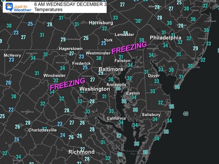
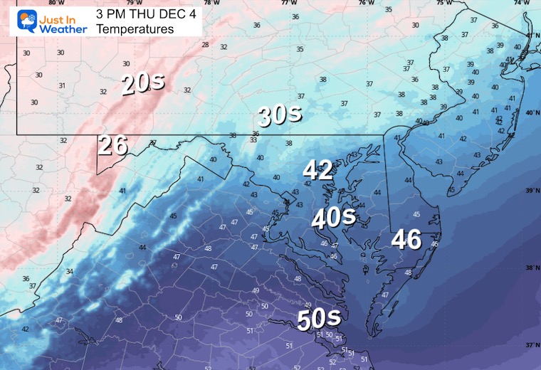
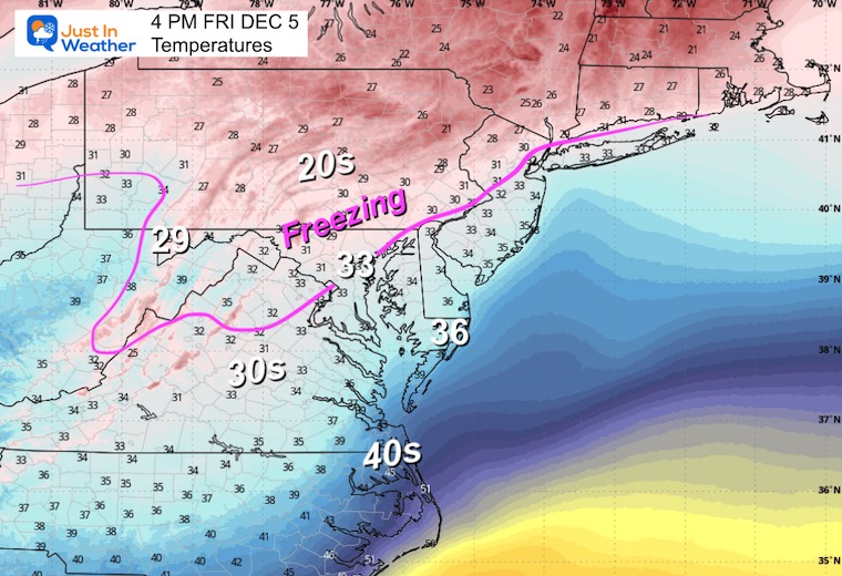
This morning starts off cold and dry, but after the heaviest rainfall in months, it could be a little icy. Widespread temps in the 20s to lower 30s could have resulted in some wet areas last night to freeze.
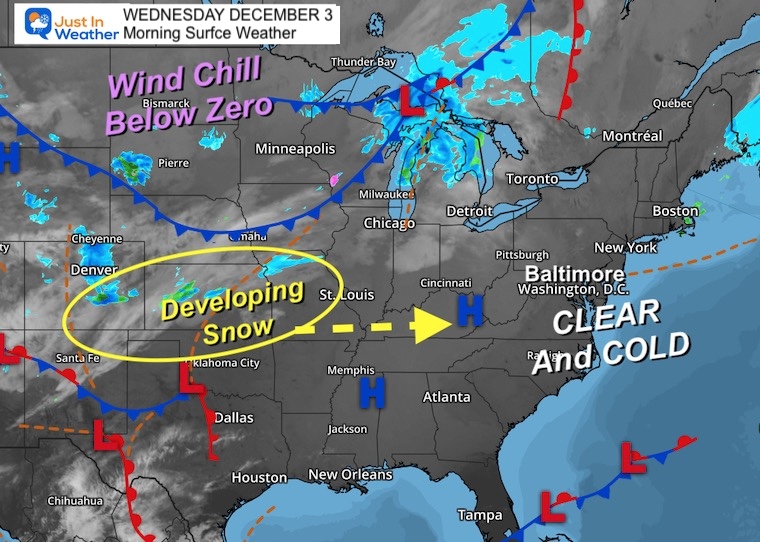
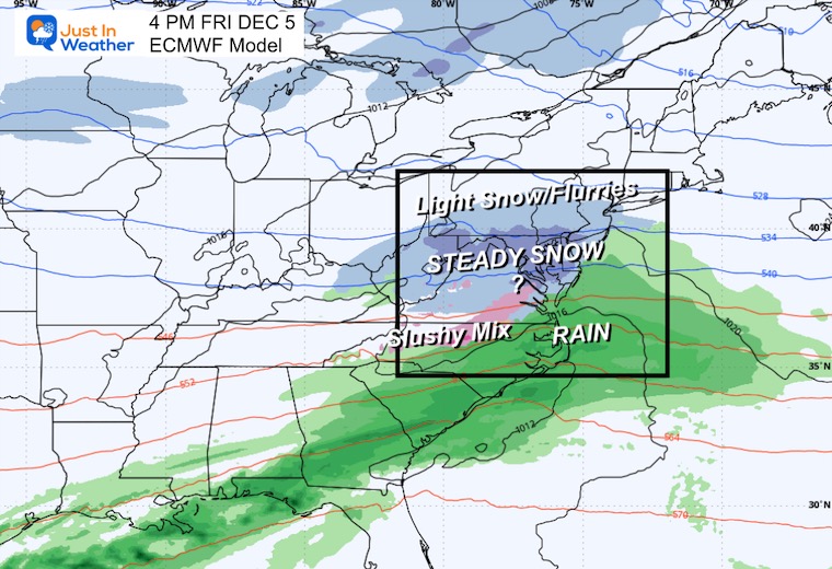
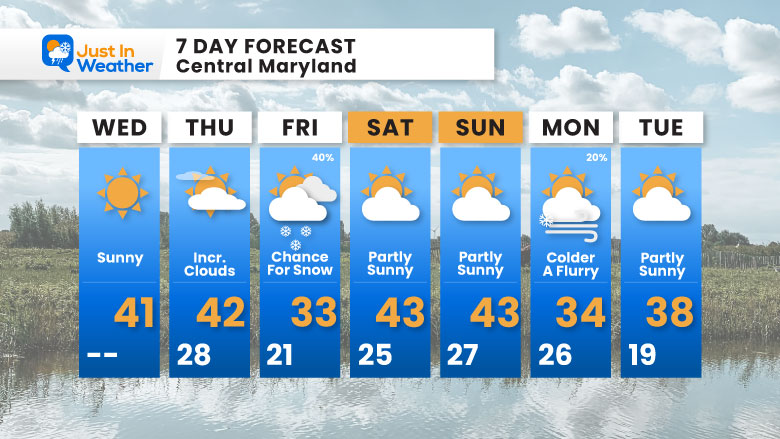
Today and tomorrow will be dry. The next snow event will arrive on Friday. This will be a quick-moving event with a narrow band of steady snow for a few hours. The impact is not a lock yet, but where it does snow, it will be cold enough to stick.
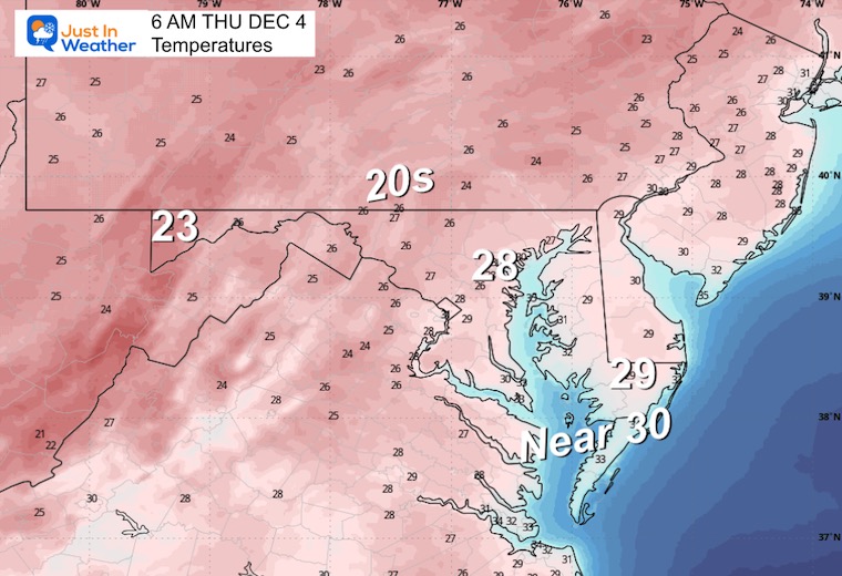
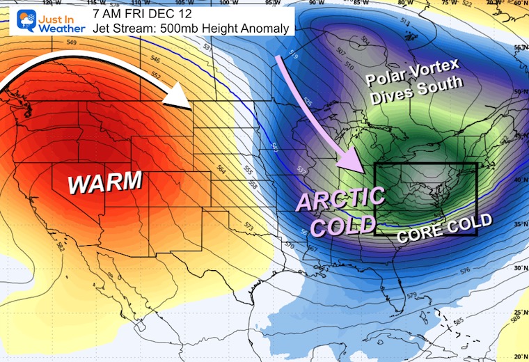
What follows will be multiple reinforcing shots of arctic air. The coldest with a lobe of the stretched Polar Vortex is expected by the end of next week.
I posted this on Facebook last night, as it was the best place to get a simple grading and collective feedback. If you explore closer, my first call was the best. I believe my message about the warm ground was received, but I made some mistakes that accounted for the slush and snow zone shifting about 20 miles farther north and west.
Most of the event yesterday was rain, as expected. The total of 0.84” in Baltimore was the single wettest day since August 13.
I am including this Facebook post as well, just in case you missed it and want to read the comments.
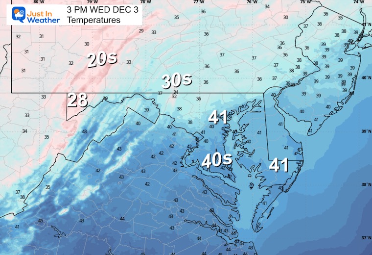
High Pressure is moving into the Eastern US, which will provide us with a sunny day and keep us dry through tomorrow.
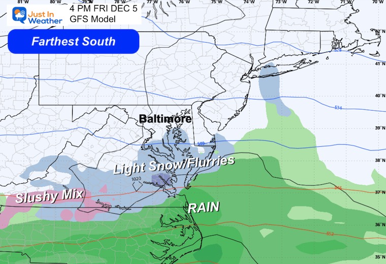
The next area of developing snow will be across the Southern Plains and head to the coast on Friday.
Yesterday: Low 27F; High 40F
Precipitation: 0.84”
Top Wind Gust 25 mph
Sunrise at 7:09 AM
Sunset at 4:44 PM
Normal Low in Baltimore: 32ºF
Record 11ºF in 1976
Normal High in Baltimore: 51ºF
Record 72ºF 1998
Rainfall Deficit at BWI

Subscribe for eMail Alerts
Sign up and be the first to know!
This is a flat or zonal flow. This means that whatever forms will not be strong and will be moving quickly.
This is like shooting an arrow, and a narrow area will get the impact.
Convergence: The focus on the faster winds will be where the light band of snow will form underneath. This will track south of Maryland… but how close is the debate.
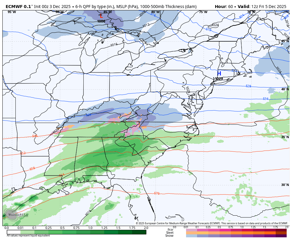
I have been showing the ECMWF Model, and this is the plot that brings the narrow band of steady snow into Central Maryland.
While this has a history of being the most reliable, it was too cold with our recent event. It was also too far south, which adds another question for this track.
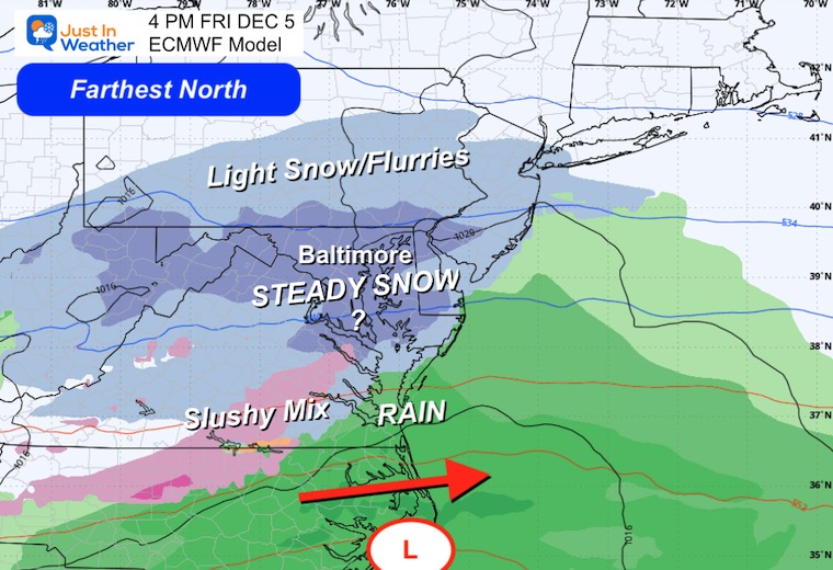
This is the middle track, and farther south. This product does perform at its best in arctic patterns.
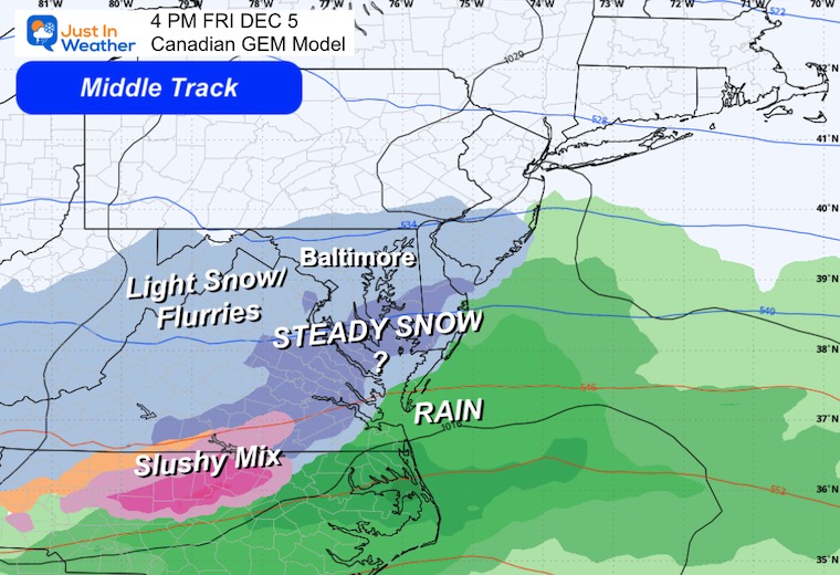
This model is still less reliable. For the last event, it started too strong and too cold. However, it did catch on and do a better job closer to the event.
More cold air will be flowing into the Eastern US.
We can see the Polar Vortex send a lobe of truly arctic air into the Eastern US next week. The second impulse will be the strongest!
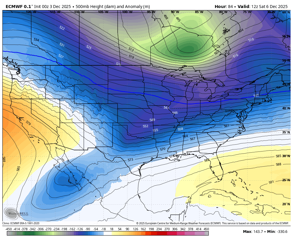
Very cold air arrives, but more intense cold with the Polar Vortex will drop our way late in the week.
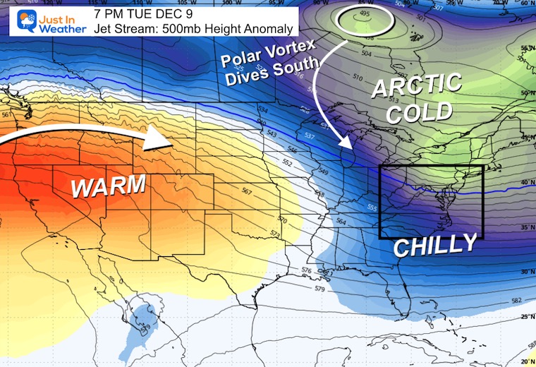
The core of the cold air may result in some records.
Subscribe for eMail Alerts
Sign up and be the first to know!
Click here for the full report

This was issued October 9, as expected: A weak and short-lived event to start winter may play a different role this winter.

These are NOT all the same caterpillar!


Click to see more and ‘Book’ a visit to your school


The annual event: Hiking and biking 329 miles in 7 days between The Summit of Wisp to Ocean City.
Each day, we honor a kid and their family’s cancer journey.
Fundraising is for Just In Power Kids: Funding Free Holistic Programs. I never have and never will take a penny. It is all for our nonprofit to operate.
Click here or the image to donate:

I am aware there are some spelling and grammar typos and occasional other glitches. I take responsibility for my mistakes and even the computer glitches I may miss. I have made a few public statements over the years, but if you are new here, you may have missed it: I have dyslexia and found out during my second year at Cornell University. It didn’t stop me from getting my meteorology degree and being the first to get the AMS CBM in the Baltimore/Washington region. One of my professors told me that I had made it that far without knowing and to not let it be a crutch going forward. That was Mark Wysocki, and he was absolutely correct! I do miss my mistakes in my own proofreading. The autocorrect spell check on my computer sometimes does an injustice to make it worse. I can also make mistakes in forecasting. No one is perfect at predicting the future. All of the maps and information are accurate. The ‘wordy’ stuff can get sticky. There has been no editor who can check my work while writing and to have it ready to send out in a newsworthy timeline. Barbara Werner is a member of the web team that helps me maintain this site. She has taken it upon herself to edit typos when she is available. That could be AFTER you read this. I accept this and perhaps proves what you read is really from me… It’s part of my charm. #FITF