Monday December 1
Afternoon Update
The first winter weather event of the season for the Mid Atlantic will be a quick spin-up of Low Pressure AND a quick mover. The timing allows this to catch the cold air just as it arrives before sunrise. A burst of snow for a few hours will be enough to cover the ground where temperatures are within a few degrees of freezing.
There has been a contradiction that may be confusing. With this inclusion of more (partial) counties also comes a new model guidance, and the NWS forecast lowered totals.
This still fits in my forecast range, and you can compare all the maps below.
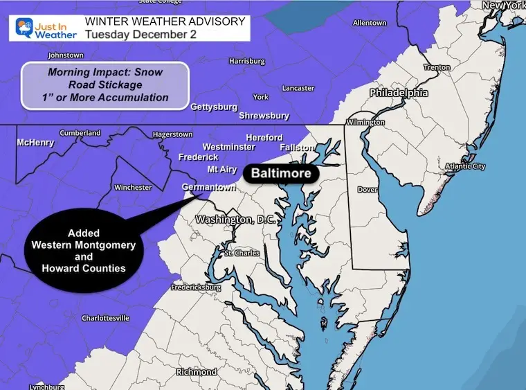
Winter Weather Advisory
- The update here includes Western sections of Montgomery AND Howard Counties.
- Timing 3 AM to 1 PM: This window is likely to get changed, or expire early, as warming is expected mid to late morning.
- This is for areas that are expected to have some impact on the pavement, which in turn may affect schools and the rest of the commute.
- There will be snow in parts of Metro Baltimore, but with warmer ground temperatures, roads are expected to be mostly wet. However, some stickage and minor accumulation on the grass is possible.
Maryland Counties:
Partial Counties: Northern Harford, Northern Baltimore, Western Howard and Western Montgomery
Full Counties: Carroll, Frederick, Washington, Allegheny, Garrett.
Pennsylvania includes Lancaster, York, Adams, and all West and North.
Virginia: Along and West of I-81
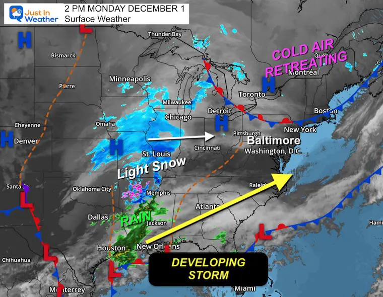
Monday Afternoon Set Up
- A wide area of light snow has been observed from Arkansas to Illinois and Michigan.
- Low Pressure along the Gulf Coast will organize tonight into tomorrow.
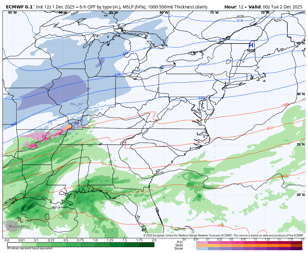
ECMWF Model Animation 7 PM Mon to 7 AM Wed
- This will be a quick spin-up of Low Pressure and a quick mover.
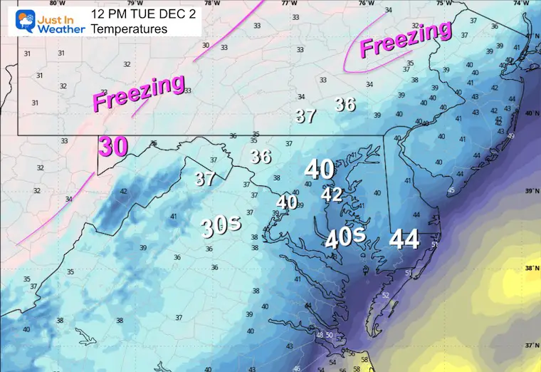
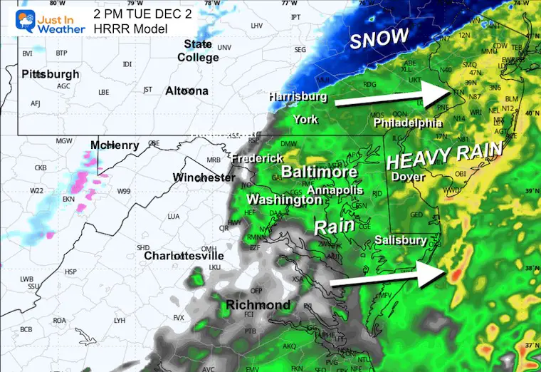
- As I mentioned in my prior reports, there is a lack of Blocking High Pressure to hold the cold, which is why we expect the arrival of snow to transition to rain with the heavier precipitation midday.
Forecast Start Time

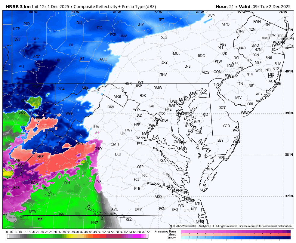
RADAR SIMULATION TUESDAY
4 AM to 6 PM
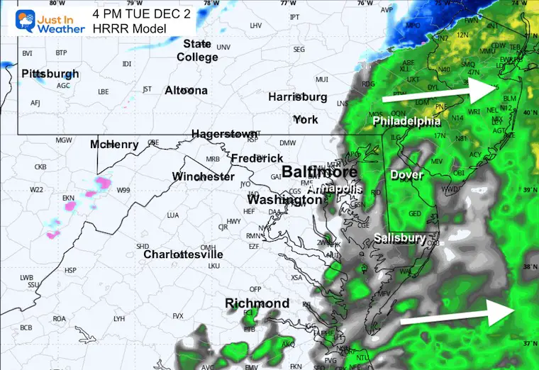
A snow burst will occur during the first few hours, then transition to rain before noon for most areas.
In the snow zone, it may be heavy for a few hours during the morning commute. During the rain period, it may be heavy at times.
Snapshots
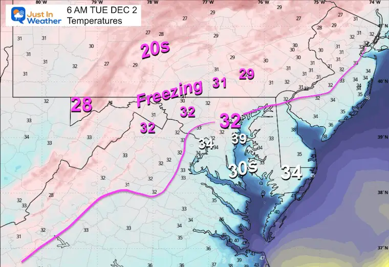
EARLY MORNING
6 AM

Temperatures
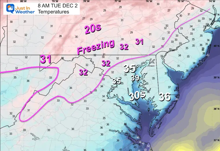
MID MORNING
8 AM

Temperatures
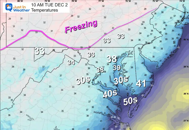
10 AM

Temperatures
MIDDAY
12 PM Noon

Temperatures
2 PM
4 PM
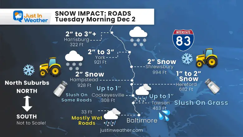
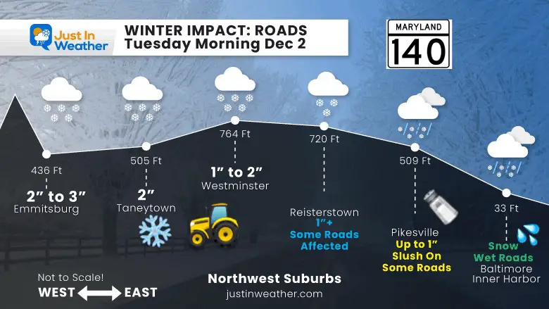
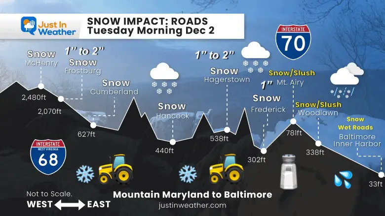
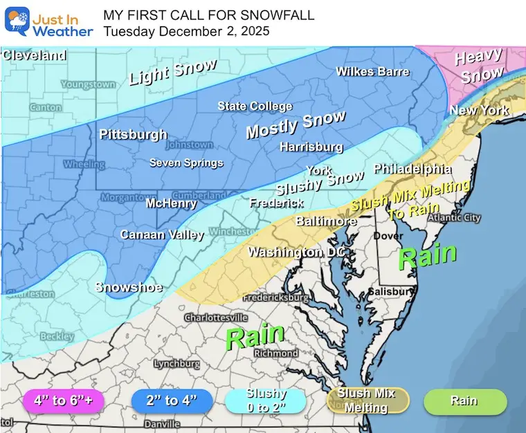
My FINAL Call For Snowfall

Profiles: Road Impact Based On My Call For Snowfall
North Side Of Baltimore
I-83
Northwest Suburbs of Baltimore
MD 140
Maryland Between Baltimore and the Mountains
I-68 and I-70
With winter events, the most attention is often given to snowfall and totals. This early-season event has a few obstacles for the Mid-Atlantic that I want to emphasize.
Factors That Conflict And May Play A Role:
NOT ALL SNOW THAT FALLS WILL STICK
I am still concerned with the surface temperature that will be slightly above freezing in the city and around I-95.
Timing the arrival before sunrise may allow for a burst of heavier intensity to lay and stay before any solar energy can influence.
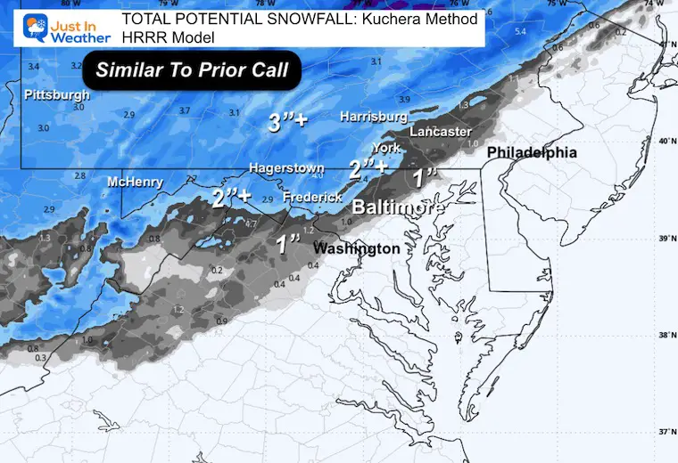
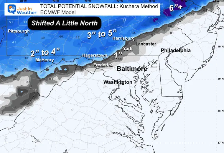
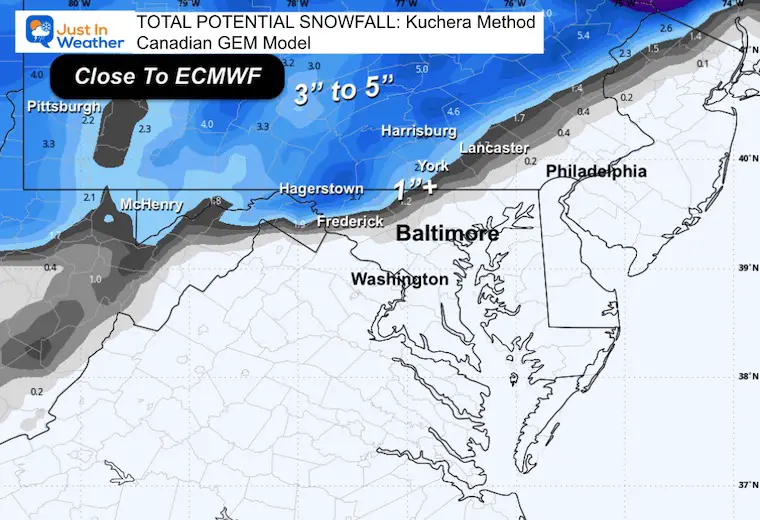
Snowfall Potential Totals
I used the Kuchera Method that accounts for compacting and melting…
HRRR Model
This is similar to the last plot I showed you and is within the range of my forecast.
ECMWF Model
This has shifted the snow line a little farther north, but keeps the 1-inch line close to Frederick and Westminster.
Canadian GEM Model
This has shifted south and is now similar to the European Model.
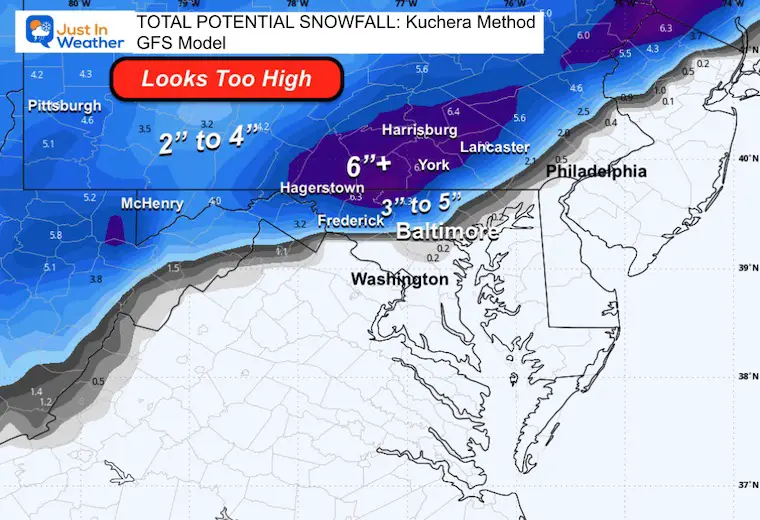
GFS Model
This is the most aggressive with the heaviest snow.
I am not sure who takes this model seriously anymore. It has been all over the place, and I do not trust it.
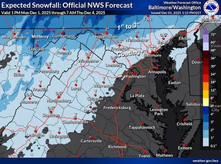
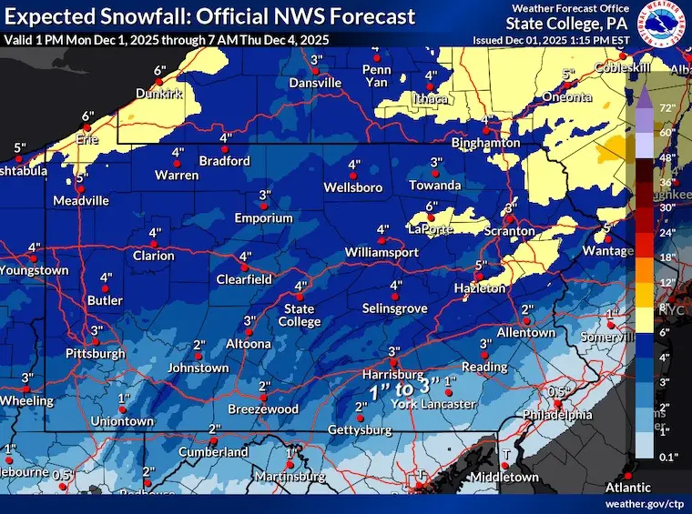
National Weather Service Forecasts
Maryland and Virginia
Pennsylvania
My SECOND CALL From Yesterday
Wider View
Subscribe for eMail Alerts
Faith in the Flakes Store Open

My Winter Outlook For Above-Average Snow
Click here for the full report

La Niña Advisory
This was issued October 9, as expected: A weak and short-lived event to start winter may play a different role this winter.

In Case You Missed It
Woolly Bear Caterpillar Winter Folklore
These are NOT all the same caterpillar!

Winter Outlook From 2 Farmers’ Almanacs

STEM Assemblies/In School Fields Trips Are Back
Click to see more and ‘Book’ a visit to your school

THANK YOU:
Baltimore Sun Magazine Readers’ Choice Best Of Baltimore

Maryland Trek 12 Day 7 Completed Sat August 9
UPDATED: We raised OVER $166,000 for Just In Power Kids – AND Still Collecting More
The annual event: Hiking and biking 329 miles in 7 days between The Summit of Wisp to Ocean City.
Each day, we honor a kid and their family’s cancer journey.
Fundraising is for Just In Power Kids: Funding Free Holistic Programs. I never have and never will take a penny. It is all for our nonprofit to operate.
Click here or the image to donate:

RESTATING MY MESSAGE ABOUT DYSLEXIA
I am aware there are some spelling and grammar typos and occasional other glitches. I take responsibility for my mistakes and even the computer glitches I may miss. I have made a few public statements over the years, but if you are new here, you may have missed it: I have dyslexia and found out during my second year at Cornell University. It didn’t stop me from getting my meteorology degree and being the first to get the AMS CBM in the Baltimore/Washington region. One of my professors told me that I had made it that far without knowing and to not let it be a crutch going forward. That was Mark Wysocki, and he was absolutely correct! I do miss my mistakes in my own proofreading. The autocorrect spell check on my computer sometimes does an injustice to make it worse. I can also make mistakes in forecasting. No one is perfect at predicting the future. All of the maps and information are accurate. The ‘wordy’ stuff can get sticky. There has been no editor who can check my work while writing and to have it ready to send out in a newsworthy timeline. Barbara Werner is a member of the web team that helps me maintain this site. She has taken it upon herself to edit typos when she is available. That could be AFTER you read this. I accept this and perhaps proves what you read is really from me… It’s part of my charm. #FITF
Please share your thoughts and best weather pics/videos, or just keep in touch via social media.


