


Winter Weather Advisory Sunday As Snowfall In Two Parts Affecting Two Different Areas
Saturday Evening Update January 17 2026 One thing I carry after all of my years of forecasting: If one model does a really good job in an active pattern, then…
Thursday, November 20, 2025
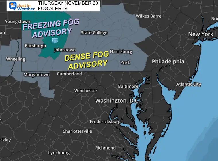
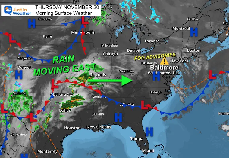
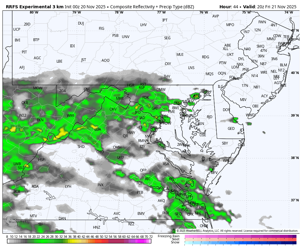
The atmosphere remains in an ambiguous manner, with leftover moisture holding the clouds. Low-level moisture has prompted Fog Advisories in Pennsylvania that include a rare Freezing Fog Advisory in the mountains near Pittsburgh. Head’s up if traveling there.
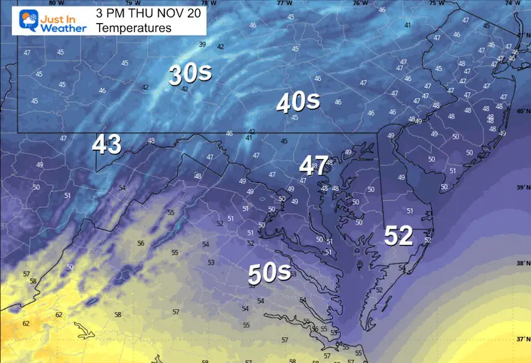
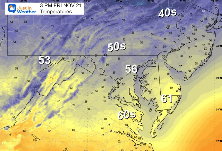
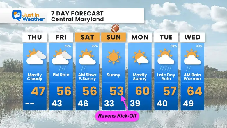
After another chilly day, the next weather system will follow the pattern of arriving later in the day and dropping most of the rain overnight. So our weekend will improve, especially with sun on Sunday and a warm-up to near 60°F early next week.
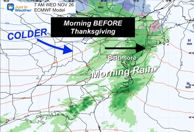
Another system will race here next week on the edge of the warm air and arctic blast to follow. At this point, the rain may be limited to Wednesday morning, before Thanksgiving.
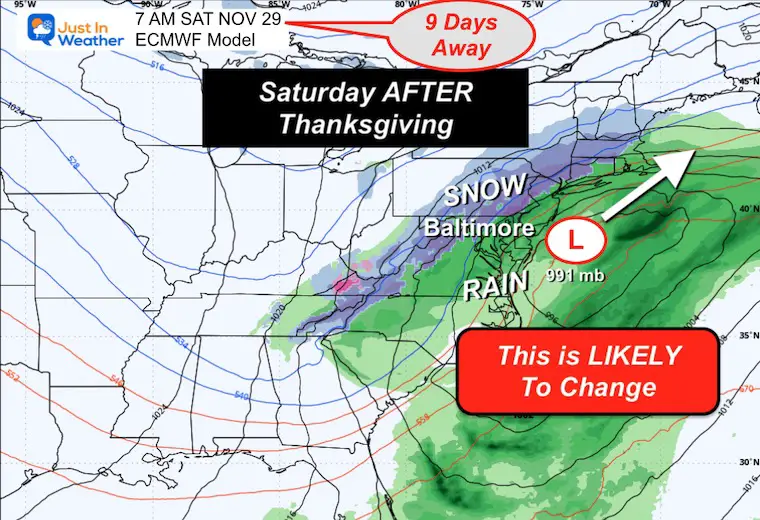
The first taste of arctic air will arrive by the end of next week into the holiday weekend, and we have a signal for a coastal storm and interior snow that I URGE CAUTION when seeing, since it is 9 days away.
This is for travelers in Pennsylvania. Freezing Fog in the mountains near Pittsburgh.
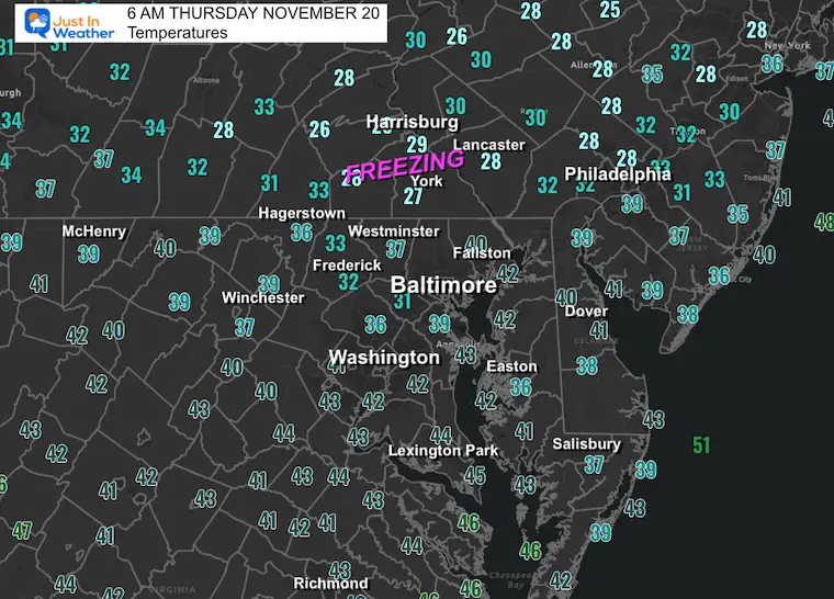
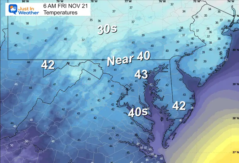
HOWEVER, the temps at 6 AM are below freezing around York, Harrisburg, and Lancaster. Just be a little careful in these areas, and you might have ice to scrape off your windshield.
Yesterday: Low 41F; High 48F
Precipitation: 0.15” (2-Day Storm Total 0.45”)
Sunrise at 6:56 AM
Sunset at 4:49 PM
Normal Low in Baltimore: 35ºF
Record 22ºF in 1951; 2022
Normal High in Baltimore: 56ºF
Record 79ºF 1942
Rainfall Deficit at BWI
Click here for the full report

Subscribe for eMail Alerts
Sign up and be the first to know!
The next round of rain will be approaching from the West. It may reach the mountains of Western Maryland and extend into southern Virginia.
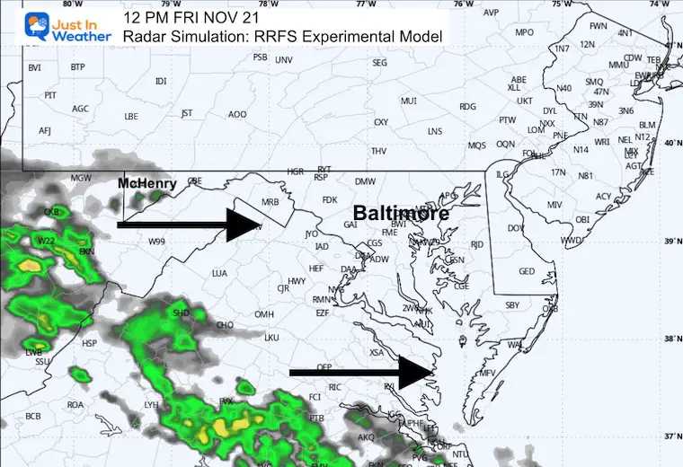
Much like the last event, we will watch for rain showers to reach metro areas late in the day. Most of the rain will fall overnight.
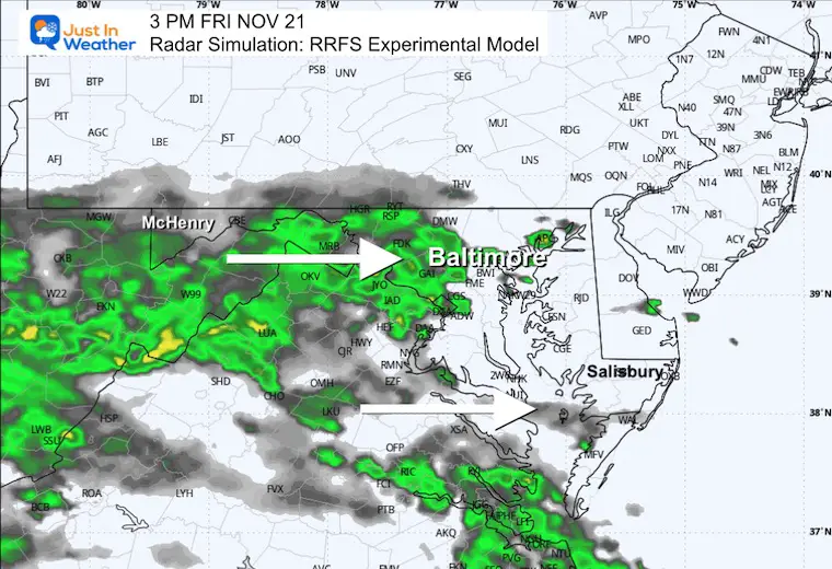
Showers will develop by the afternoon. We seem to be in a pattern with most expected to fall overnight. They end by Saturday morning, setting us up for an improvement to follow.
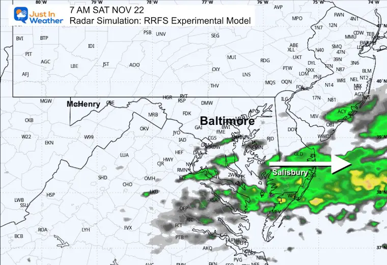
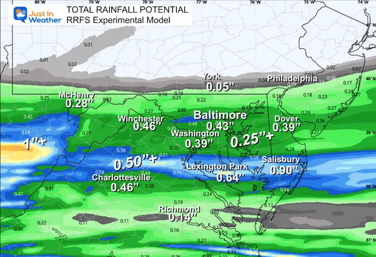
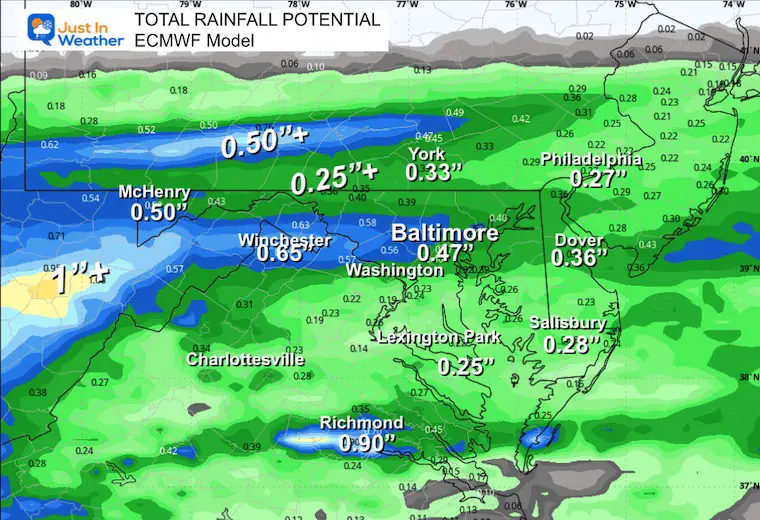
Another quick-moving rain event is likely to time out early in the day, followed by a warm-up.
(Thanksgiving Weekend)
Thanksgiving may be our transition day, then the first push of arctic air arrives next Friday.
This may spark a coastal storm, followed by mild air, and then the NEXT FULL LOAD of arctic air will arrive in the first week of December.
PLEASE NOTE: This is 9 Days Away
IT is very likely that this will change, so if you see this map somewhere else, take note that the accuracy for storms increases within 7 days, and even then, I hold off on legitimate snow chances and totals to within 3 days.
Subscribe for eMail Alerts
Sign up and be the first to know!
This was issued October 9, as expected: A weak and short-lived event to start winter may play a different role this winter

These are NOT all the same caterpillar!


Click to see more and ‘Book’ a visit to your school


The annual event: Hiking and biking 329 miles in 7 days between The Summit of Wisp to Ocean City.
Each day, we honor a kid and their family’s cancer journey.
Fundraising is for Just In Power Kids: Funding Free Holistic Programs. I never have and never will take a penny. It is all for our nonprofit to operate.
Click here or the image to donate:

I am aware there are some spelling and grammar typos and occasional other glitches. I take responsibility for my mistakes and even the computer glitches I may miss. I have made a few public statements over the years, but if you are new here, you may have missed it: I have dyslexia and found out during my second year at Cornell University. It didn’t stop me from getting my meteorology degree and being the first to get the AMS CBM in the Baltimore/Washington region. One of my professors told me that I had made it that far without knowing and to not let it be a crutch going forward. That was Mark Wysocki, and he was absolutely correct! I do miss my mistakes in my own proofreading. The autocorrect spell check on my computer sometimes does an injustice to make it worse. I can also make mistakes in forecasting. No one is perfect at predicting the future. All of the maps and information are accurate. The ‘wordy’ stuff can get sticky. There has been no editor who can check my work while writing and to have it ready to send out in a newsworthy timeline. Barbara Werner is a member of the web team that helps me maintain this site. She has taken it upon herself to edit typos when she is available. That could be AFTER you read this. I accept this and perhaps proves what you read is really from me… It’s part of my charm. #FITF