Sunday, November 9, 2025
Yesterday may have been the last 70°F day in Baltimore for the year. We are still mild, but stepping down.
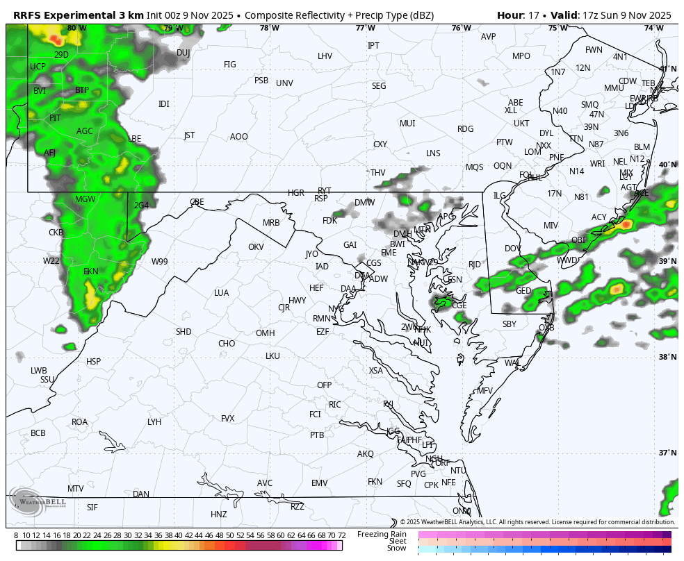
Rain showers this morning are the reason the Bay Bridge Run was cancelled. It was deemed unsafe to have two-way traffic on one span in wet weather. Safety trumps the thousands of disappointed, now non-participants.
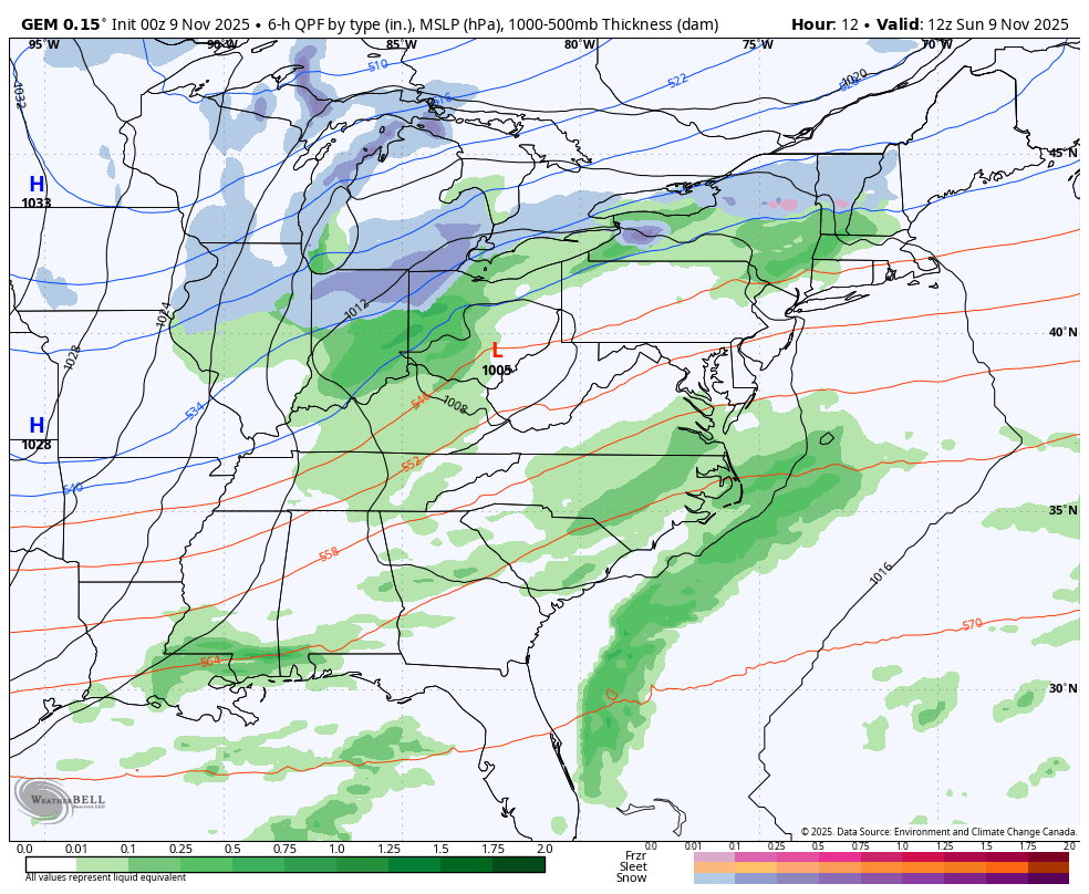
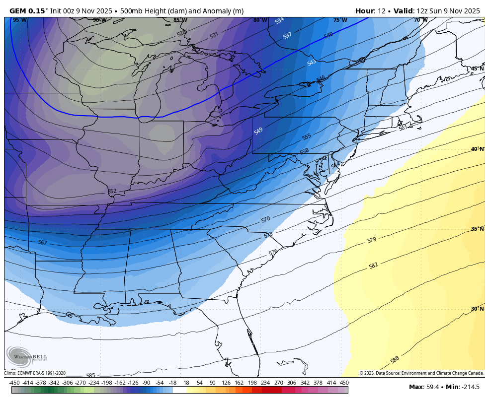
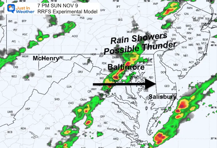
We will have many dry hours today, then heavier rain with possible thunder this evening. A cold front will arrive as a new wave of Low Pressure, along it could enhance the precipitation. This may be a signal of the energy to be followed in the cold air.
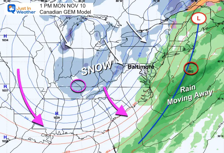
The pre-season winter blast will bring snow to the mountains overnight and through Tuesday Morning. Flurries may pass into metro areas before sunrise on Tuesday.
While the pattern relaxes during the week, there will continue to be an active pattern with more cold impulses to our north.
Let’s take a look:
Live Radar Widget
WEATHER TODAY
Surface Weather
A cluster of rain showers has reached our region, and is the reason the Bay Bridge Run was cancelled.
They will wind down by mid-day, then the next push of rain or even a thunderstorm will arrive with the cold front by evening.
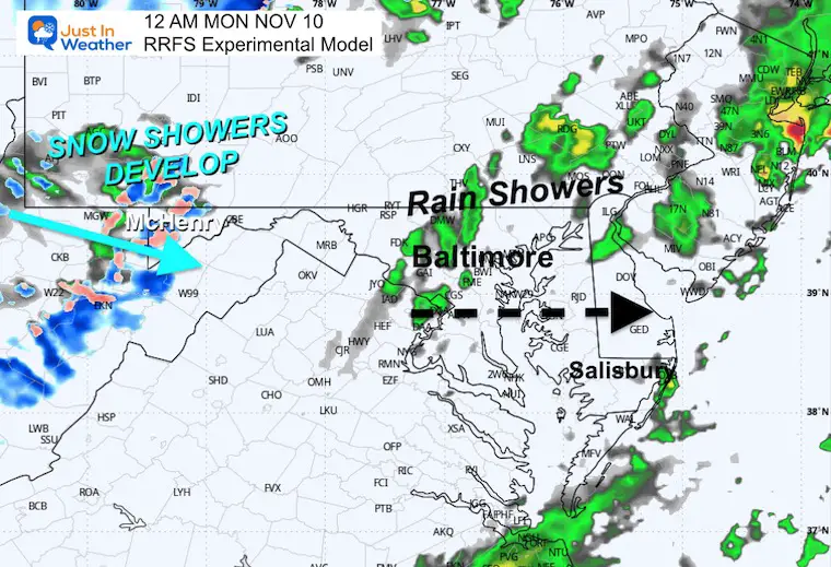
The region of snow will increase as the arctic air expands South and East.

Quick Cast
Storm Forecast Sunday Morning to Tuesday Morning
Jet Stream Through Tuesday Morning
Snapshots
Monday Surface Forecast
A cold front will move off the coast. A wave of Low Pressure may develop on the front to enhance the rain as it arrives.
The snow will be falling in the mountains as much colder air will dive to the Gulf Coast first.
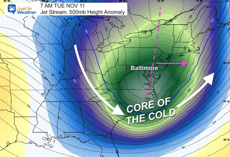
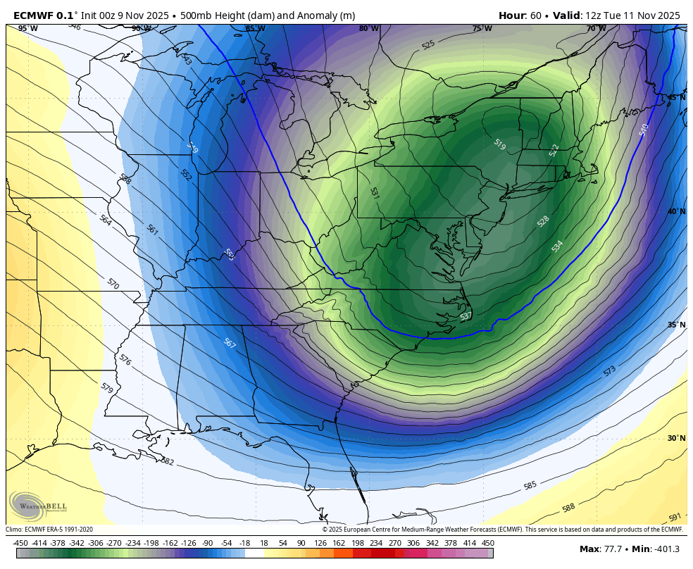
Tuesday Morning Jet Stream
The core of the cold air will pass our region at this time.

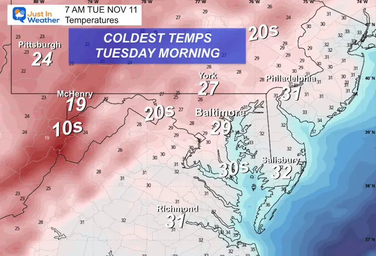
Tuesday Morning Temperatures
The temps will be colder in the Deep South (below freezing) than in eastern New England.
The near-freezing temperatures may damage crops.
FORECAST TODAY
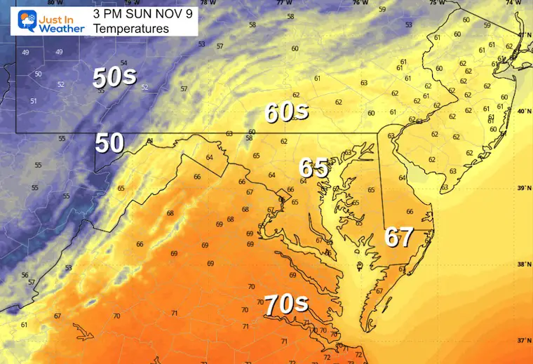
Afternoon Temperatures
Radar Simulation Noon to Midnight
Showers will move to our north, then the next push of rain with possible squall line and thunder will approach from the west in the evening.
Evening Snapshot
Night Snapshot
CLIMATE DATA: Baltimore
Yesterday: Low 47F; High 70F
Precipitation: 0.24”
TODAY November 9
Sunrise at 6:44 AM
Sunset at 4:57 PM
Normal Low in Baltimore: 38ºF
Record 24ºF in 2019
Normal High in Baltimore: 60ºF
Record 78ºF 1994
Rainfall Deficit at BWI
- Ending 2024 = -8.00”
- Since Jan 1 = 5.71”
- We are STILL DOWN -13.71” INCLUDING LAST YEAR
My Winter Outlook For Above-Average Snow
Click here for the full report

Subscribe for eMail Alerts
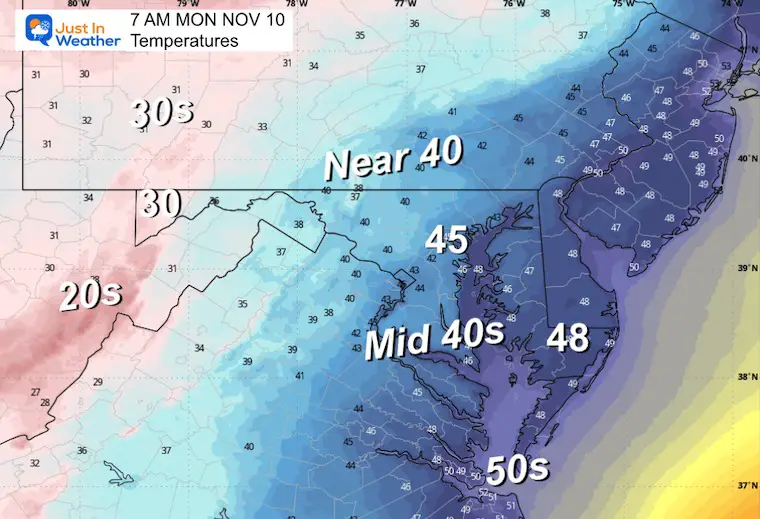
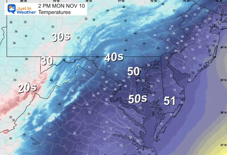
MONDAY
Morning Temperatures
Afternoon Temperatures
Radar Simulation 7 AM to Midnight
Snow bands will develop in the mountains and may accumulate all day. Models do not do a good job handling this, so the representation here is a suggestion and NOT a promise.
Evening Radar Snapshot
Moderate to heavy snow at times will be masked by strong, gusty winds.

TUESDAY FOCUS:
Radar Midnight to Noon
Snow showers in the mountains will gradually fade as the upper-level energy shifts east. This may carry a pocket of rain/snow showers across metro Washington into Southern Maryland BEFORE sunrise.
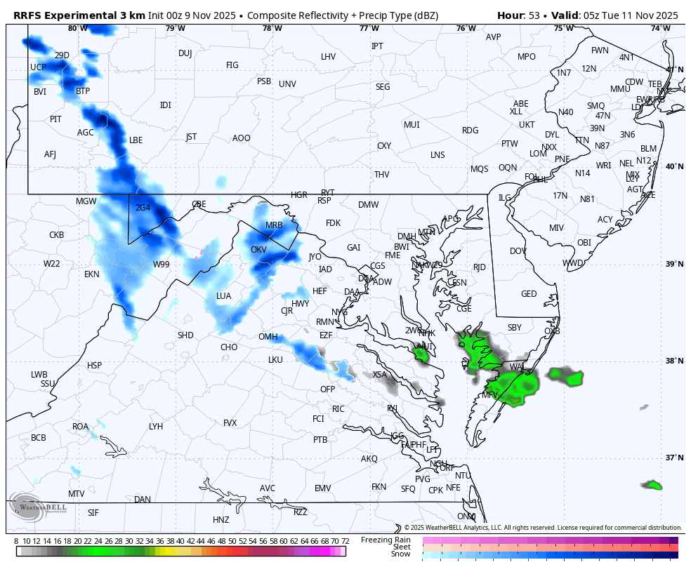
3 AM Snapshot
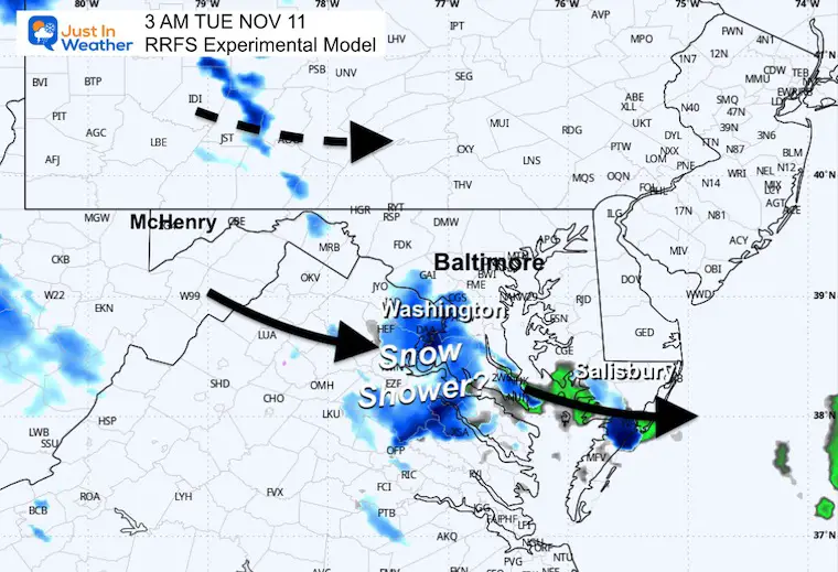
7 AM Snapshot

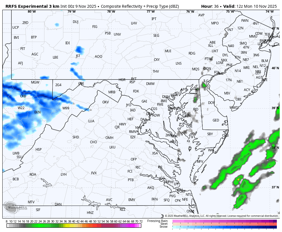
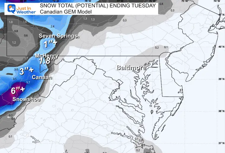
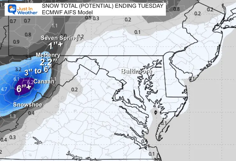
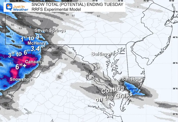
Snow Potential:
Comparing Three Models From Lowest To Highest
Canadian GEM
ECMWF AI Model
RRFS Experimental Model
Tuesday Morning Low Temperatures
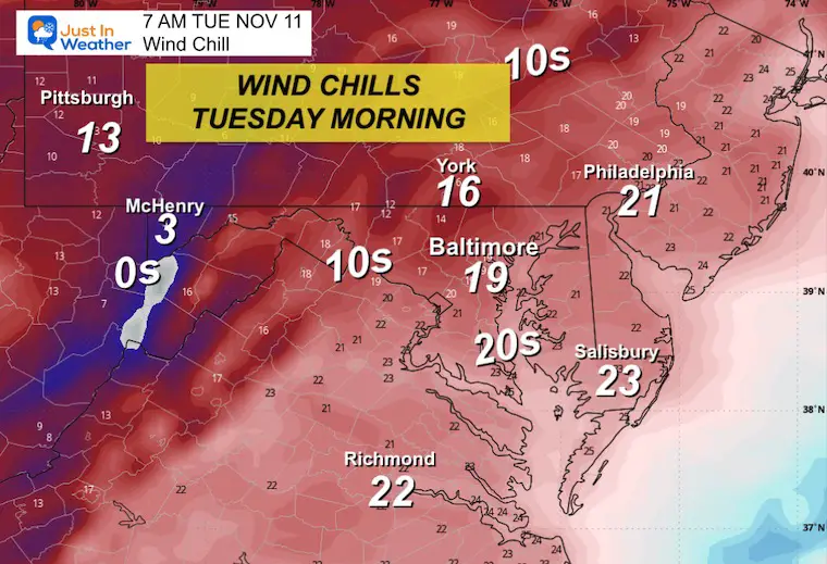
Tuesday Morning Wind Chill
Jet Stream: Tuesday to Sunday
The core of the cold air swings through Tuesday. There will be reinforcing hits through the week, but it will gradually relax as the focus of cold transit shifts north.
The warm-up will reach the Central US while we remain slightly cooler than average.
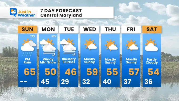
7 Day Forecast
- Today: Periods of rain
- Mountain snow late tonight through Tuesday
- Next Week: Coldest air Tuesday; snow flurries may reach Central and Southern Maryland
- It will be COLDER inland, and snow accumulates in the mountains.
- Dry and below average, the rest of the week
Subscribe for eMail Alerts
Average First Frost

La Niña Advisory
This was issued October 9, as expected: A weak and short-lived event to start winter may play a different role this winter

In Case You Missed It
Woolly Bear Caterpillar Winter Folklore
These are NOT all the same caterpillar!

Winter Outlook From 2 Farmers’ Almanacs

STEM Assemblies/In School Fields Trips Are Back
Click to see more and ‘Book’ a visit to your school

THANK YOU:
Baltimore Sun Magazine Readers’ Choice Best Of Baltimore

Maryland Trek 12 Day 7 Completed Sat August 9
UPDATED: We raised OVER $166,000 for Just In Power Kids – AND Still Collecting More
The annual event: Hiking and biking 329 miles in 7 days between The Summit of Wisp to Ocean City.
Each day, we honor a kid and their family’s cancer journey.
Fundraising is for Just In Power Kids: Funding Free Holistic Programs. I never have and never will take a penny. It is all for our nonprofit to operate.
Click here or the image to donate:

RESTATING MY MESSAGE ABOUT DYSLEXIA
I am aware there are some spelling and grammar typos and occasional other glitches. I take responsibility for my mistakes and even the computer glitches I may miss. I have made a few public statements over the years, but if you are new here, you may have missed it: I have dyslexia and found out during my second year at Cornell University. It didn’t stop me from getting my meteorology degree and being the first to get the AMS CBM in the Baltimore/Washington region. One of my professors told me that I had made it that far without knowing and to not let it be a crutch going forward. That was Mark Wysocki, and he was absolutely correct! I do miss my mistakes in my own proofreading. The autocorrect spell check on my computer sometimes does an injustice to make it worse. I can also make mistakes in forecasting. No one is perfect at predicting the future. All of the maps and information are accurate. The ‘wordy’ stuff can get sticky. There has been no editor who can check my work while writing and to have it ready to send out in a newsworthy timeline. Barbara Werner is a member of the web team that helps me maintain this site. She has taken it upon herself to edit typos when she is available. That could be AFTER you read this. I accept this and perhaps proves what you read is really from me… It’s part of my charm. #FITF
Please share your thoughts and best weather pics/videos, or just keep in touch via social media.


