Tuesday, November 4, 2025
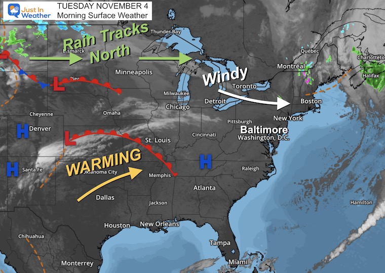
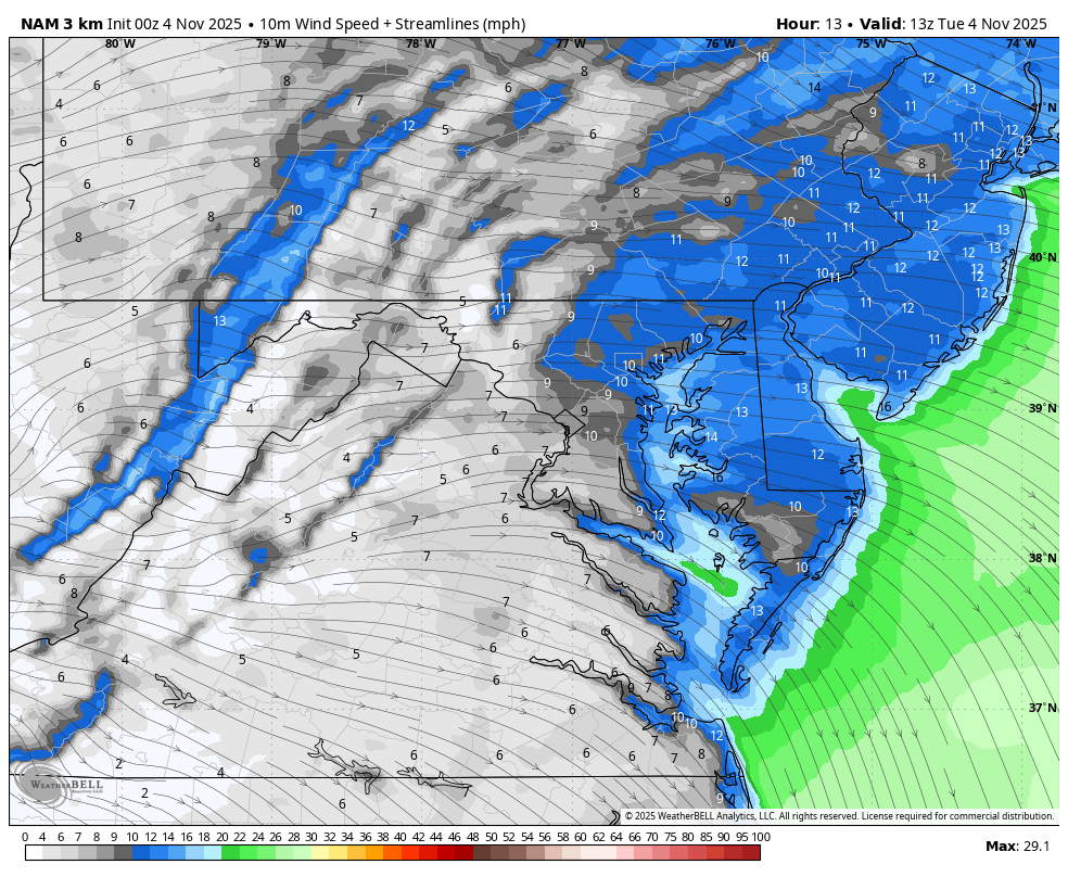
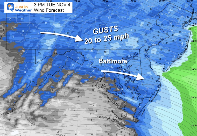
Today is an off-year Election Day, which means this matters to some, but not all of our region. The weather will not be a factor as we expect near-seasonal temps with more sun. However, there will be gusty winds.
This will be an active week that brings the warmest air on Wednesday with a chance that some areas get close to 70F, followed by a drop to the 50s on Thursday afternoon.
A series of cold fronts now brings the rain with the focus on both weekend days. This will be followed by a dramatic early-season arctic air mass. It will feel like winter next week!
Looking further ahead, the jet stream shows an early winter signal NEXT WEEK that could bring the first snow of the season to the mountains of far western Maryland and West Virginia.
Super Moon: The Full Beaver Moon
This is the 2nd Super Moon of 4 in a row. This one will be the closest and brightest as we will be able to see it appearing full this evening and tomorrow.
Moon Rise Times in Baltimore:
-
- Today 4:14 PM
- Tomorrow 4:50 PM

WEATHER TODAY
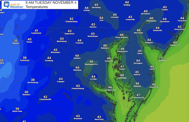
Morning Temperatures
Surface Weather
Wind Forecast 7 AM to 7 PM
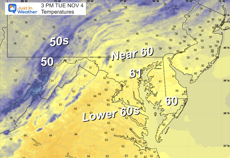
Afternoon Snapshot at 3 PM
High Temperatures
CLIMATE DATA: Baltimore
Yesterday: Low 45F; High 66F
Precipitation: 0.00
TODAY November 4
Sunrise at 6:38 AM
Sunset at 5:02 PM
Normal Low in Baltimore: 40ºF
Record 22ºF in 1951
Normal High in Baltimore: 62ºF
Record 83ºF 1974
Rainfall Deficit at BWI
- Ending 2024 = -8.00”
- Since Jan 1 = 5.47”
- We are STILL DOWN -13.47” INCLUDING LAST YEAR
Subscribe for eMail Alerts
WEDNESDAY
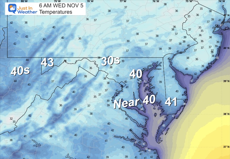
Morning Temperatures
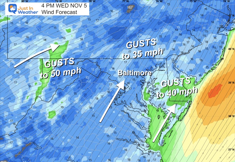
Afternoon Wind Forecast
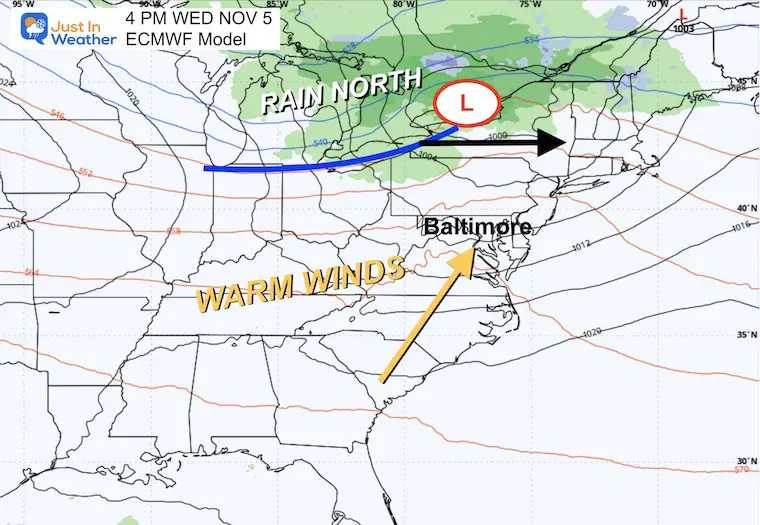
A steady flow FROM THE SOUTH will help pump in some late-season warmth.
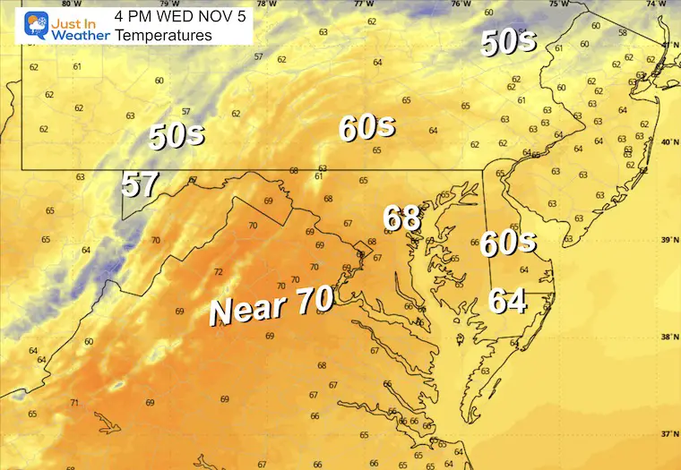
Afternoon Temperatures
Our Warmest Day of the Week – Upper 60s to near 70°F.
Wide View Weather
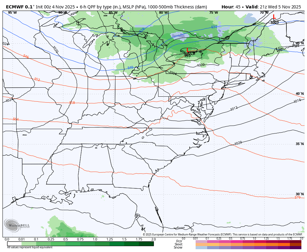
The warm winds will be streaming ahead of the first of several cold fronts. This first one will keep the rain north of our region, but the winds will shift and bring a marked and brief cool down on Thursday.
WEATHER TREND: Wednesday to Next Monday
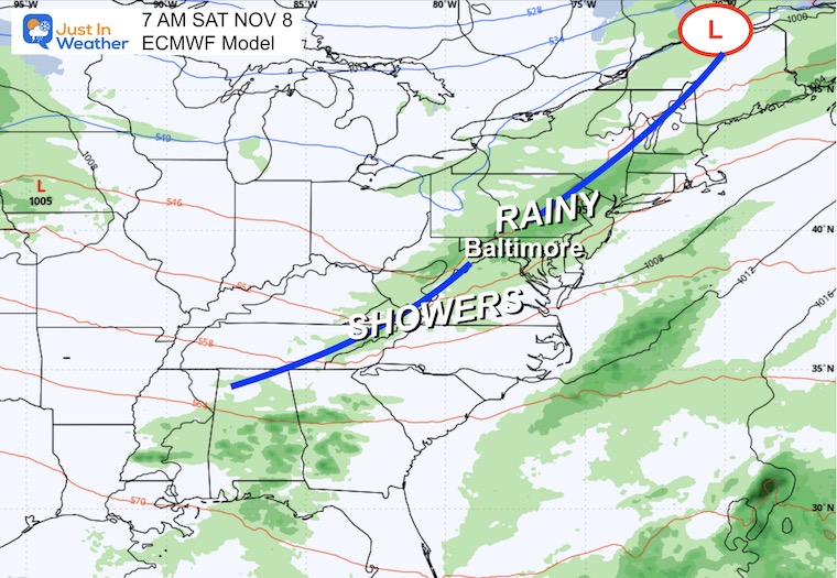
Saturday Morning
This is looking more wet!
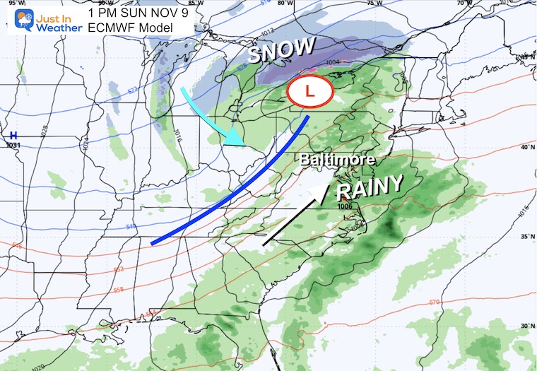
Sunday Afternoon
More showers.
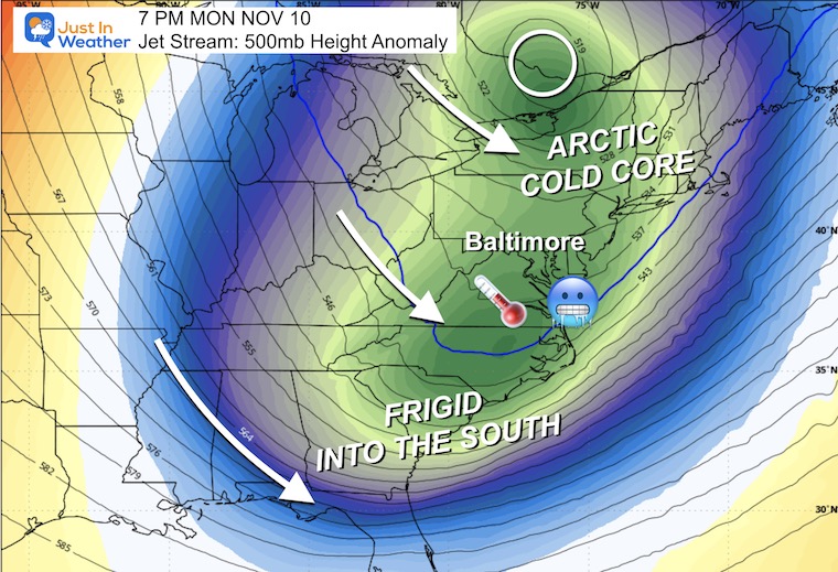
Jet Stream: Monday Evening
This Deep Trough will dig deep into the Deep South!
The core of the cold air will be in New England, and it will feel like winter.
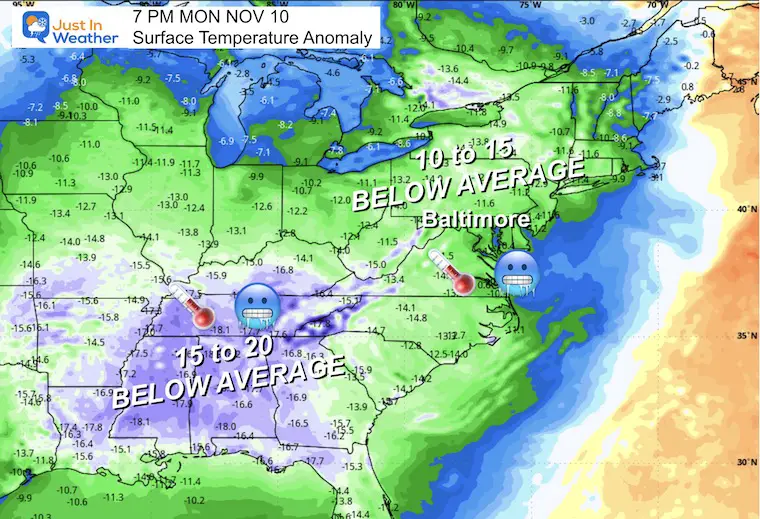
Temperature Anomaly
This is the comparison to ‘average’, and our region will be 10 to 15 degrees COLDER!
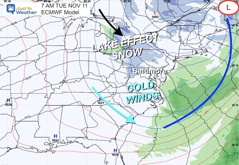
Tuesday Morning
Lake Effect Snow is likely to bring some accumulation to the mountains of Western Maryland, Pennsylvania, and West Virginia.
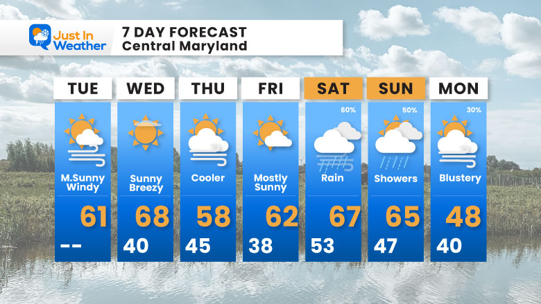
7 Day Forecast
- Today: Mostly Sunny and Windy
- Tomorrow: Warmest Day This Week
- Rain Events: Saturday and Sunday
- Next Week: The Leading Edge of Cold Air – just arriving on Monday.
Subscribe for eMail Alerts
Average First Frost

La Niña Advisory
This was issued October 9, as expected: A weak and short-lived event to start winter may play a different role this winter

In Case You Missed It
Woolly Bear Caterpillar Winter Folklore
These are NOT all the same caterpillar!

Winter Outlook From 2 Farmers’ Almanacs

STEM Assemblies/In School Fields Trips Are Back
Click to see more and ‘Book’ a visit to your school

THANK YOU:
Baltimore Sun Magazine Readers’ Choice Best Of Baltimore

Maryland Trek 12 Day 7 Completed Sat August 9
UPDATED: We raised OVER $166,000 for Just In Power Kids – AND Still Collecting More
The annual event: Hiking and biking 329 miles in 7 days between The Summit of Wisp to Ocean City.
Each day, we honor a kid and their family’s cancer journey.
Fundraising is for Just In Power Kids: Funding Free Holistic Programs. I never have and never will take a penny. It is all for our nonprofit to operate.
Click here or the image to donate:

RESTATING MY MESSAGE ABOUT DYSLEXIA
I am aware there are some spelling and grammar typos and occasional other glitches. I take responsibility for my mistakes and even the computer glitches I may miss. I have made a few public statements over the years, but if you are new here, you may have missed it: I have dyslexia and found out during my second year at Cornell University. It didn’t stop me from getting my meteorology degree and being the first to get the AMS CBM in the Baltimore/Washington region. One of my professors told me that I had made it that far without knowing and to not let it be a crutch going forward. That was Mark Wysocki, and he was absolutely correct! I do miss my mistakes in my own proofreading. The autocorrect spell check on my computer sometimes does an injustice to make it worse. I can also make mistakes in forecasting. No one is perfect at predicting the future. All of the maps and information are accurate. The ‘wordy’ stuff can get sticky. There has been no editor who can check my work while writing and to have it ready to send out in a newsworthy timeline. Barbara Werner is a member of the web team that helps me maintain this site. She has taken it upon herself to edit typos when she is available. That could be AFTER you read this. I accept this and perhaps proves what you read is really from me… It’s part of my charm. #FITF
Please share your thoughts and best weather pics/videos, or just keep in touch via social media.


