Wednesday, October 29 2025
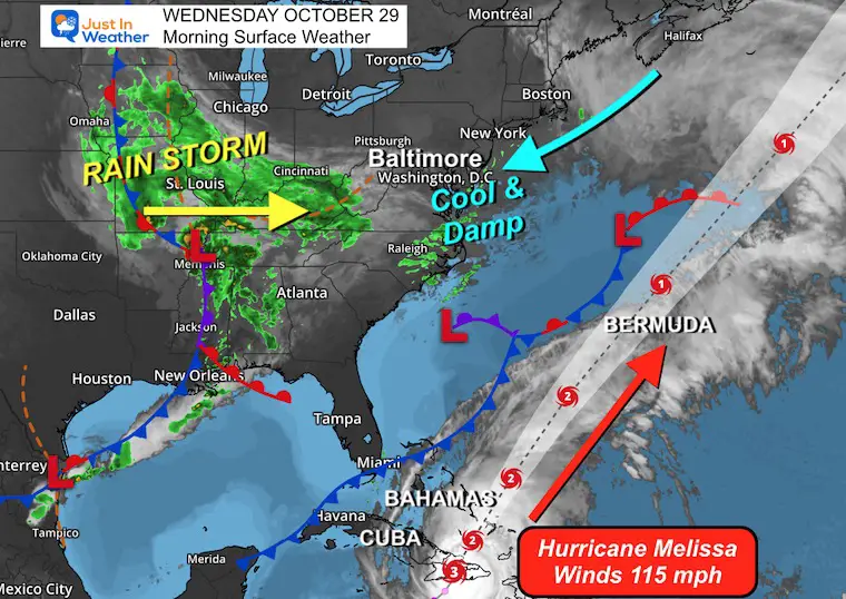
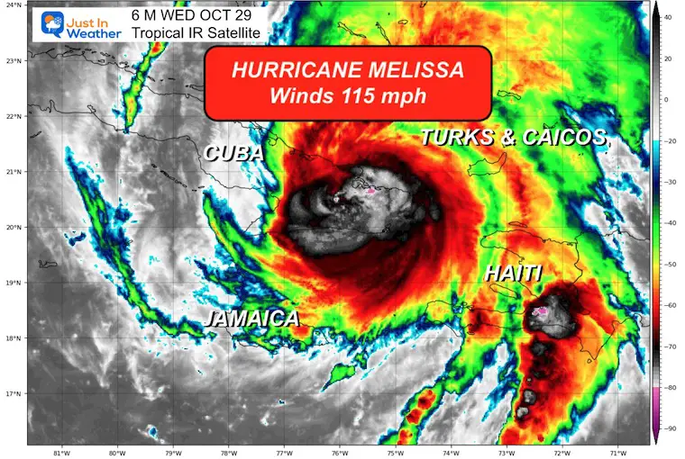
Two areas to focus on today: Hurricane Melissa is crossing Eastern Cuba as a Category 3 hurricane with 115 mph winds. We will take a brief look back and track forward.
This will miss the US, but we have our own storm already setting up dampness in the Mid-Atlantic with increasing wind and rain tonight and Thursday Morning.
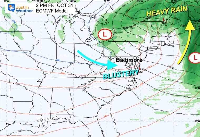
Halloween will be blustery and dry, setting up the cool pattern to remain into next week.
Reminder: Daylight Saving Time ENDS this weekend, so we will set our clocks back 1 hour Saturday Night.
Surface Weather
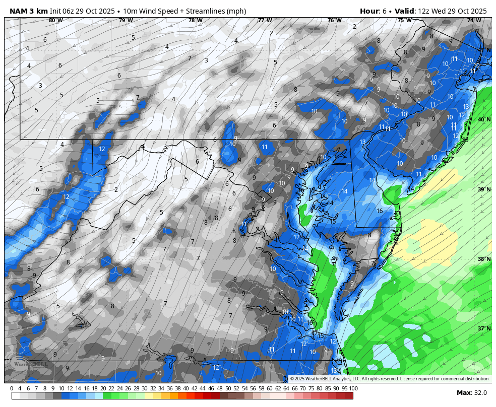
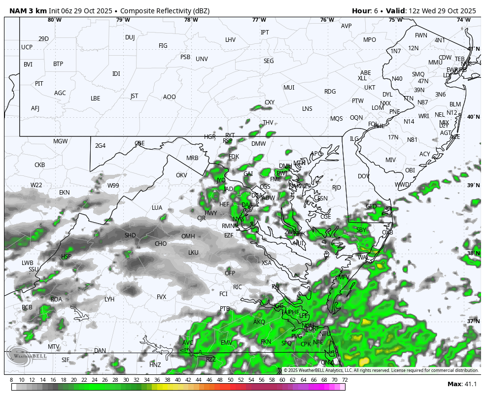
Two different storms, one being the rainmaker in the US. We will focus on that for our local rain on the way. The drizzle and showers this morning will be traded for heavier rain tonight.
Hurricane Melissa has 115 mph winds as it crosses Cuba and heads towards the Bahamas and Turks and Caicos.
Brief Storm Overview
Local Focus will be below
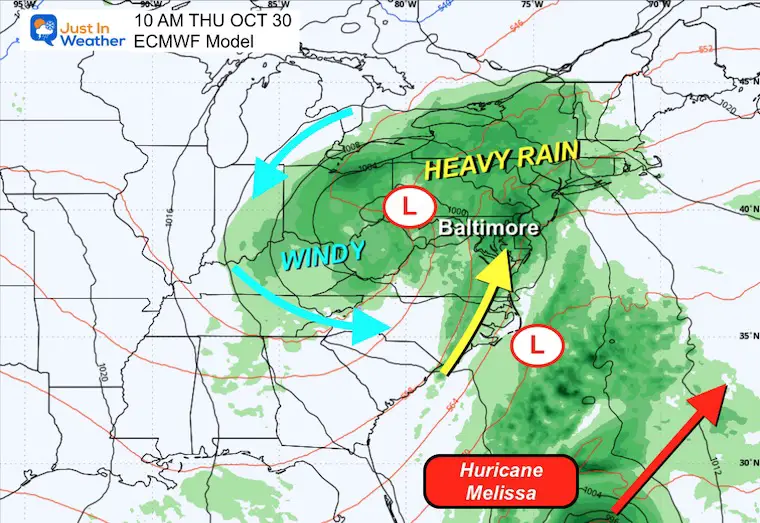
Storm Forecast: Wednesday Afternoon to Friday Afternoon
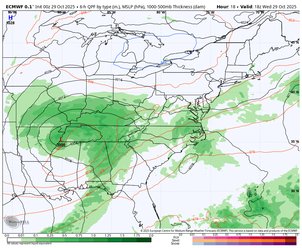
This European Model picks up the light rain today and builds in the heavier rain tonight into Thursday morning.
A second Coastal Low may develop and enhance the rain into New England while pulling the storm away quicker. This is NOT Melissa…
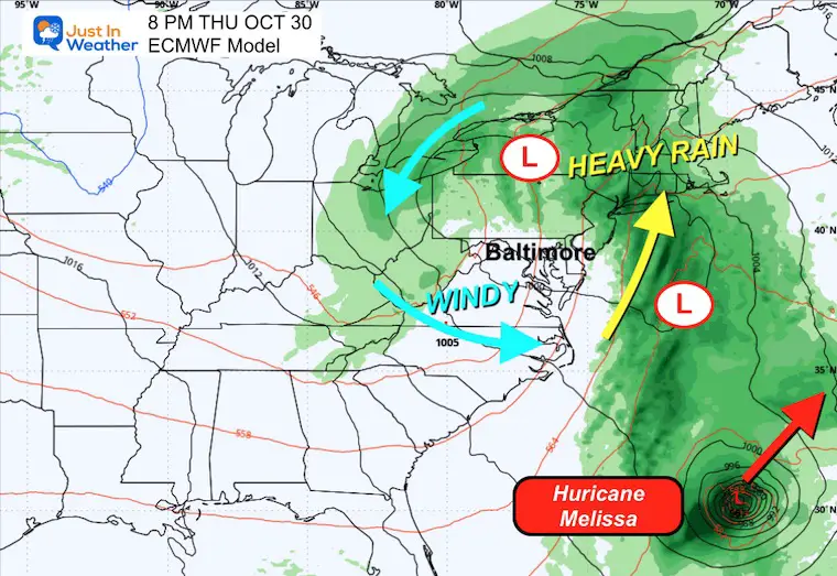
Thursday night, the rain will be focused in the Great Lakes and Northeast, followed by blustery winds that dry us out on Friday.
The hurricane can be seen on the lower right part of this view, moving well off the East Coast.
Snapshots
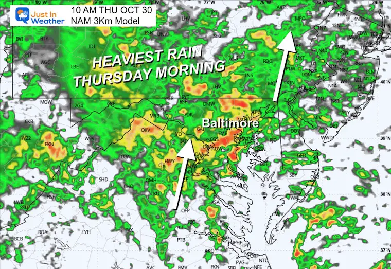
Thursday Morning
The heaviest rain will be earlier in the day through lunchtime.
Thursday Night
Rainfall will shift to New England as we get into the dry slot of this larger complex. Hurricane Melissa is seen well off the US coast and moving away from the mainland.
Halloween Friday
The storm moves away, and we get blustery winds that will be cooler and dry.
Rain may still fall over our high mountains well inland.
TROPICAL FOCUS: HURRICANE MELISSA
Still a Category 3 with 115 mph winds. This remains a compact storm as hurricane-force winds reach only 30 miles from the center. Tropical Storm force winds reach 185 miles away.
Forward speed is to the Northeast at 12 mph.
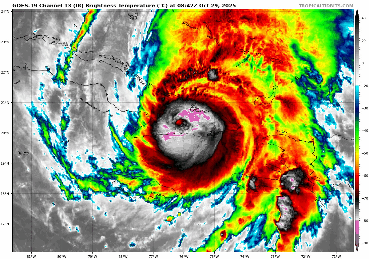
National Hurricane Center Report: Monday Morning
- LOCATION…20.3N 76.1W
- ABOUT 60 MI…95 KM W OF GUANTANAMO CUBA
- ABOUT 230 MI…370 KM S OF THE CENTRAL BAHAMAS
- MAXIMUM SUSTAINED WINDS…115 MPH…185 KM/H
- PRESENT MOVEMENT…NE OR 35 DEGREES AT 12 MPH…19 KM/H
- MINIMUM CENTRAL PRESSURE…960 MB…28.35 INCHES
Satellite Loop
National Hurricane Center Forecast Track
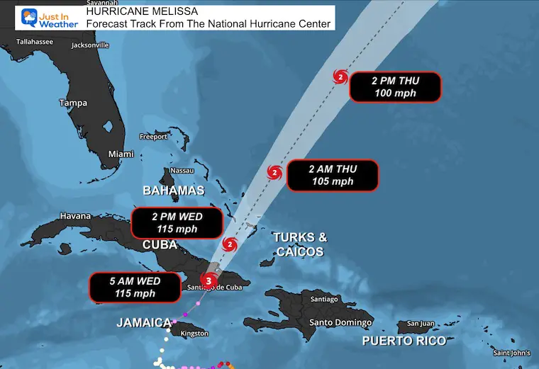
SUMMARY OF WATCHES AND WARNINGS IN EFFECT:
A Hurricane Warning is in effect for…
- Cuban provinces of Granma, Santiago de Cuba, Guantanamo, Holguin, and Las Tunas
- Southeastern and Central Bahamas
A Hurricane Watch is in effect for…
A Tropical Storm Warning is in effect for…
- Jamaica
- Haiti
- Cuban province of Camaguey
- Turks and Caicos Islands
CLOSE UP RECAP ON JAMAICA
Landfall Tuesday
This was the strongest at landfall in the Atlantic Basin
Video: Satellite Loop Crossing Jamaica
LOCAL WEATHER
Live Radar Widget
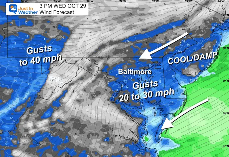
Wind Forecast 8 AM to 8 PM
Afternoon Wind Forecast
Increase in gusts that may reach 20 to 30 mph FROM the Northeast.
Rain Forecast 8 AM to 8 PM
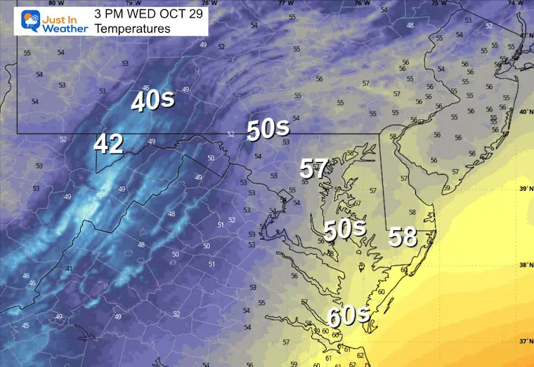
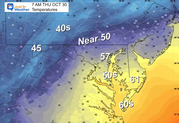
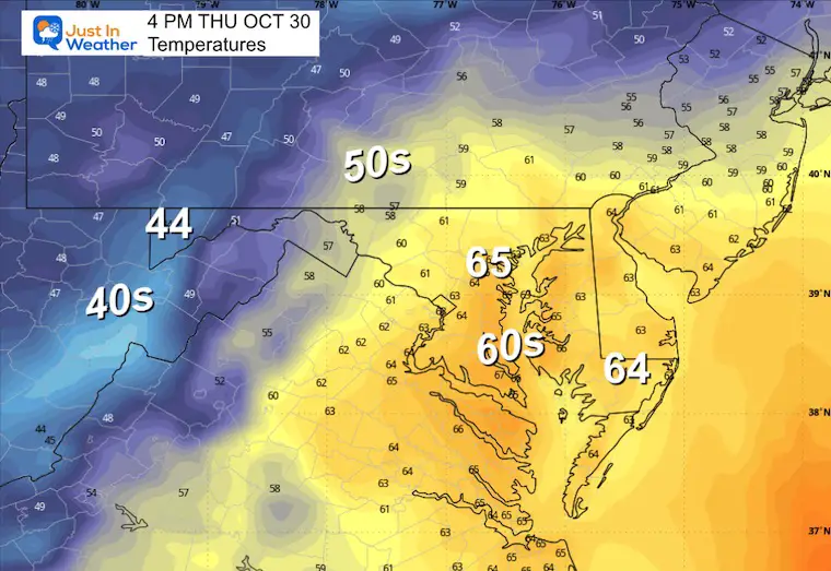
Afternoon Temperatures
Rain Forecast Tonight
6 PM Wed to 6 AM Thu
Rain increases overnight, and it will most likely be a very soggy morning.
CLIMATE DATA: Baltimore
Yesterday: Low 45F; High 57F
Precipitation: Trace
TODAY October 29
Sunrise at 7:31 AM
Sunset at 6:09 PM
Normal Low in Baltimore: 42ºF
Record 26ºF in 2001
Normal High in Baltimore: 64ºF
Record 82ºF 1945; 1946
Rainfall Deficit at BWI
- Ending 2024 = -8.00”
- Since Jan 1 = 6.80”
- We are STILL DOWN -14.80” INCLUDING LAST YEAR
Subscribe for eMail Alerts
Drought Monitor Update
The need for rain has been highlighted and may be underrepresented in some spots.
We need rain.
THURSDAY
Morning Temperatures
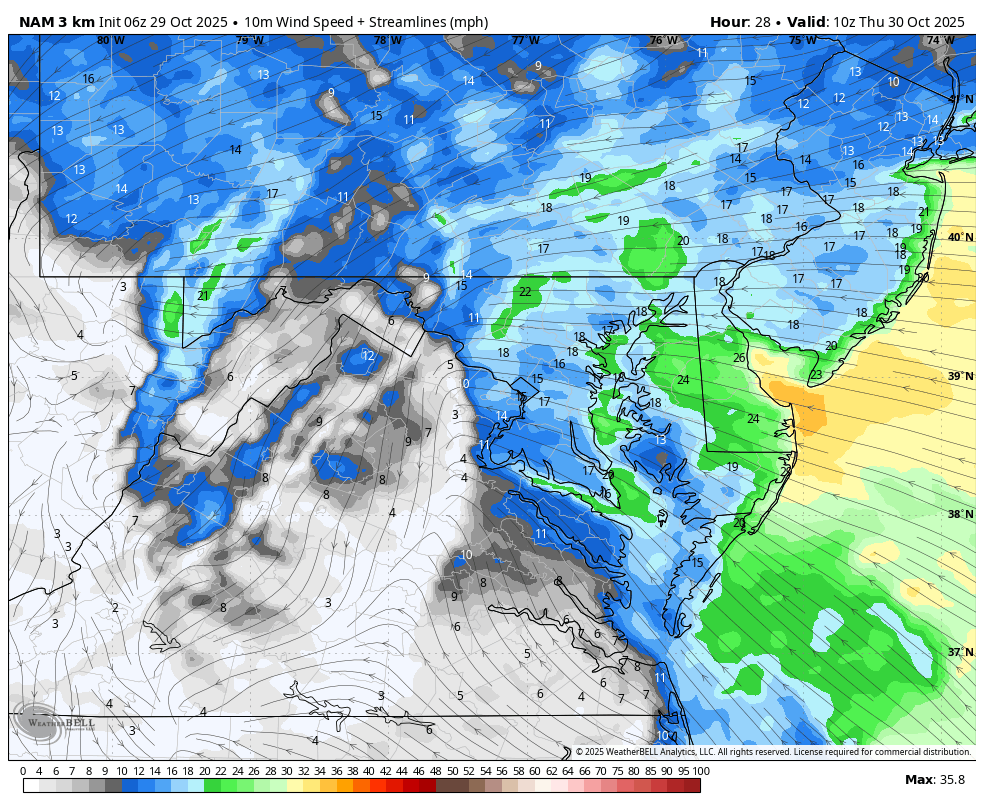
Wind Forecast 6 AM to 6 PM
Gusts to 30 mph.
Rain Forecast 6 AM to 6 PM
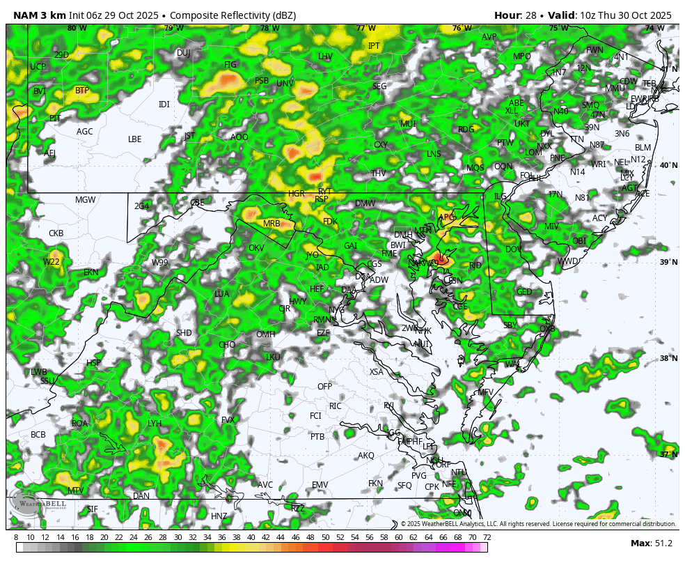
Mid Morning Rain Forecast
The heaviest rain will pass through before noon.
Afternoon Temperatures
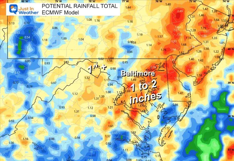
Rainfall Potential
ECMWF Model: Between 1 and 2 inches appears to be the best bet for our region.
Slightly less rain along the coast.
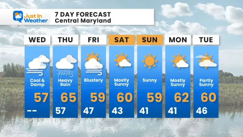
7 Day Forecast
- Today: Cool and Damp; Increasing Wind
- Thursday: Rain heaviest in the morning
- Halloween: Blustery
- Weekend: Dry
Subscribe for eMail Alerts
Average First Frost

La Niña Advisory
This was issued October 9, as expected: A weak and short-lived event to start winter may play a different role this winter

4 SUPERMOONS In A ROW

In Case You Missed It
Woolly Bear Caterpillar Winter Folklore
These are NOT all the same caterpillar!

Winter Outlook From 2 Farmers’ Almanacs

STEM Assemblies/In School Fields Trips Are Back
Click to see more and ‘Book’ a visit to your school

THANK YOU:
Baltimore Sun Magazine Readers’ Choice Best Of Baltimore

Maryland Trek 12 Day 7 Completed Sat August 9
UPDATED: We raised OVER $166,000 for Just In Power Kids – AND Still Collecting More
The annual event: Hiking and biking 329 miles in 7 days between The Summit of Wisp to Ocean City.
Each day, we honor a kid and their family’s cancer journey.
Fundraising is for Just In Power Kids: Funding Free Holistic Programs. I never have and never will take a penny. It is all for our nonprofit to operate.
Click here or the image to donate:

RESTATING MY MESSAGE ABOUT DYSLEXIA
I am aware there are some spelling and grammar typos and occasional other glitches. I take responsibility for my mistakes and even the computer glitches I may miss. I have made a few public statements over the years, but if you are new here, you may have missed it: I have dyslexia and found out during my second year at Cornell University. It didn’t stop me from getting my meteorology degree and being the first to get the AMS CBM in the Baltimore/Washington region. One of my professors told me that I had made it that far without knowing and to not let it be a crutch going forward. That was Mark Wysocki, and he was absolutely correct! I do miss my mistakes in my own proofreading. The autocorrect spell check on my computer sometimes does an injustice to make it worse. I can also make mistakes in forecasting. No one is perfect at predicting the future. All of the maps and information are accurate. The ‘wordy’ stuff can get sticky. There has been no editor who can check my work while writing and to have it ready to send out in a newsworthy timeline. Barbara Werner is a member of the web team that helps me maintain this site. She has taken it upon herself to edit typos when she is available. That could be AFTER you read this. I accept this and perhaps proves what you read is really from me… It’s part of my charm. #FITF
Please share your thoughts and best weather pics/videos, or just keep in touch via social media.


