Saturday, October 25 2025
This late-season tropical activity in the Caribbean may be one for the record books. Hurricane Melissa was upgraded to a Category 1 hurricane this afternoon and is expected to rapidly develop this weekend into a Major Hurricane. The energy needed to fuel this growth up to Category 4 or even 5 intensity is in the very warm water. But in addition to that, the warm water runs deep! So the slow movement will not upwell cooler water to the surface, allowing for maximum growth.
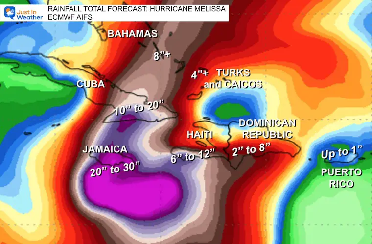
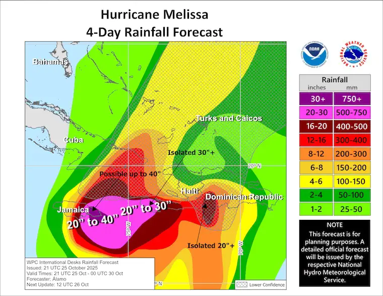
The slow movement to nearly a crawl this weekend will allow for long-duration heavy rain, which will be enhanced by the mountains on the island of Jamaica. Computer Model guidance and the National Hurricane Center forecast suggest 20 to 30 inches of rain may fall over Eastern Jamaica, with up to 40 inches in the high mountains that top over 7,000 feet. Flooding rain in Eastern Cuba will range from 10 to 20 inches, while Haiti will get less rain farther away from the track, but still enough for flooding.
A pull to the north and then rapid acceleration into the Central Atlantic will take place on Tuesday. This will track well East of the US mainland and pass close to the island of Bermuda later in the week.
To help emphasize the danger, this is part of the latest update from the National Hurricane Center:
MELISSA BECOMES A HURRICANE AND IS EXPECTED TO RAPIDLY INTENSIFY INTO A MAJOR HURRICANE BY THE END OF THE WEEKEND…
LIFE-THREATENING AND CATASTROPHIC FLASH FLOODING AND LANDSLIDES EXPECTED IN PORTIONS OF SOUTHERN HISPANIOLA AND JAMAICA INTO EARLY NEXT WEEK…
EDITED FOR NEWER REPORT
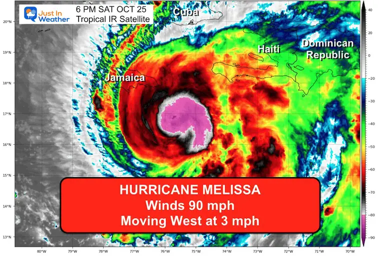
6 PM Update From the National Hurricane Center
- LOCATION…16.6N 75.5W
- ABOUT 130 MI…210 KM SE OF KINGSTON JAMAICA
- ABOUT 250 MI…405 KM WSW OF PORT AU PRINCE HAITI
- MAXIMUM SUSTAINED WINDS…90 MPH…150 KM/H
- PRESENT MOVEMENT…W OR 275 DEGREES AT 3 MPH…6 KM/H
- MINIMUM CENTRAL PRESSURE…974 MB…28.77 INCHES
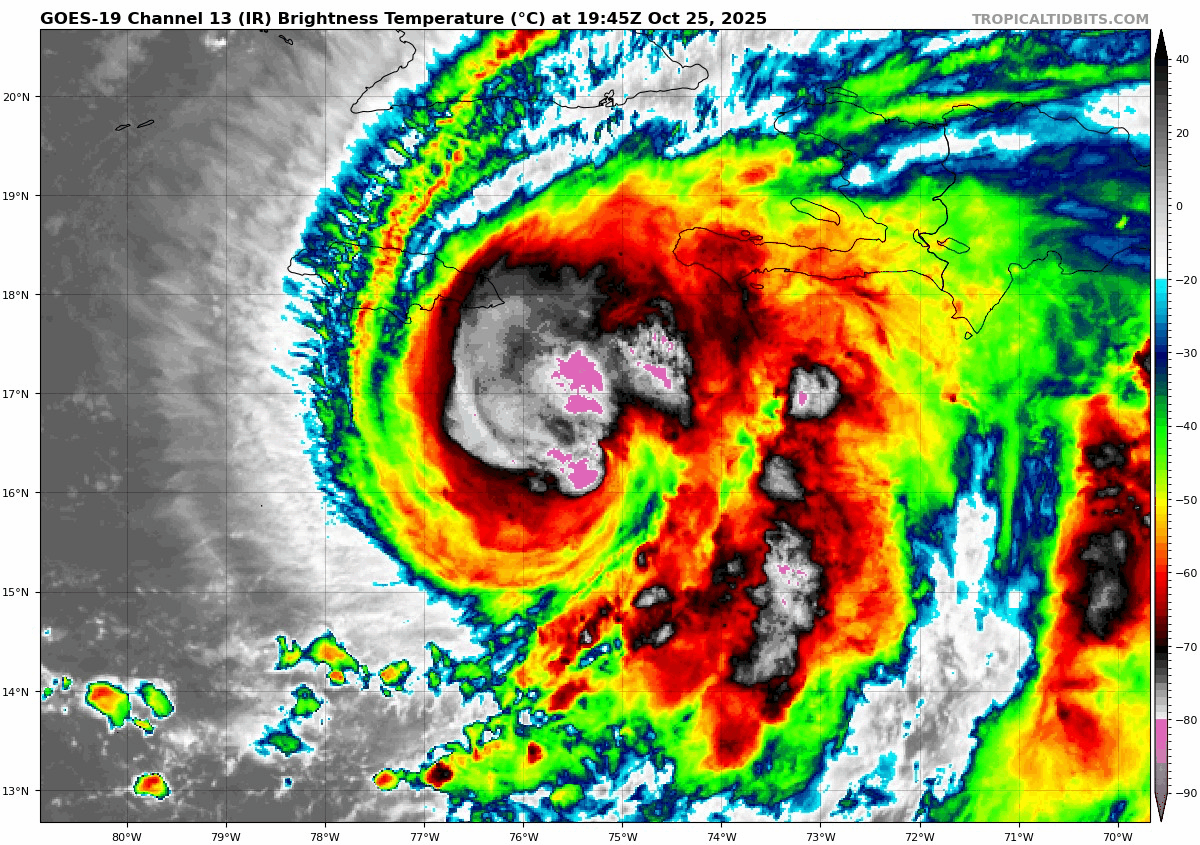
Tropical Satellite Loop
The structure looks much better organized as convection is wrapping around the center of the low-pressure. Now that there is an enclosed eye wall structure, rapid development will allow this to reach major hurricane intensity this weekend.
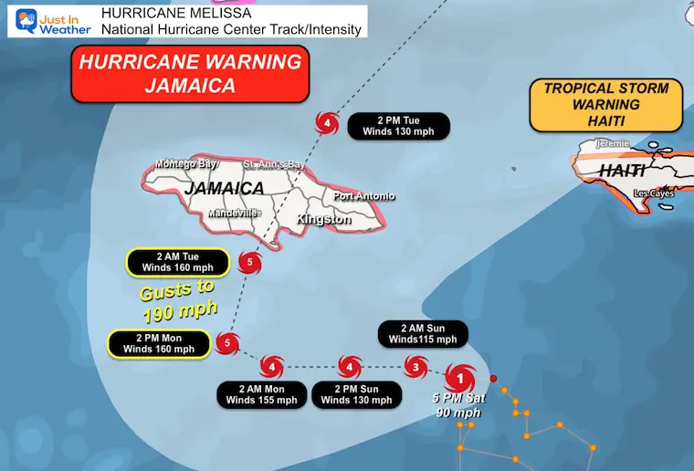
Close Track And Alerts
A Hurricane Warning is in effect for…
A Hurricane Watch is in effect for…
- Southwestern peninsula of Haiti, from the border with the Dominican Republic to Port-Au-Prince
A Tropical Storm Warning in effect for…
- Southwestern peninsula of Haiti from the border with the Dominican Republic to Port-Au-Prince
Rainfall Forecast: ECMWF AIFS
Expectations for 20 to 30 inches across the Eastern side of Jamaica.
With the high mountains over 7,000 Ft, local rainfall may top 40 inches.
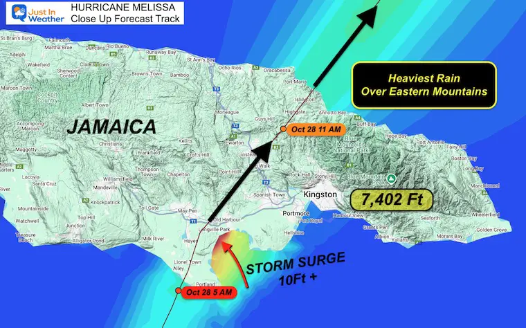
Jamaica Island Track
This topographical view shows the track on Tuesday.
The stronger side of the storm is on the right side with forward movement. This places Kingston on the right eye wall AND Blue Mountain. That peak is 7,402 Ft high, one of the highest in the Caribbean. Those mountains will inevitably enhance the rainfall, which could double forecasts. Yes, 40” of rainfall is possible.
This will lead to devastating flooding and mudslides.
Forecast Rainfall: National Hurricane Center Projections
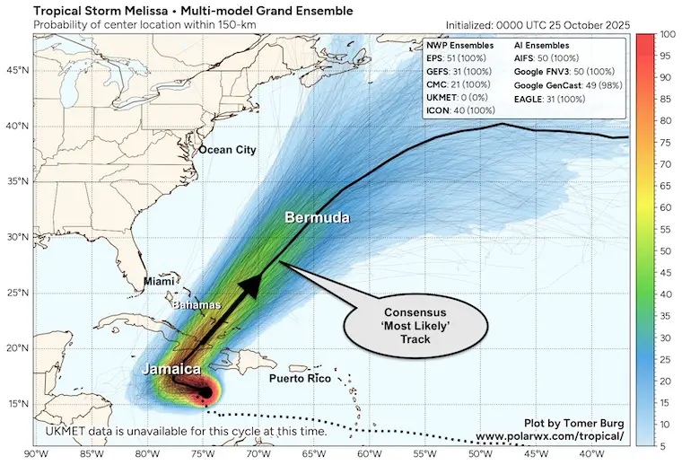
Forecast Track: Computer Model Grand Ensembles
This consists of 360 different run solutions as noted. The colors and density correlate to the ‘cone’ you may see from the OFFICIAL National Hurricane Center Track Map.
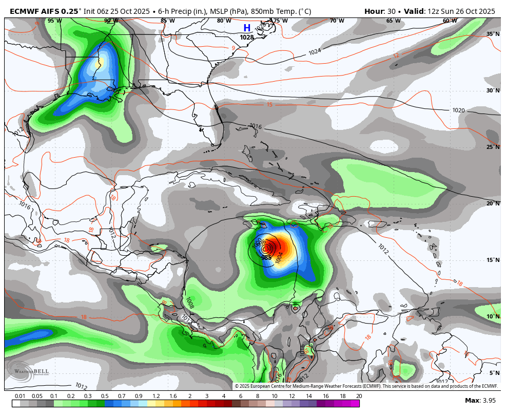
Wider View Forecast: ECMWF AIFS
Sunday October 26 to Saturday, November 1
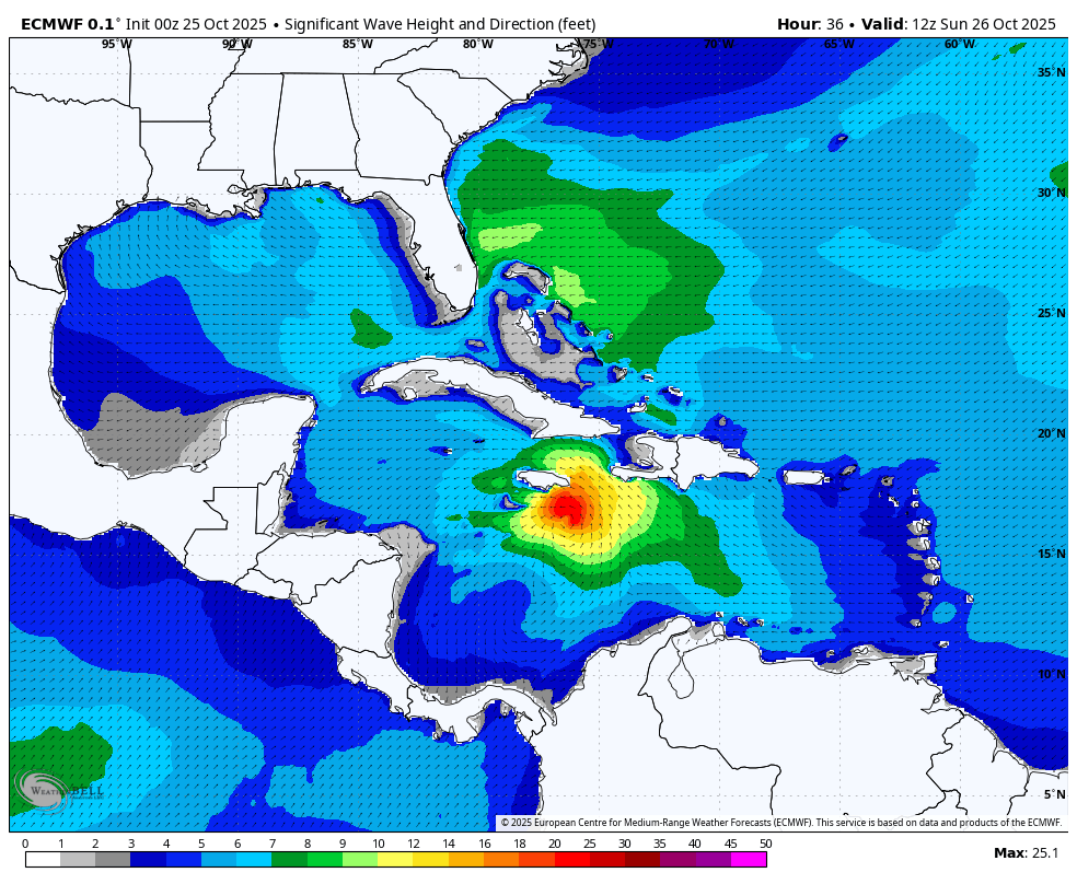
Wave Forecast
The waves associated with Hurricane Melissa will be localized. While they may top 60 Ft and the storm surge will add to the devastation in Jamaica, they will not impact the Eastern US.
The waves off the East Coast are from the Jet Stream that will help kick the hurricane to the north and into the Central Atlantic.
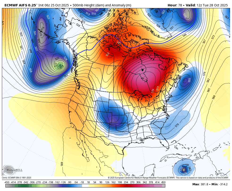
North American Jet Stream
The Polar Jet will be diving into the US, and in this view, we can see how it will interact with Hurricane Melissa to kick it out of the Caribbean.
This is also validation that this will NOT be an East Coast event.
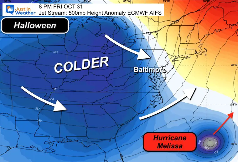
Halloween Day Snapshot
With the advance of a Canadian Air Mass towards the East Coast, this will protect the US mainland and help drive Hurricane Melissa into the Central Atlantic.
Subscribe for eMail Alerts
EXPLORE MORE
La Niña Advisory
This was issued October 9, as expected: A weak and short-lived event to start winter may play a different role this winter

Average First Frost

4 SUPERMOONS In A ROW

In Case You Missed It
Woolly Bear Caterpillar Winter Folklore
These are NOT all the same caterpillar!

Winter Outlook From 2 Farmers’ Almanacs

STEM Assemblies/In School Fields Trips Are Back
Click to see more and ‘Book’ a visit to your school

THANK YOU:
Baltimore Sun Magazine Readers’ Choice Best Of Baltimore

Maryland Trek 12 Day 7 Completed Sat August 9
UPDATED: We raised OVER $166,000 for Just In Power Kids – AND Still Collecting More
The annual event: Hiking and biking 329 miles in 7 days between The Summit of Wisp to Ocean City.
Each day, we honor a kid and their family’s cancer journey.
Fundraising is for Just In Power Kids: Funding Free Holistic Programs. I never have and never will take a penny. It is all for our nonprofit to operate.
Click here or the image to donate:

RESTATING MY MESSAGE ABOUT DYSLEXIA
I am aware there are some spelling and grammar typos and occasional other glitches. I take responsibility for my mistakes and even the computer glitches I may miss. I have made a few public statements over the years, but if you are new here, you may have missed it: I have dyslexia and found out during my second year at Cornell University. It didn’t stop me from getting my meteorology degree and being the first to get the AMS CBM in the Baltimore/Washington region. One of my professors told me that I had made it that far without knowing and to not let it be a crutch going forward. That was Mark Wysocki, and he was absolutely correct! I do miss my mistakes in my own proofreading. The autocorrect spell check on my computer sometimes does an injustice to make it worse. I can also make mistakes in forecasting. No one is perfect at predicting the future. All of the maps and information are accurate. The ‘wordy’ stuff can get sticky. There has been no editor who can check my work while writing and to have it ready to send out in a newsworthy timeline. Barbara Werner is a member of the web team that helps me maintain this site. She has taken it upon herself to edit typos when she is available. That could be AFTER you read this. I accept this and perhaps proves what you read is really from me… It’s part of my charm. #FITF
Please share your thoughts and best weather pics/videos, or just keep in touch via social media.


