Monday October 20 2025
After reaching the mid-70s yesterday, the rain did arrive during the evening and overnight to bring in cooler air.
The rain totals did provide a needed soaking and lived up to expectations in many areas west of the cities. You may run into more rain this morning if you are traveling west and north.
If you are still interested in the tropics, the season may have a new storm on a southern track through the Caribbean. There is a split in where it may go, but no interest to our region.
Let’s take a look…
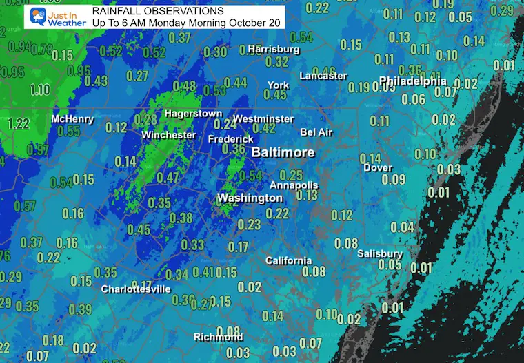
Rainfall Total As Of 6 AM
Over 0.25” fell west and north of Baltimore. I will wait until the final rain totals are posted to compare them to the model forecasts I’ve been showing over the last 5 days.
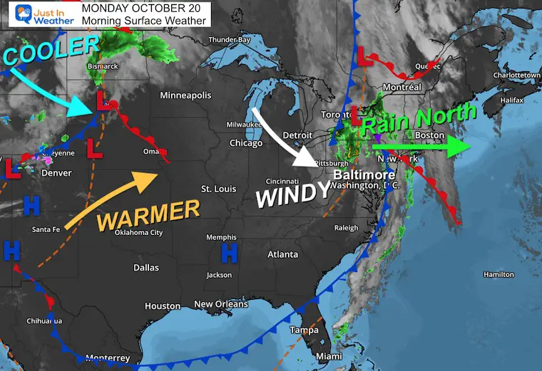
Surface Weather
A very active weather pattern will be changing quickly. Locally, the rain has moved out, but you might run into rain if you travel west or north this morning
A gusty wind will develop as cooler air spills into the Mid-Atlantic.
A warm-up in the middle of the nation will reach us briefly tomorrow, followed by more cool winds mid-week.
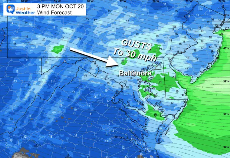
Wind Forecast 8 AM to 8 PM
Gusty winds from the Northwest will bring in cooler air.
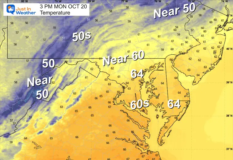
Afternoon Snapshot
Gusts over 30 mph earlier in the day. Still 20 to 30 mph gusts this afternoon.
Afternoon Temperatures
CLIMATE DATA: Baltimore
Yesterday: Low 48F; High 76F
Precipitation: 0.21” (up to midnight)
TODAY October 20
Sunrise at 7:22 AM
Sunset at 6:20 PM
Normal Low in Baltimore: 45ºF
Record 28ºF in 1972; 1981; 1992
Normal High in Baltimore: 67ºF
Record 87ºF 1969
Rainfall Deficit at BWI
- Ending 2024 = -8.00”
- Since Jan 1 = 5.85”
- We are STILL DOWN -13.85” INCLUDING LAST YEAR
Subscribe for eMail Alerts
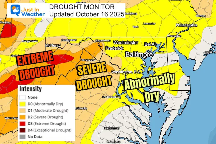
Drought Update: Report on Thursday
Extreme Drought in the Mountains
Abnormally dry in metro areas, but it seems worse than that.
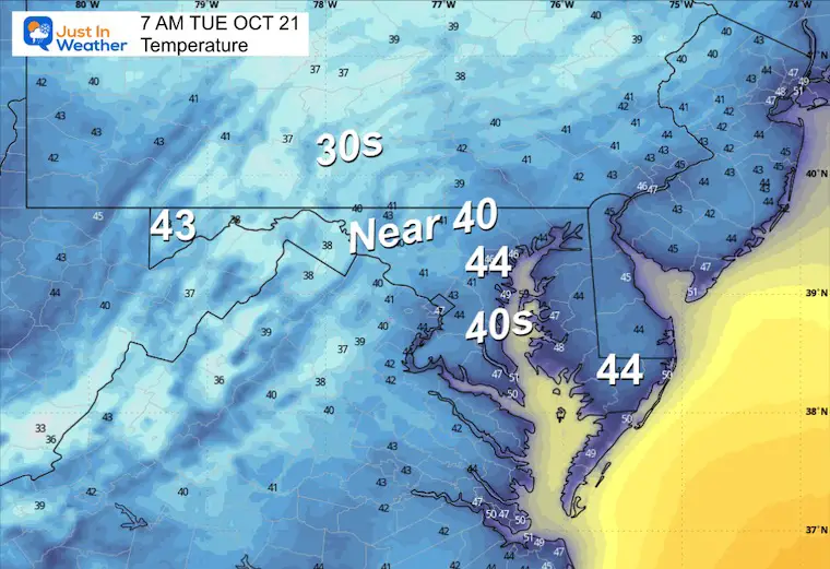
TUESDAY
Morning Temperatures
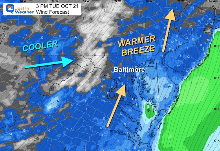
Afternoon Wind Snapshot
Gusts will push warmer air ahead of the next cold front.
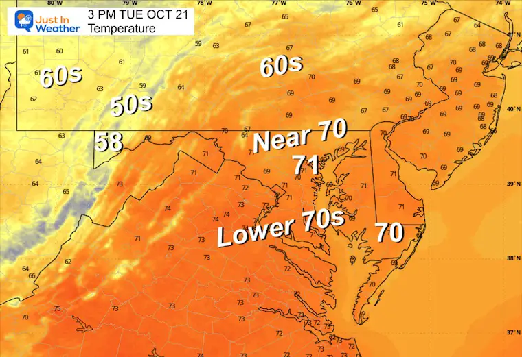
Afternoon Temperatures
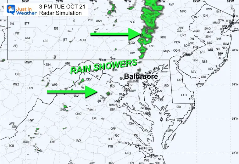
Afternoon Radar Simulation
Rain showers develop for a few hours.
Animation Noon to Midnight
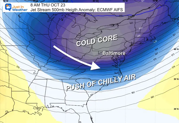
Looking Ahead: Jet Stream Through The Weekend
A push of chilly air will be followed by a ridge of High Pressure to keep us dry into the weekend.
Thursday Morning
The push of chilly air will allow another frost in parts of the Mid-Atlantic.
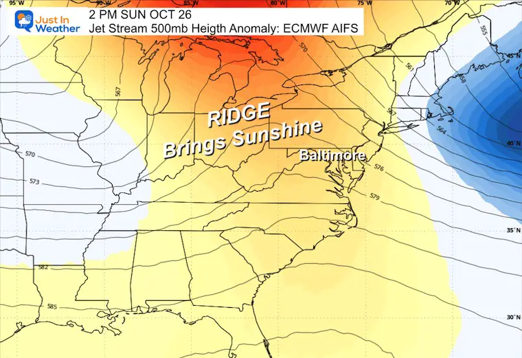
Sunday Afternoon
This is not a warm-up, just a ridge of High Pressure to keep us dry through the weekend.
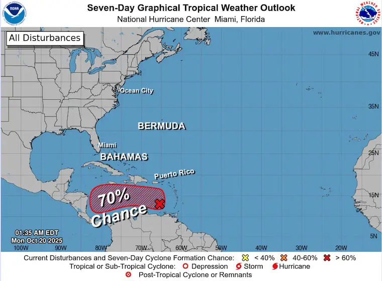
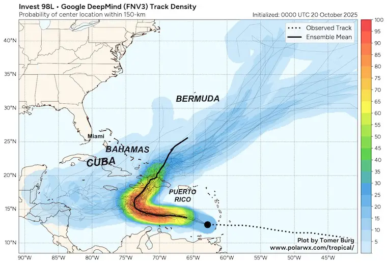
Tropical Outlook
The next storm potential is up to 70% over the next week.
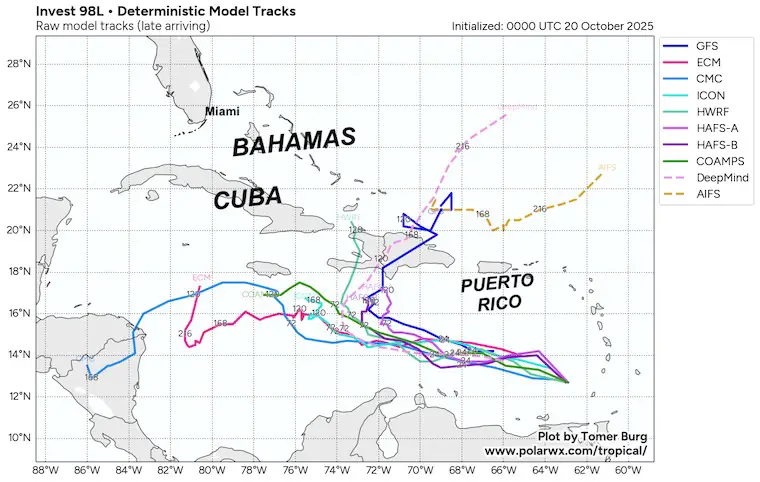
This will be a southern track Caribbean system, but the computer modeling is split on whether it stays south or gets picked up by a trough and pulled north.
Computer Model Guidance
Google DeepMind Forecast
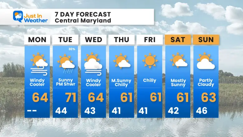
7 Day Forecast
- Today: Windy and Cooler
- Tomorrow: Brief Warm Up With Afternoon Showers
- More Chilly Air To Last The Rest Of The Week
Subscribe for eMail Alerts
Average First Frost

La Niña Advisory
This was issued October 9, as expected: A weak and short-lived event to start winter may play a different role this winter

4 SUPERMOONS In A ROW

In Case You Missed It
Woolly Bear Caterpillar Winter Folklore
These are NOT all the same caterpillar!

Winter Outlook From 2 Farmers’ Almanacs

STEM Assemblies/In School Fields Trips Are Back
Click to see more and ‘Book’ a visit to your school

THANK YOU:
Baltimore Sun Magazine Readers’ Choice Best Of Baltimore

Maryland Trek 12 Day 7 Completed Sat August 9
UPDATED: We raised OVER $166,000 for Just In Power Kids – AND Still Collecting More
The annual event: Hiking and biking 329 miles in 7 days between The Summit of Wisp to Ocean City.
Each day, we honor a kid and their family’s cancer journey.
Fundraising is for Just In Power Kids: Funding Free Holistic Programs. I never have and never will take a penny. It is all for our nonprofit to operate.
Click here or the image to donate:

RESTATING MY MESSAGE ABOUT DYSLEXIA
I am aware there are some spelling and grammar typos and occasional other glitches. I take responsibility for my mistakes and even the computer glitches I may miss. I have made a few public statements over the years, but if you are new here, you may have missed it: I have dyslexia and found out during my second year at Cornell University. It didn’t stop me from getting my meteorology degree and being the first to get the AMS CBM in the Baltimore/Washington region. One of my professors told me that I had made it that far without knowing and to not let it be a crutch going forward. That was Mark Wysocki, and he was absolutely correct! I do miss my mistakes in my own proofreading. The autocorrect spell check on my computer sometimes does an injustice to make it worse. I can also make mistakes in forecasting. No one is perfect at predicting the future. All of the maps and information are accurate. The ‘wordy’ stuff can get sticky. There has been no editor who can check my work while writing and to have it ready to send out in a newsworthy timeline. Barbara Werner is a member of the web team that helps me maintain this site. She has taken it upon herself to edit typos when she is available. That could be AFTER you read this. I accept this and perhaps proves what you read is really from me… It’s part of my charm. #FITF
Please share your thoughts and best weather pics/videos, or just keep in touch via social media.


