Thursday Night Update October 9 2025
The next coastal storm is going to be another fascinating weather event to watch develop, and I am grateful this is not winter. If so, then calling snow totals would be nearly impossible.
What we are about to witness is the interaction of two short waves in the jet stream coming together to form a larger storm that may get stuck for a few days.
On the surface, the recent double hurricanes brought the Fujiwhara Effect into pop culture. That interaction of two low-pressure centers can be on display in various weather scales.
In this case, the jet stream focus will reflect in a coastal low-pressure system that is expected to nearly stall or loop around the Mid Atlantic.
THE TRUTH
- We have a good idea that this will happen. The physics of the atmosphere all point to that.
- We DO NOT have a handle on the specifics of how this will loop and where. That makes the call for how much rainfall a big challenge.
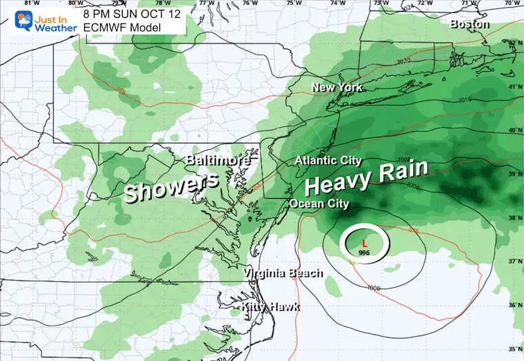
- In the meantime, we know rain showers will develop on Saturday and expand on Sunday.
- The main event will develop later Sunday into Monday, then on Tuesday is expected to move off the coast.
- The spin up may resemble a Subtropical storm, and I am not sure if it will get a name. If it does, then next on the list is Karen, and I can see the memes forming already.
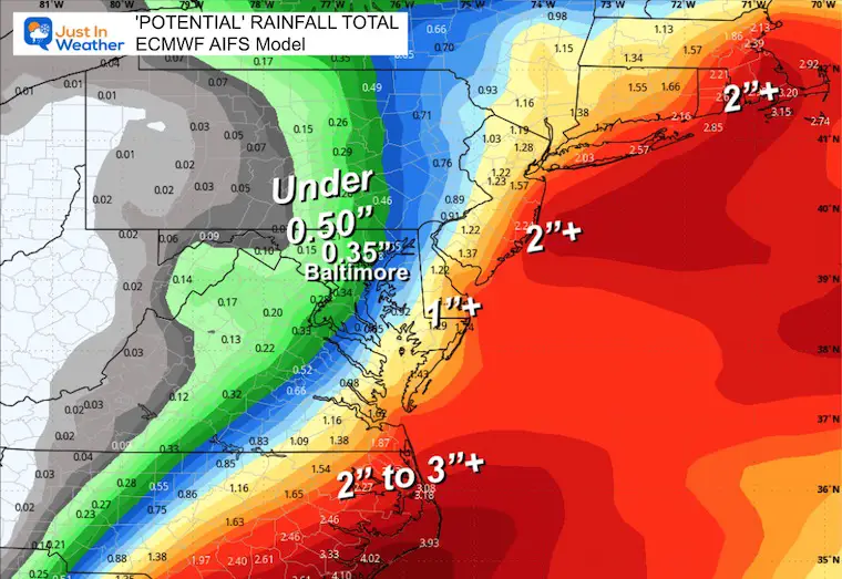
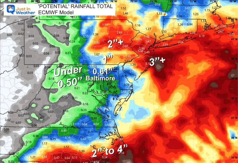
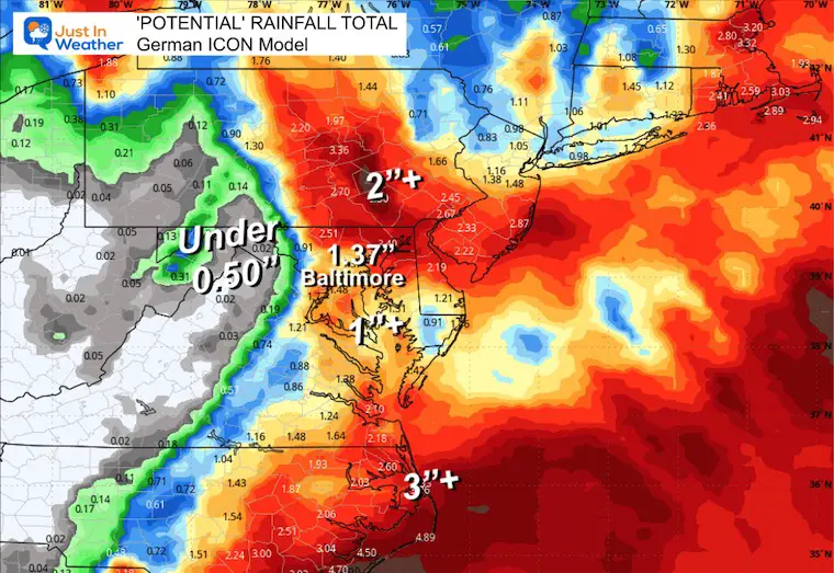
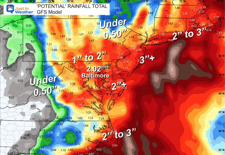
- To remain consistent, here is a look at how the European Model sees this unfolding.
- I have included rainfall totals from 5 different models to show the wide range of possible results.
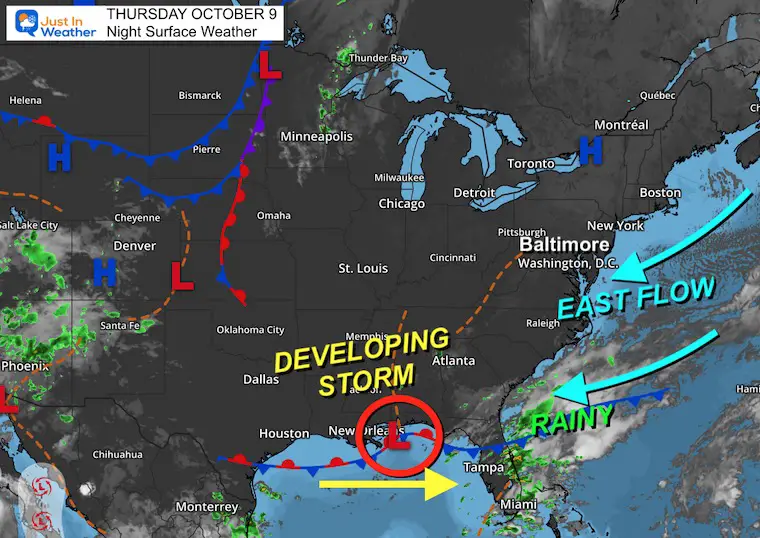
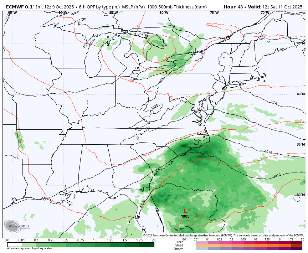
Thursday Night Set Up
The main storm is going to start with Low Pressure near New Orleans, riding along the old cold front.
Rain is falling on the Florida coast.
An onshore wind from the East is helped by High Pressure in New York.
We can add in the astronomical King Tides for enhanced beach erosion all the way up the coast already.
Jet Stream at 18,000 Ft
Here is a look at the Vorticity or spin aloft. This helps us see the ‘short wave’ I mentioned above.
The stronger one will be dropping south from Canada. The other will be associated with the Surface Low to the South.
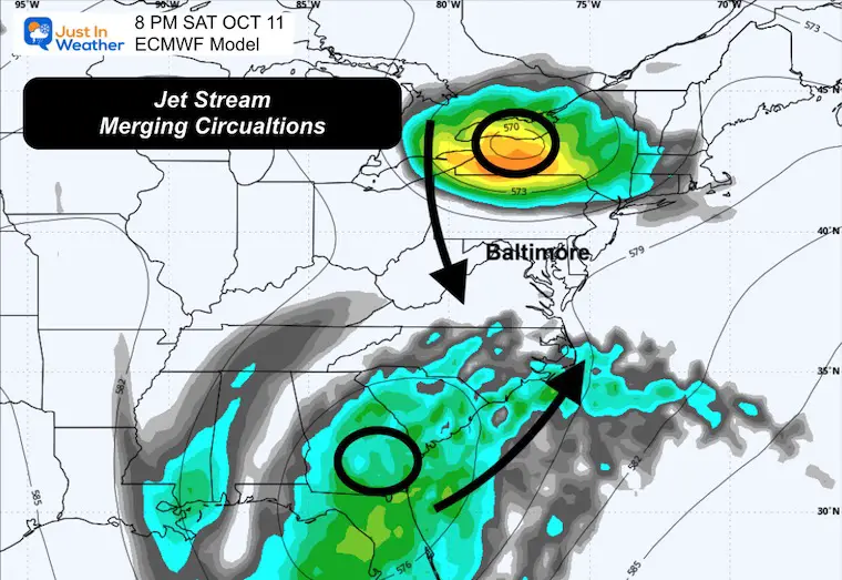
Saturday Night
We can see the two areas of focus set to approach the Mid-Atlantic. They will end up orbiting and then merging into a cut off system over the Mid-Atlantic.
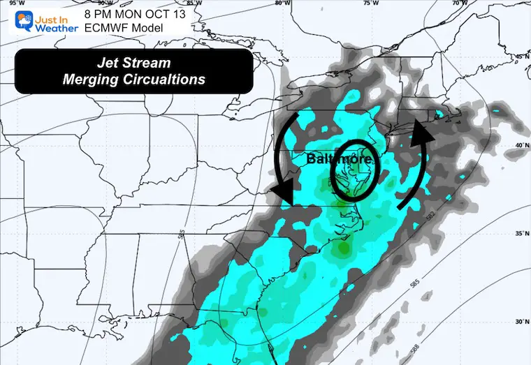
Monday Night
The Upper Level Cut Off Low will be over the Mid-Atlantic, separated from the main jet stream. This is aloft and will capture the Surface Low and pull it back in the loop.
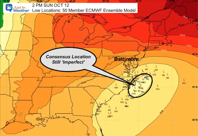
Ensemble Low-Pressure Locations
Here is the result of the 50 members of the ECMWF Model. All the scenarios are run to produce these results. We look for the consensus or region where the bulk are located to get a better handle on what to expect.
Storm Animation Saturday Morning to Tuesday Morning
This is ONE SUGGESTION of how the Low Pressure will develop and loop back towards the coast.
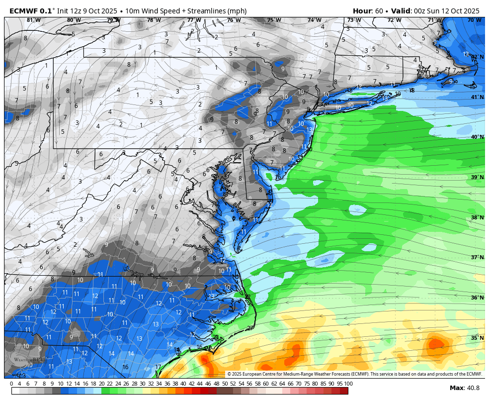
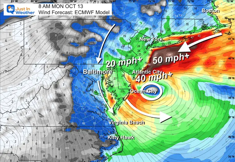
Wind Forecast Saturday Night to Tuesday Morning
This may help show with the surface circulation how the center Low Pressure gets pulled back and looped around the Mid-Atlantic.
This is NOT PERFECT, and why calling the specifics is very challenging. Where and when will it make the turn? How will it track? Where will the heavy rain set up? All those questions are still hard to pin down.
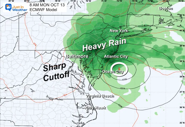
Snapshot Sunday Night
Surface Wind
Surface Pressure
Snapshot Monday Morning
Surface Wind
Surface Pressure
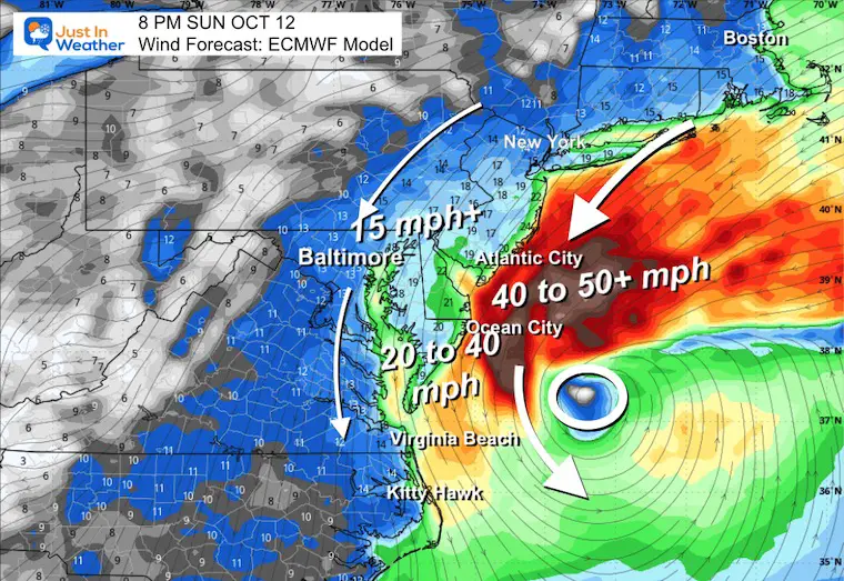
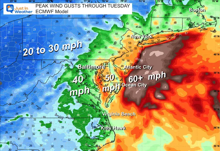
Peak Wind Gusts
This is tropical storm strength by the coast.
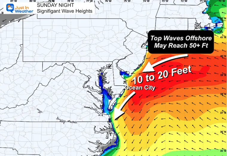
Wave Forecast
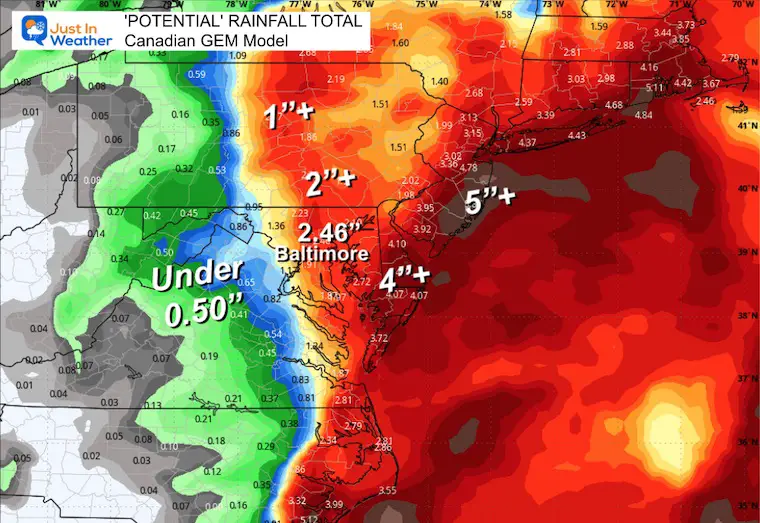
Rain Total Forecasts (5 Models)
Lowest To Highest
Note: I would lean toward the middle of what we see here, which still places the potential for 1 to 2 inches in Central Maryland.
This will be a test for the AI version of the European Model. It has been aggressive with this system and is now trending to be the lowest with rainfall.
ECMWF AI Model
ECMWF Operational Model
ICON Model
GFS Model
Canadian Model
Subscribe for eMail Alerts
In Case You Missed It

4 SUPERMOONS In A ROW

Woolly Bear Caterpillar Winter Folklore
These are NOT all the same caterpillar!

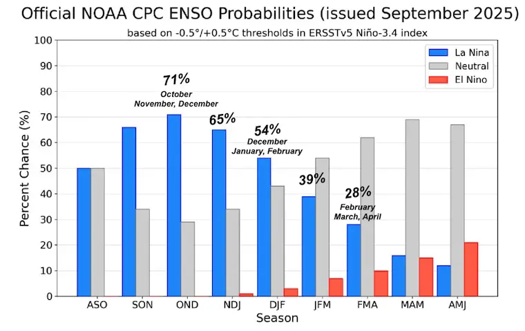
La Niña
I posted a report earlier about La Niña Watch. This is expected to be brief and trend back to neutral, which could result in an active and snowy winter.
Take A Look…
Winter Outlook From 2 Farmers Almanacs

STEM Assemblies/In School Fields Trips Are Back
Click to see more and ‘Book’ a visit to your school

THANK YOU:
Baltimore Sun Magazine Readers’ Choice Best Of Baltimore

Maryland Trek 12 Day 7 Completed Sat August 9
UPDATED: We raised OVER $166,000 for Just In Power Kids – AND Still Collecting More
The annual event: Hiking and biking 329 miles in 7 days between The Summit of Wisp to Ocean City.
Each day, we honor a kid and their family’s cancer journey.
Fundraising is for Just In Power Kids: Funding Free Holistic Programs. I never have and never will take a penny. It is all for our nonprofit to operate.
Click here or the image to donate:

RESTATING MY MESSAGE ABOUT DYSLEXIA
I am aware there are some spelling and grammar typos and occasional other glitches. I take responsibility for my mistakes and even the computer glitches I may miss. I have made a few public statements over the years, but if you are new here, you may have missed it: I have dyslexia and found out during my second year at Cornell University. It didn’t stop me from getting my meteorology degree and being the first to get the AMS CBM in the Baltimore/Washington region. One of my professors told me that I had made it that far without knowing and to not let it be a crutch going forward. That was Mark Wysocki, and he was absolutely correct! I do miss my mistakes in my own proofreading. The autocorrect spell check on my computer sometimes does an injustice to make it worse. I can also make mistakes in forecasting. No one is perfect at predicting the future. All of the maps and information are accurate. The ‘wordy’ stuff can get sticky. There has been no editor who can check my work while writing and to have it ready to send out in a newsworthy timeline. Barbara Werner is a member of the web team that helps me maintain this site. She has taken it upon herself to edit typos when she is available. That could be AFTER you read this. I accept this and perhaps proves what you read is really from me… It’s part of my charm. #FITF
Please share your thoughts and best weather pics/videos, or just keep in touch via social media.


