Saturday, September 6, 2025
We still have that late summer feel this morning, and the warm, humid air will feed into the next cold front. We have a risk for storms to turn severe with high winds and large hail.
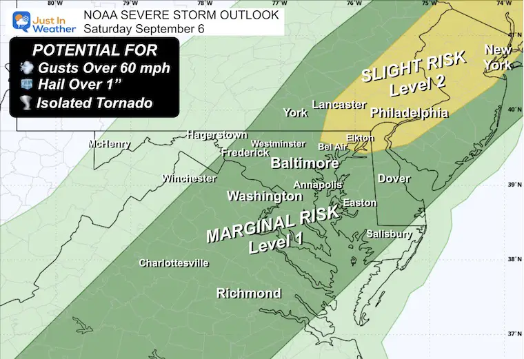
NOAA SEVERE STORM RISK
- A few storm cells may contain damaging winds, large hail, and even an isolated tornado.
- Any storm may contain dangerous lightning.
- Best TIMING will be AFTER 3 PM
- See the live radar and forecast simulation below.
The danger with lightning in any of these cells is important to time out, and I realize our standard computer models have been unreliable. The recent event was more impressive AND two hours earlier than they suggested on Thursday.
In this report, I have included the LIVE radar widget and a different experimental model to follow and see if it does a better job. The guidance is just that: GUIDANCE. It is not perfect, and I encourage you to simply pay attention for storms to erupt any time after 3 PM.
Cooler and quieter weather will follow for much of the next week.
The tropical outlook still has the potential for Gabrielle to form in the week ahead and reach the Caribbean. This has run into some shear, and the chance has been lowered a little.
FRIDAY SMOKEY SUNSET
If you saw the deep red sun setting like this yesterday, or even a pink moon rising… There was a plume of wildfire smoke that filled in across the Eastern US.
LOCAL WEATHER TODAY
LIVE RADAR WIDGET
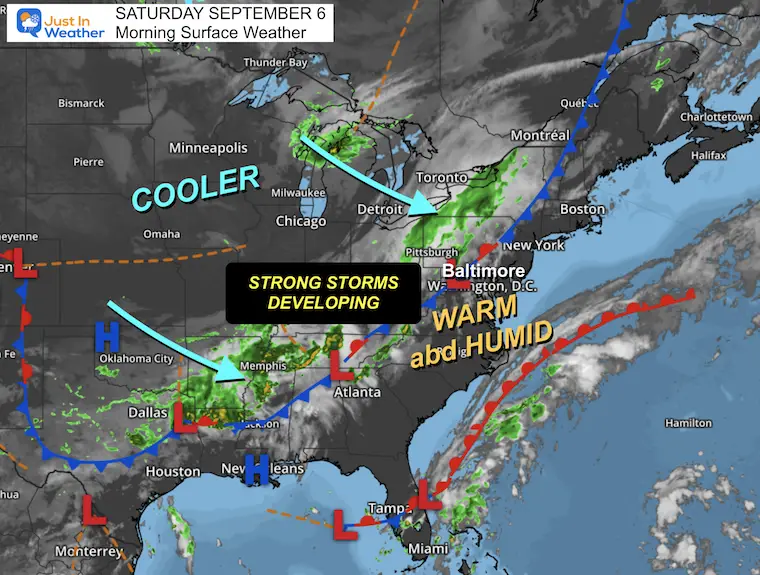
Surface Weather
A strong cold front will be passing through today. It will have a line of storms forming that could reach severe limits mid-afternoon through tonight.
Gusty winds from the Northwest will follow, bringing in the new air mass and a reinforcing push of cooler air.
This will be followed by another period of below-average temperatures.
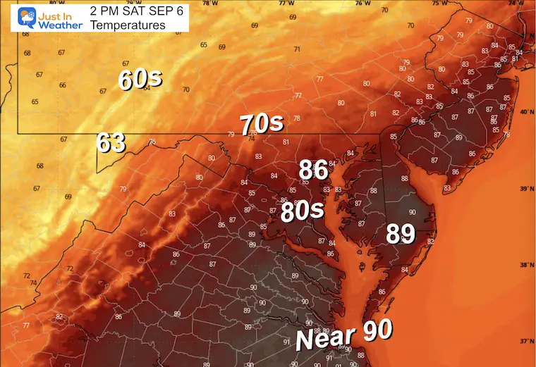
Afternoon Temperatures
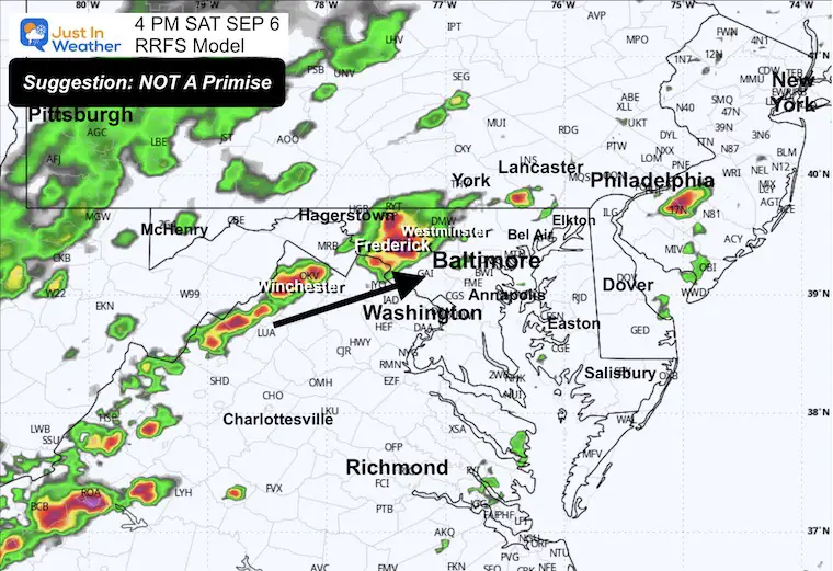
Radar Simulation Noon to Midnight
4 PM Snapshot
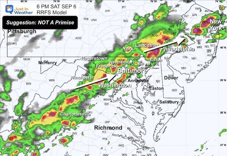
6 PM Snapshot
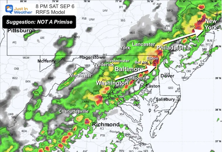
8 PM Snapshot
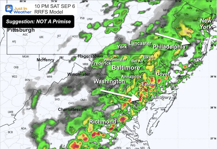
10 PM Snapshot
CLIMATE DATA: Baltimore
Yesterday: Low 63F; High 89F
Precipitation: 0.00”
TODAY September 6
Sunrise at 6:40 AM
Sunset at 7:29 PM
Normal Low in Baltimore: 62ºF
Record 46ºF in 1962
Normal High in Baltimore: 83ºF
Record 100ºF 2023
Rainfall Deficit at BWI
- Ending 2024 = -8.00”
- Since Jan 1 = 3.33”
- We are STILL DOWN -11.33” INCLUDING LAST YEAR
Subscribe for eMail Alerts
STEM Assemblies/In School Fields Trips Are Back
Click to see more and ‘Book’ a visit to your school 
Maryland Trek 12 Day 7 Completed Sat August 9
UPDATED: We raised OVER $166,000 for Just In Power Kids – AND Still Collecting More
The annual event: Hiking and biking 329 miles in 7 days between The Summit of Wisp to Ocean City.
Each day, we honor a kid and their family’s cancer journey.
Fundraising is for Just In Power Kids: Funding Free Holistic Programs. I never have and never will take a penny. It is all for our nonprofit to operate.
Click here or the image to donate:

SATURDAY
Morning Temperatures
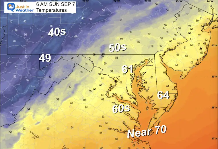
Radar Simulation 6 AM to 4 PM
Showers may linger on the Eastern Shore into midday or early afternoon. Clearing will expand from the Northwest.
Wind Forecast 6 AM to 4 PM
Winds will be gusty from the Northwest at 10 to 20 mph.
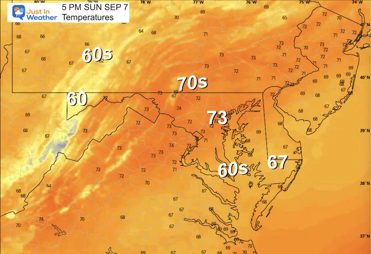
Afternoon Temperatures
LOOKING AHEAD
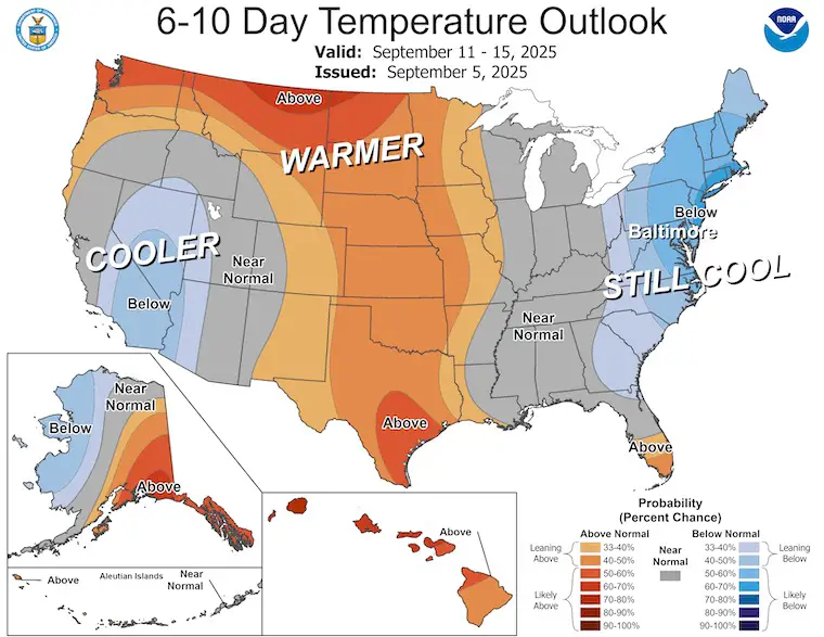
NOAA Temperature Outlook
The overall trend REMAINS Cooler than average. But this will include a few warm days.
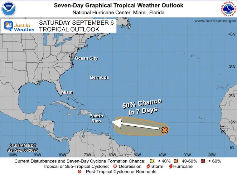
TROPICAL OUTLOOK
The storm in the Central Atlantic is running into upper-level wind shear, and the odds of development have dropped for the week ahead. There is still a chance, but it may be an uphill battle.
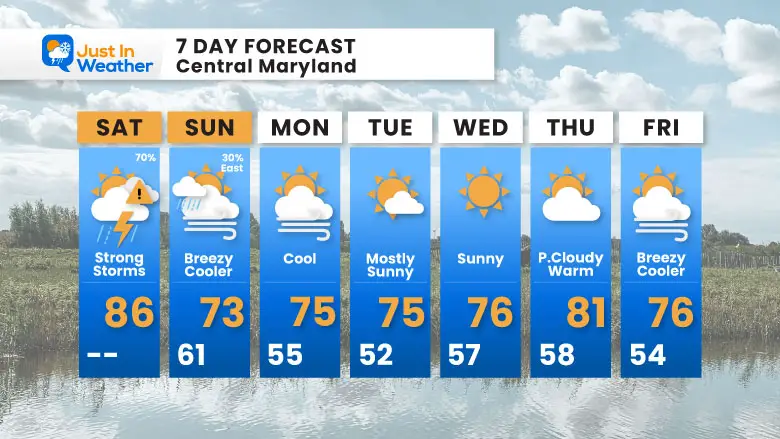
7 Day Forecast
- TODAY: Warm/Humid and Severe Storm Risk
- Sunday: Turning Breezy and Cooler
- Work Week: Remaining Below Average
Subscribe for eMail Alerts
Please share your thoughts and best weather pics/videos, or just keep in touch via social media.
THANK YOU:
Baltimore Sun Magazine Readers Choice Best Of Baltimore

RESTATING MY MESSAGE ABOUT DYSLEXIA
I am aware there are some spelling and grammar typos and occasional other glitches. I take responsibility for my mistakes and even the computer glitches I may miss. I have made a few public statements over the years, but if you are new here, you may have missed it: I have dyslexia and found out during my second year at Cornell University. It didn’t stop me from getting my meteorology degree and being the first to get the AMS CBM in the Baltimore/Washington region. One of my professors told me that I had made it that far without knowing and to not let it be a crutch going forward. That was Mark Wysocki, and he was absolutely correct! I do miss my mistakes in my own proofreading. The autocorrect spell check on my computer sometimes does an injustice to make it worse. I can also make mistakes in forecasting. No one is perfect at predicting the future. All of the maps and information are accurate. The ‘wordy’ stuff can get sticky. There has been no editor who can check my work while writing and to have it ready to send out in a newsworthy timeline. Barbara Werner is a member of the web team that helps me maintain this site. She has taken it upon herself to edit typos when she is available. That could be AFTER you read this. I accept this and perhaps proves what you read is really from me… It’s part of my charm. #FITF


