Wednesday, August 20 2025
Morning Report
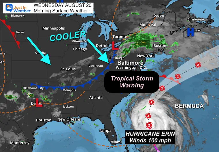
The clouds and cool winds we have locally today are from an East wind, and the water levels are already high.
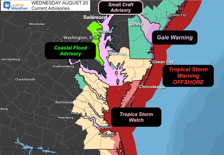
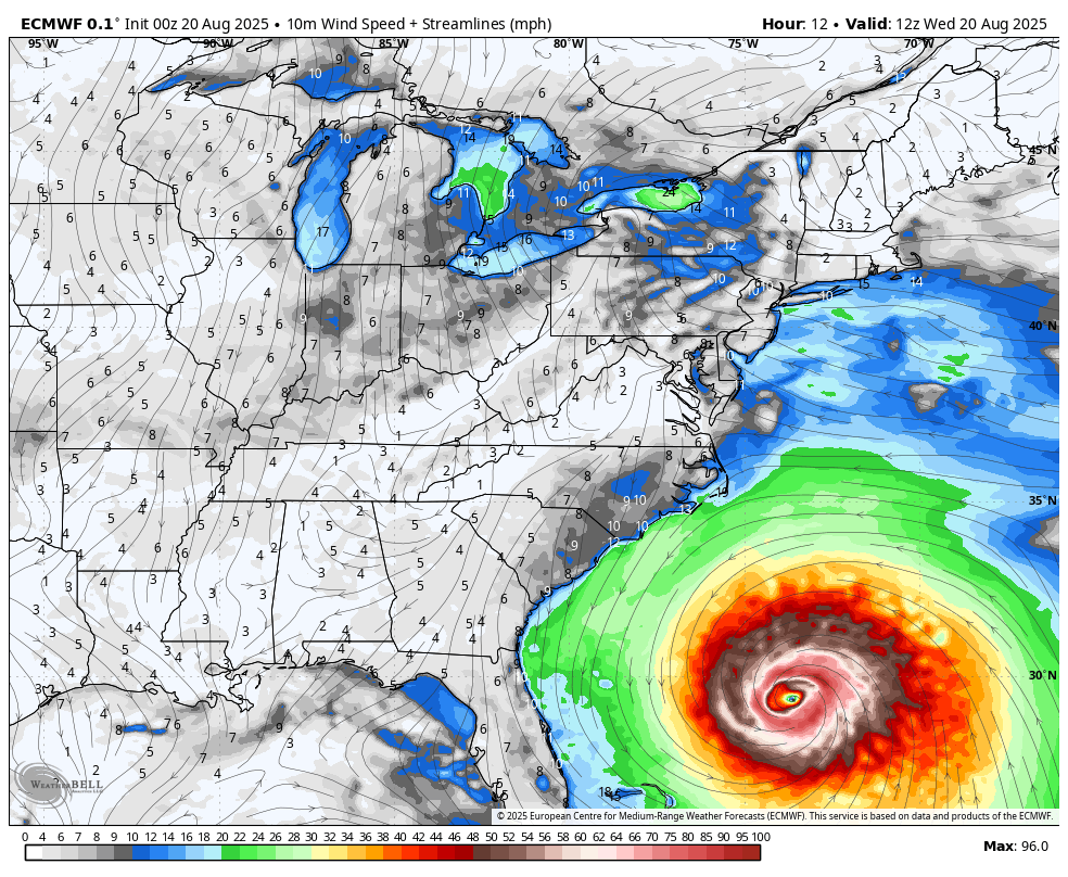
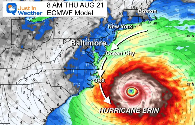
Hurricane Erin is still a Category 2 with 100 mph winds and will pass well offshore of the East Coast tomorrow. The strongest winds will be well offshore, but it has been growing larger in size. Due to that, it will bring tropical storm conditions to the coast. A Tropical Storm Warning has been posted for “waters” around Ocean City through Virginia And the North Carolina coasts.
This report will include a look at Hurricane Erin and our local weather.
Local Weather Alerts
Video: Ocean City MD Inlet
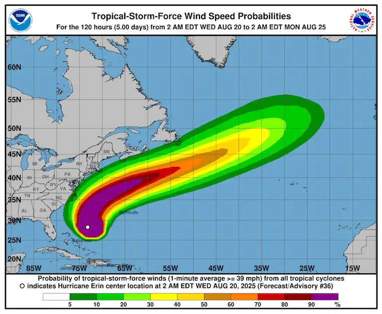
Tropical Outlook
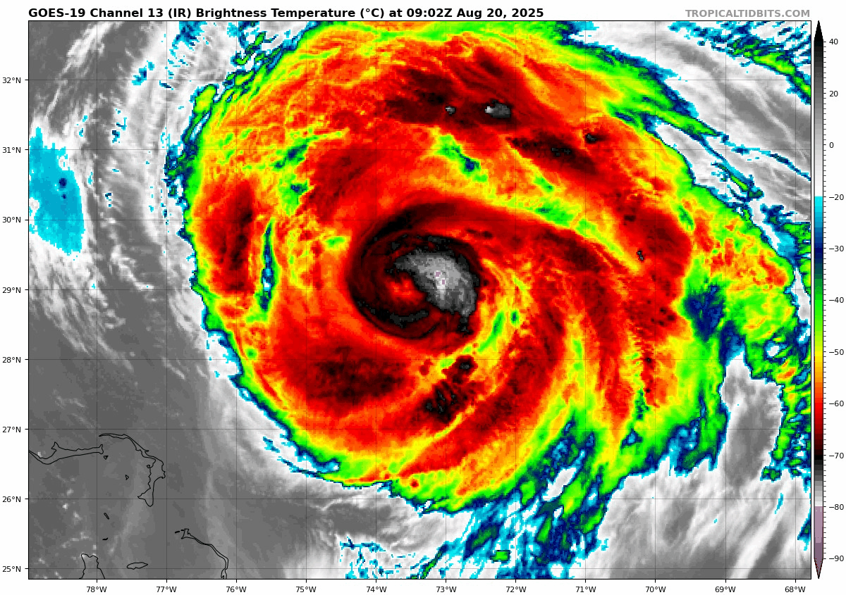
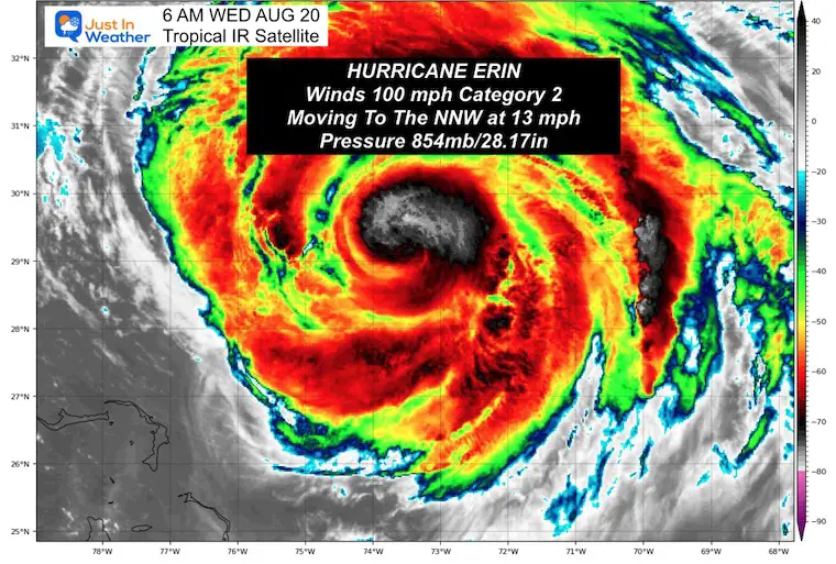
Hurricane Erin Satellite Loop
Winds were 100 mph, making this a Category 2. It is also larger in size. Hurricane Force Winds reach 90 miles from the center, Tropical Storm Force Winds extend 265 miles from the center.
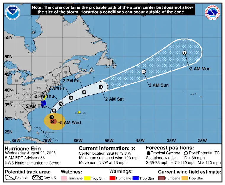
Update From The National Hurricane Center
- LOCATION…28.9N 73.3W
- ABOUT 555 MI…895 KM WSW OF BERMUDA
- ABOUT 455 MI…730 KM SSE OF CAPE HATTERAS NORTH CAROLINA
- MAXIMUM SUSTAINED WINDS…100 MPH…155 KM/H
- PRESENT MOVEMENT…NNW OR 345 DEGREES AT 13 MPH…20 KM/H
- MINIMUM CENTRAL PRESSURE…954 MB…28.17 INCHES
SUMMARY OF WATCHES AND WARNINGS IN EFFECT:
A Storm Surge Warning is in effect for…
* Cape Lookout to Duck, North Carolina
A Tropical Storm Warning is in effect for…
* Beaufort Inlet, North Carolina to the North Carolina/Virginia border, including Pamlico and Albemarle sounds.
A Tropical Storm Watch is in effect for…
* North of the North Carolina/Virginia border to Chincoteague, Virginia
* Bermuda
NHC Forecast Tracks
Still expected to pass well off the East coast AND West Of Bermuda.
NHC Forecast Winds
The path is likely to keep the core winds mostly offshore.
Reminder that the Tropical Storm Force Winds extend 265 miles from the center today.
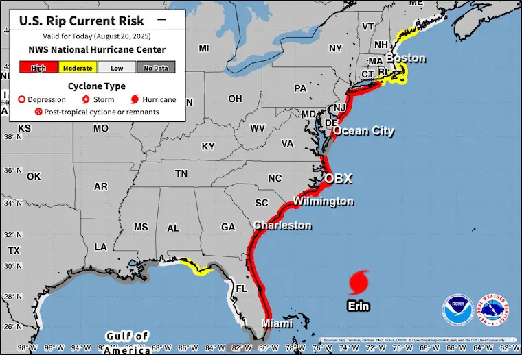
Rip Currents
Most of the US Coast – Beaches are closed to swimmers in most of these locations.
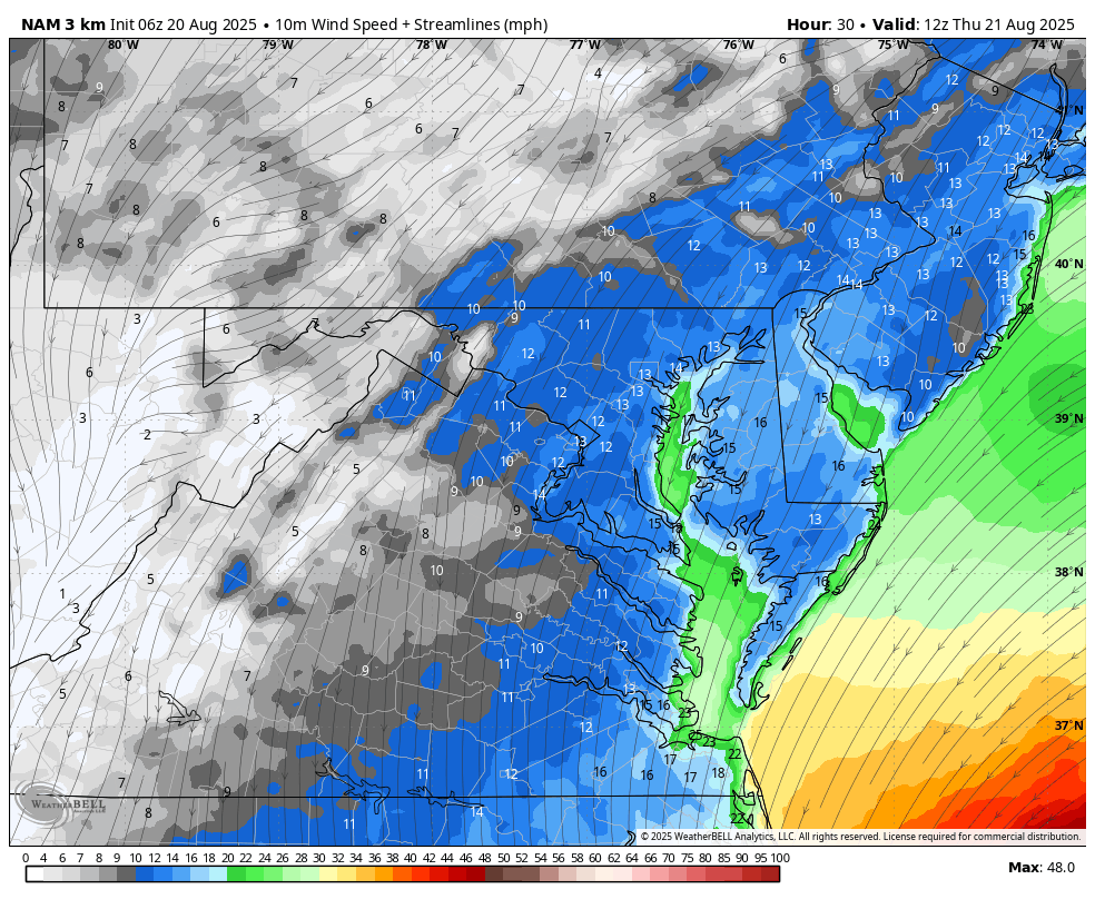
Wind Forecast: Wednesday Afternoon to Friday Afternoon
Snapshot Thursday Morning
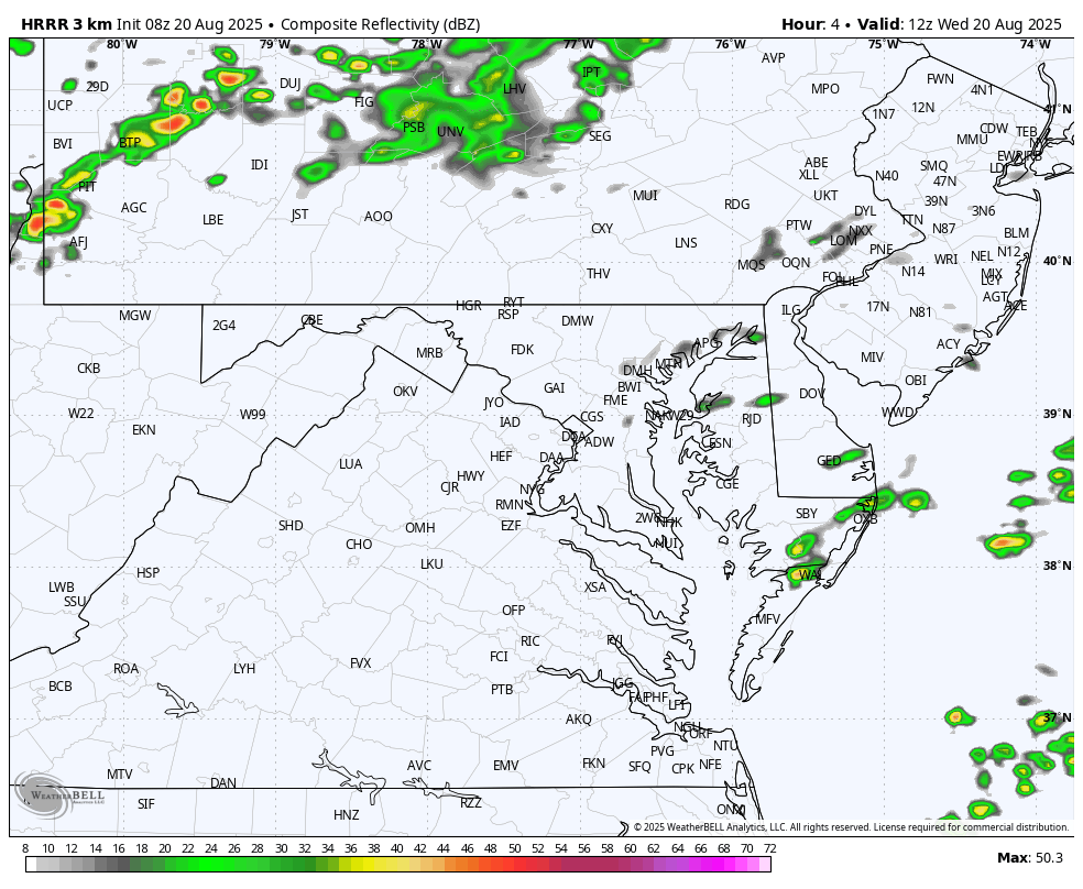
Local Weather Today
Surface Weather
Live Radar Widget
Radar Simulation
8 AM to 10 PM
Spotty showers pop during the day with some thunderstorms later into tonight. A few may have tropical-like downpours.
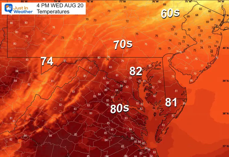
Afternoon Temperatures
CLIMATE DATA: Baltimore
Yesterday: Low 65F; High 75F
TODAY August 20
Sunrise at 6:25 AM
Sunset at 7:55 PM
Normal Low in Baltimore: 65ºF
Record 49ºF in 1998
Normal High in Baltimore: 86ºF
Record 105ºF 1983
Rainfall Deficit at BWI
- Ending 2024 = -8.00”
- Since Jan 1 = 1.21”
- We are STILL DOWN -9.21” INCLUDING LAST YEAR
Subscribe for eMail Alerts
Maryland Trek 12 Day 7 Completed Sat August 9
UPDATED: We raised OVER $162,000 for Just In Power Kids – AND Still Collecting More
The annual event: Hiking and biking 329 miles in 7 days between The Summit of Wisp to Ocean City.
Each day, we honor a kid and their family’s cancer journey.
Fundraising is for Just In Power Kids: Funding Free Holistic Programs. I never have and never will take a penny. It is all for our nonprofit to operate.
Click here or the image to donate:

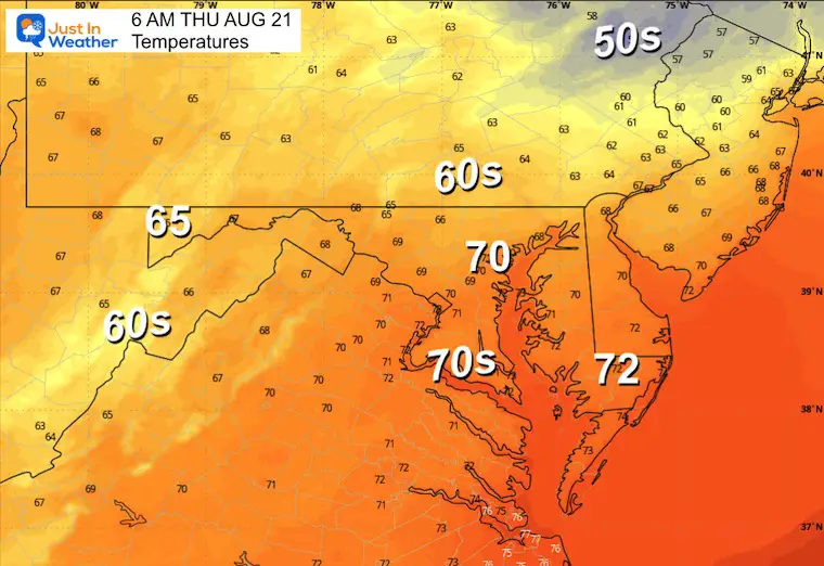
THURSDAY
Morning Temperatures
Wind Forecast
The East wind will keep us cloudy and cool and help to raise the water level on the Western Shore of the Bay.
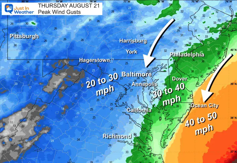
Peak Wind Gusts
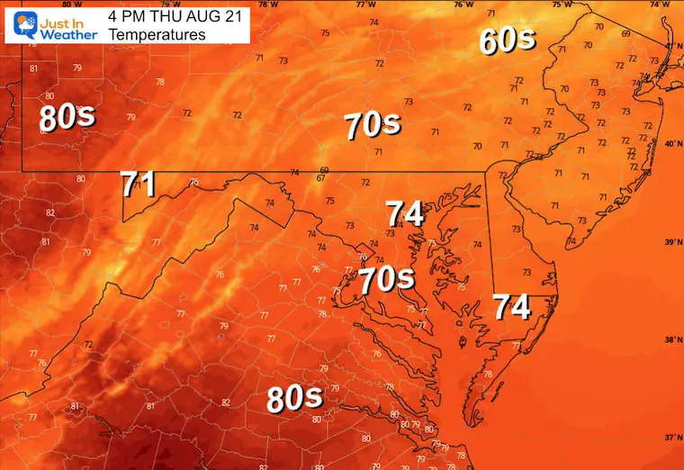
Afternoon Temperatures
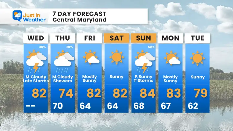
7 Day Forecast
- Impact From Erin Through Thursday
- Friday And Saturday: Clearing
- Sunday: T’Storms
Subscribe for eMail Alerts
Please share your thoughts and best weather pics/videos, or just keep in touch via social media.
THANK YOU:
Baltimore Sun Magazine Readers Choice Best Of Baltimore
RESTATING MY MESSAGE ABOUT DYSLEXIA
I am aware there are some spelling and grammar typos and occasional other glitches. I take responsibility for my mistakes and even the computer glitches I may miss. I have made a few public statements over the years, but if you are new here, you may have missed it: I have dyslexia and found out during my second year at Cornell University. It didn’t stop me from getting my meteorology degree and being the first to get the AMS CBM in the Baltimore/Washington region. One of my professors told me that I had made it that far without knowing and to not let it be a crutch going forward. That was Mark Wysocki, and he was absolutely correct! I do miss my mistakes in my own proofreading. The autocorrect spell check on my computer sometimes does an injustice to make it worse. I also can make mistakes in forecasting. No one is perfect at predicting the future. All of the maps and information are accurate. The ‘wordy’ stuff can get sticky. There has been no editor who can check my work while writing and to have it ready to send out in a newsworthy timeline. Barbara Werner is a member of the web team that helps me maintain this site. She has taken it upon herself to edit typos when she is available. That could be AFTER you read this. I accept this and perhaps proves what you read is really from me… It’s part of my charm. #FITF


