August 19, 2025
11:00 AM Tuesday
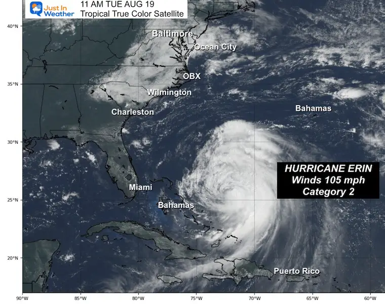
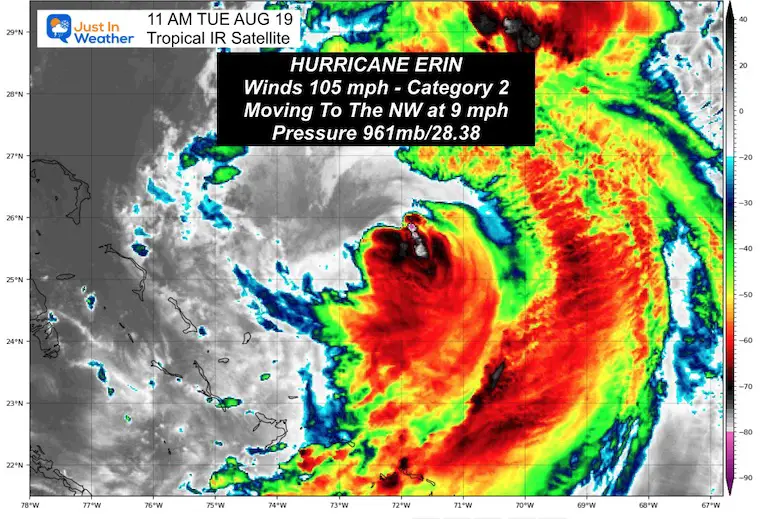
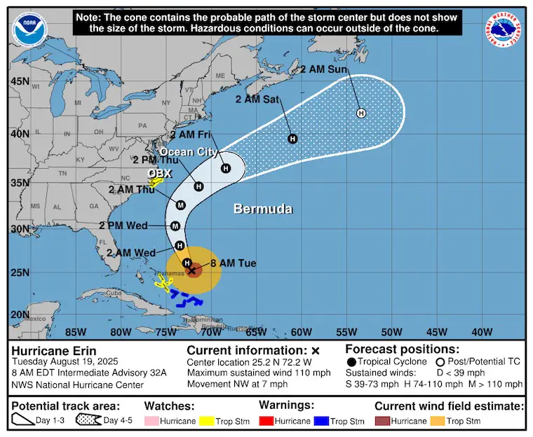
Hurricane Erin has dropped to a Category 2 intensity today. Winds were 110 mph in the 11 AM Update from the National Hurricane Center. This storm was never expected to make landfall, yet the forecast continues to show it growing larger in size. That’s common, especially with major hurricanes that move north and weaken.
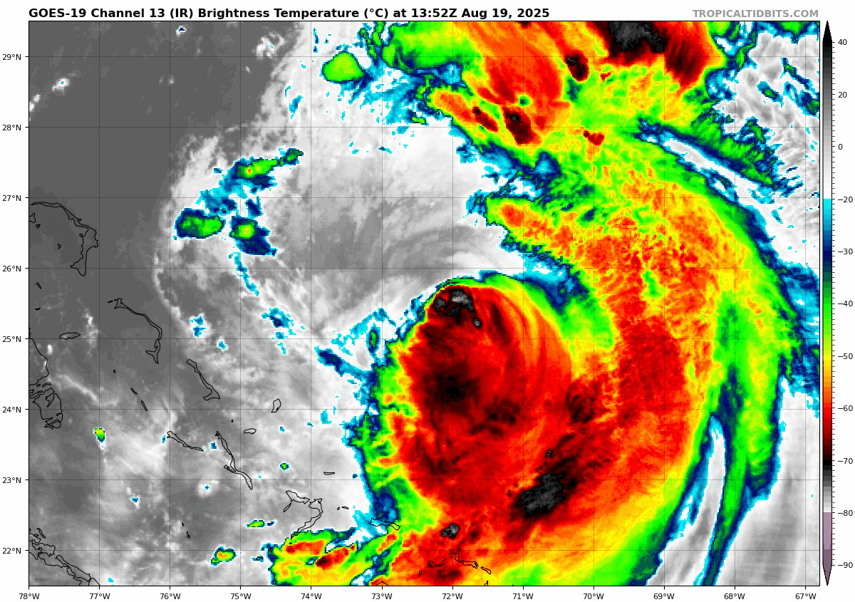
True Color Satellite Of Hurricane Erin
- Winds 105 mph
- 80 miles = Hurricane Force Winds
- 205 miles = Tropical Storm Force Winds
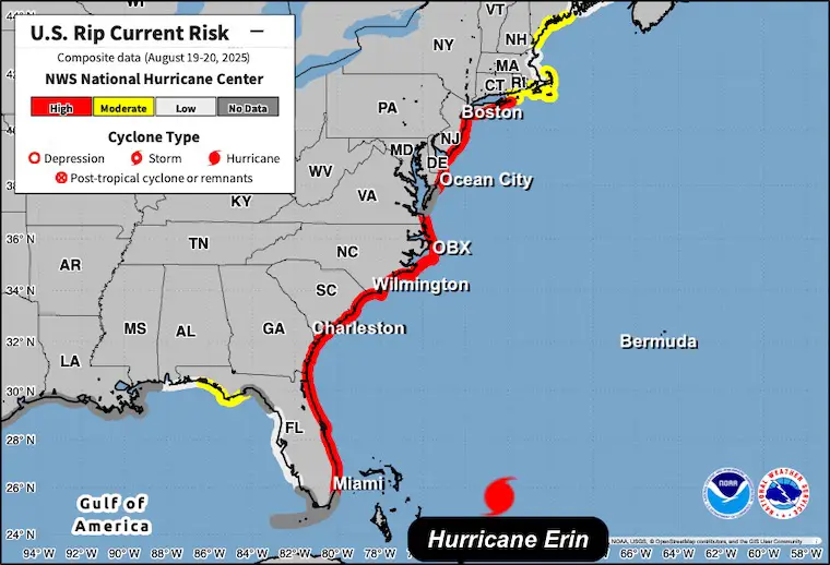
Rip Current Risk
Eastern US Today And Wednesday
IMPORTANT NOTES
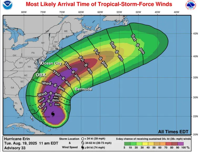
A Tropical Storm Watch is in place for the Mid-Atlantic coast between North Carolina and Maryland. This is NOT for a direct impact. The eye will remain a few hundred miles off the coast, so it will not make landfall. But the high water will pound Mid-Atlantic beaches with growing waves and beach erosion all week. Wind Gusts may reach over 40 mph, and an outer rain band may scrape the coast.
The worst conditions will be on Thursday as this makes the closest pass and turns away into the North Atlantic.
Video: Ocean City Inlet
This is from the East Winds In Place- NOT From Erin (yet)
Tropical Storm Watch And Warnings
This also includes a Storm Surge Watch and Small Craft Advisory
In this report, we will look at Hurricane Erin today and the impact on North Carolina and the rest of the Mid-Atlantic.
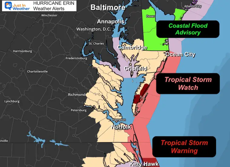
SUMMARY OF WATCHES AND WARNINGS IN EFFECT:
A Storm Surge Warning is in effect for…
* Cape Lookout to Duck, North Carolina
A Tropical Storm Warning is in effect for…
* Turks and Caicos Islands
* Southeast Bahamas
* Beaufort Inlet to Duck, North Carolina
A Tropical Storm Watch is in effect for…
* Central Bahamas
* North of Duck, North Carolina to Cape Charles Light, Virginia
* Coastal Waters Include Ocean City MD to Fenwick Island DE.
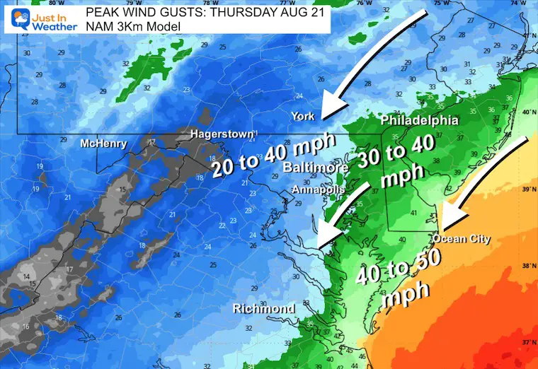
PEAK WINDS 30 to 40 mph with gusts to 50 mph. Potential up to 57 mph.
Local Forecast Maps
Wind Gust Swath Thursday
The direction from the northeast is important. It will be like a strong Nor’easter, with wind and waves following on the coast.
The Chesapeake Bay will have a ‘sloshing’ or piling up of higher water on the Western Shore. This may bring flooding to Baltimore County. It will bring flooding to Annapolis and southward.
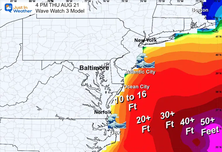
Wave Forecast
Update From The National Hurricane Center
11 AM Tuesday Aug 19
- LOCATION…25.6N 72.4W
- ABOUT 650 MI…1050 KM SW OF BERMUDA
- ABOUT 690 MI…1105 KM SSE OF CAPE HATTERAS NORTH CAROLINA
- MAXIMUM SUSTAINED WINDS…105 MPH…165 KM/H
- PRESENT MOVEMENT…NW OR 325 DEGREES AT 9 MPH…15 KM/H
- MINIMUM CENTRAL PRESSURE…961 MB…28.38 INCHES
Hurricane Erin Satellite Loop
Forecast Intensity
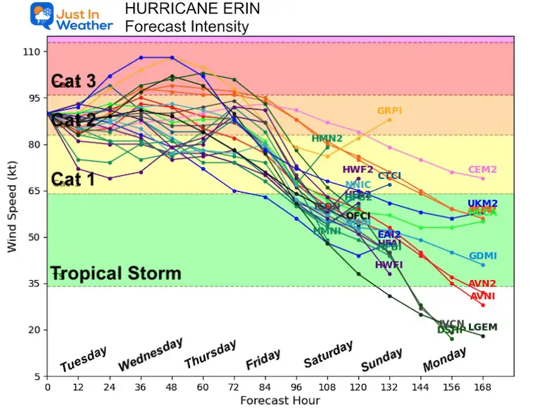
NHC Forecast Outlook…
Still expected to pass NORTH of the Caribbean Islands, East of The Bahamas, AND West of Bermuda.
NHC Forecast Winds (Over Tropical Storm Intensity)
European Model Forecast Simulation
Tuesday Afternoon to Friday Afternoon
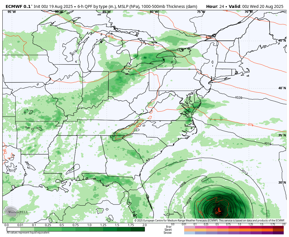
Snapshot Thursday
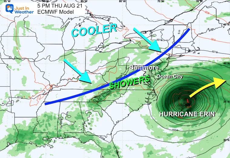
A cold front will approach the Eastern US, which will help steer Erin farther out to sea.
Wind Forecast:
Tuesday Afternoon to Friday Afternoon
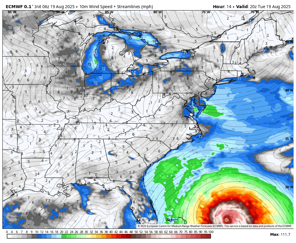
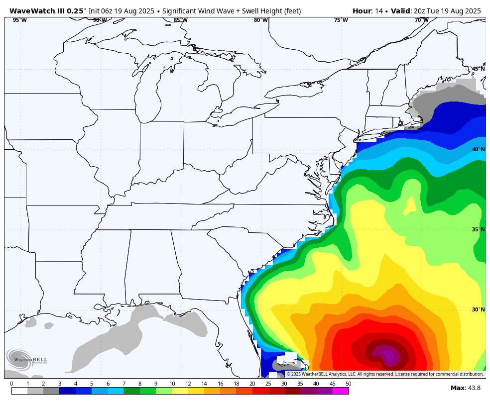
Wave Watch 3 Model
Tuesday Afternoon to Friday Afternoon
Here we can see the high water influence approaching the East Coast.
Yes, there will be rip currents and even high water up the Chesapeake Bay… but the worst will stay out to sea.
North Carolina Expectations
NOAA Tropical Storm Watch
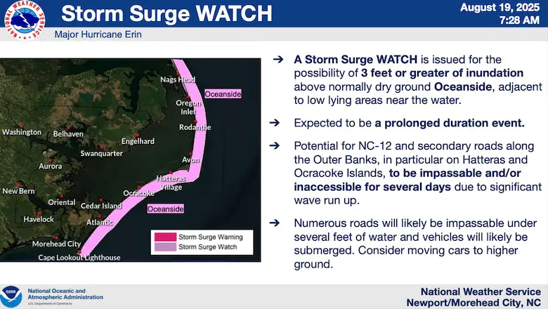
NOAA Storm Surge Watch
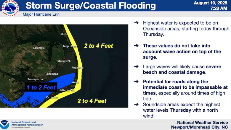
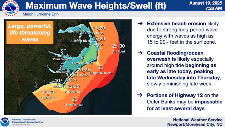
NOAA Max Wave Heights
Interactive Wind Widget
Subscribe for eMail Alerts
Please share your thoughts and best weather pics/videos, or just keep in touch via social media.
THANK YOU:
Baltimore Sun Magazine Readers Choice Best Of Baltimore
Maryland Trek 12 Day 7 Completed Sat August 9
UPDATED: We raised OVER $162,000 for Just In Power Kids – AND Still Collecting More
The annual event: Hiking and biking 329 miles in 7 days between The Summit of Wisp to Ocean City.
Each day, we honor a kid and their family’s cancer journey.
Fundraising is for Just In Power Kids: Funding Free Holistic Programs. I never have and never will take a penny. It is all for our nonprofit to operate.
Click here or the image to donate:

RESTATING MY MESSAGE ABOUT DYSLEXIA
I am aware there are some spelling and grammar typos and occasional other glitches. I take responsibility for my mistakes and even the computer glitches I may miss. I have made a few public statements over the years, but if you are new here, you may have missed it: I have dyslexia and found out during my second year at Cornell University. It didn’t stop me from getting my meteorology degree and being the first to get the AMS CBM in the Baltimore/Washington region. One of my professors told me that I had made it that far without knowing and to not let it be a crutch going forward. That was Mark Wysocki, and he was absolutely correct! I do miss my mistakes in my own proofreading. The autocorrect spell check on my computer sometimes does an injustice to make it worse. I also can make mistakes in forecasting. No one is perfect at predicting the future. All of the maps and information are accurate. The ‘wordy’ stuff can get sticky. There has been no editor who can check my work while writing and to have it ready to send out in a newsworthy timeline. Barbara Werner is a member of the web team that helps me maintain this site. She has taken it upon herself to edit typos when she is available. That could be AFTER you read this. I accept this and perhaps proves what you read is really from me… It’s part of my charm. #FITF


