Monday, August 18 2025
Morning Report
The strong storms that affected parts of the region yesterday were part of the cold front that moved through. This afternoon, we may end up 20 degrees cooler, along with brisk winds and high waves on local waters.
I want to start with a brief look at this, then include the forecast with our look into the week ahead as it will affect the waves across the US East Coast.
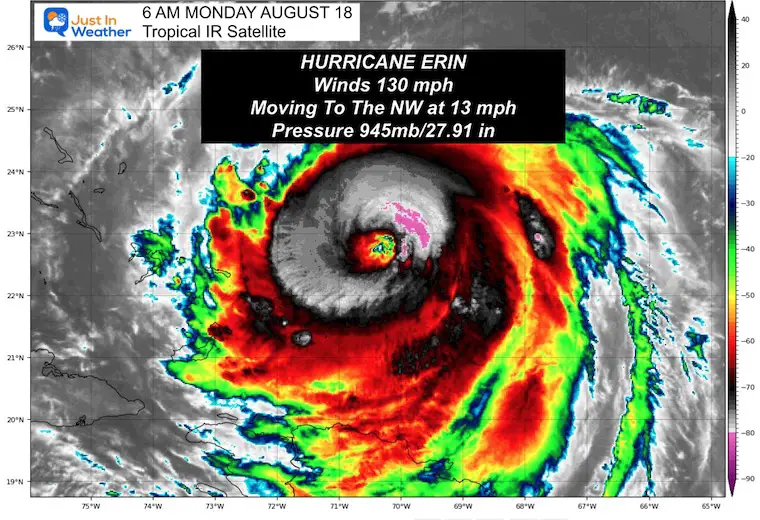
Hurricane Erin is separate but will begin to influence our weather in the next few days. Currently, the storm has regained some strength as expected, with winds at 130 mph. It is now a Category 4 Hurricane that has doubled in size and may double again as it travels north. The wind and waves will affect coastal areas along the Eastern Seaboard.
A State of Emergency has been issued with mandatory evacuations in Dare County on North Carolina’s Outer Banks.
I want to take a look at the storm, then our overall weather, and finally, the storm forecast for this week’s impact on our Mid-Atlantic region.
Tropical Outlook
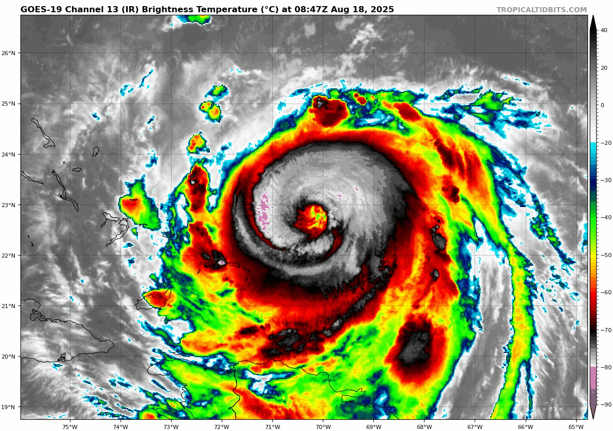
Hurricane Erin Satellite Loop
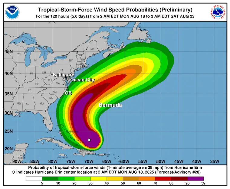
Winds were 130 mph, making this a Category 4. This regained strength also includes a larger size. Hurricane Force Winds reached 80 miles from the center, and Tropical Storm Force Winds extended 230 miles from the center.
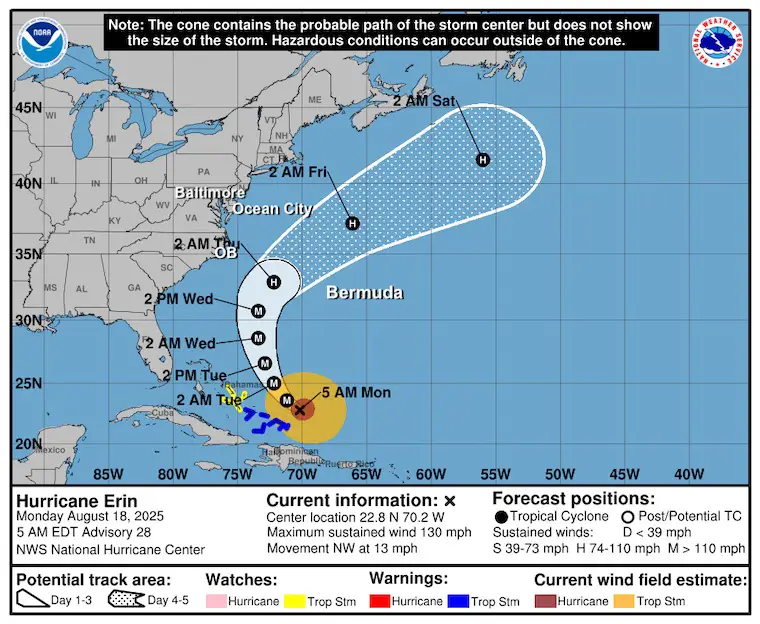
Update From The National Hurricane Center
- LOCATION…22.8N 70.2W
- ABOUT 105 MI…170 KM NNE OF GRAND TURK ISLAND
- ABOUT 915 MI…1470 KM SSE OF CAPE HATTERAS NORTH CAROLINA
- MAXIMUM SUSTAINED WINDS…130 MPH…215 KM/H
- PRESENT MOVEMENT…NW OR 305 DEGREES AT 13 MPH…20 KM/H
- MINIMUM CENTRAL PRESSURE…945 MB…27.91 INCHES
SUMMARY OF WATCHES AND WARNINGS IN EFFECT:
A Tropical Storm Warning is in effect for…
* Turks and Caicos Islands
* Southeast Bahamas
A Tropical Storm Watch is in effect for…
* Central Bahamas
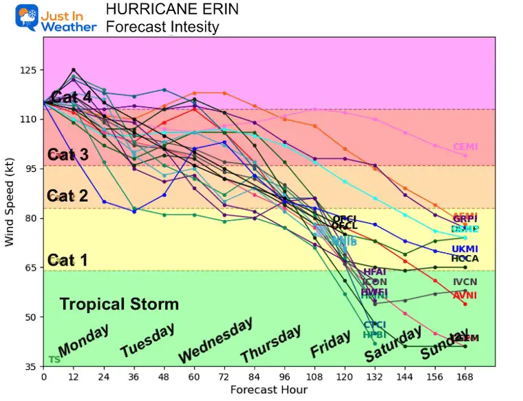
Forecast Intensity
Some fluctuations in strength over the next 48 hours before weakening as it curves north. Although warm Gulf Stream waters will provide support, increasing wind shear is expected to disrupt its structure.
NHC Forecast Tracks
Still expected to pass NORTH of the Caribbean Islands, East of The Bahamas, AND West of Bermuda.
NHC Forecast Winds
The path is likely to keep the core winds mostly offshore.
Reminder that the Tropical Storm Force Winds extend 205 miles from the center today. It will grow wider, but still pass between the US and Bermuda.
North Carolina Expectations
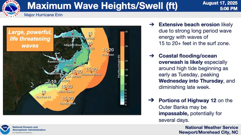
NOAA Wave Heights
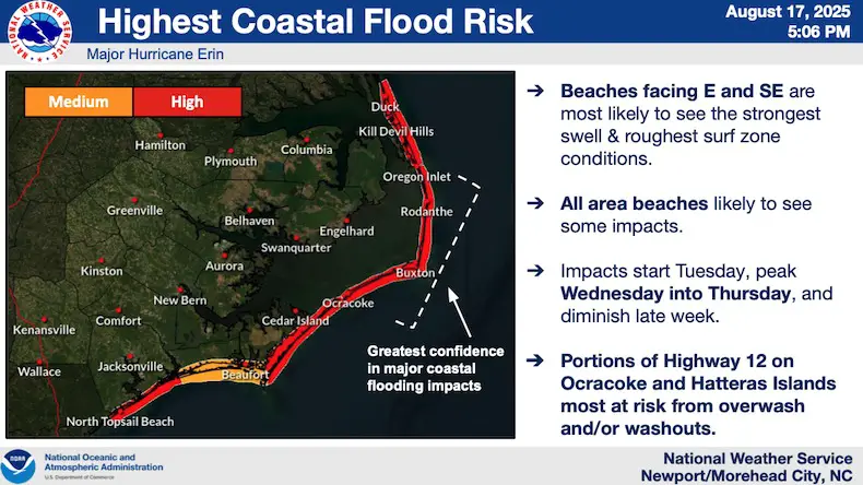
NOAA Coastal Flooding
Local Weather Today
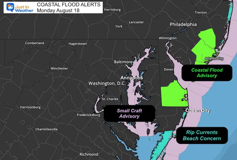
Coastal Flood Alerts
- Flood Advisory is in effect for Delaware to Southern New Jersey.
- Rip Current Concern for the Ocean City Beaches southward to Virginia.
- Small Craft Advisory along the Atlantic Coast AND Chesapeake Bay.
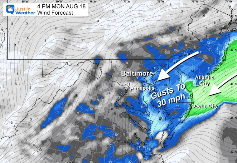
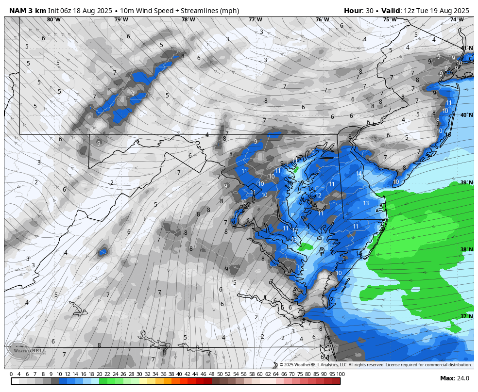
Wind Forecast This Afternoon
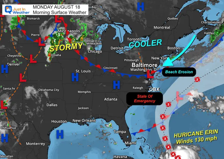
Surface Weather
The cold front that went through strong thunderstorms yesterday is now stalling to our south. We will stay on the cooler side for a few days.
This has opened up a steady wind from the Northeast. This will enhance the high water along the coast…
Hurricane Erin is still far away, but will be influencing our high water and winds mid-week.
Live Radar Widget
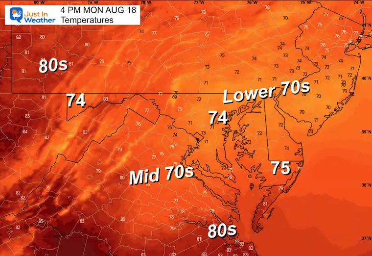
Afternoon Temperatures
CLIMATE DATA: Baltimore
Yesterday: Low 72F; High 94F
TODAY August 18
Sunrise at 6:23 AM
Sunset at 7:57 PM
Normal Low in Baltimore: 66ºF
Record 51ºF in 1918
Normal High in Baltimore: 87ºF
Record 96ºF 1995, 2002, 2019
Rainfall Deficit at BWI
- Ending 2024 = -8.00”
- Since Jan 1 = 0.99”
- We are STILL DOWN -8.99” INCLUDING LAST YEAR
Subscribe for eMail Alerts
Maryland Trek 12 Day 7 Completed Sat August 9
UPDATED: We raised OVER $161,000 for Just In Power Kids – AND Still Collecting More
The annual event: Hiking and biking 329 miles in 7 days between The Summit of Wisp to Ocean City.
Each day, we honor a kid and their family’s cancer journey.
Fundraising is for Just In Power Kids: Funding Free Holistic Programs. I never have and never will take a penny. It is all for our nonprofit to operate.
Click here or the image to donate:

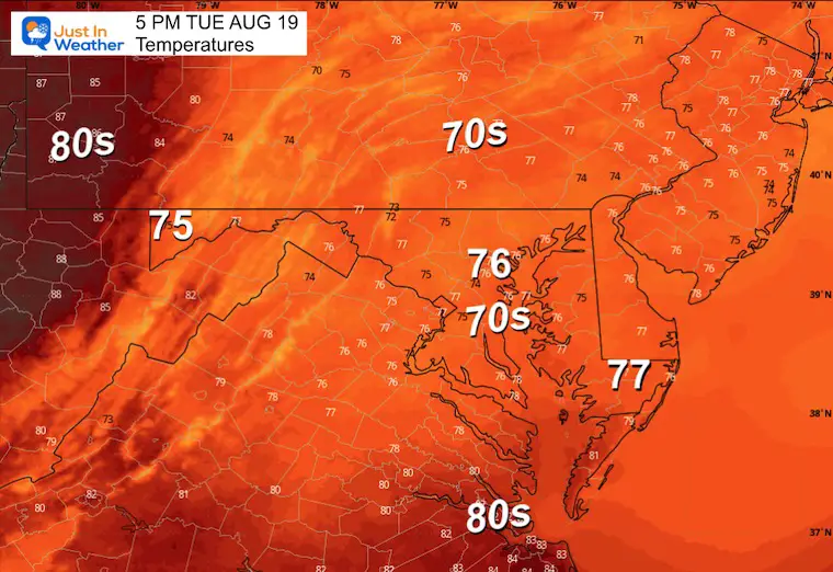
TUESDAY
We remain on the cooler side of this latest front. Winds will remain brisk from the East and Northeast, resulting in high water along the Atlantic Coast and Western Shore of the Chesapeake Bay.
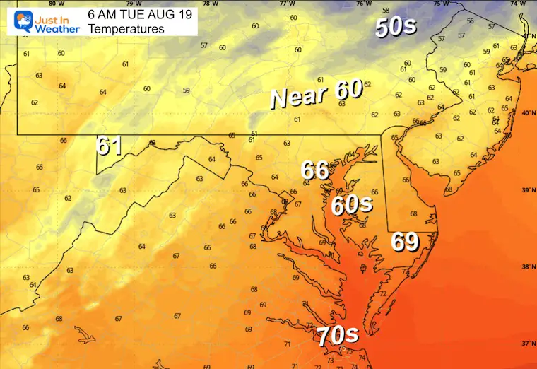
Morning Temperatures
Wind Forecast 8 AM to 4 PM
Gusts FROM THE EAST 20 to 30 mph.
Afternoon Temperatures
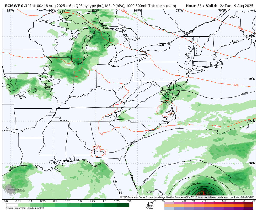
Forecast Including Hurricane Erin
ECMWF Model Animation:
Tuesday Aug 19 to Fri Aug 22
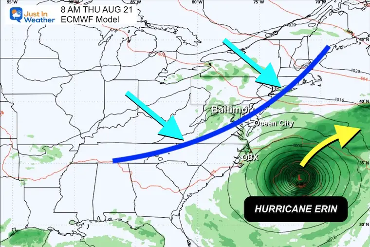
The typical curve is expected to pass well between the US and Bermuda.
The rain bands will affect the Northeast Caribbean Islands and the Outer Banks (OBX) of North Carolina. A cold front approaching from the Ohio Valley and Great Lakes will bring rain to the Mid Atlantic and keep Erin well offshore.
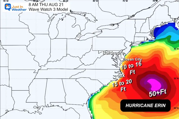
Snapshot Thursday Morning August 21
A cold front heading across the Ohio Valley is expected to help keep Erin off the coast.
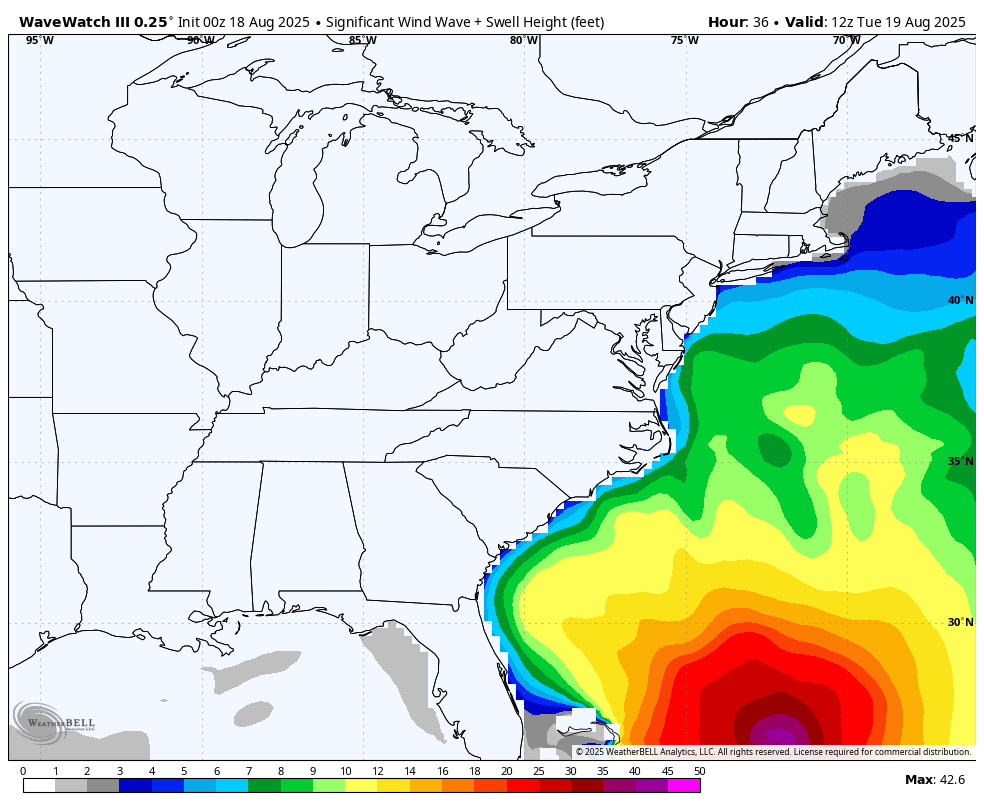
Wave Forecast East Coast
Tuesday To Friday
- Waves 10 to 16 Feet across the Mid Atlantic Coast.
- Waves Up To 20 Feet in Eastern North Carolina.
- Over 50 Foot waves near the center of the storm, well off the coast.
Snapshot Thursday
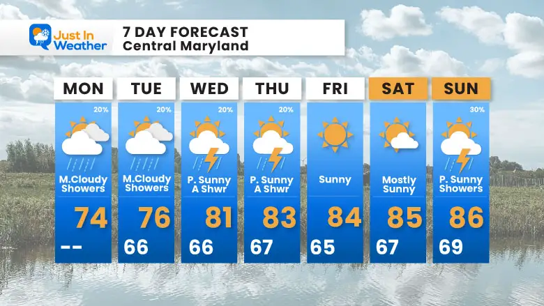
7 Day Forecast
Today: Cooler and Breezy
Gradual Warming With Main Concern For High Waves And Local Shoreline Flooding
Subscribe for eMail Alerts
Please share your thoughts and best weather pics/videos, or just keep in touch via social media.
THANK YOU:
Baltimore Sun Magazine Readers Choice Best Of Baltimore
RESTATING MY MESSAGE ABOUT DYSLEXIA
I am aware there are some spelling and grammar typos and occasional other glitches. I take responsibility for my mistakes and even the computer glitches I may miss. I have made a few public statements over the years, but if you are new here, you may have missed it: I have dyslexia and found out during my second year at Cornell University. It didn’t stop me from getting my meteorology degree and being the first to get the AMS CBM in the Baltimore/Washington region. One of my professors told me that I had made it that far without knowing and to not let it be a crutch going forward. That was Mark Wysocki, and he was absolutely correct! I do miss my mistakes in my own proofreading. The autocorrect spell check on my computer sometimes does an injustice to make it worse. I also can make mistakes in forecasting. No one is perfect at predicting the future. All of the maps and information are accurate. The ‘wordy’ stuff can get sticky. There has been no editor who can check my work while writing and to have it ready to send out in a newsworthy timeline. Barbara Werner is a member of the web team that helps me maintain this site. She has taken it upon herself to edit typos when she is available. That could be AFTER you read this. I accept this and perhaps proves what you read is really from me… It’s part of my charm. #FITF


