Sunday, August 17 2025
Morning Report
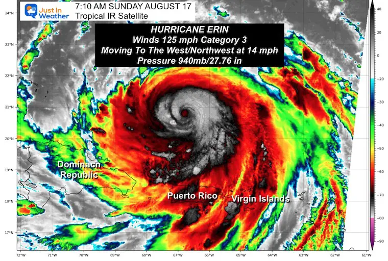
Two different issues to discuss this morning. Locally, the temperatures will be hot, and a line of thunderstorms will approach this evening to mark the arrival of cooler air for the work week. The other topic of concern is Hurricane Erin! After reaching Category 5 yesterday with 160 mph winds, it is back to Category 3 with 125 mph winds this morning. The outer bands are crossing the Virgin Islands and Puerto Rico. A Tropical Storm Warning was issued for the Turks and Caicos.
I want to start with a brief look at this, then include the forecast with our look into the week ahead, as it will affect the waves along the US East Coast.
Tropical Outlook
Video: Hurricane Erin Flight Through The Eye While Cat 5
Hurricane Hunter: 53rd Weather Reconnaissance Air Force Reserve
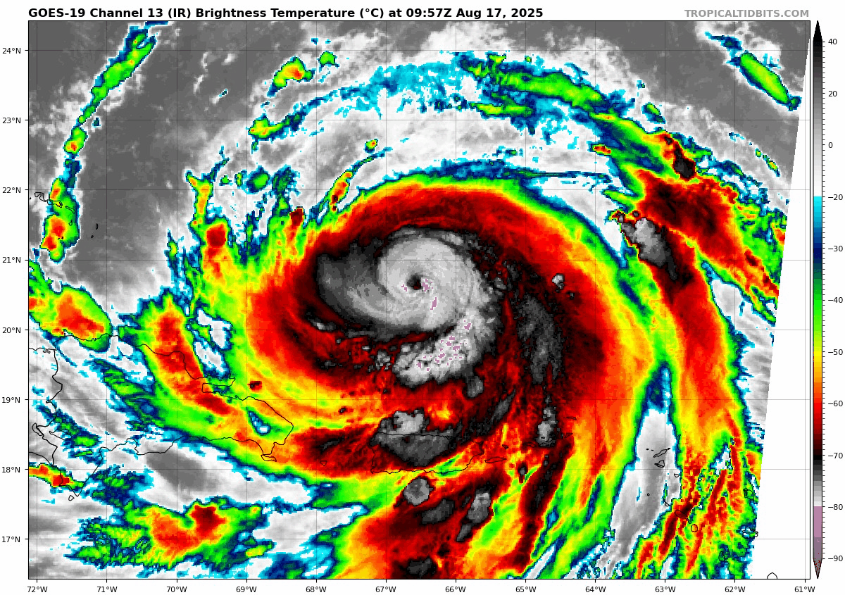
Hurricane Erin Satellite Loop
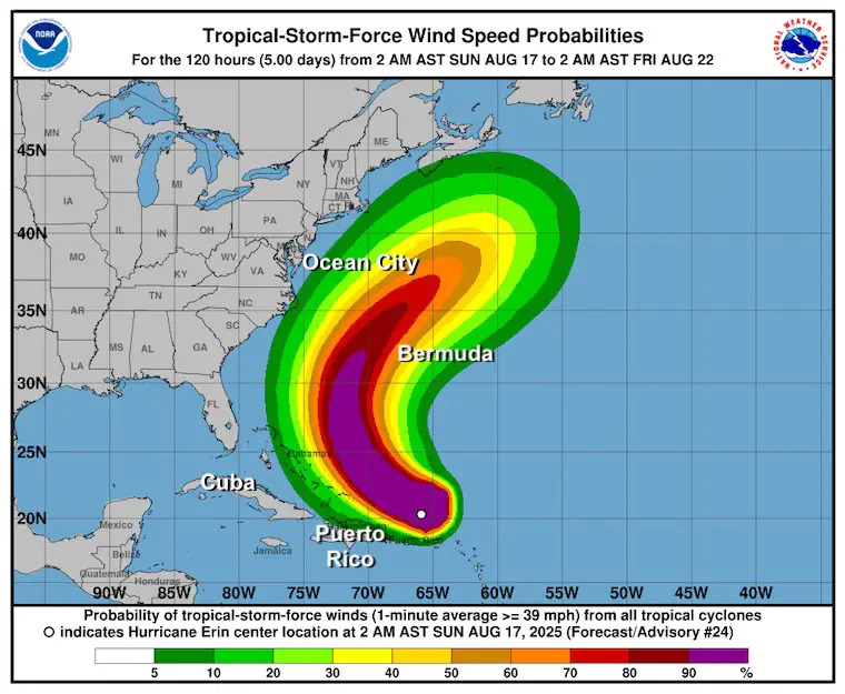
The winds were 125 mph, making this a Category 3. While it did weaken a little, it grew larger in size. Hurricane Force Winds reach 25 miles from the center, and Tropical Storm Force Winds extend 205 miles from the center.
Update From The National Hurricane Center
- LOCATION…20.6N 66.4W
- ABOUT 155 MI…245 KM N OF SAN JUAN PUERTO RICO
- ABOUT 310 MI…500 KM E OF GRAND TURK ISLAND
- MAXIMUM SUSTAINED WINDS…125 MPH…205 KM/H
- PRESENT MOVEMENT…WNW OR 285 DEGREES AT 14 MPH…22 KM/H
- MINIMUM CENTRAL PRESSURE…940 MB…27.76 INCHES
SUMMARY OF WATCHES AND WARNINGS IN EFFECT:
A Tropical Storm Warning is in effect for…
* Turks and Caicos Islands
A Tropical Storm Watch is in effect for…
* Southeast Bahamas
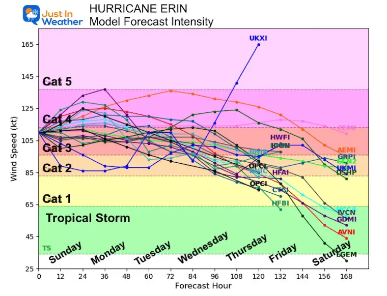
Forecast Intensity
Some variation in intensity over the next 48 hours, then weakening as it turns north. While the warm Gulf Stream provides support, increasing winds aloft as it moves north will deteriorate the storm’s structure.
National Hurricane Center Forecast Tracks
Still expected to pass NORTH of the Caribbean Islands, East of the Bahamas, AND West of Bermuda.
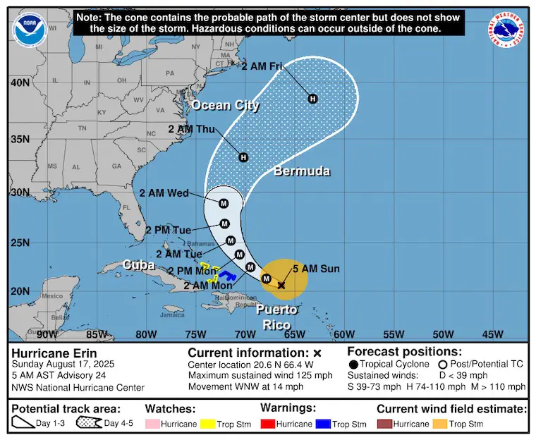
National Hurricane Center Forecast Winds
The path is likely to keep the core winds mostly offshore.
Reminder: Tropical Storm Force Winds extend 205 miles from the center today. It will grow wider, but still pass between the US and Bermuda.
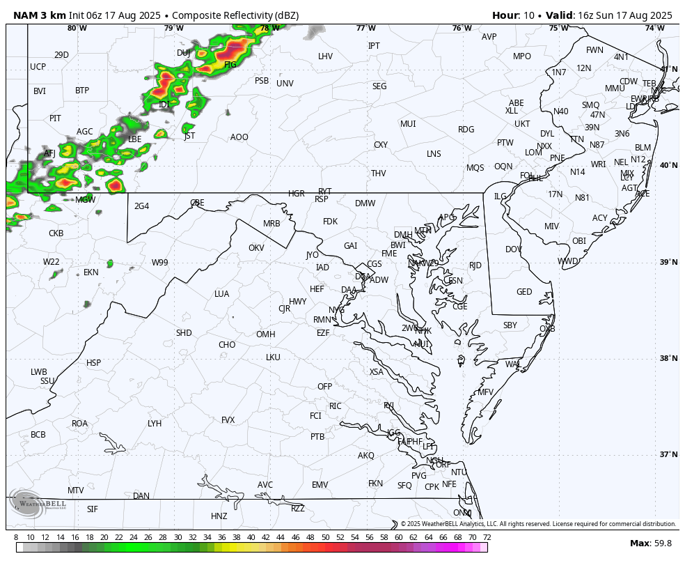
Local Weather Today
Surface Weather
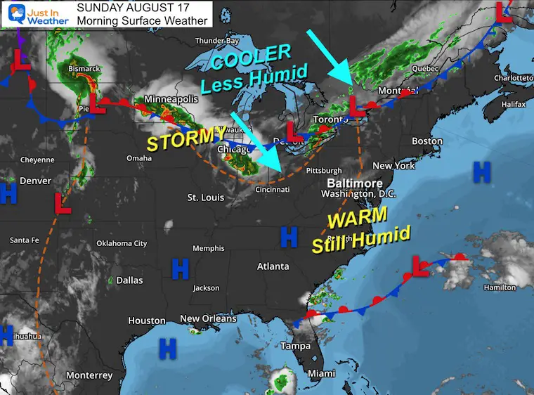
Today may be our last hot day for a while. The humidity didn’t really leave, but it will shortly.
A cold front will approach from the Northwest and bring in evening thunderstorms.
This front may stall for a few days, keeping clouds and showers around while we stay on the cooler side.
Live Radar Widget
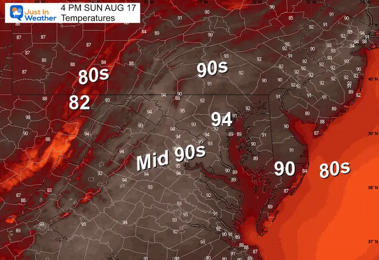
Afternoon Temperatures
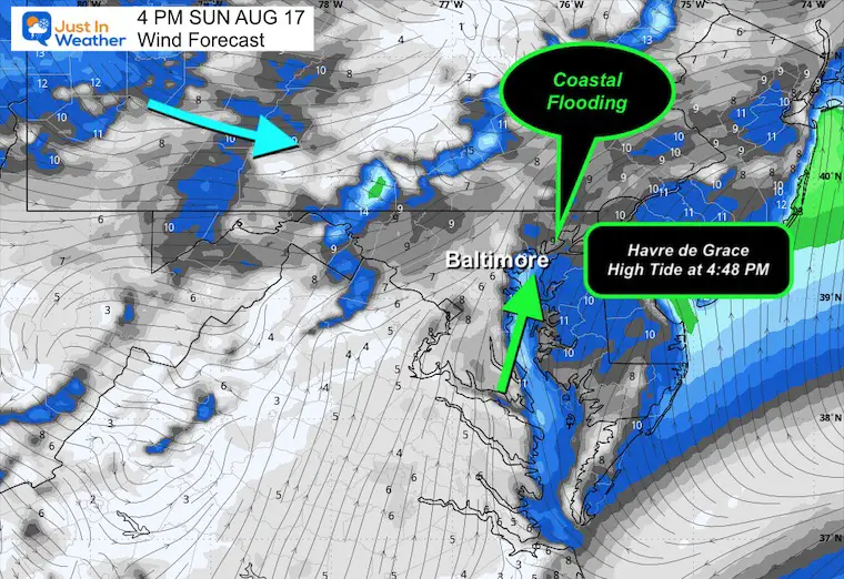
Wind Forecast And Coastal Flooding
There was already flooding near Havre de Grace at high tide this morning. There may be more inundation this afternoon with the next tidal swing this afternoon.
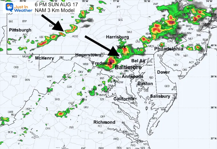
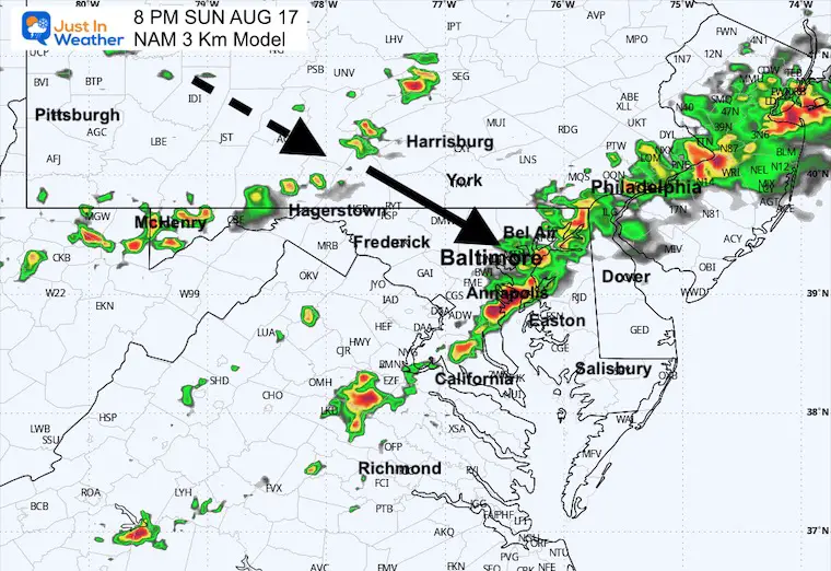
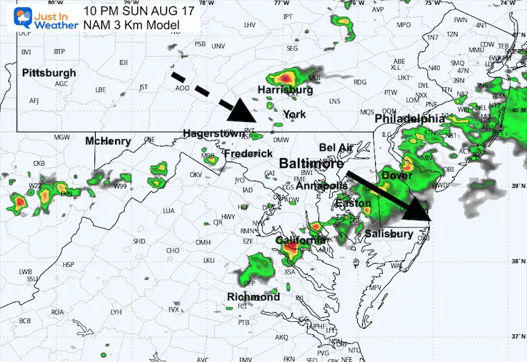
Radar Simulation: Noon to Midnight
Scattered thundershowers will form in the mountains and arrive FROM the West/Northwest.
Snapshot at 6 PM
Snapshot at 8 PM
Snapshot at 10 PM
CLIMATE DATA: Baltimore
Yesterday: Low 74F; High 89F
TODAY August 17
Sunrise at 6:22 AM
Sunset at 7:59 PM – Back BEFORE 8 PM
Normal Low in Baltimore: 66ºF
Record 53ºF in 1979
Normal High in Baltimore: 87ºF
Record 100ºF 1988
Rainfall Deficit at BWI
- Ending 2024 = -8.00”
- Since Jan 1 = 0.87”
- We are STILL DOWN -8.87” INCLUDING LAST YEAR
Subscribe for eMail Alerts
Maryland Trek 12 Day 7 Completed Sat August 9
UPDATED: We raised OVER $161,000 for Just In Power Kids – AND Still Collecting More
The annual event: Hiking and biking 329 miles in 7 days between The Summit of Wisp to Ocean City.
Each day, we honor a kid and their family’s cancer journey.
Fundraising is for Just In Power Kids: Funding Free Holistic Programs. I never have and never will take a penny. It is all for our nonprofit to operate.
Click here or the image to donate:

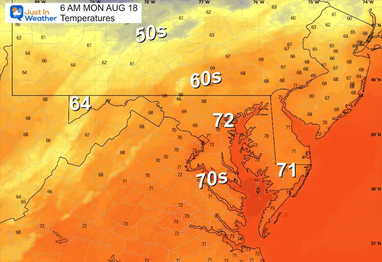
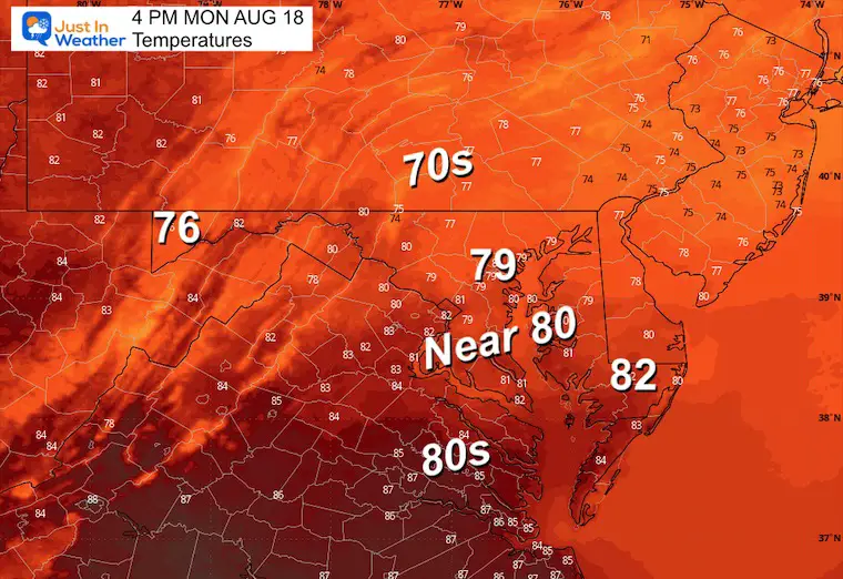
MONDAY
The front will stall to our south and keep clouds around with cooler air. Some showers will develop in the afternoon.
Morning Temperatures
Afternoon Temperatures
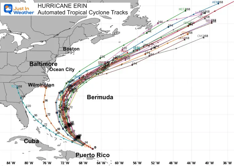
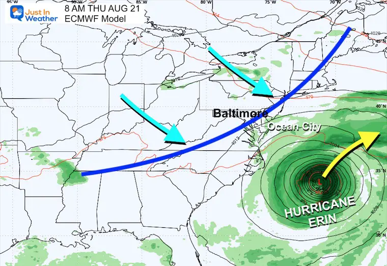
Forecast Including Hurricane Erin
Automate Tropical Cyclone Forecast Tracks
This expected track BETWEEN the US and Bermuda is holding up consistently.
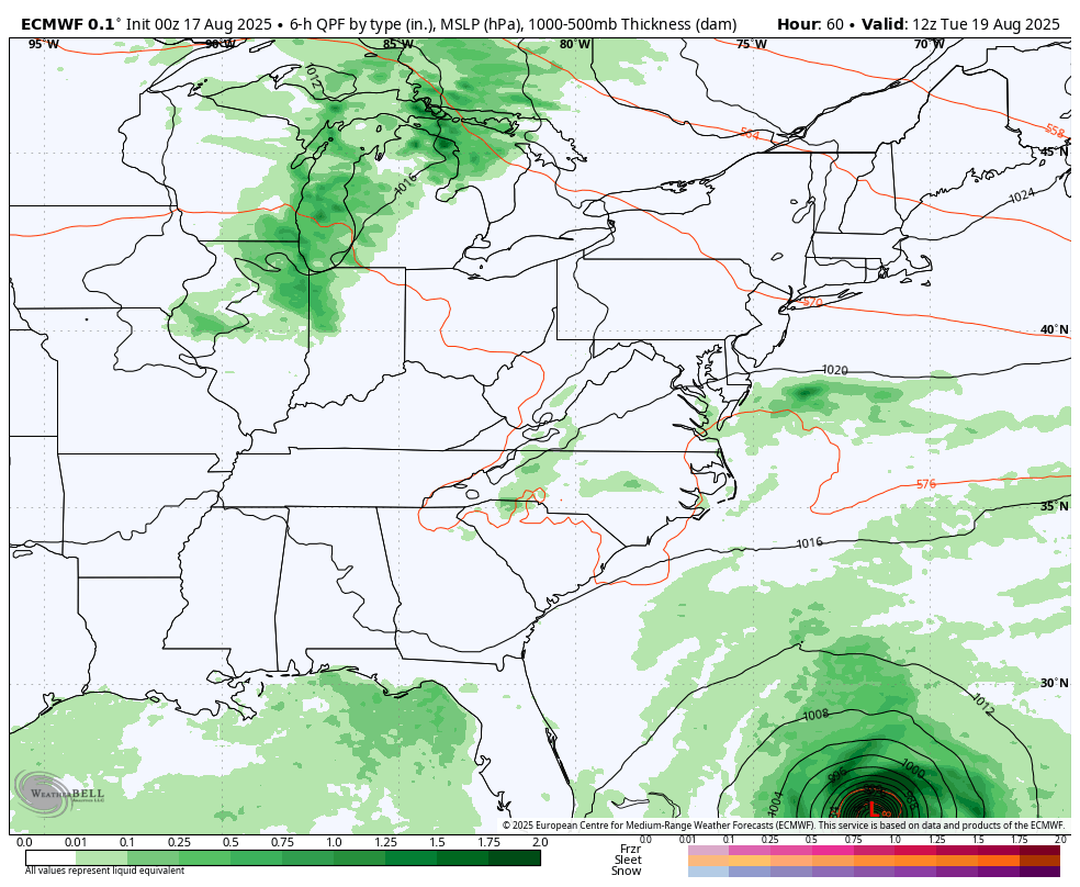
ECMWF Model Animation:
Tuesday Aug 19 to Friday Aug 22
The typical curve is expected to pass well between the US and Bermuda.
The rain bands will affect the Northeast Caribbean Islands and maybe the Outer Banks (OBX) of North Carolina. A cold front approaching from the Ohio Valley and Great Lakes will bring rain to the Mid Atlantic and keep Erin well offshore.
Snapshot Thursday Morning August 21
A cold front heading across the Ohio Valley is expected to help keep Erin off the coast.
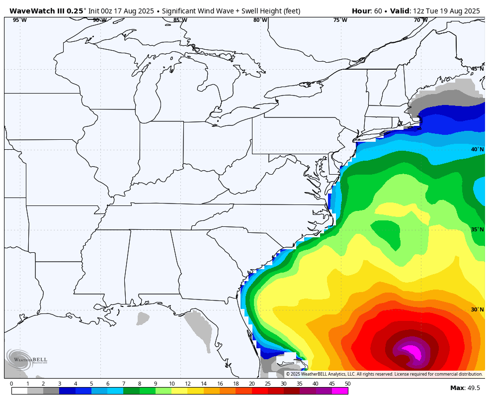
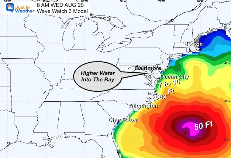
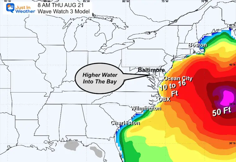
Wave Forecast East Coast
Tuesday To Friday
Waves 8 to 12 Feet across the Mid-Atlantic Coast.
Over 50 Foot waves near the center of the storm, well off the coast.
Snapshots
Wednesday
Thursday
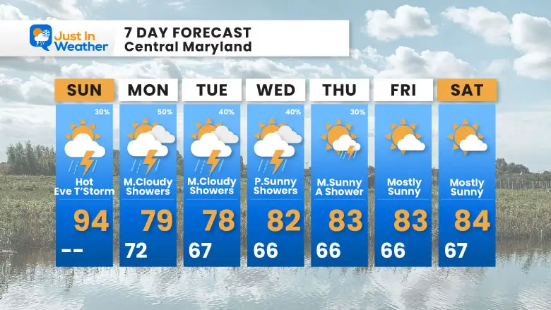
7 Day Forecast
Today: Hot; Evening T’Storm
Next Week: Cold Front Wednesday Will Push Erin Offshore
Subscribe for eMail Alerts
Please share your thoughts and best weather pics/videos, or just keep in touch via social media.
THANK YOU:
Baltimore Sun Magazine Readers Choice Best Of Baltimore
RESTATING MY MESSAGE ABOUT DYSLEXIA
I am aware there are some spelling and grammar typos and occasional other glitches. I take responsibility for my mistakes and even the computer glitches I may miss. I have made a few public statements over the years, but if you are new here, you may have missed it: I have dyslexia and found out during my second year at Cornell University. It didn’t stop me from getting my meteorology degree and being the first to get the AMS CBM in the Baltimore/Washington region. One of my professors told me that I had made it that far without knowing and to not let it be a crutch going forward. That was Mark Wysocki, and he was absolutely correct! I do miss my mistakes in my own proofreading. The autocorrect spell check on my computer sometimes does an injustice to make it worse. I also can make mistakes in forecasting. No one is perfect at predicting the future. All of the maps and information are accurate. The ‘wordy’ stuff can get sticky. There has been no editor who can check my work while writing and to have it ready to send out in a newsworthy timeline. Barbara Werner is a member of the web team that helps me maintain this site. She has taken it upon herself to edit typos when she is available. That could be AFTER you read this. I accept this and perhaps proves what you read is really from me… It’s part of my charm. #FITF


