August 16 2025
2:30 PM Saturday
Since 1924, there have been 43 documented Category 5 hurricanes in the Atlantic. Of them, Erin has become the 10th to form in August. This ranks second next to September, which has had 25 Category 5 storms.
A category 5 storm has winds of 157 mph or higher. About 3.5% of hurricanes in the Atlantic reach Category 5, so this is a rare occurrence. The conditions need to be ideal, and that is where we are today.
This morning, the National Weather Service reported that a Hurricane Hunter flight documented winds of 160 mph, putting Hurricane Erin in this category. Now, at 2 PM, we have a full update and computer model forecast simulation from the morning data run. Here is the latest.
I have watched the path track more due west than expected, thus staying a little farther south. It will still turn North and curve away from the US East Coast, but it may be a little closer, resulting in slightly higher waves from Tuesday to Thursday. Also, higher water will push into the Chesapeake Bay, but the worst will remain well offshore.
NHC Notes
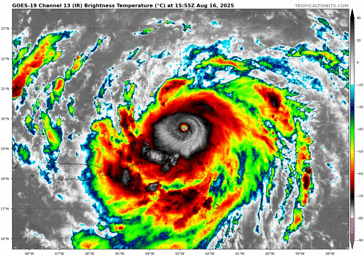
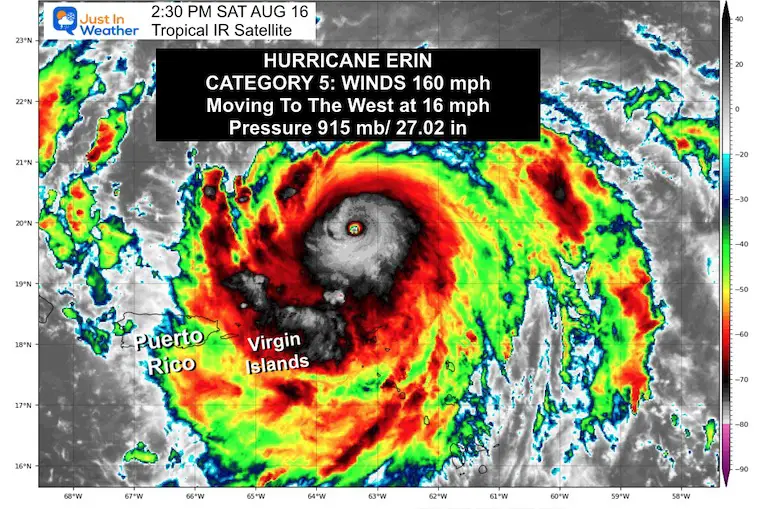
Reports from an Air Force Reserve Hurricane Hunter aircraft indicate that maximum sustained winds are near 160 mph (260 km/h) with higher gusts. Erin is a category 5 hurricane on the Saffir-Simpson Hurricane Wind Scale. Some strengthening is possible this afternoon. Fluctuations in intensity are expected for the rest of the weekend.
Tropical Outlook
Hurricane Erin Satellite
The winds were 160 mph! Hurricane Force Winds reached 30 miles from the center, and Tropical Storm Force Winds extended 140 miles from the center.
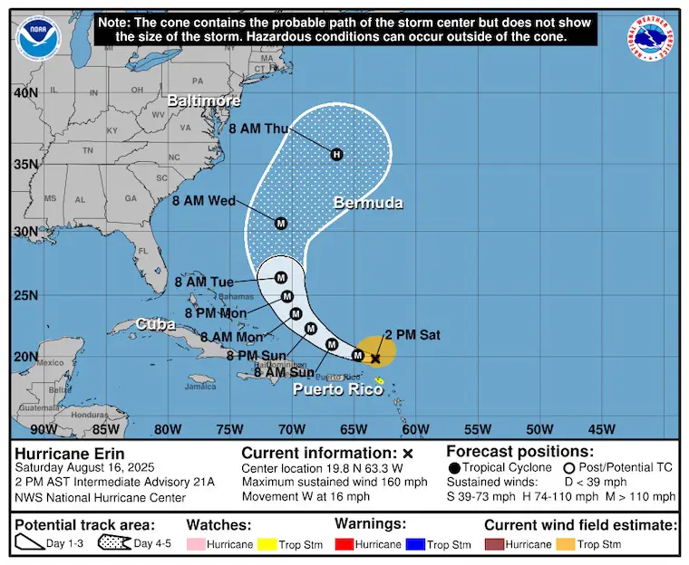
Update From The National Hurricane Center
2 PM Sat Aug 16
- LOCATION…19.8N 63.3W
- ABOUT 110 MI…180 KM N OF ANGUILLA
- ABOUT 205 MI…335 KM ENE OF SAN JUAN PUERTO RICO
- MAXIMUM SUSTAINED WINDS…160 MPH…260 KM/H
- PRESENT MOVEMENT…W OR 280 DEGREES AT 16 MPH…26 KM/H
- MINIMUM CENTRAL PRESSURE…915 MB…27.02 INCHES
A Tropical Storm Watch is in effect for…
- St. Martin and St. Barthelemy
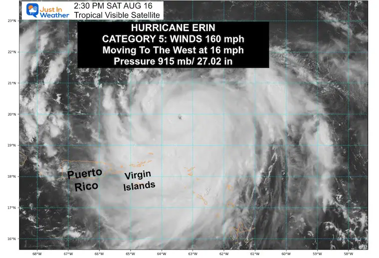
Visible Satellite
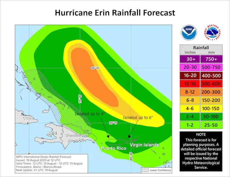
RAINFALL:
The outer bands of Erin are expected to continue producing areas of heavy rainfall through Sunday across the northern Leeward Islands, the Virgin Islands, and Puerto Rico. Rainfall totals of 2 to 4 inches, with isolated totals of 6 inches, are expected. Locally considerable flash and urban flooding, along with landslides or mudslides, are possible.
Forecast Intensity
Now at Major Hurricane Ranking, it is expected to remain as such while passing over very warm water. It will gradually weaken as it pushes farther north into colder water.
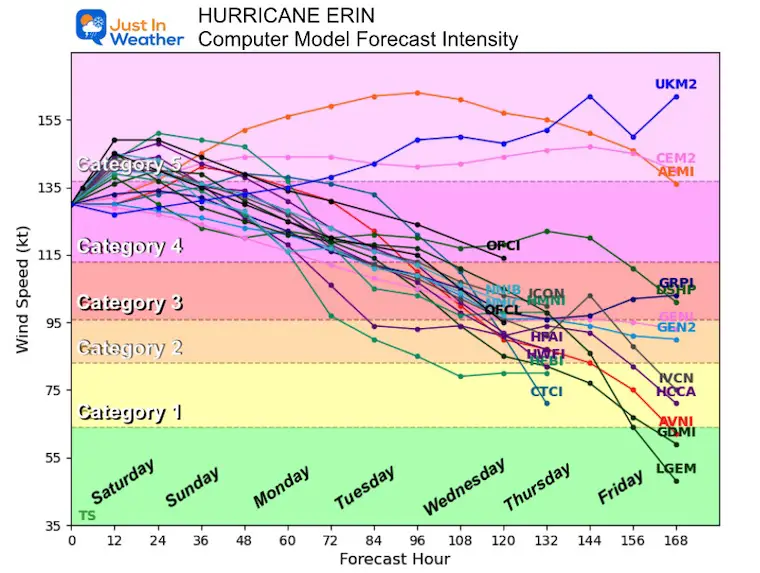
NHC Forecast Outlook…
Still expected to pass NORTH of the Caribbean Islands, East of The Bahamas, AND West of Bermuda.
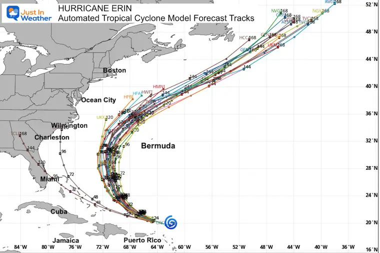
Automate Tropical Cyclone Forecast Tracks
This expected track BETWEEN the US and Bermuda is holding up consistently.
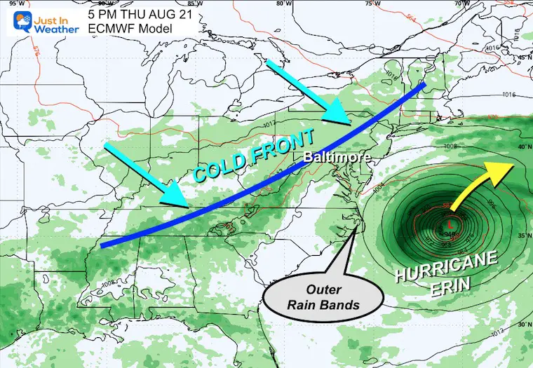
European Model Forecast Simulation
Tuesday Morning to Friday Morning
A cold front will approach the Eastern US, which will help steer Erin farther out to sea.
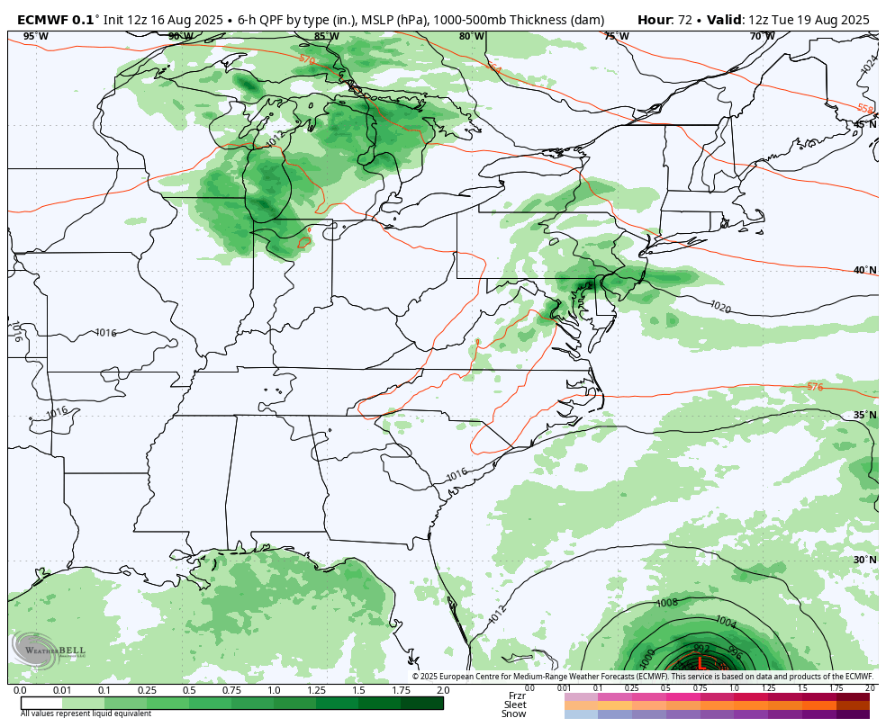
Snapshot Thursday Afternoon
The closest approach with showers and thunderstorms NOT related to Hurricane Erin.
The outer bands may clip the North Carolina Outer Banks and perhaps Delmarva.
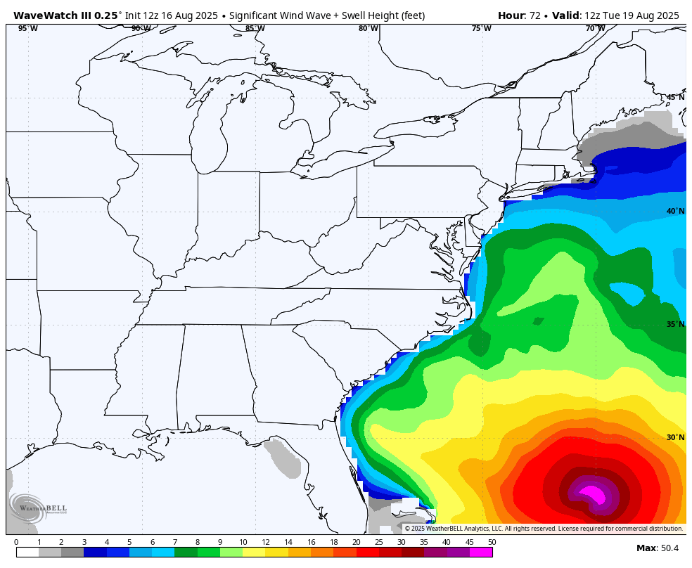
Wave Watch 3 Model
Tuesday Morning to Friday Morning
Here we can see the high water influence approaching the East Coast.
Yes, there will be rip currents and even high water up the Chesapeake Bay… but the worst will stay out to sea.
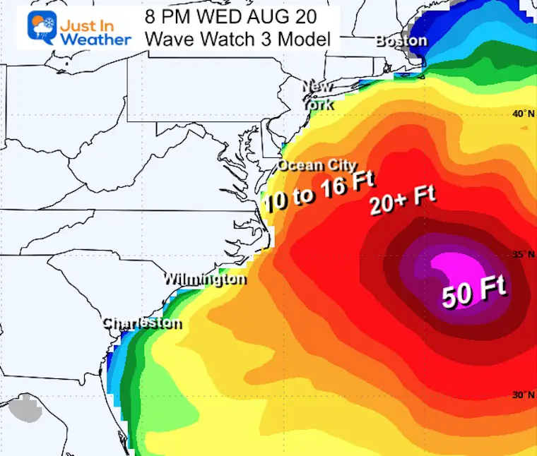
Snapshot Thursday Afternoon
Peak Waves may reach 10′ to 16′. This may be good news for surfers, but coastal beach erosion is also expected.
Interactive Wind Widget
Subscribe for eMail Alerts
Please share your thoughts and best weather pics/videos, or just keep in touch via social media.
Maryland Trek 12 Day 7 Completed Sat August 9
UPDATED: We raised OVER $161,000 for Just In Power Kids – AND Still Collecting More
The annual event: Hiking and biking 329 miles in 7 days between The Summit of Wisp to Ocean City.
Each day, we honor a kid and their family’s cancer journey.
Fundraising is for Just In Power Kids: Funding Free Holistic Programs. I never have and never will take a penny. It is all for our nonprofit to operate.
Click here or the image to donate:

THANK YOU:
Baltimore Sun Magazine Readers Choice Best Of Baltimore
RESTATING MY MESSAGE ABOUT DYSLEXIA
I am aware there are some spelling and grammar typos and occasional other glitches. I take responsibility for my mistakes and even the computer glitches I may miss. I have made a few public statements over the years, but if you are new here, you may have missed it: I have dyslexia and found out during my second year at Cornell University. It didn’t stop me from getting my meteorology degree and being the first to get the AMS CBM in the Baltimore/Washington region. One of my professors told me that I had made it that far without knowing and to not let it be a crutch going forward. That was Mark Wysocki, and he was absolutely correct! I do miss my mistakes in my own proofreading. The autocorrect spell check on my computer sometimes does an injustice to make it worse. I also can make mistakes in forecasting. No one is perfect at predicting the future. All of the maps and information are accurate. The ‘wordy’ stuff can get sticky. There has been no editor who can check my work while writing and to have it ready to send out in a newsworthy timeline. Barbara Werner is a member of the web team that helps me maintain this site. She has taken it upon herself to edit typos when she is available. That could be AFTER you read this. I accept this and perhaps proves what you read is really from me… It’s part of my charm. #FITF


