Friday, August 15 2025
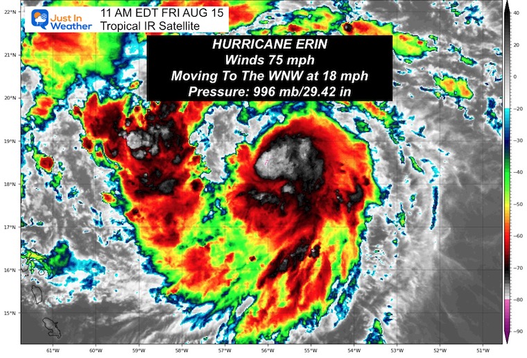
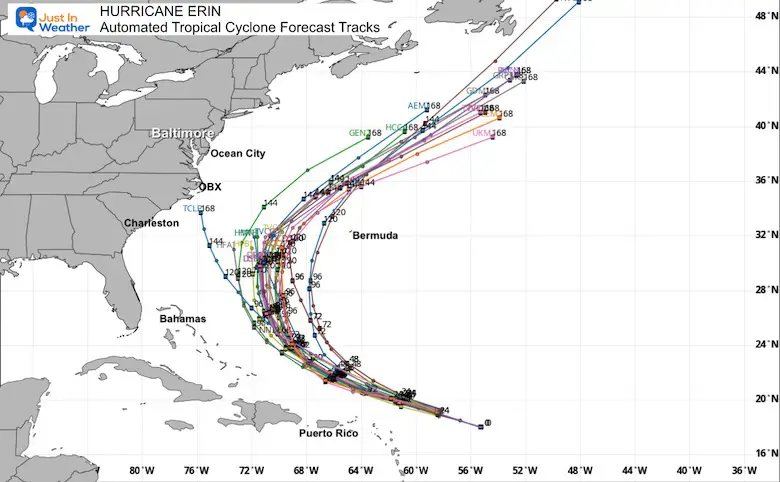
Hurricane Erin is the official term now, the 5th named storm of the season, and has become the first hurricane in the Atlantic. Winds are now 75 mph and intensifying as forecast. Over the next few days, the conditions support more organization and rapid growth. The expectation is for this storm to reach Category 3 intensity and become a major hurricane over the weekend. The forecast track continues to keep this north of the Caribbean, East of the Bahamas, and West of Bermuda. Threading the needle with the eye is one thing, but there will still be an impact with outer rain bands, and large waves will impact these areas. Here is the latest update.
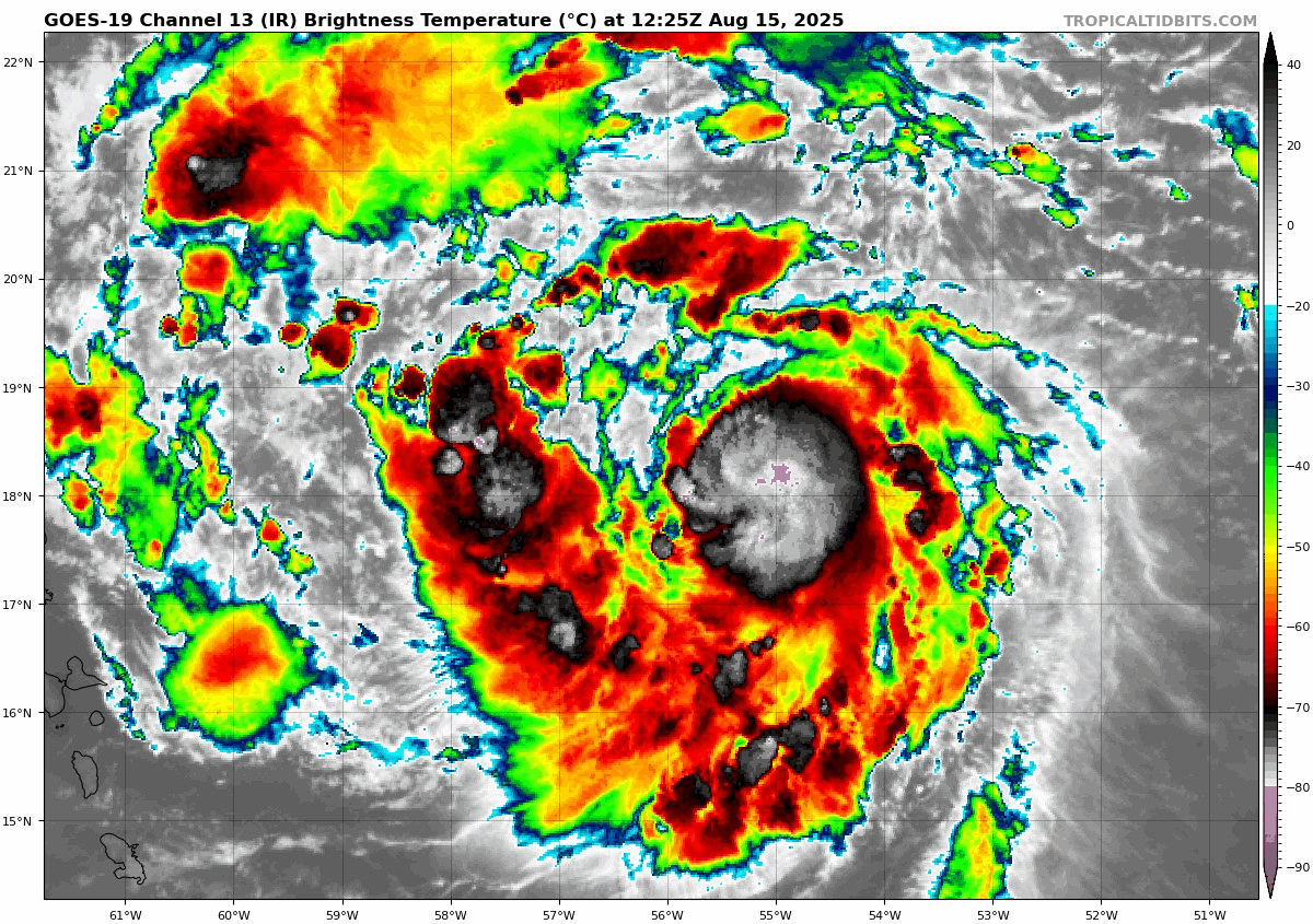
Hurricane Erin Satellite Loop
The 11 AM EDT Friday update documented winds at 75 mph. Hurricane Force Winds extend 25 miles from the center, and Tropical Storm Winds reach 115 miles from the center.
Update From The National Hurricane Center
- LOCATION…17.8N 54.4W
- ABOUT 570 MI…920 KM E OF THE NORTHERN LEEWARD ISLANDS
- MAXIMUM SUSTAINED WINDS…70 MPH…110 KM/H
- PRESENT MOVEMENT…WNW OR 285 DEGREES AT 17 MPH…28 KM/H
- MINIMUM CENTRAL PRESSURE…997 MB…29.44 INCHES
SUMMARY OF WATCHES AND WARNINGS IN EFFECT:
A Tropical Storm Watch is in effect for…
- Anguilla and Barbuda
- St. Martin and St. Barthelemy
- Saba and St. Eustatius
- Sint Maarten
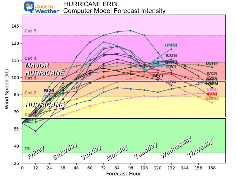
Forecast Intensity
It is now the first hurricane of the season in the Atlantic and is expected to become a Category 3 or higher Major Hurricane.
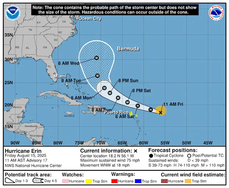
NHC Forecast Outlook…
Still expected to pass NORTH of the Caribbean Islands and East of the Bahamas AND West of Bermuda.
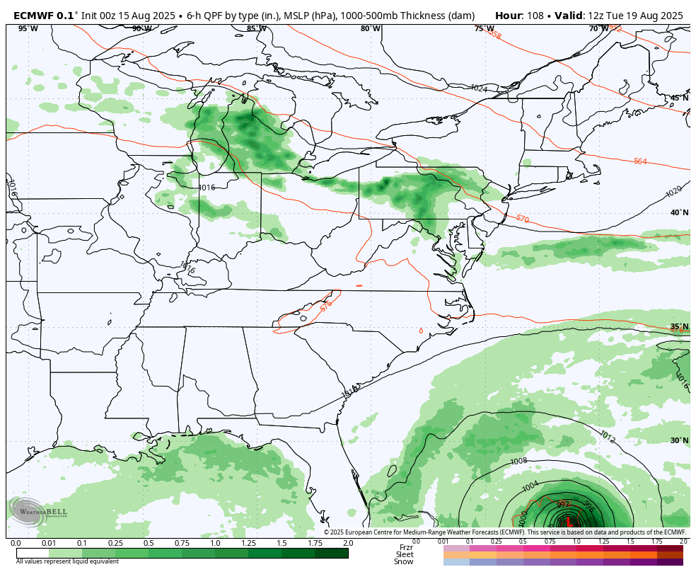
Tropical Models Forecast
ECMWF Model Animation:
Tuesday Aug 19 to Fri Aug 22
The typical curve is expected to pass well between the US and Bermuda.
The rain bands will affect the Northeast Caribbean Islands and maybe the Outer Banks (OBX) of North Carolina. A cold front approaching from the Ohio Valley and Great Lakes will bring rain to the Mid-Atlantic and keep Erin well offshore.
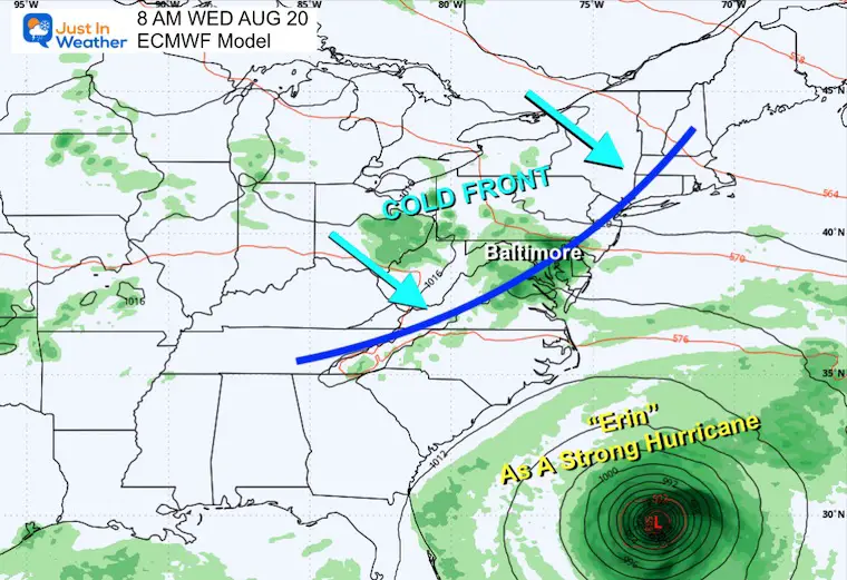
Snapshot Wednesday, August 20
A cold front heading across the Ohio Valley is expected to help keep the expected hurricane off the coast.
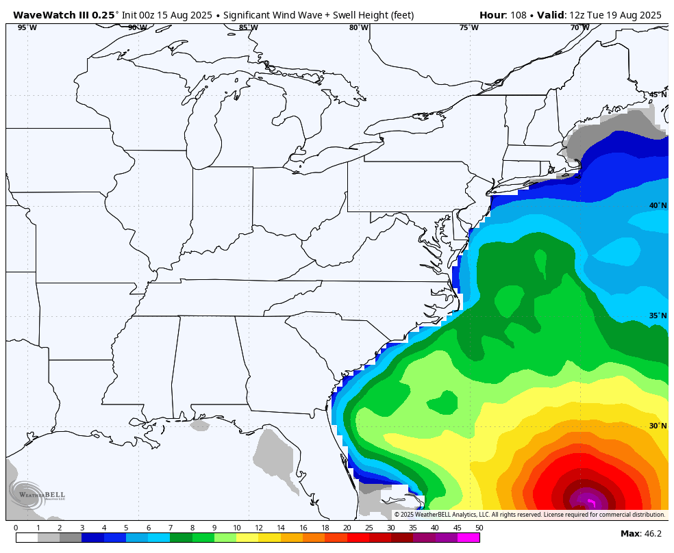
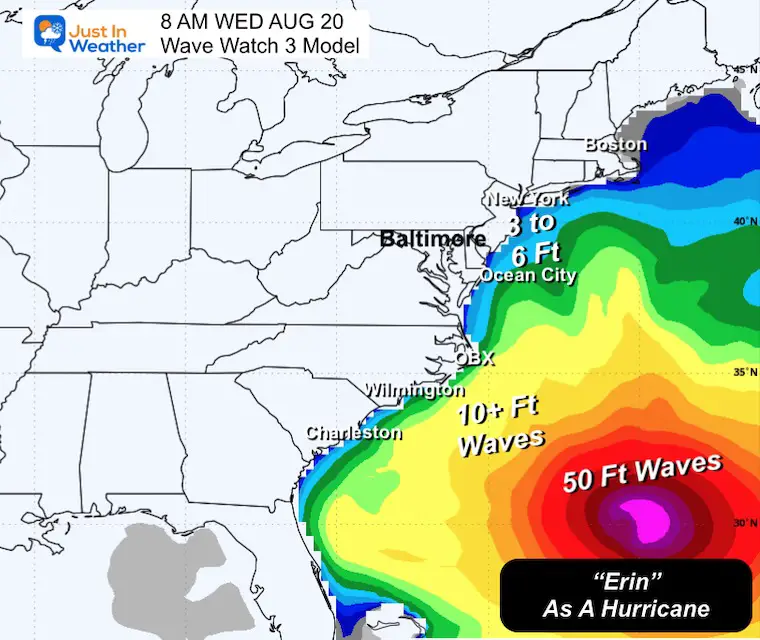
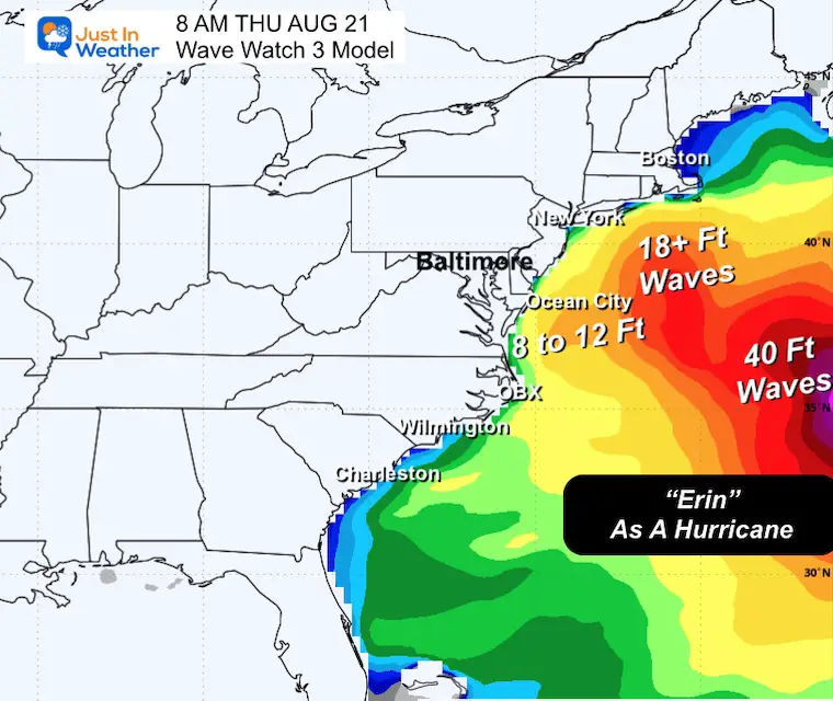
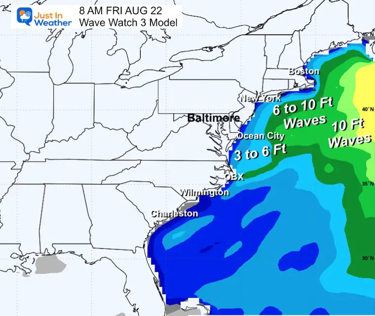
Wave Forecast East Coast
Tuesday To Friday
Waves 8 to 12 Feet across the Mid-Atlantic Coast.
Over 50 Foot waves near the center of the storm, well off the coast.
Snapshots
Wednesday
Thursday
Friday
Interactive Wind Forecast Widget
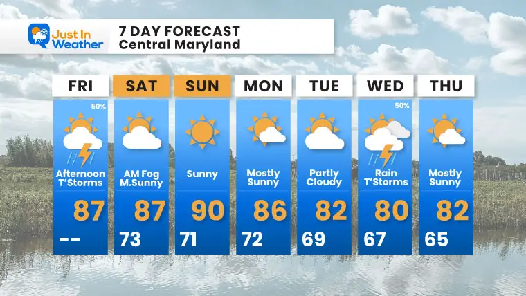
7 Day Forecast: Mid Atlantic/Metro Baltimore
- Today: Scattered T’Showers
- Weekend: Sunny, Less Humid
- Next Week: Storms Wednesday Push Erin Offshore
- Cooler Temps Will Follow
Subscribe for eMail Alerts
Please share your thoughts and best weather pics/videos, or just keep in touch via social media.
THANK YOU:
Baltimore Sun Magazine Readers Choice Best Of Baltimore
RESTATING MY MESSAGE ABOUT DYSLEXIA
I am aware there are some spelling and grammar typos and occasional other glitches. I take responsibility for my mistakes and even the computer glitches I may miss. I have made a few public statements over the years, but if you are new here, you may have missed it: I have dyslexia and found out during my second year at Cornell University. It didn’t stop me from getting my meteorology degree and being the first to get the AMS CBM in the Baltimore/Washington region. One of my professors told me that I had made it that far without knowing and to not let it be a crutch going forward. That was Mark Wysocki, and he was absolutely correct! I do miss my mistakes in my own proofreading. The autocorrect spell check on my computer sometimes does an injustice to make it worse. I also can make mistakes in forecasting. No one is perfect at predicting the future. All of the maps and information are accurate. The ‘wordy’ stuff can get sticky. There has been no editor who can check my work while writing and to have it ready to send out in a newsworthy timeline. Barbara Werner is a member of the web team that helps me maintain this site. She has taken it upon herself to edit typos when she is available. That could be AFTER you read this. I accept this and perhaps proves what you read is really from me… It’s part of my charm. #FITF


