


Winter Weather Advisory Sunday As Snowfall In Two Parts Affecting Two Different Areas
Saturday Evening Update January 17 2026 One thing I carry after all of my years of forecasting: If one model does a really good job in an active pattern, then…
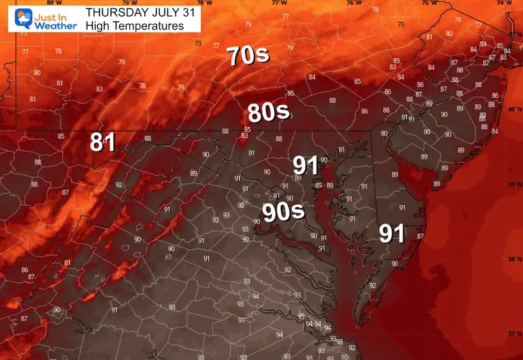
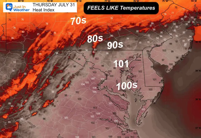
Thursday, July 31 2025
Morning Report
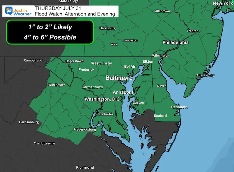
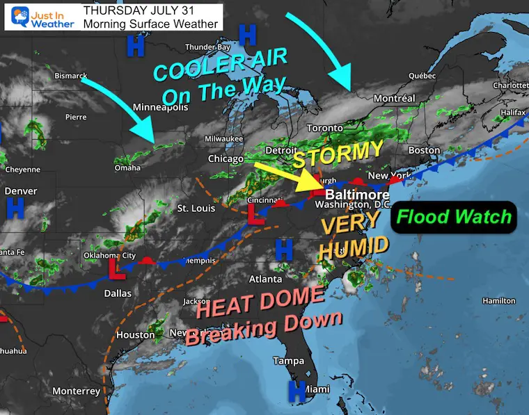
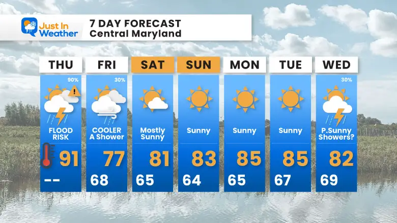
Today is the end of the heat wave, and the force that will break it will be powerful. There is so much humidity in the air, along with the high heat, that thunderstorms will have a high water capacity. This means torrential downpours could lead to urban flooding and swollen streams.
A few inches of rain could fall in less than one hour in spots.
TURN AROUND—DON’T DROWN: If roads are flooded, it is best not to try to cross them. Water 6 to 10 inches deep can move a car and an SUV.
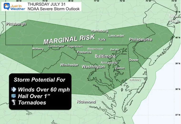
The risk for a severe storm is Marginal, but still a potential that damaging winds and even a tornado are possible.
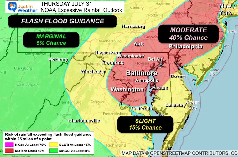
There is a Marginal Risk that storms will contain large hail and even a tornado. This risk is ‘LOW’ but still worth watching.
A Severe Storm Watch may be issued for the region this afternoon and evening.
A WARNING will be issued when storms are identified, and the towns in the path will be listed. These usually last 45 minutes, while Flood Warnings may last many hours.
The clash of our very humid air with the arrival of a new cooler air mass is along a boundary that is nearly stationary this morning. It will take all day to move through our region… The focal point for widespread thunderstorms. The slow movement and high moisture content are why we expect flooding.
The new air mass will expand our way tomorrow through the weekend.
This will begin to get active by Noon
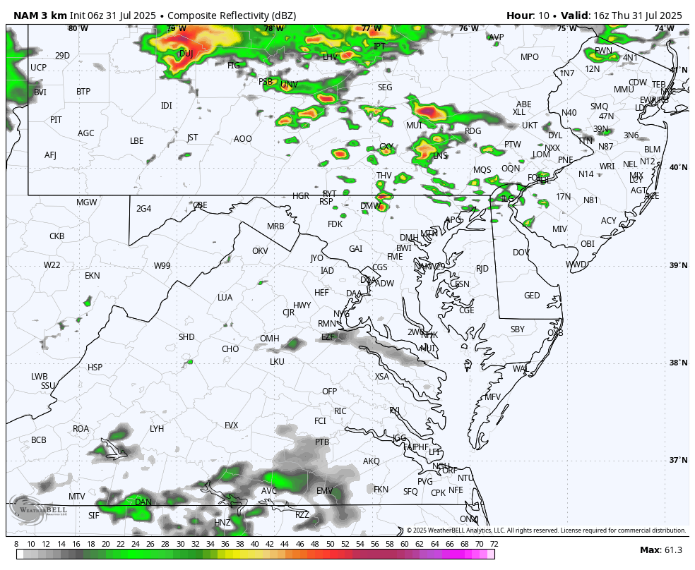
Includes Automated Updates For Severe Storms, Radar, and Tropics

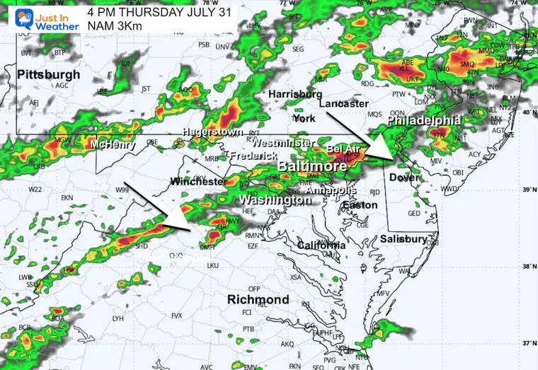
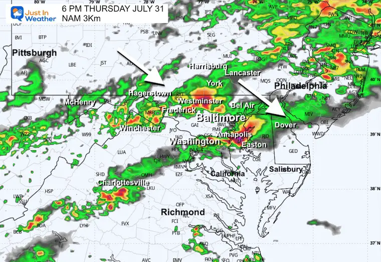
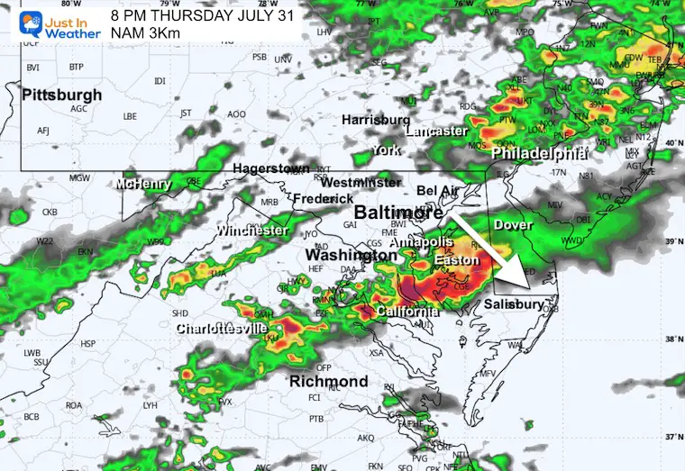
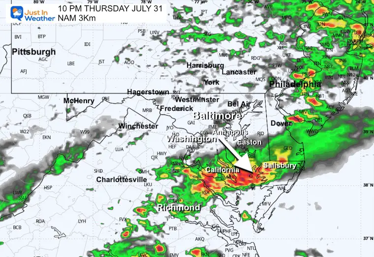
There are different timelines spread across the short-range models. Here is a sample of two:
These are SUGGESTIONS – NOT A PROMISE
Noon To Midnight
This starts the flare-up early afternoon, then brings the cold front through Central Maryland around sunset and to the beaches tonight.
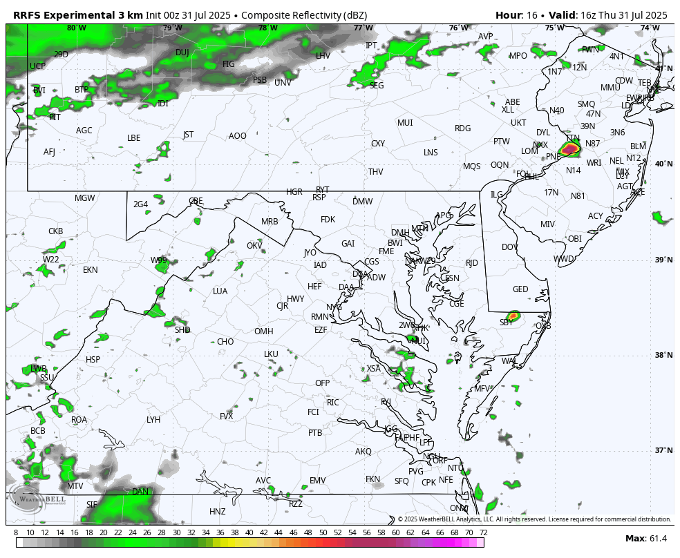
Also starts the showers close to 12 PM/Noon.
This solution shifts the main energy farther south, earlier.
Yesterday: Low 75F; High 94F
Rainfall = 0.00”
Days 90F Or Above = 223
Sunrise at 6:06 AM
Sunset at 8:19 PM
Normal Low in Baltimore: 68ºF
Record 54ºF in 1954
Normal High in Baltimore: 88ºF
Record 102ºF 1956; 1997
Rainfall Deficit at BWI
Subscribe for eMail Alerts
Sign up and be the first to know!
Our week-long, 329-mile hike and bike across the state to honor kids and families in Just In Power Kids, fighting Childhood Cancer.
Click to see more


Sign up and be the first to know!
The annual event: Hiking and biking 329 miles in 7 days between The Summit of Wisp to Ocean City.
Each day, we honor a kid and their family’s cancer journey.
Fundraising is for Just In Power Kids: Funding Free Holistic Programs. I never have and never will take a penny. It is all for our nonprofit to operate.
Click here or the image to donate:

I am aware there are some spelling and grammar typos and occasional other glitches. I take responsibility for my mistakes and even the computer glitches I may miss. I have made a few public statements over the years, but if you are new here, you may have missed it: I have dyslexia and found out during my second year at Cornell University. It didn’t stop me from getting my meteorology degree and being the first to get the AMS CBM in the Baltimore/Washington region. One of my professors told me that I had made it that far without knowing and to not let it be a crutch going forward. That was Mark Wysocki, and he was absolutely correct! I do miss my mistakes in my own proofreading. The autocorrect spell check on my computer sometimes does an injustice to make it worse. I also can make mistakes in forecasting. No one is perfect at predicting the future. All of the maps and information are accurate. The ‘wordy’ stuff can get sticky. There has been no editor who can check my work while writing and to have it ready to send out in a newsworthy timeline. Barbara Werner is a member of the web team that helps me maintain this site. She has taken it upon herself to edit typos when she is available. That could be AFTER you read this. I accept this and perhaps proves what you read is really from me… It’s part of my charm. #FITF