


Winter Weather Advisory Sunday As Snowfall In Two Parts Affecting Two Different Areas
Saturday Evening Update January 17 2026 One thing I carry after all of my years of forecasting: If one model does a really good job in an active pattern, then…
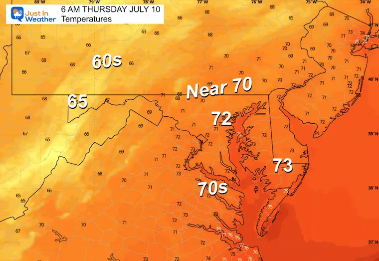
Wednesday Afternoon
July 9 2024
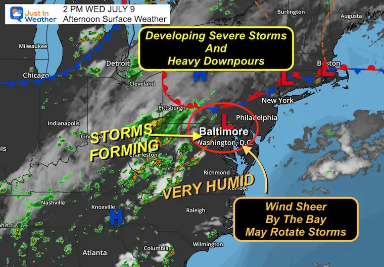
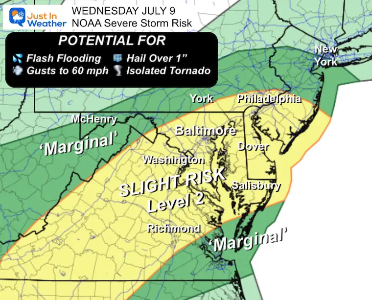
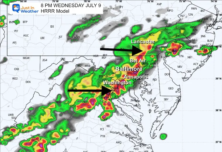
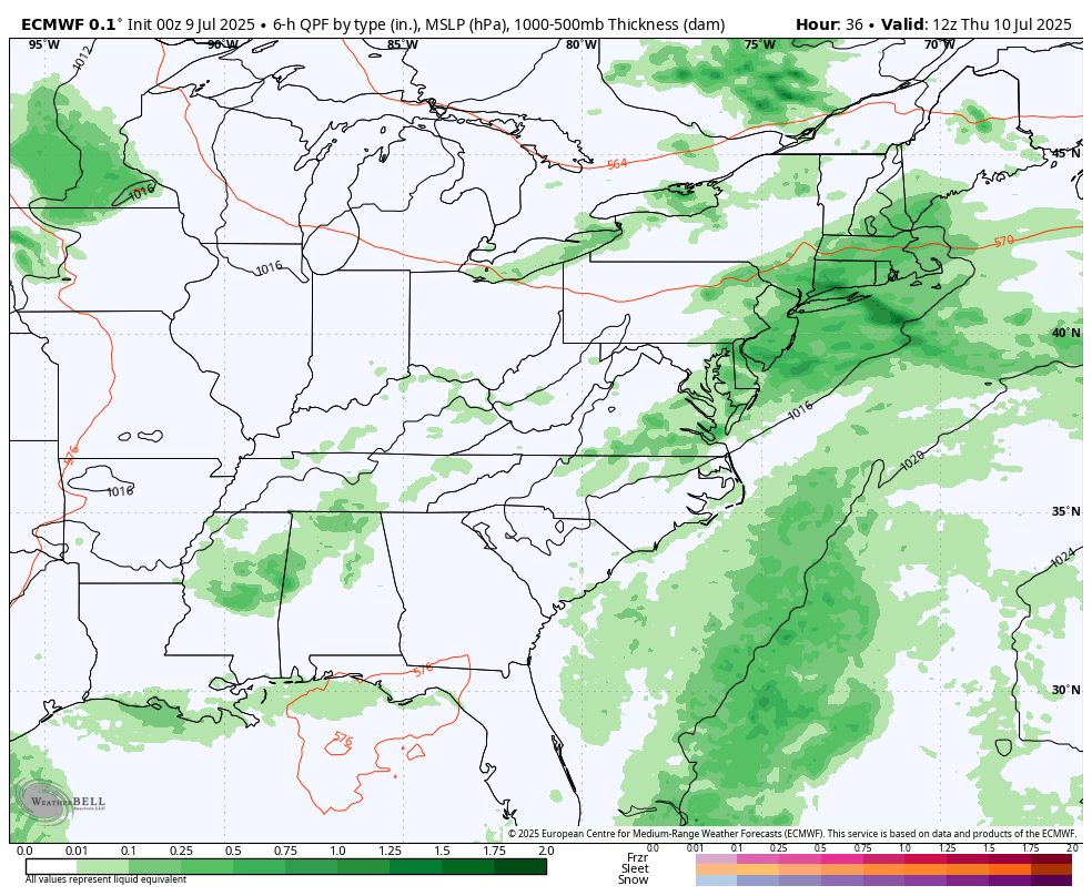
The atmosphere is still very juicy! Dew points are high in the mid-70s, which means there is a lot of moisture in the atmosphere to work with. Additional factors, such as a nearly stalled frontal boundary, can instigate thunderstorm formation. Plus, we have a meso-low pressure with a trough that has helped a Bay Breeze develop. This wind FROM the East will play a role in helping build storms that are expected to turn severe.
I have included the LIVE Radar and Lightning Widget in this report. It is important to note that any storm, even without a warning, can produce dangerous lightning and torrential downpours.
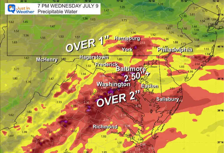
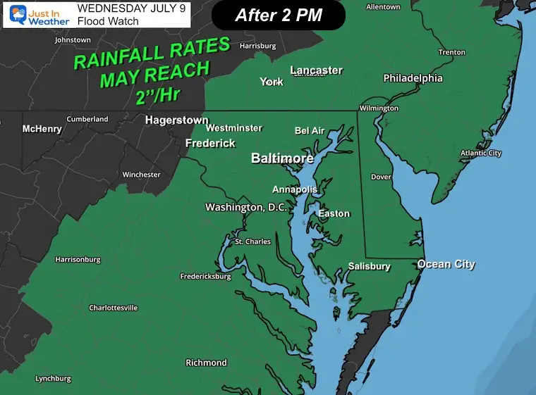
The main concern is that rainfall rates may reach 2 to 3 inches per hour.
Heavy rain will continue this evening into southern Maryland and across the Chesapeake Bay to Delmarva, but the severe limits are expected to be reduced after dark.
The Bay Breeze is onshore, helping to push more moisture in. It can interact with different wind directions inland and aloft to produce wind sheer. This can get storms to rotate, allowing them to grow taller. These will help produce heavy rainfall, in addition to possibly large hail and some tornadoes. I know that is standard language with a severe thunderstorm risk, but the parameters today are at a rare high level for our region.
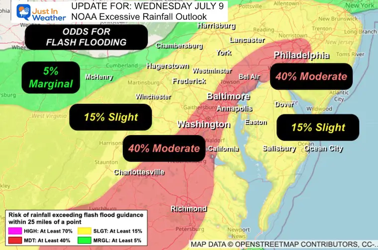
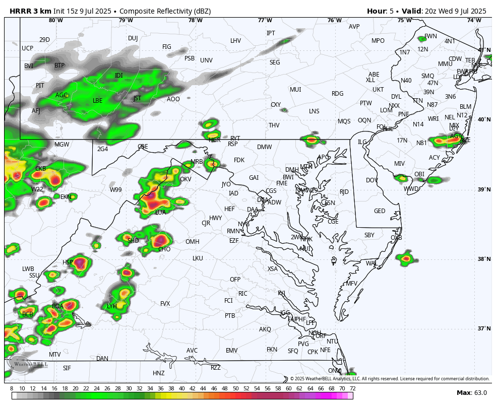
Flash Flood Guidance
This is a snapshot at 7 PM, with the potential to drop over 2 inches of rain in the area of storms entering metro Washington and Baltimore.
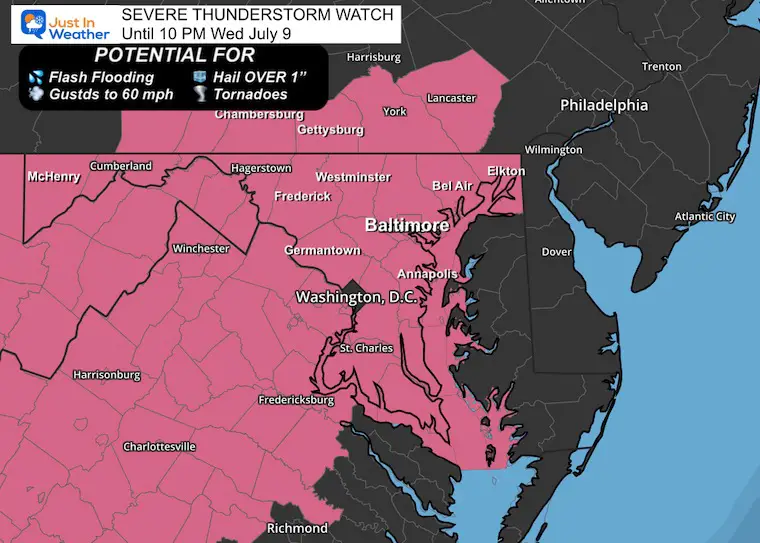
A chance for a thundershower to grow to severe levels, which may include:
Any storm may contain dangerous lightning and local flash flooding.
A WARNING will be issued when storms are identified, and track specific towns in the path will be listed. These usually last 45 minutes, while Flood Warnings may last many hours.
Like yesterday, a line of strong to severe storms will move through metro Baltimore and the other I-95 cities/suburbs, then shift the heavy rain to Southern Maryland and Delmarva later this evening and tonight.
The timing will not be the same as yesterday, nor will the same exact locations be promised to get hit or miss. But overall, it will impact across the region.
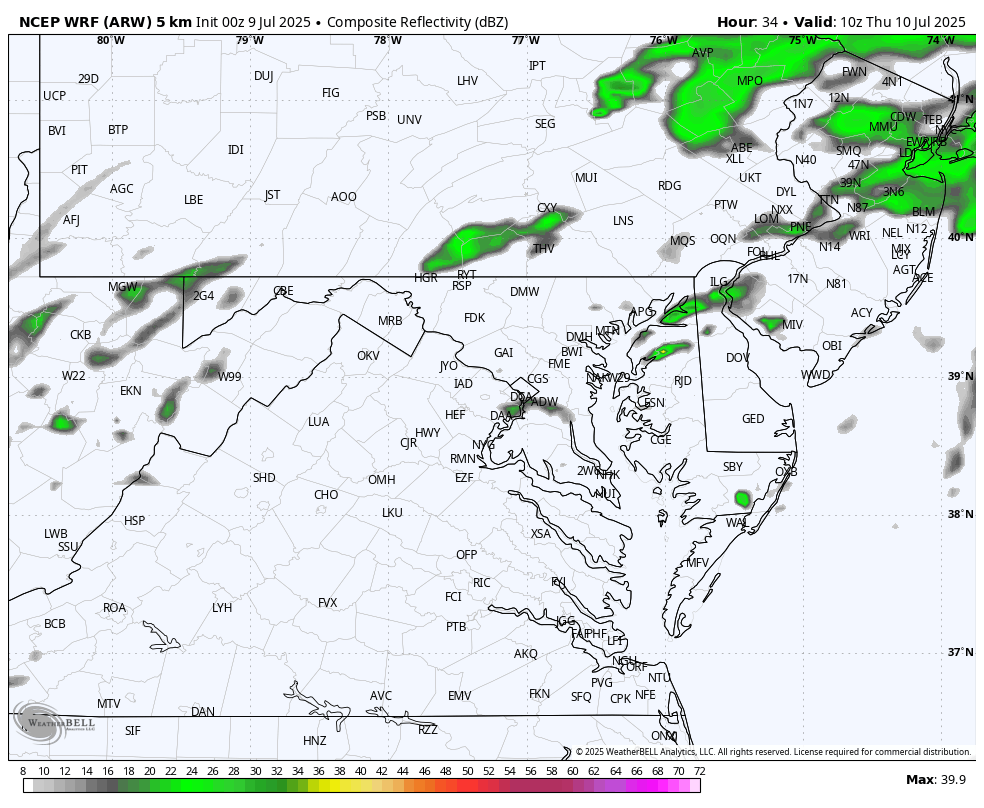
This simulation is a suggestion and not a promise. Use this as a rough guide for the timeline.
The HRRR Model suggests that there may be rotation in cells ahead or along the line between 6 PM and 8 PM in the metro Baltimore and Washington, D.C. area.
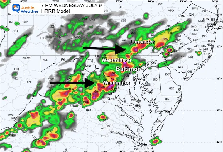
‘SUGGESTION’ Not A Promise
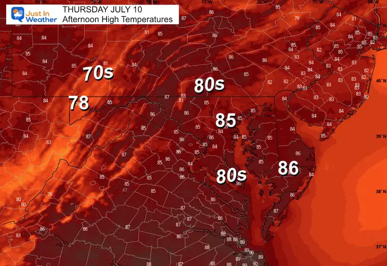
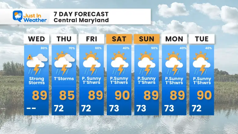
More lines of heavy showers and thunderstorms are expected in the afternoon and evening.
Daily thundershowers in the afternoons and evenings, the rest of the week.
Daily showers and thunderstorms are likely.
Sign up and be the first to know!
The annual event: Hiking and biking 329 miles in 7 days between The Summit of Wisp to Ocean City.
Each day, we honor a kid and their family’s cancer journey.
Fundraising is for Just In Power Kids: Funding Free Holistic Programs. I never have and never will take a penny. It is all for our nonprofit to operate.
Click here or the image to donate:

I am aware there are some spelling and grammar typos and occasional other glitches. I take responsibility for my mistakes and even the computer glitches I may miss. I have made a few public statements over the years, but if you are new here, you may have missed it: I have dyslexia and found out during my second year at Cornell University. It didn’t stop me from getting my meteorology degree and being the first to get the AMS CBM in the Baltimore/Washington region. One of my professors told me that I had made it that far without knowing and to not let it be a crutch going forward. That was Mark Wysocki, and he was absolutely correct! I do miss my mistakes in my own proofreading. The autocorrect spell check on my computer sometimes does an injustice to make it worse. I also can make mistakes in forecasting. No one is perfect at predicting the future. All of the maps and information are accurate. The ‘wordy’ stuff can get sticky. There has been no editor who can check my work while writing and to have it ready to send out in a newsworthy timeline. Barbara Werner is a member of the web team that helps me maintain this site. She has taken it upon herself to edit typos when she is available. That could be AFTER you read this. I accept this and perhaps proves what you read is really from me… It’s part of my charm. #FITF