Sunday, June 22 2025
We are about to begin our first heat wave of the year. In Baltimore, we just had our second 90-degree day of the year yesterday, while also having two days in the 60s this month. So, most are not acclimated to the hot air.
Ironically, the record high for this date was set last year at 101℉.
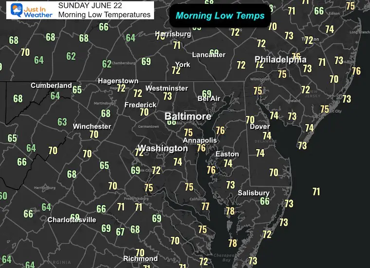
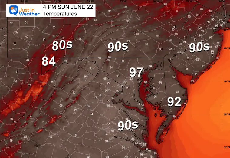
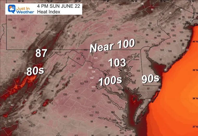
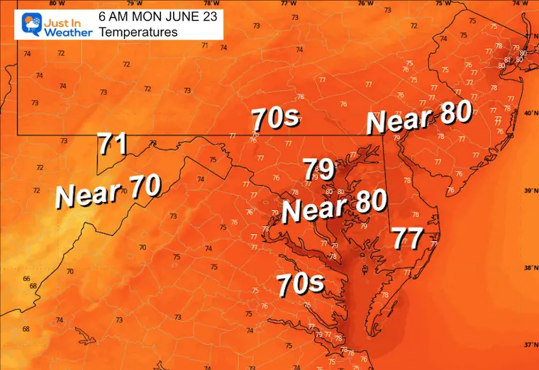
Today, we surge into the upper 90s, but an increase in humidity will follow, making it feel unbearable. The result will be afternoon heat index values over 105℉. In addition, the morning low temperatures will remain in the mid-70s, while cities may remain in the 80s. This limits any relief through the middle of the week.
It will break down by Thursday and Friday.
There are many records that may be broken across our region, both with afternoon highs and morning (warm) lows.
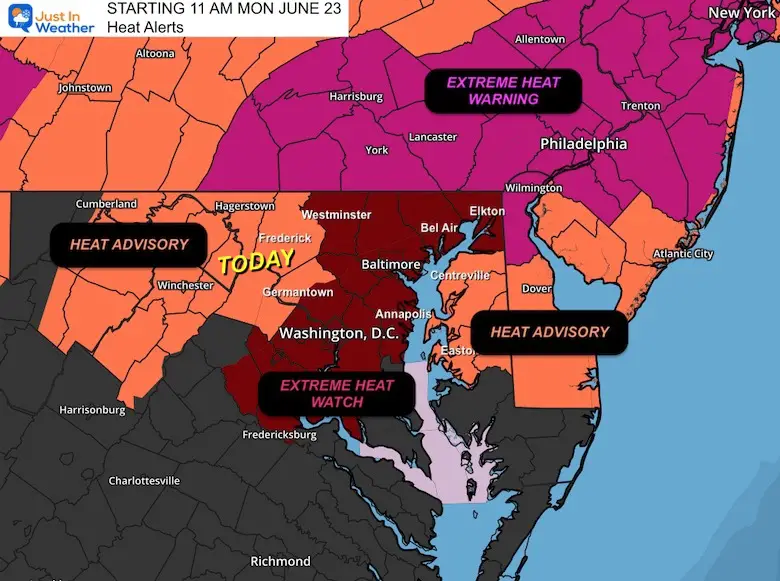
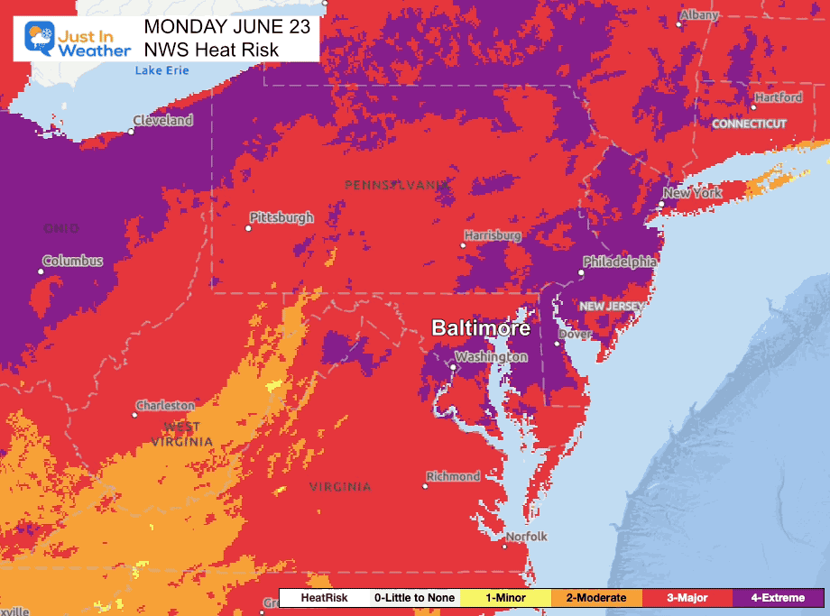
Heat Alerts
TODAY:
Heat Advisory Frederick and Montgomery Co in MD
Heat Index up to 105℉
Beginning Monday
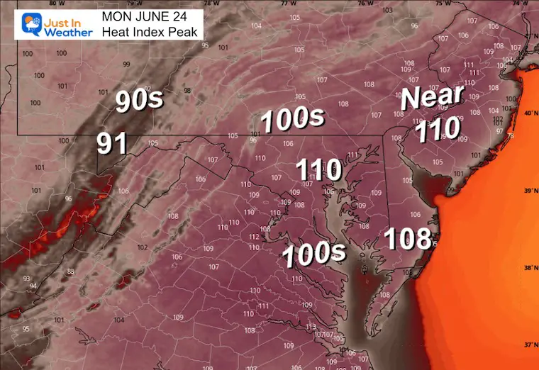
Extreme Heat Watch: Heat Index Up to 110℉
Extreme Heat Warning in PA: Essentially the same thing!
Please Consider:
Children: CHECK THE BACKSEAT OF YOUR CAR! DO NOT LEAVE A KID IN THE CAR!
Pets: The pavement will be HOT as well, and paws can burn. Limit the outside time for your furry friends to early morning or evening.
DO NOT leave pets in cars. Temperatures can jump more than 40 degrees hotter inside within minutes, even with the window open. Leaving a vehicle unattended with the AC on can cause it to stall or be driven away by someone else.
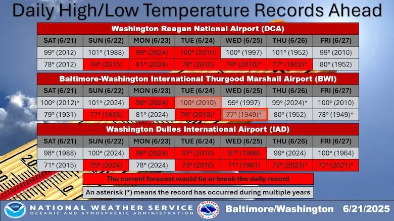
BROKEN RECORD TEMPERATURES?
Focus on Baltimore’s BWI both warmest mornings and afternoon/daily highs.
The Washington Airports (official weather stations) may break more.
Potential Records To Be Tied or Broken In Baltimore
- Sunday WARMEST Low: 77℉ in 1933
- Monday High 98℉ in 2024
- Tuesday Low 76℉ in 2010
- Tuesday High 100℉ in 2010
- Wednesday Low 77℉ in 1948
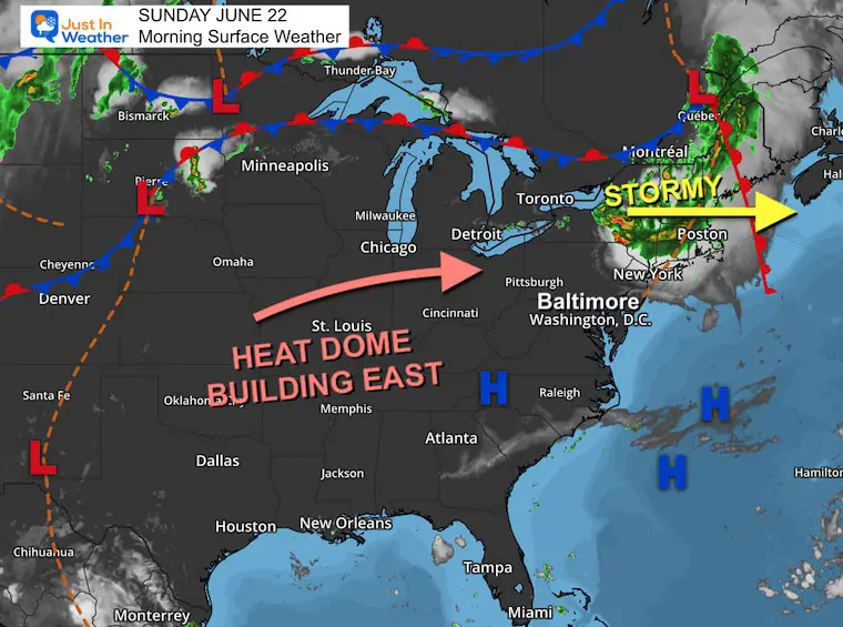
TODAY’S Weather
Morning Temperatures at 6 AM
Morning Surface Weather
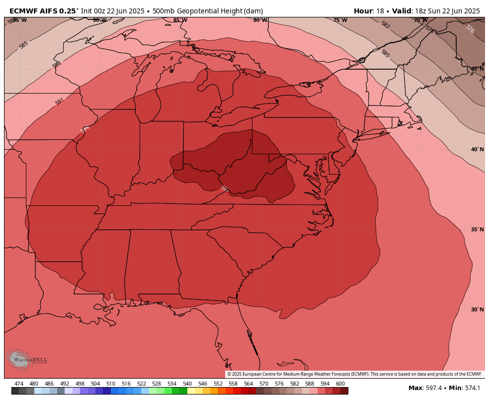
High Pressure is the main event setting up this Heat Dome for the next few days. This stable air mass is hot and dry, however the humidity will be pumping in from the southwest.
To our north, another mesoscale convective complex produced a large cluster of severe storms passing through Northern New York and New England. That will miss us and, and after moving out into the Atlantic, will allow that region to get in on the heat as well.
Jet Steam Forecast Sunday Afternoon To Thursday Afternoon
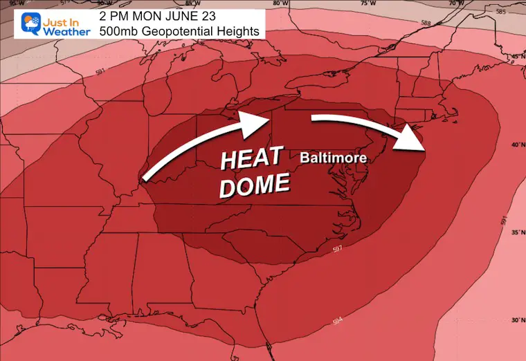
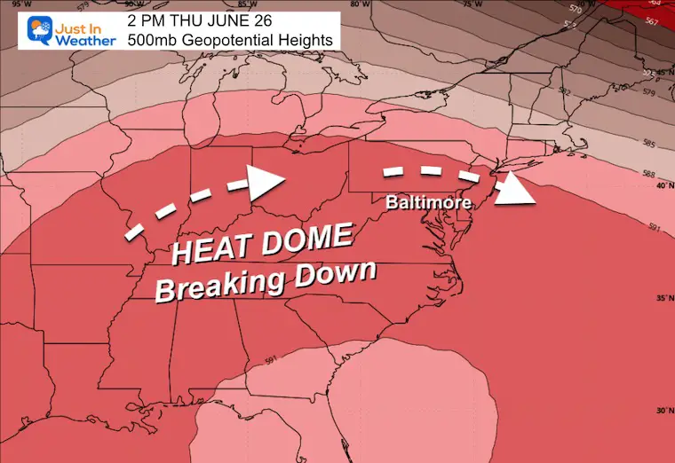
The heat dome will be strongest over our region for the first half of the week. It will break down a little on Thursday and Friday.
Snapshot Monday
Snapshot Thursday
Live Satellite Widget
FORECAST: High Temperatures Afternoon
Heat Index: Afternoon
Subscribe for eMail Alerts
CLIMATE DATA: Baltimore
TODAY June 22
Sunrise at 5:41 AM
Sunset at 8:37 PM
Normal Low in Baltimore: 65ºF
Record 46ºF in 1992
Normal High in Baltimore: 87ºF
Record 101ºF 2024
Rainfall Deficit at BWI
- Ending 2024 = -8.00”
- Since Jan 1 = -1.59”
- We are STILL DOWN -9.59” INCLUDING LAST YEAR
MONDAY
Morning Low Temperatures
Afternoon High Temperatures

Heat Index
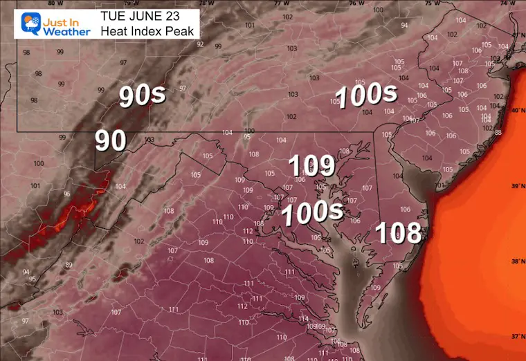
TUESDAY
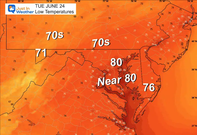
Morning Low Temperatures
Afternoon High Temperatures
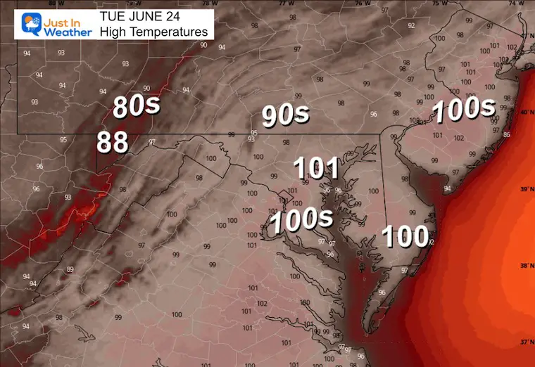
Heat Index
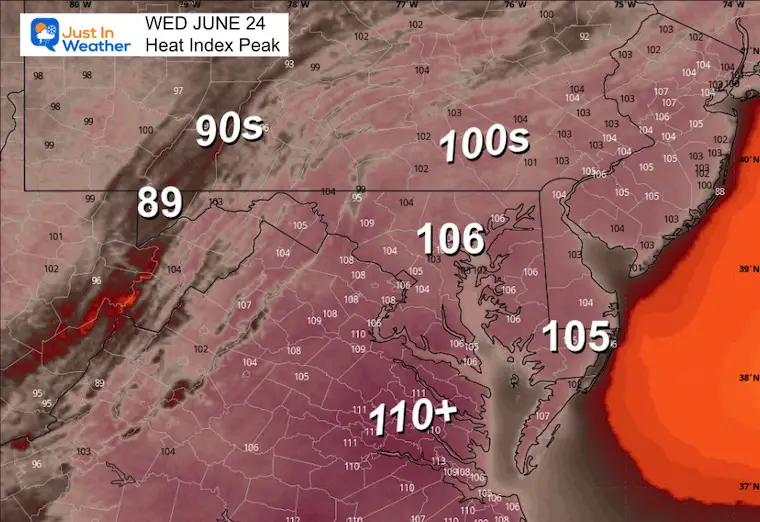
WEDNESDAY
Afternoon High Temperatures
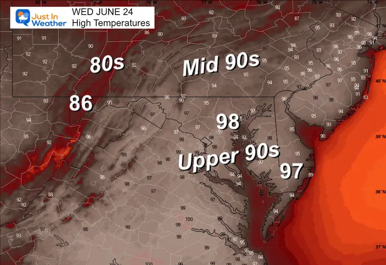
Heat Index
LOOKING AHEAD
NWS Heat Risk: Monday to Friday
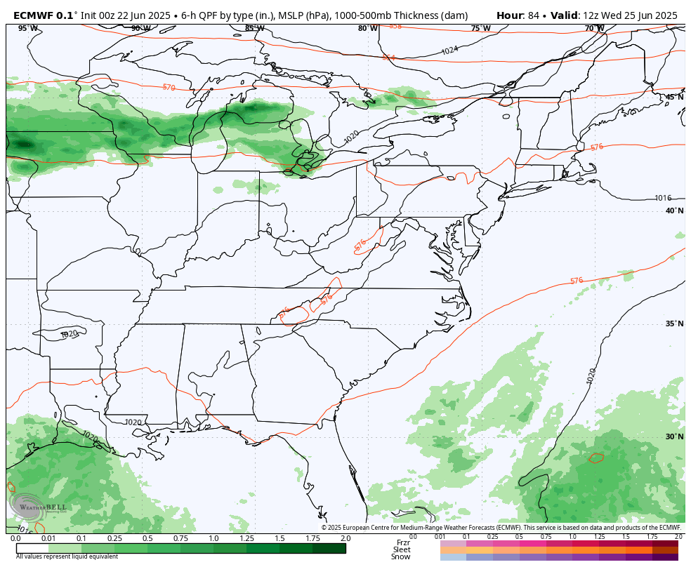
Storm Forecast Wednesday Afternoon to Saturday Afternoon
The potential for daily thunderstorms will increase each afternoon and evening.
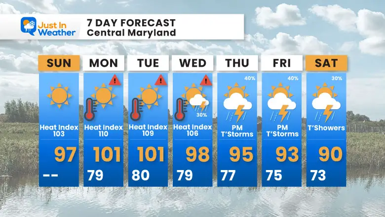
7 Day Forecast
- Today: Upper 90s
- Money to Wednesday: Heat Index OVER 105℉
- Wednesday may bring some thundershowers.
- Thu and Fri: Scattered STRONG Afternoon T’Storms; Less Intense Heat
Subscribe for eMail Alerts
Please share your thoughts and best weather pics/videos, or just keep in touch via social media.
THANK YOU:
Baltimore Sun Magazine Readers Choice Best Of Baltimore
Maryland Trek 11 Day 7 Completed Sat August 10
We raised OVER $111,000 for Just In Power Kids – AND Still Collecting More
The annual event: Hiking and biking 329 miles in 7 days between The Summit of Wisp to Ocean City.
Each day, we honor a kid and their family’s cancer journey.
Fundraising is for Just In Power Kids: Funding Free Holistic Programs. I never have and never will take a penny. It is all for our nonprofit to operate.
Click here or the image to donate:

RESTATING MY MESSAGE ABOUT DYSLEXIA
I am aware there are some spelling and grammar typos and occasional other glitches. I take responsibility for my mistakes and even the computer glitches I may miss. I have made a few public statements over the years, but if you are new here, you may have missed it: I have dyslexia and found out during my second year at Cornell University. It didn’t stop me from getting my meteorology degree and being the first to get the AMS CBM in the Baltimore/Washington region. One of my professors told me that I had made it that far without knowing and to not let it be a crutch going forward. That was Mark Wysocki, and he was absolutely correct! I do miss my mistakes in my own proofreading. The autocorrect spell check on my computer sometimes does an injustice to make it worse. I also can make mistakes in forecasting. No one is perfect at predicting the future. All of the maps and information are accurate. The ‘wordy’ stuff can get sticky. There has been no editor who can check my work while writing and to have it ready to send out in a newsworthy timeline. Barbara Werner is a member of the web team that helps me maintain this site. She has taken it upon herself to edit typos when she is available. That could be AFTER you read this. I accept this and perhaps proves what you read is really from me… It’s part of my charm. #FITF


