Wednesday, June 18, 2025
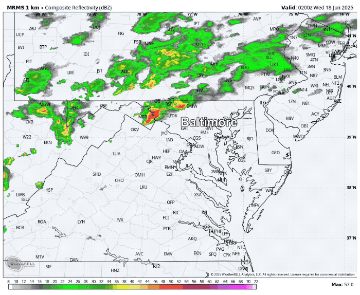
A round of thunderstorms passed through North Central Maryland and Southern Pennsylvania overnight. This marked the warm front finally pushing through and it will be noticeable this morning for sure!
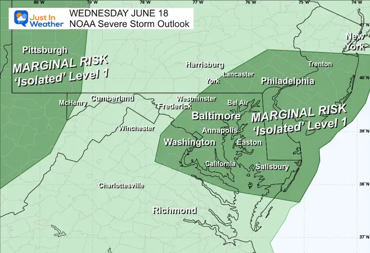
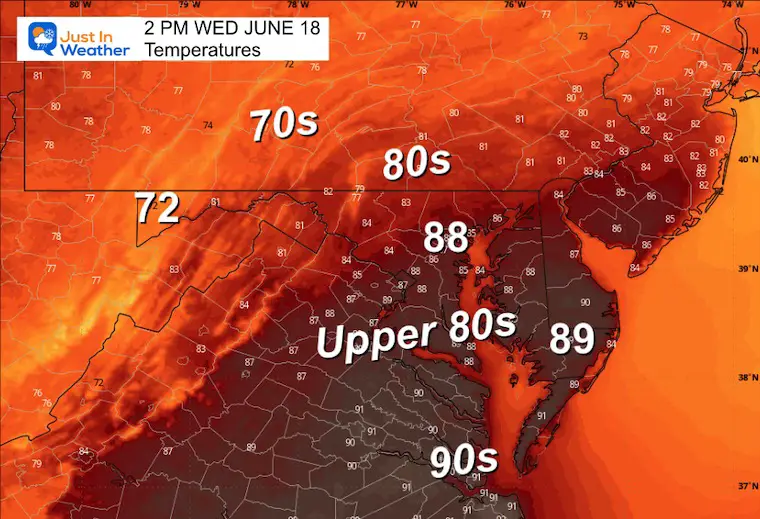
This sticky air will allow the next round of thunderstorms to cross our region this afternoon, with a marginal risk that they will turn severe.
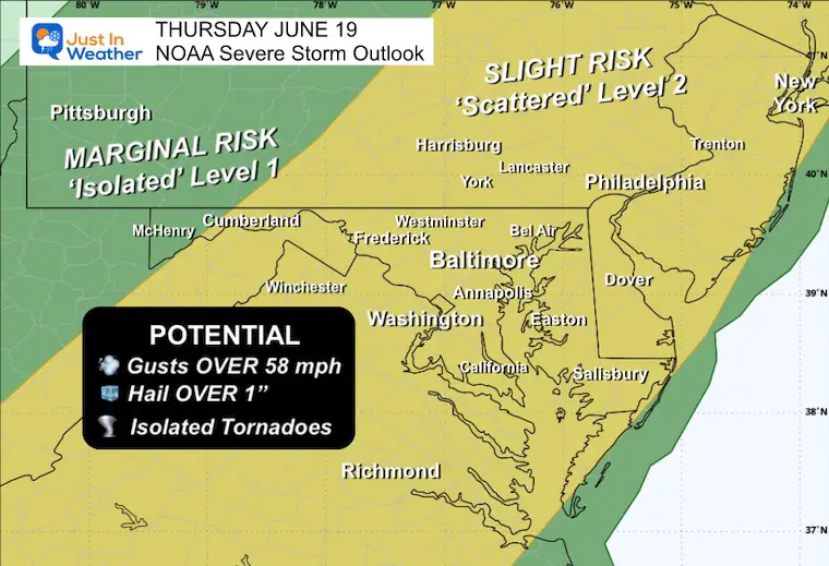
This risk will increase on Thursday!
Friday is the Summer Solstice, and it will feel like it this weekend.
Next Week: A Dangerous Heat Wave will be building.
Headlines
- Morning: Noticeably warmer and more humid! Areas of Thick Fog
- Afternoon: Storms reach into Central Maryland
- Thursday: NOAA Severe Storm Risk INCREASES
- Heat Wave Begins This Weekend Into Next Week
Morning Set Up
Radar Recap 10 PM Tue to 6 AM Wed
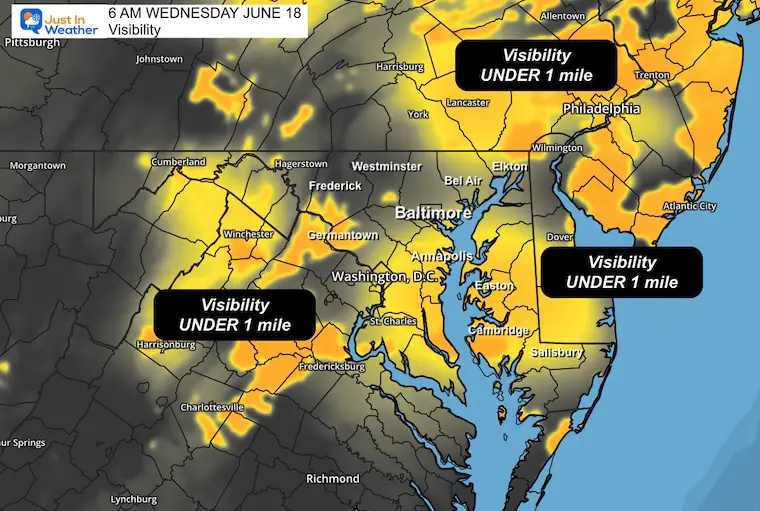
Visibility at 6 AM
Live Radar and Lightning Widget
Drizzle and Fog will not show well on here. That may be deceiving today.
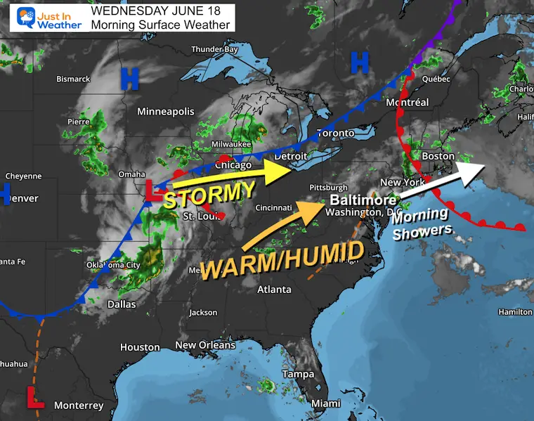
Morning Surface Weather
The warm front has finally pushed through, and you may feel it immediately out the door.
Higher temps AND more humidity will feed into a better chance for thunderstorms to cross into our region today.
The next wave of Low Pressure will ignite a higher risk for severe storms in the Mid-Atlantic tomorrow.
NOAA Severe Storm Risk
Wednesday
Thursday
TODAY:
High Temperatures
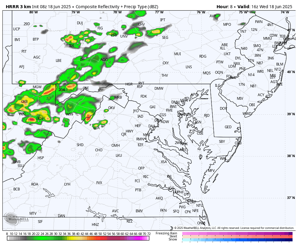
Forecast Radar Simulation
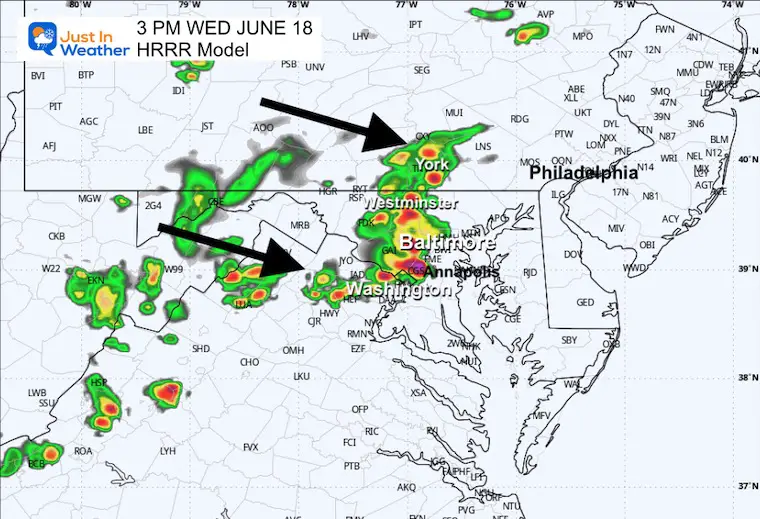
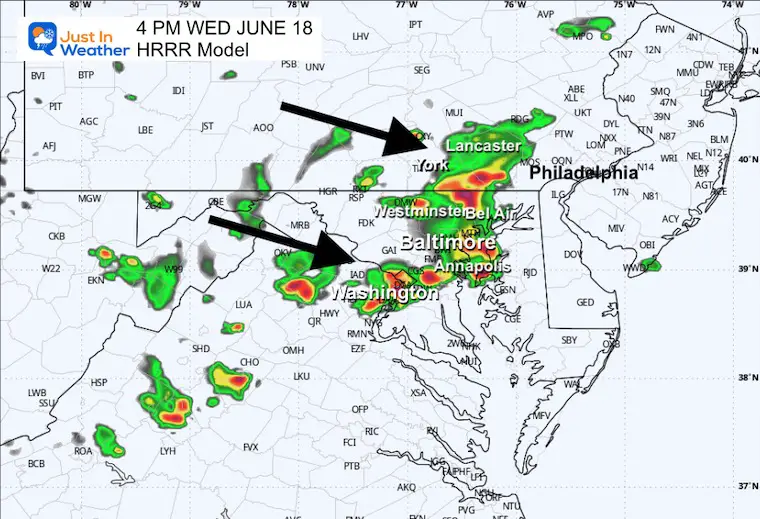
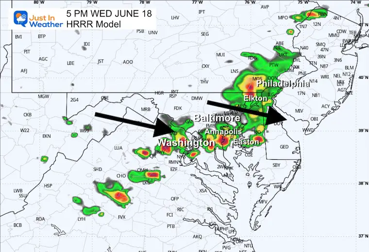
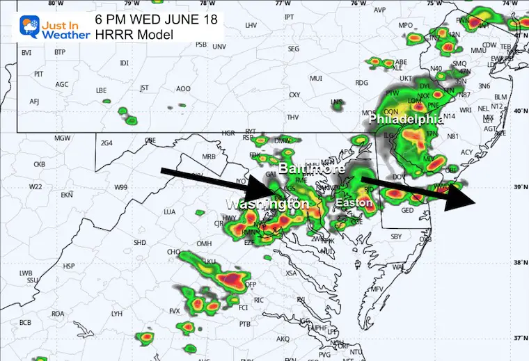
HRRR Model Noon to 10 PM
Developing Thundershowers will form in the mountains… then are expected to affect our western and northern suburbs in the evening.
A better chance these cross into Central Maryland.
SUGGESTED TIMELINE: NOT A PROMISE
Snapshots
3 PM
4 PM
5 PM
6 PM
Subscribe for eMail Alerts
CLIMATE DATA: Baltimore
TODAY June 18
Sunrise at 5:40 AM
Sunset at 8:36 PM
Normal Low in Baltimore: 64ºF
Record 48ºF in 1959
Normal High in Baltimore: 85ºF
Record 97ºF 1944; 1957
Rainfall Deficit at BWI
Ending 2024 = -8.00”
Since Jan 1 = -2.23”
We are STILL DOWN -10.23” INCLUDING LAST YEAR
Maryland Trek 12 August 3 to 9
This is an annual event: Hiking and biking 329 miles in 7 days between the Summit of Wisp to Ocean City.
Here are the kids we will honor each day as we cross Maryland.
Our full week team is set. We have our Day 4 all-bike ride open for registration.

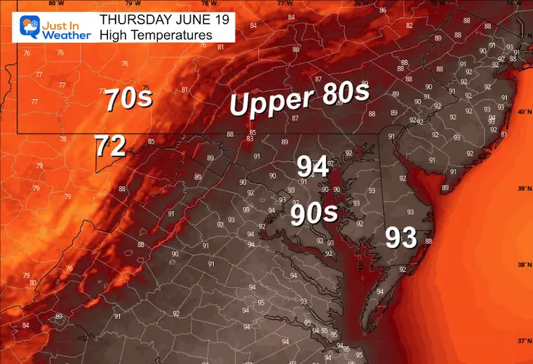
Thursday
Morning Low Temperatures
Afternoon High Temperatures
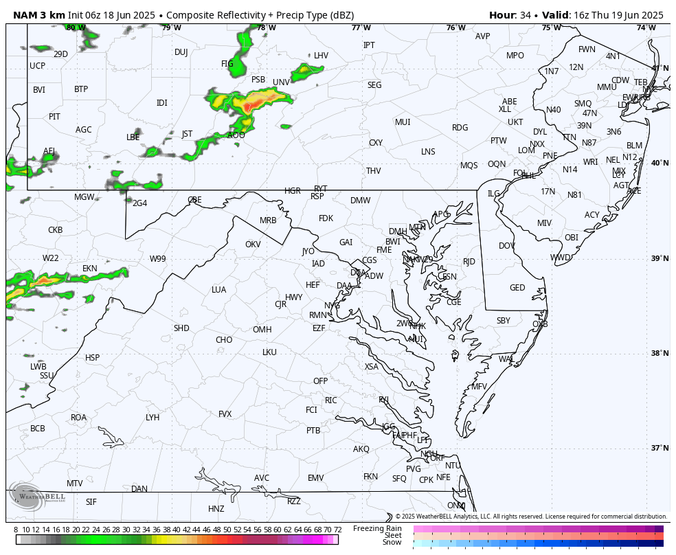
Radar Simulation Noon to Midnight
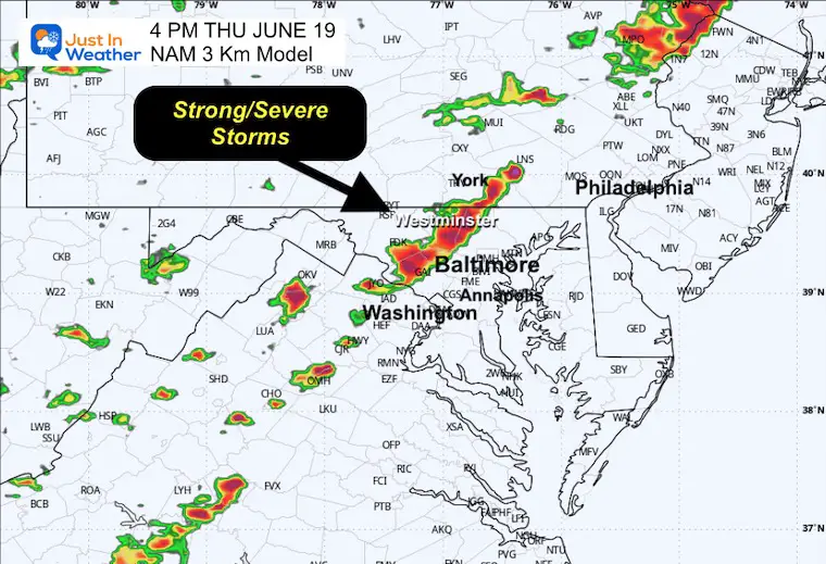
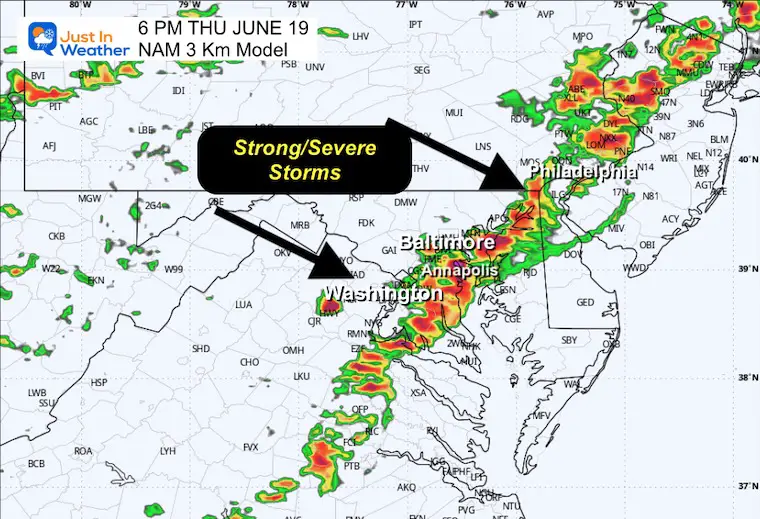
A line of strong storms is expected, with numerous cells capable of producing damaging winds or more severe conditions.
SUGGESTED TIMELINE: NOT A PROMISE
4 PM Snapshot
6 PM Snapshot
LOOKING AHEAD
I posted this last night… Here is the look from the ECMWF Model. It is not the final word, but definitely pushing the worst of the heat!
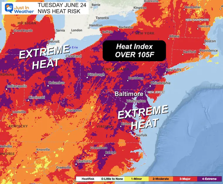
Tuesday Extreme Heat Risk
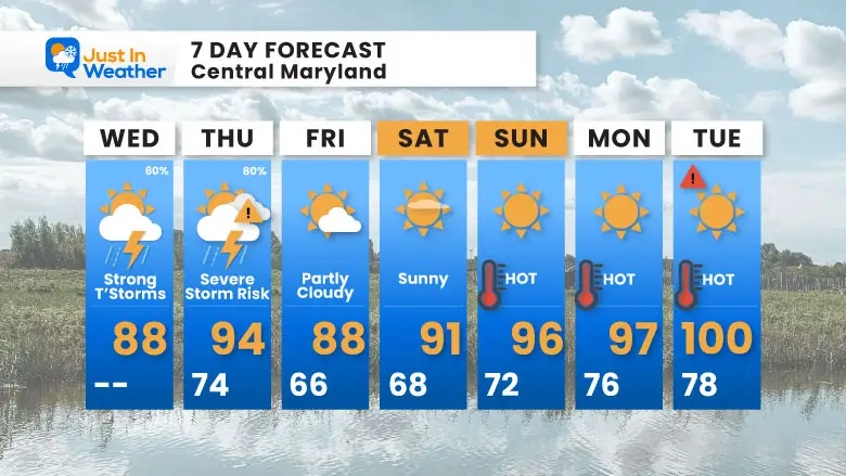
7 Day Forecast
- Severe Storm Risk Today And Thursday
- Weekend: Hot and Dry
- Next Week: Dangerous Heat
Subscribe for eMail Alerts
Please share your thoughts and best weather pics/videos, or just keep in touch via social media.
THANK YOU:
Baltimore Sun Magazine Readers Choice Best Of Baltimore
Maryland Trek 11 Day 7 Completed Sat August 10
We raised OVER $111,000 for Just In Power Kids – AND Still Collecting More
The annual event: Hiking and biking 329 miles in 7 days between The Summit of Wisp to Ocean City.
Each day, we honor a kid and their family’s cancer journey.
Fundraising is for Just In Power Kids: Funding Free Holistic Programs. I never have and never will take a penny. It is all for our nonprofit to operate.
Click here or the image to donate:

RESTATING MY MESSAGE ABOUT DYSLEXIA
I am aware there are some spelling and grammar typos and occasional other glitches. I take responsibility for my mistakes and even the computer glitches I may miss. I have made a few public statements over the years, but if you are new here, you may have missed it: I have dyslexia and found out during my second year at Cornell University. It didn’t stop me from getting my meteorology degree and being the first to get the AMS CBM in the Baltimore/Washington region. One of my professors told me that I had made it that far without knowing and to not let it be a crutch going forward. That was Mark Wysocki, and he was absolutely correct! I do miss my mistakes in my own proofreading. The autocorrect spell check on my computer sometimes does an injustice to make it worse. I also can make mistakes in forecasting. No one is perfect at predicting the future. All of the maps and information are accurate. The ‘wordy’ stuff can get sticky. There has been no editor who can check my work while writing and to have it ready to send out in a newsworthy timeline. Barbara Werner is a member of the web team that helps me maintain this site. She has taken it upon herself to edit typos when she is available. That could be AFTER you read this. I accept this and perhaps proves what you read is really from me… It’s part of my charm. #FITF


