


December 12 Weather Still Chilly And Focus On Snow Accumulation Early Sunday Morning
Friday Morning, December 12 This chapter of arctic air is about to peak this weekend as the second of the next two clippers will attempt to produce a burst of…
Saturday 14 2025
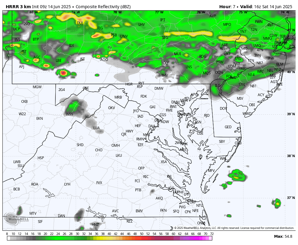
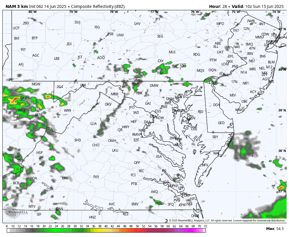
Yesterday proved the challenge we have with this weather pattern. Thunderstorms developed late in the day with individual cells moving, rather drifting in all directions.
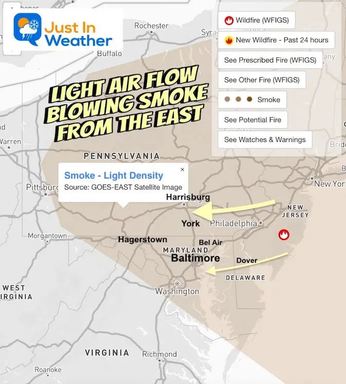
This morning has the added complication of wildfire smoke that has filled the air low to the ground across Northern Maryland and Southern Pennsylvania. A light wind from the East has expanded the plume from the Wharton State Forest Fire in New Jersey.
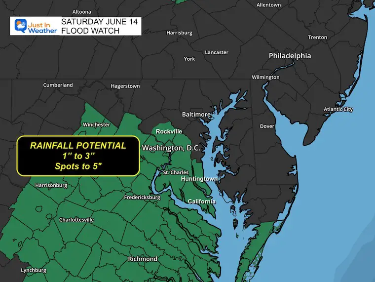
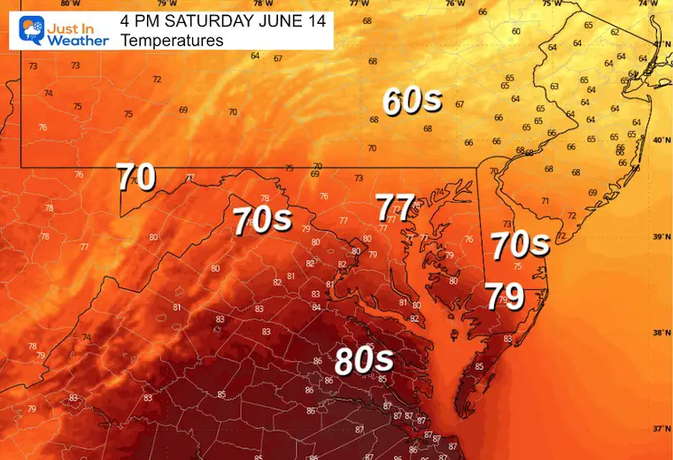
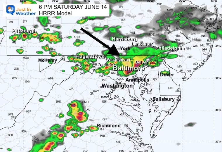
Heavy Rain is a risk again with slow-moving thunderstorms. The heaviest will be in the hotter air to the south, however, there will be a line of strong storms mid-afternoon arriving from the north, which we will track in the simulation below.
There are so many events that I can’t mention them all because I will leave some out. Whatever your plans, I will have the latest suggested timeline radar simulation. Mid-afternoon through tonight is the focus. PLEASE have a safety plan for lightning and heavy rain. This means an indoor place to get to within minutes if and when something pops!
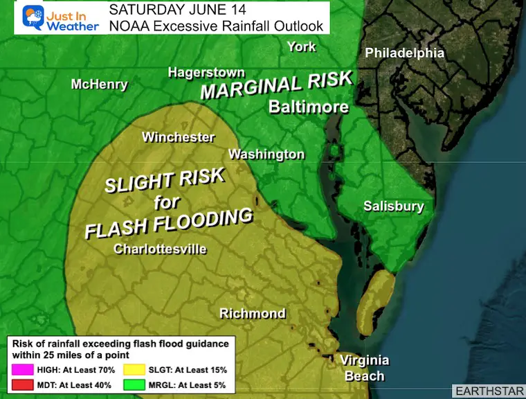
There is a stationary boundary across Maryland as the focus of the rain bands. Impulses are arriving along it from the West, but there is little other forcing, so it is very difficult to pin where the cells will form AND how they will move.
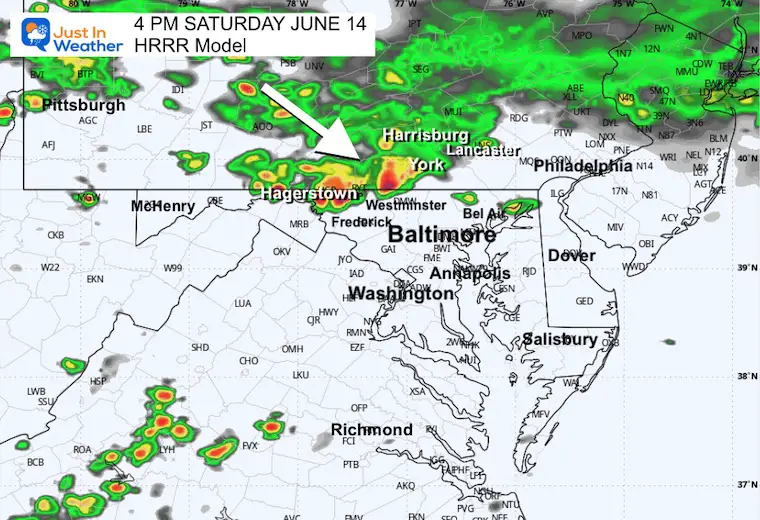
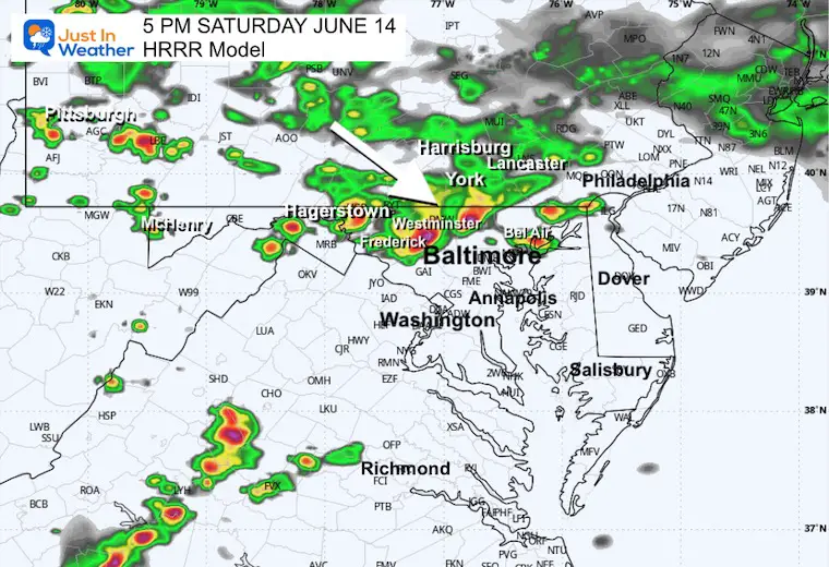
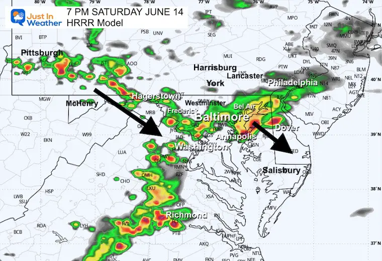
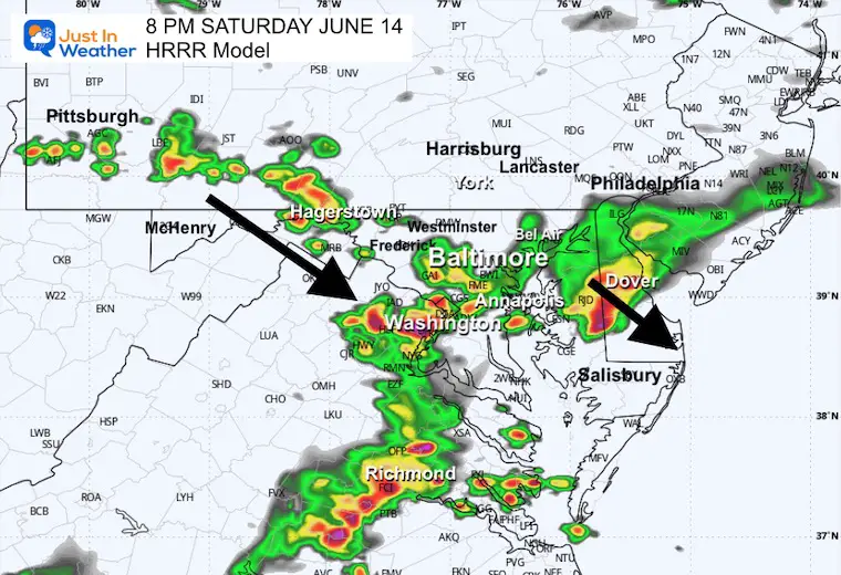
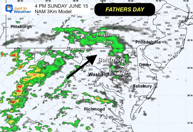
Later this afternoon and evening, a stronger pulse is expected to drop out of Pennsylvania and across Central Maryland. Multiple short-range models plot this between 3 PM and 6 PM…
THEN, a more pronounced line of rain may repeat what happened yesterday in Virginia and Southern Maryland. This will be slow-moving, with heavy rainfall and potential flooding.
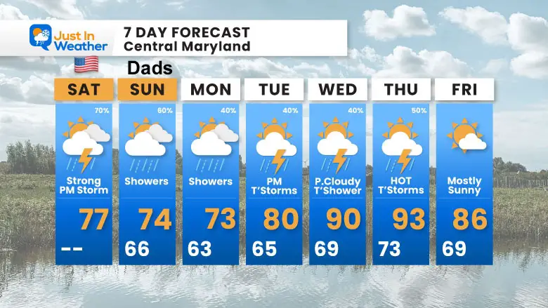
Father’s Day will be cooler with more clouds and lighter rain showers at any time of the day.
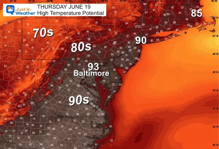
The week ahead will crank up the heat back to the 90s by Thursday. The chance of rain showers or thunderstorms is just about each day… again in a scattered variety.
The stationary front was located south of Washington and the Potomac. To the North, cooler air AND steady rain in PA and NY. To the South still warm and humid.
Low Pressure in Illinois will push more energy East along this boundary and will expand thunderstorms mid-afternoon, then HEAVY RAIN into tonight.
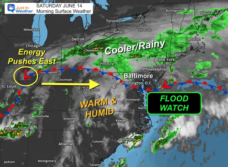
A line of strong storms will develop in Southern Pennsylvania mid-afternoon and drop through Central Maryland between 3 PM and 6 PM, then meet up with a large line of slow-moving rain in Virginia and Southern Maryland.
Subscribe for eMail Alerts
Sign up and be the first to know!
Sunrise at 5:40 AM
Sunset at 8:34 PM
Normal Low in Baltimore: 62ºF
Record 46ºF in 1978
Normal High in Baltimore: 84ºF
Record 98ºF 1994
Rainfall Deficit at BWI
DROUGHT MONITOR
A clear improvement, but some areas in North-Central Maryland are still in a ‘Moderate Drought,’ given the longer deficit.
Maryland Trek 12 August 3 to 9
Our full week team is set. We have our Day 4 all bike ride open for registration.
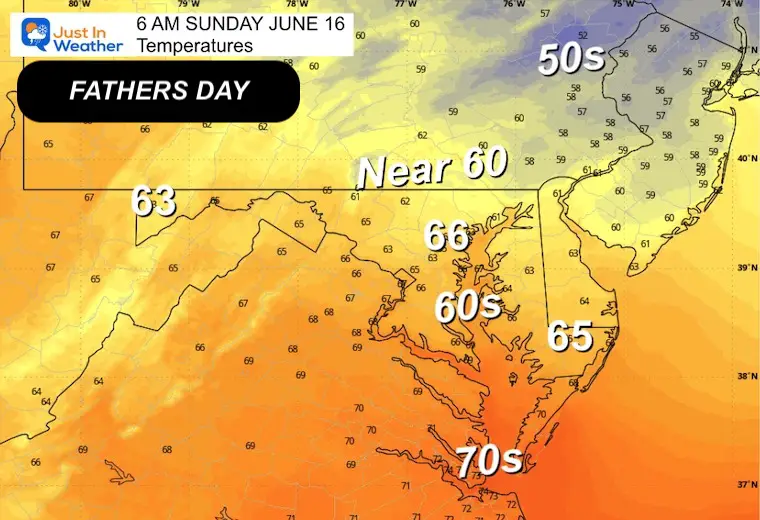
This will be a cooler day with rain showers at any time. The focus will be more in the afternoon, but not at the same intensity.
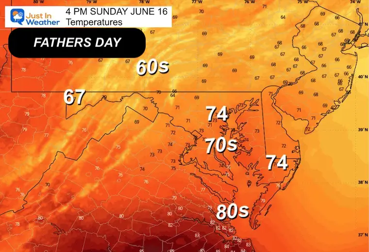
Each day next week, there will be a chance for showers or a thunderstorm. NOT ALL DAY WASHOUTS!
Sign up and be the first to know!
The annual event: Hiking and biking 329 miles in 7 days between The Summit of Wisp to Ocean City.
Each day, we honor a kid and their family’s cancer journey.
Fundraising is for Just In Power Kids: Funding Free Holistic Programs. I never have and never will take a penny. It is all for our nonprofit to operate.
Click here or the image to donate:

I am aware there are some spelling and grammar typos and occasional other glitches. I take responsibility for my mistakes and even the computer glitches I may miss. I have made a few public statements over the years, but if you are new here, you may have missed it: I have dyslexia and found out during my second year at Cornell University. It didn’t stop me from getting my meteorology degree and being the first to get the AMS CBM in the Baltimore/Washington region. One of my professors told me that I had made it that far without knowing and to not let it be a crutch going forward. That was Mark Wysocki, and he was absolutely correct! I do miss my mistakes in my own proofreading. The autocorrect spell check on my computer sometimes does an injustice to make it worse. I also can make mistakes in forecasting. No one is perfect at predicting the future. All of the maps and information are accurate. The ‘wordy’ stuff can get sticky. There has been no editor who can check my work while writing and to have it ready to send out in a newsworthy timeline. Barbara Werner is a member of the web team that helps me maintain this site. She has taken it upon herself to edit typos when she is available. That could be AFTER you read this. I accept this and perhaps proves what you read is really from me… It’s part of my charm. #FITF