Tuesday, June 3 2025
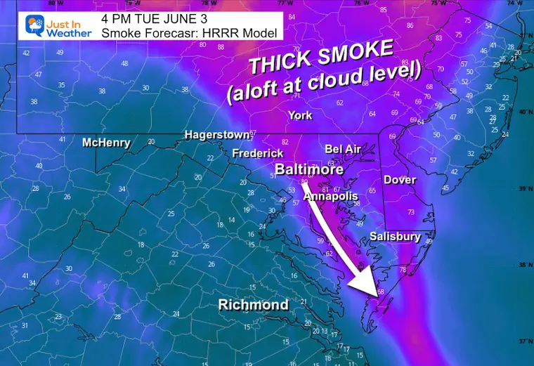
The main story continues to be this round of smoke high in the atmosphere from over 160 Canadian wildfires. The haze returned yesterday and the plume of that smoke is spreading in across the area this morning.
Smokey Orb Sunrise
I went up to Lake Redman in York County, PA this morning to sit out and do my report, while Jackie Diachenko captured the sunrise. This orb is influenced by the smoke refracting the sunlight. This is at cloud level only. The morning air quality level is code green, and the afternoon forecast is code yellow. Well within normal.

Summer heat will finally arrive, but temps may stay below the 90°F mark now. The next weather system will bring in late-day showers on Friday… more likely to reach metro areas at night.
The change here is that Saturday looks more soggy as this front will take all day to cross the region. Then the next wet day looks like Monday as Low Pressure will pass through, a bit like our last event.
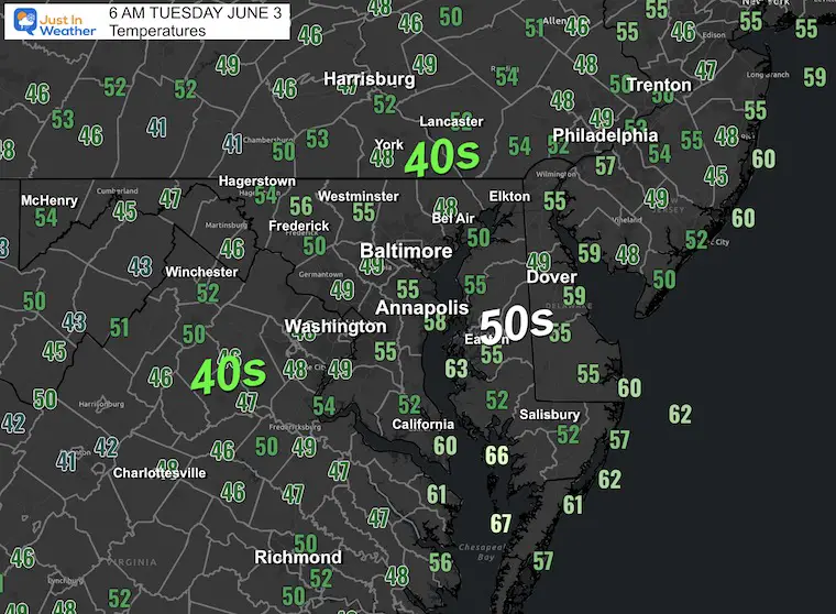
Morning Temperatures
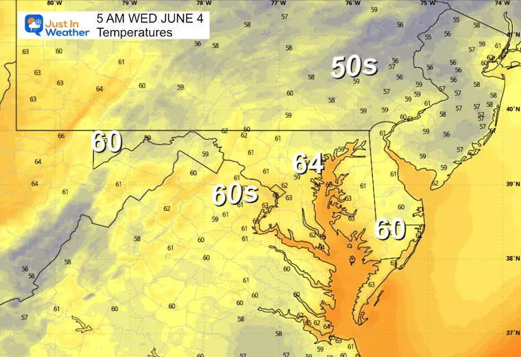
Still unseasonably chilly.
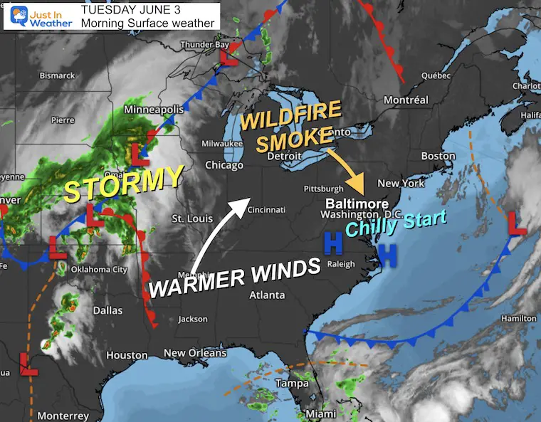
Morning Surface Weather
We are under the control of High Pressure, which brings us a clear sky. However, it is allowing a large pocket of smoke from the Canadian wildfires to slowly shift our way.
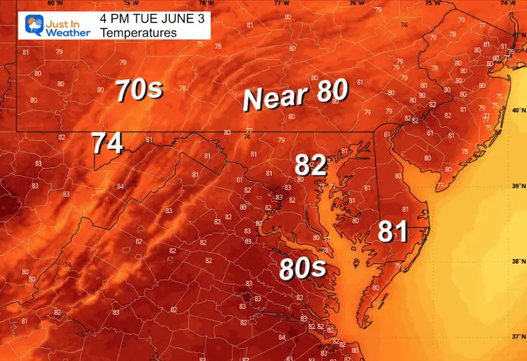
The air will be warming up today and the next few days as the winds shift.
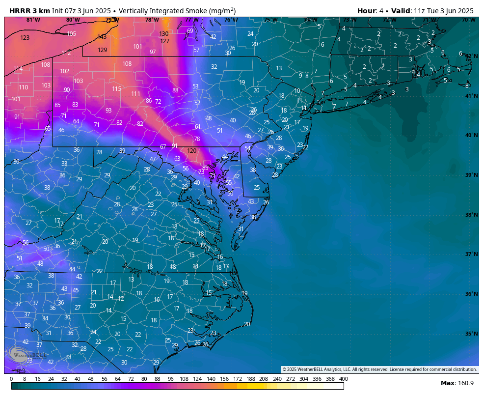
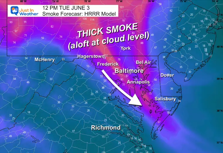
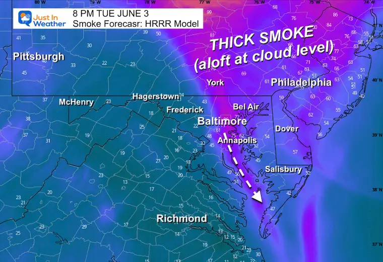
Wildfire Smoke Forecast
HRRR Model 7 AM to 9 PM
Ground air quality forecast is code yellow.
Snapshots
Noon
4 PM
High Temperatures
8 PM
This may make for a vivid sunset.
Baltimore sunset time is 8:29 PM
CLIMATE DATA: Baltimore
TODAY June 3
Sunrise at 5:41 AM
Sunset at 8:29 PM
Normal Low in Baltimore: 59ºF
Record 47ºF in 1986
Normal High in Baltimore: 80ºF
Record 98ºF 1925
Rainfall Deficit at BWI
- Ending 2024 = -8.00”
- Since Jan 1 = -1.27”
- We are STILL DOWN -9.27” INCLUDING LAST YEAR
Subscribe for eMail Alerts
WEDNESDAY
Morning Low Temps
Afternoon Temperatures

LOOKING AHEAD
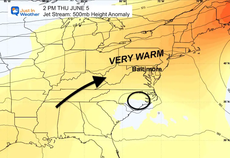
Jet Stream: Thursday Afternoon
As a Ridge builds along the East Coast, we will get the return flow FROM the Southwest. This will pump in warmer air.
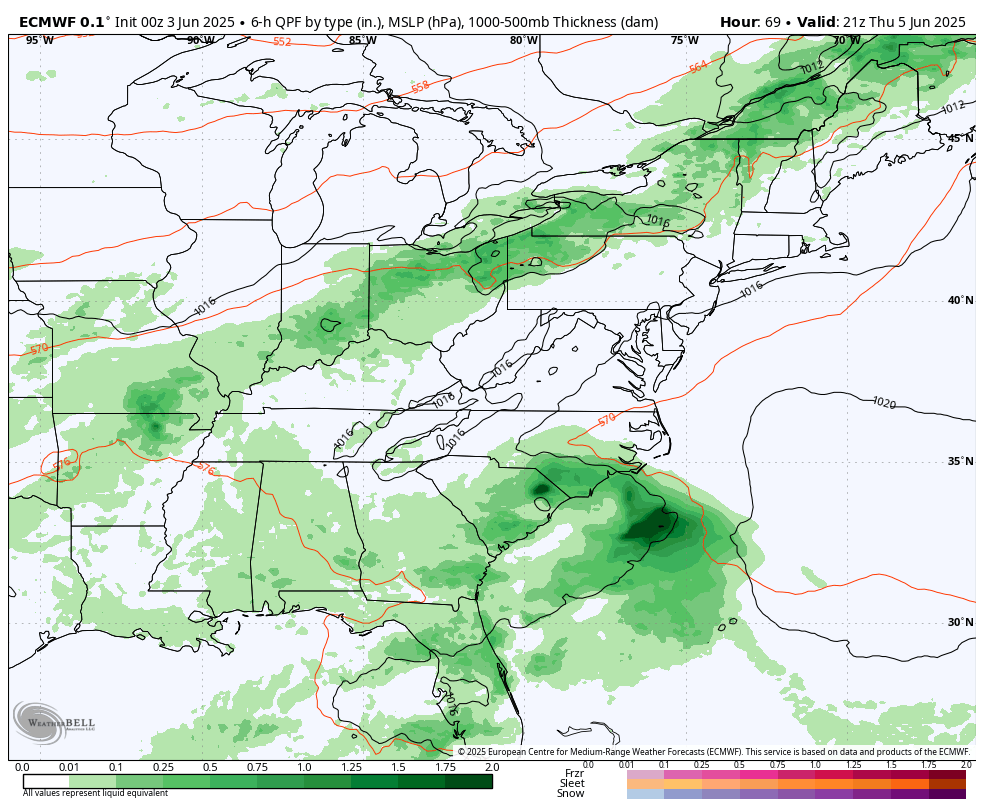
Storm Forecast: Thursday Afternoon to Monday
A cold front will be slow-moving. This may bring a chance of a late storm Friday to our west and north, and arriving in Central Maryland overnight.
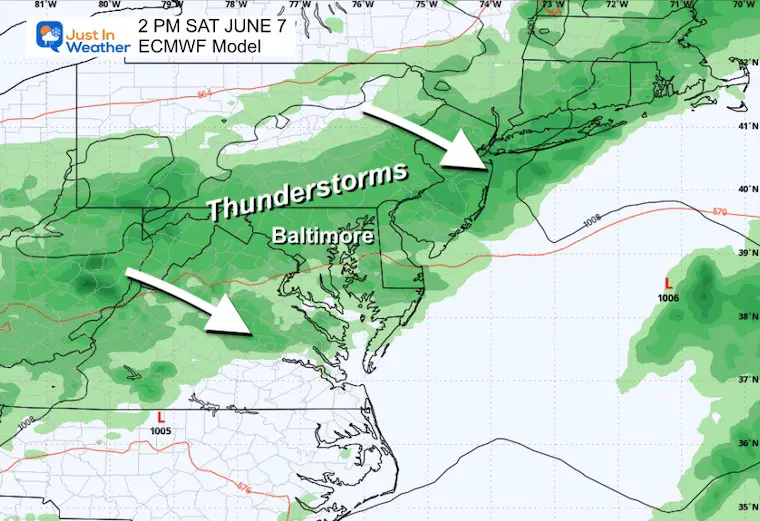
The better chance will be Saturday, and it may turn out soggy.
Sunday will improve, but still some showers in the afternoon.
Monday looks like another low-pressure system to bring more rain.
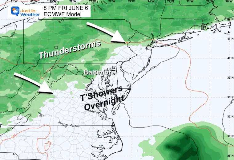
Friday Evening
Storms will cross the Ohio Valley and reach the mountains. The leftovers will cross metro areas at night.
Saturday Afternoon
This day is looking more wet unfortunately.
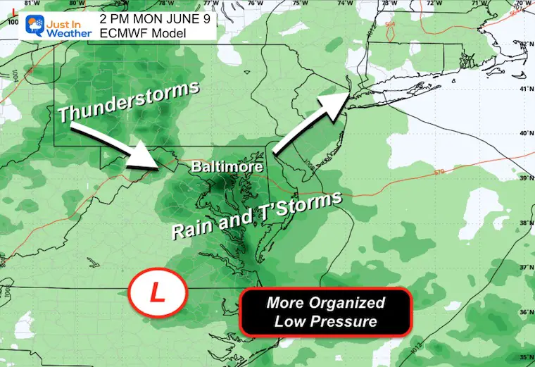
Monday
Another Low Pressure (atmospheric memory) seems to be the case with more rain.
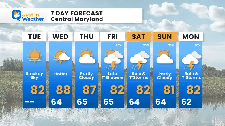
7 Day Forecast
Summer Heat, but not that hot
A chance for thunderstorms late Friday
Saturday is looking wetter.
Subscribe for eMail Alerts
Please share your thoughts and best weather pics/videos, or just keep in touch via social media.
THANK YOU:
Baltimore Magazine Readers Choice Best Of Baltimore
Maryland Trek 11 Day 7 Completed Sat August 10
We raised OVER $111,000 for Just In Power Kids – AND Still Collecting More
The annual event: Hiking and biking 329 miles in 7 days between The Summit of Wisp to Ocean City.
Each day, we honor a kid and their family’s cancer journey.
Fundraising is for Just In Power Kids: Funding Free Holistic Programs. I never have and never will take a penny. It is all for our nonprofit to operate.
Click here or the image to donate:

RESTATING MY MESSAGE ABOUT DYSLEXIA
I am aware there are some spelling and grammar typos and occasional other glitches. I take responsibility for my mistakes and even the computer glitches I may miss. I have made a few public statements over the years, but if you are new here, you may have missed it: I have dyslexia and found out during my second year at Cornell University. It didn’t stop me from getting my meteorology degree and being the first to get the AMS CBM in the Baltimore/Washington region. One of my professors told me that I had made it that far without knowing and to not let it be a crutch going forward. That was Mark Wysocki, and he was absolutely correct! I do miss my mistakes in my own proofreading. The autocorrect spell check on my computer sometimes does an injustice to make it worse. I also can make mistakes in forecasting. No one is perfect at predicting the future. All of the maps and information are accurate. The ‘wordy’ stuff can get sticky. There has been no editor who can check my work while writing and to have it ready to send out in a newsworthy timeline. Barbara Werner is a member of the web team that helps me maintain this site. She has taken it upon herself to edit typos when she is available. That could be AFTER you read this. I accept this and perhaps proves what you read is really from me… It’s part of my charm. #FITF


