April 22 2025
Tuesday Morning Report
If you are celebrating Earth Day, the weather should cooperate. However, the ground may be damp from overnight rain and even morning showers across Lower Delmarva.
A new air mass will move in with Northwest winds, lowering the humidity and bringing back the sunshine. Temperatures will remain warm for the next few afternoons.
The next chance for rain will be Friday to Saturday.
Clean Up Continues
Here is another storm impact zone from Saturday Night at a campground in Hancock, Maryland.
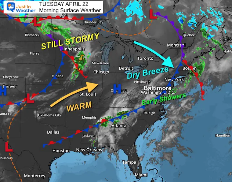
Today’s Weather
A cold front is still crossing the region and off the coast. Morning showers are seen on radar across Southern Maryland and to the coast.
Winds will increase a bit as a new dry air mass moves in during the day. This will continue to push the rain away along with the clouds.
Sun with lower humidity expected this afternoon.
Live Radar Widget
CLIMATE DATA: Baltimore
TODAY April 22
Sunrise at 6:20 AM
Sunset at 7:51 PM
Normal Low in Baltimore: 46ºF
Record 32ºF in 1875
Normal High in Baltimore: 69ºF
Record 93ºF 1985
Drought Reminder
Rainfall Deficit at BWI
- Ending 2024 = -8.00”
- Since Jan 1 = -3.41”
- We are DOWN -11.41” including last year
Subscribe for eMail Alerts
Morning Temperatures

Surface Weather
Morning rain showers along the cold front will exit Maryland’s Lower Eastern Shore this morning.
A breeze from the northwest will increase midday and lower the humidity.
A warm air mass will push East for two days, then that storm system will expand and slowly cross our region Friday and Saturday.
Wind Forecast 8 AM to 8 PM
The wind will increase FROM THE NORTHWEST.

Wind Forecast at Noon
Gusts will be up to 20 mph, bringing in lower humidity and a return of sunshine.

Afternoon Temperatures
Most areas will be about 10 degrees warmer than yesterday.

WEDNESDAY
Sunny and Warm.
Morning Temperatures

Afternoon Temperatures

Looking Ahead:
Storm Forecast Thursday To Sunday
While the models have not performed well, there has been persistence with this weekend’s event.
Rain and thunderstorms will develop in the mountains on Friday. This may reach metro areas overnight, and Saturday looks very wet.
Sunday will cool down a little and clear out.

Snapshots
Friday Night
Rain will fall over the mountains and may pass through metro areas overnight.

Saturday Morning

Saturday Afternoon

Saturday Night

Rain Total Ending Saturday Night

7 Day Forecast
- Sunny and Warm Mid-Week
- Friday: Showers and Thunderstorms in the mountains may reach metro areas at night.
- Saturday looks soggy!
- Sunday: Clearing out.

Subscribe for eMail Alerts
Please share your thoughts and best weather pics/videos, or just keep in touch via social media.
SCHEDULE A WEATHER BASED STEM ASSEMBLY
Severe Weather: Storm Smart October and next spring Winter Weather FITF (Faith in the Flakes): November To March Click to see more and send a request for your school.

THANK YOU:
Baltimore Magazine Readers Choice Best Of Baltimore
Maryland Trek 11 Day 7 Completed Sat August 10
We raised OVER $104,000 for Just In Power Kids – AND Still Collecting More
The annual event: Hiking and biking 329 miles in 7 days between The Summit of Wisp to Ocean City.
Each day, we honor a kid and their family’s cancer journey.
Fundraising is for Just In Power Kids: Funding Free Holistic Programs. I never have and never will take a penny. It is all for our nonprofit to operate.
Click here or the image to donate:

RESTATING MY MESSAGE ABOUT DYSLEXIA
I am aware there are some spelling and grammar typos and occasional other glitches. I take responsibility for my mistakes and even the computer glitches I may miss. I have made a few public statements over the years, but if you are new here, you may have missed it: I have dyslexia and found out during my second year at Cornell University. It didn’t stop me from getting my meteorology degree and being the first to get the AMS CBM in the Baltimore/Washington region. One of my professors told me that I had made it that far without knowing and to not let it be a crutch going forward. That was Mark Wysocki, and he was absolutely correct! I do miss my mistakes in my own proofreading. The autocorrect spell check on my computer sometimes does an injustice to make it worse. I also can make mistakes in forecasting. No one is perfect at predicting the future. All of the maps and information are accurate. The ‘wordy’ stuff can get sticky. There has been no editor who can check my work while writing and to have it ready to send out in a newsworthy timeline. Barbara Werner is a member of the web team that helps me maintain this site. She has taken it upon herself to edit typos when she is available. That could be AFTER you read this. I accept this and perhaps proves what you read is really from me… It’s part of my charm. #FITF


