February 25, 2025
Tuesday Morning Report
Do you remember the active winter weather pattern we had most of this month? There was a storm to track every 2 to 3 days! Now, we have a pattern with warmer air but a cold front every 2 to 3 days.
These cold fronts will look impressive on the weather map, but as they cross the mountains, they will lose some energy. So we track spotty showers that break up and may not reach everyone… The higher chance will be in the western and northern hills.
Our next surge of colder air will arrive later this weekend. A larger pattern shift will be attempted next and maybe the last Polar Push during the second week of March.
CLIMATE DATA: Baltimore
TODAY February 25
Sunrise at 6:45 AM
Sunset at 5:55 PM
Normal Low in Baltimore: 29ºF
Record 8ºF in 1894; 1900; 1914
Normal High in Baltimore: 49ºF
Record 83ºF 1930
Baltimore Seasonal Snow
12.7”
DROUGHT UPDATE
Rainfall Deficit at BWI
- Ending 2024 = -8.00”
- Since Jan 1 = -1.67”
- We are DOWN -9.67” including last year
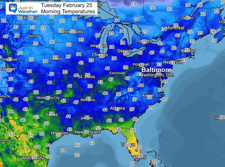
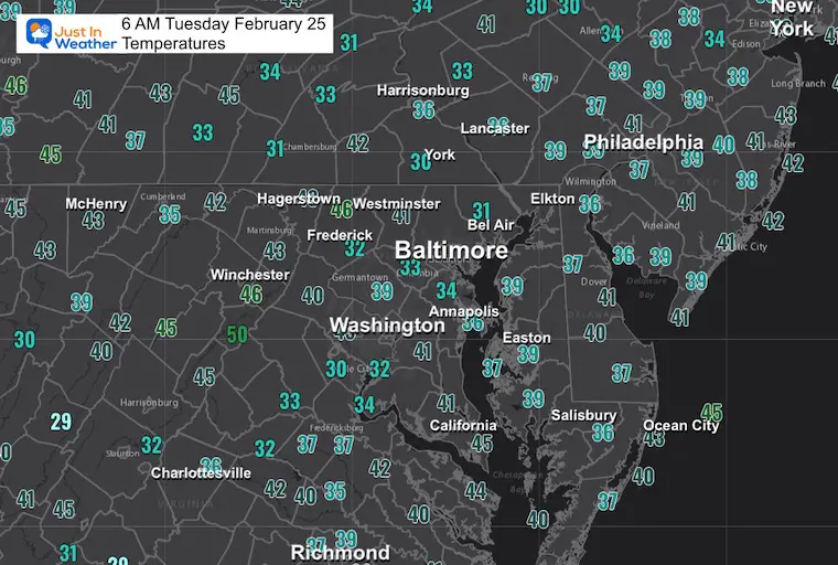
Morning Temperatures
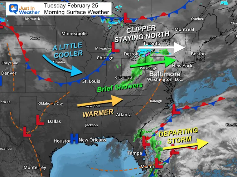
Morning Surface Weather
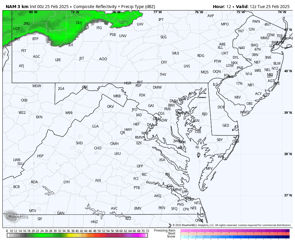
A very active weather map with quick-moving systems and air masses.
The clipper across the Great Lakes has a trailing cold front with rain showers into the mountains. This will fall apart as it heads East… But brief rain may reach the Maryland mountains and Southern Pennsylvania.
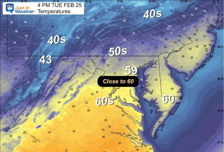
The next few days will be warmer.
Local Morning Temperatures
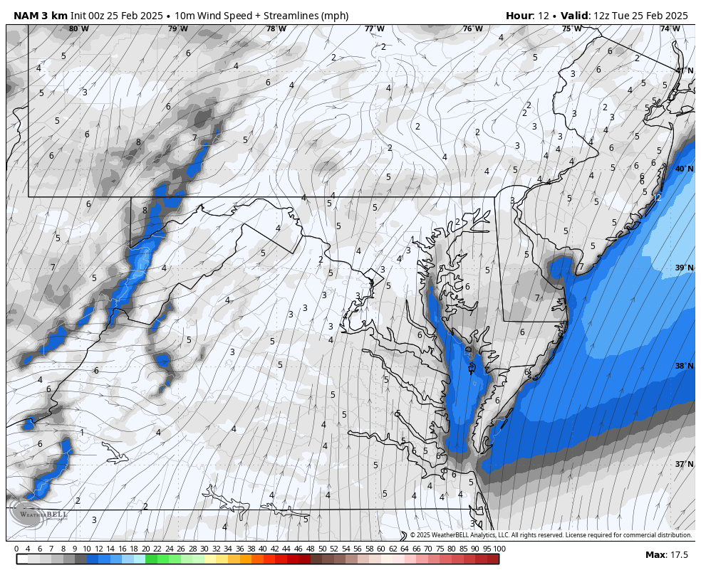
Wind Forecast: 7 AM to 7 PM
Radar Simulation: 7 AM to 7 PM
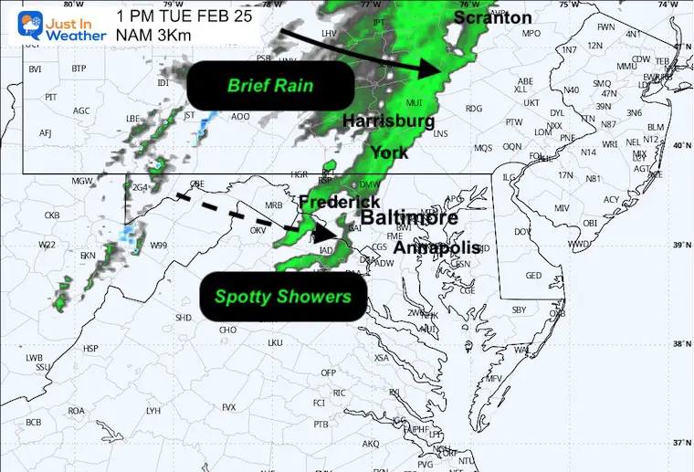
Snapshot at 1 PM
If the rain showers survive East of the mountains, a brief hit will arrive early afternoon.
Afternoon Temperatures
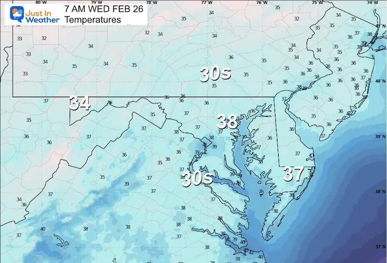
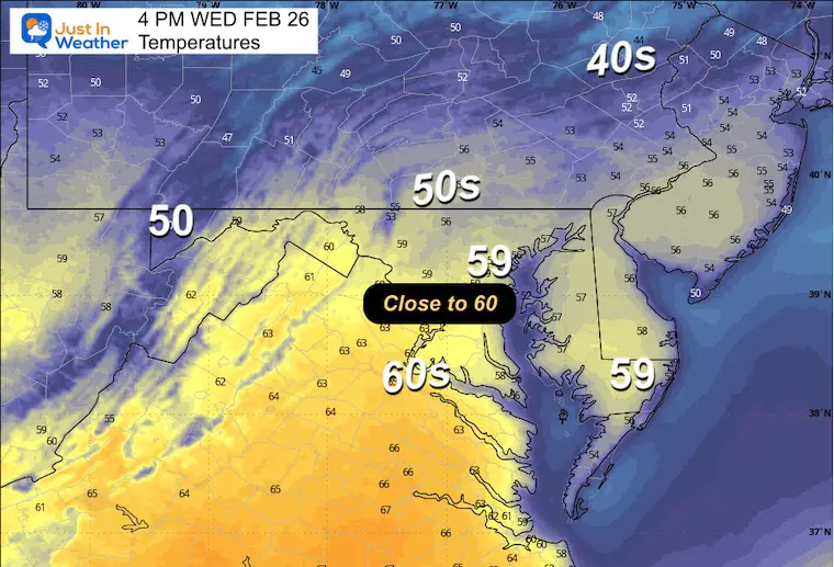
WEDNESDAY WEATHER
Morning Temperatures
Afternoon Temperatures
LOOKING AHEAD
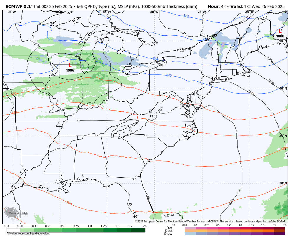
Storm Forecast: Wednesday Afternoon to Sunday
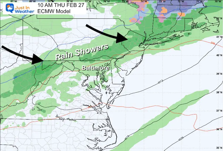
A series of cold fronts will bring more wind to us than anything. However, each front will bring rain showers that may last a couple of hours. The stronger system will be on Thursday.
Snapshot Thursday
A few hours of heavier rain is possible with this cold front.
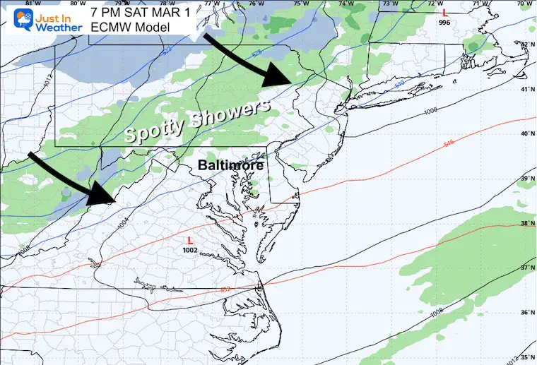
Snapshot Saturday
Brief showers with this cold front.
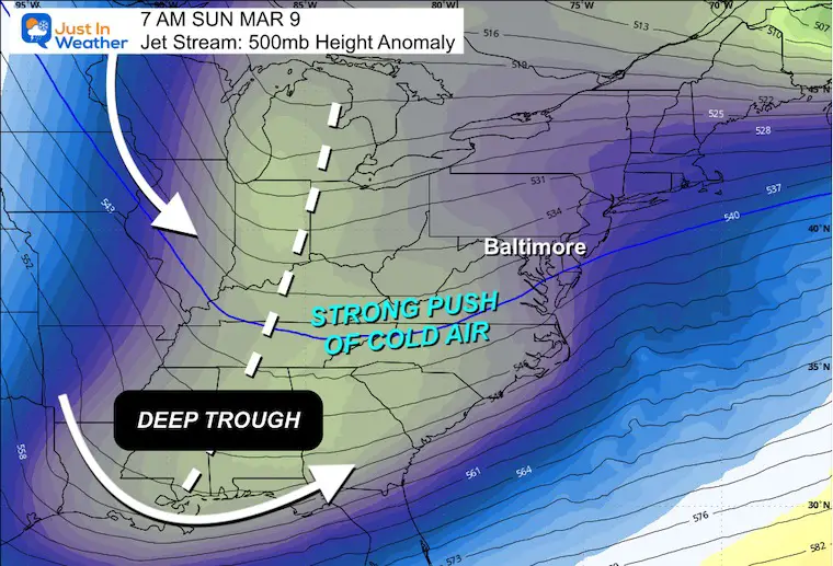
Jet Stream Forecast: Sunday March 2 to Monday March 10
Variable weather is common in March as the battle continues between Spring trying to push North and Winter Cold fighting back.
The latest big push of winter weather may arrive during the second week of March.
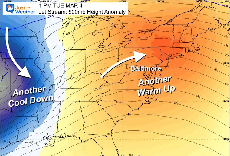
Next Tuesday: March 4
Another Warm-Up: This could bring us back closer to 60F.
The following Monday, March 10
A Deep Trough = Much colder and perhaps stormy.
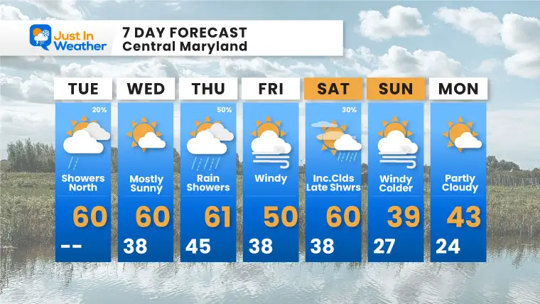
7 Day Forecast
Our new pattern brings a cold front every 2 to 3 days. We will have a very warm stretch near 60F this week, then it will be much colder by Sunday.
Subscribe for eMail Alerts
SNOW REPORTS THIS SEASON
Click on the maps for that full report.
February 11 Snow Report And Grade My Forecast
click here or the map for more

January 19 Snow Report

January 11 Snow Report

January 6 Snow Report

Previous Snow

ALSO SEE
Recent Snow Reports
La Nina Advisory January 2025
Full Report

MY WINTER OUTLOOK
My Winter Outlook Report

FITF Gear on Sale

In Case You Missed This
The Faith In The Flakes Dec 5 Origin Story

Please share your thoughts and best weather pics/videos, or just keep in touch via social media.
SCHEDULE A WEATHER BASED STEM ASSEMBLY
Severe Weather: Storm Smart October and next spring Winter Weather FITF (Faith in the Flakes): November To March Click to see more and send a request for your school.

THANK YOU:
Baltimore Magazine Readers Choice Best Of Baltimore
Maryland Trek 11 Day 7 Completed Sat August 10
We raised OVER $104,000 for Just In Power Kids – AND Still Collecting More
The annual event: Hiking and biking 329 miles in 7 days between The Summit of Wisp to Ocean City.
Each day, we honor a kid and their family’s cancer journey.
Fundraising is for Just In Power Kids: Funding Free Holistic Programs. I never have and never will take a penny. It is all for our nonprofit to operate.
Click here or the image to donate:

RESTATING MY MESSAGE ABOUT DYSLEXIA
I am aware there are some spelling and grammar typos and occasional other glitches. I take responsibility for my mistakes and even the computer glitches I may miss. I have made a few public statements over the years, but if you are new here, you may have missed it: I have dyslexia and found out during my second year at Cornell University. It didn’t stop me from getting my meteorology degree and being the first to get the AMS CBM in the Baltimore/Washington region. One of my professors told me that I had made it that far without knowing and to not let it be a crutch going forward. That was Mark Wysocki, and he was absolutely correct! I do miss my mistakes in my own proofreading. The autocorrect spell check on my computer sometimes does an injustice to make it worse. I also can make mistakes in forecasting. No one is perfect at predicting the future. All of the maps and information are accurate. The ‘wordy’ stuff can get sticky. There has been no editor who can check my work while writing and to have it ready to send out in a newsworthy timeline. Barbara Werner is a member of the web team that helps me maintain this site. She has taken it upon herself to edit typos when she is available. That could be AFTER you read this. I accept this and perhaps proves what you read is really from me… It’s part of my charm. #FITF


