Wednesday Afternoon February 19 2025
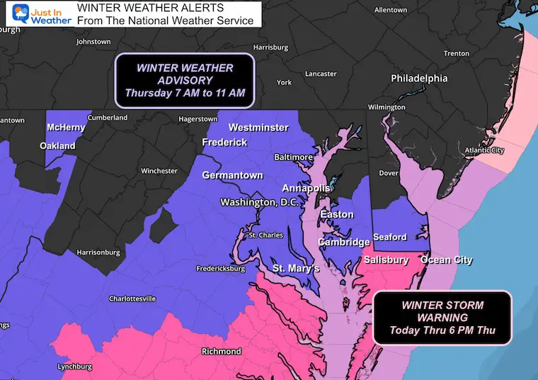
Today, the winter storm is developing, and snow has reached parts of Central Maryland north of the computer model forecast, as I suggested. I was all excited to share the feature of the Baroclinic Leaf with you, and then the National Weather Service has added a NEW Winter Weather Advisory for parts of Central Maryland. This is for the additional light snow tomorrow with the second piece of energy. Nothing is new with my forecast, but this may get some additional attention.
Winter Storm Warning and Advisory:
From The National Weather Service
The new area includes metro Washington, DC, and parts of metro Baltimore.
In Central Maryland: Frederick, Carroll, Baltimore, Montgomery, Howard, Prince George, and Anne Arundel counties.
Southern Pennsylvania may get added later, as I see the same weather there.
Let me get this out of the way…
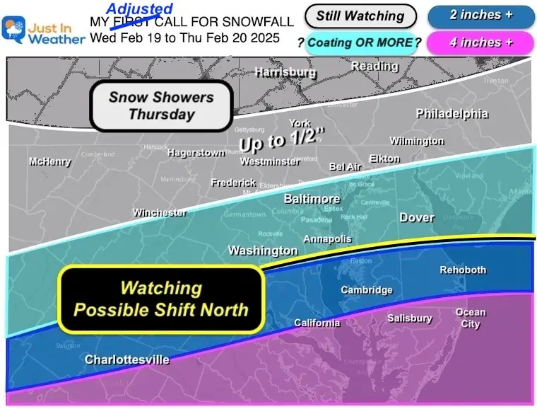
My Call For Snowfall (updated last night)
I only made a slight adjustment to my first call map and left it easy to identify… The wider range of snow showers on the north end.
Wednesday Afternoon Set Up
Close-Up Doppler Radar
The snow was seen very close to the line that included Washington, D.C., Annapolis… and just south of Baltimore.
Flurries may be reaching the ground in Northeastern Maryland’s Harford and Cecil Counties.
This may not seem like a big deal, but proves my efforts to suggest the snow would fall farther NORTH of where the models suggested.
Yes, I feel some vindication.
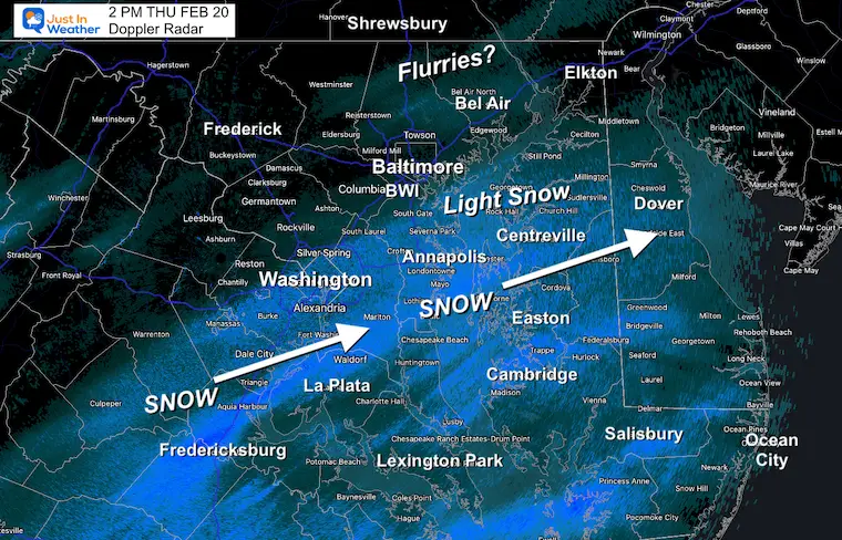
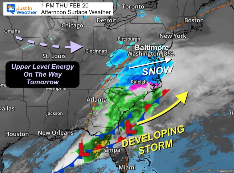
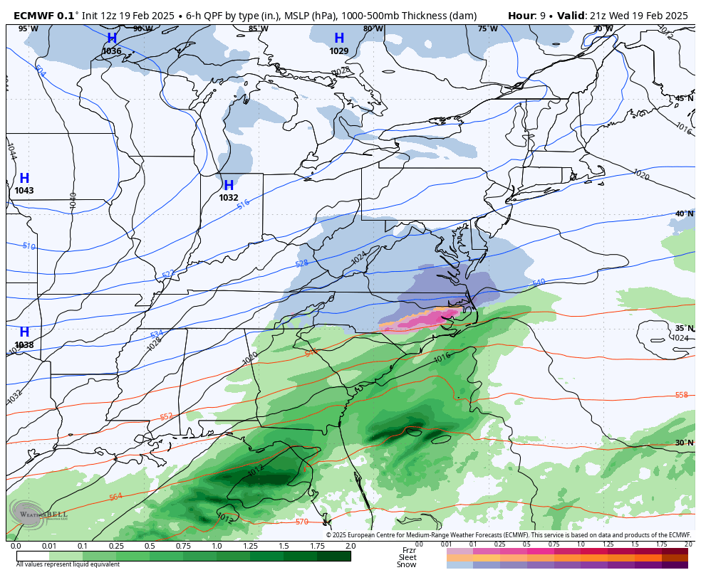
The storm has taken form with light snow reaching into Maryland just south of Baltimore.
Heavier snow is falling across Southeast Virginia and Eastern North Carolina. The main Low Pressure is in the Gulf west of Tampa.
Our next focus will be the energy in the jet stream that will cross the Midwest tonight and reach us tomorrow for that second impulse of light snow.
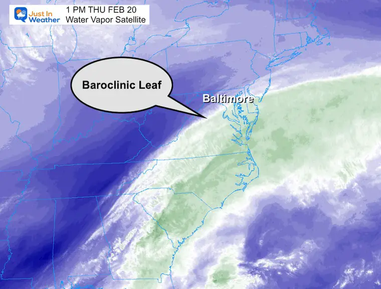
Baroclinic Leaf
This is a feature seen on the Water Vapor satellite with a developing storm. A bright band on the edge of the main cloud line develops and shows the likely northward reach where steady snow can develop. I mentioned this in a prior report with the January 2000 winter storm.
This was seen at 1 PM along a line from Washington DC and Annapolis.
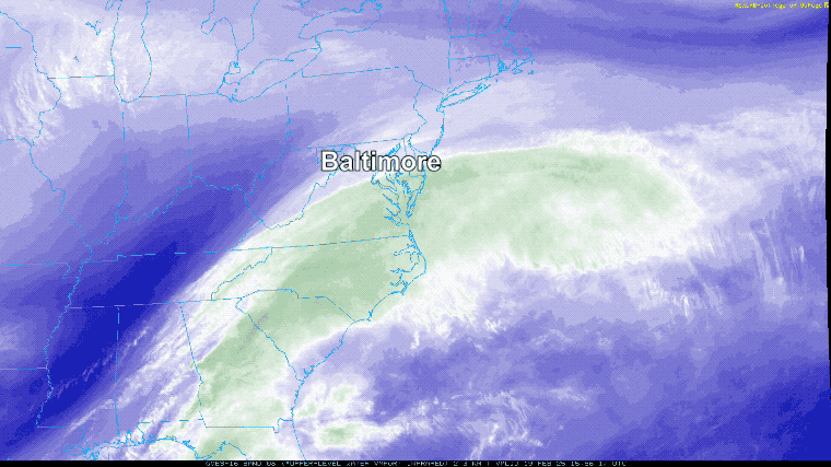
Water Vapor Satellite Loop 11 AM to 1 PM
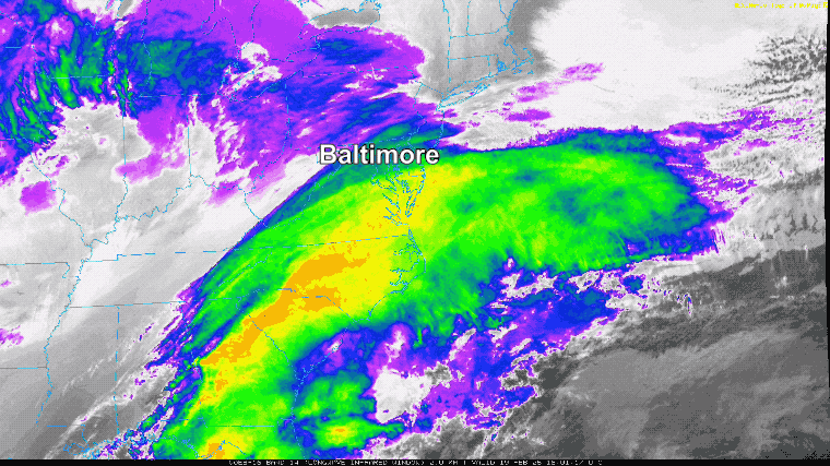
Infrared Satellite Loop 11 AM to 1 PM
Wider View
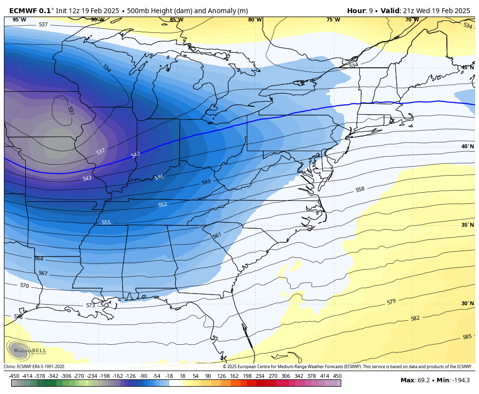
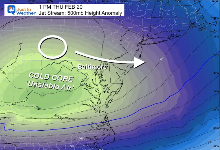
Jet Stream Forecast
4 PM Wed to 7 PM Thu
The other part of this storm that did not match up in time for a major event, will swing through tomorrow. This is the additional energy for light snow developing.
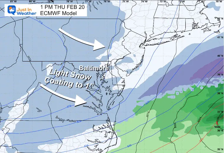
Storm Forecast From ECMWF Model
4 PM Wed to 7 PM Thu
The main event will pass south, then the light snow will develop from The Midwest with additional energy tomorrow.
Snapshots 1 PM Thursday
Jet Stream
Surface Weather
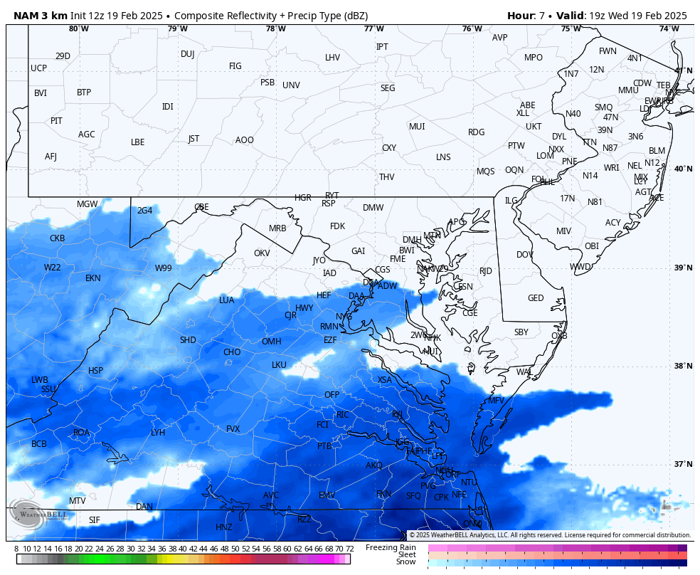
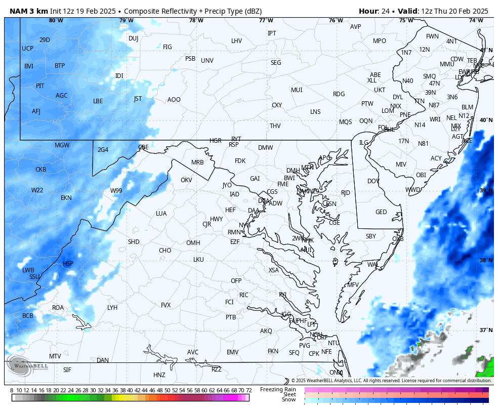
Forecast Radar NAM 3 Km
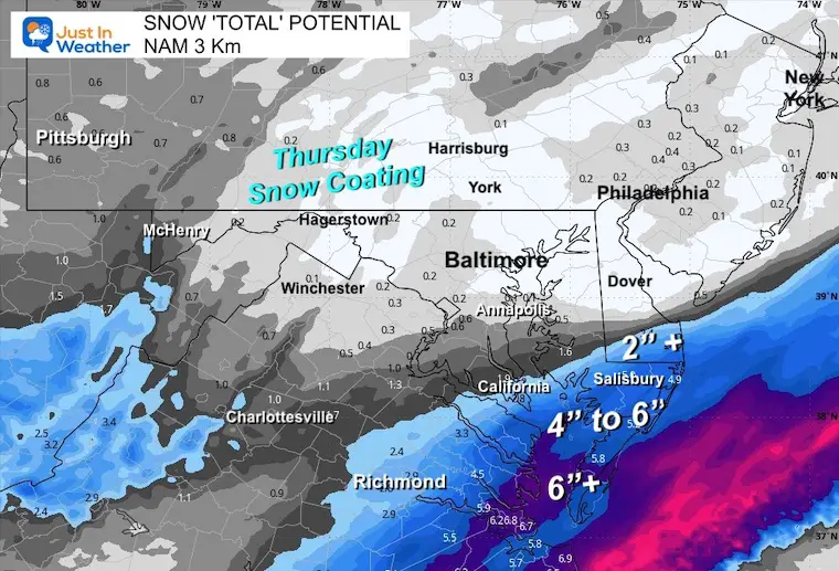
Again, this is the model that performed best with last weekend’s snow and sleet burst.
2 PM to Midnight
THURSDAY SNOW
7 AM to 7 PM
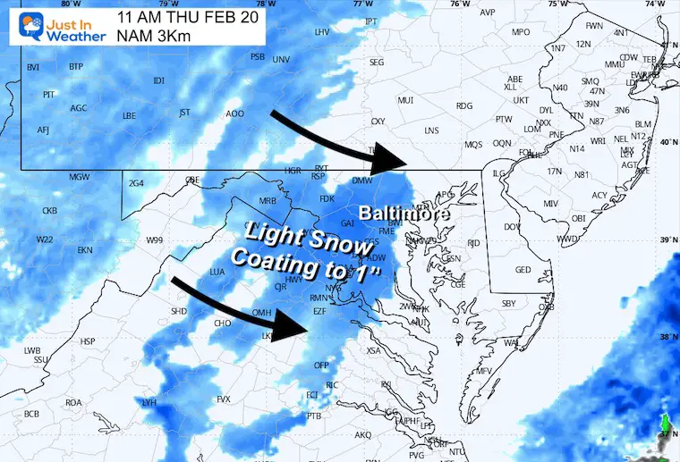
Snapshot at 11 AM
There will be a few hours with steady light snow or snow showers.
This may be enough to range from a coating to 1 inch of snow.
Yes, temps are cold enough for stickage on the pavement. If this arrives earlier, it may impact part of the commute.
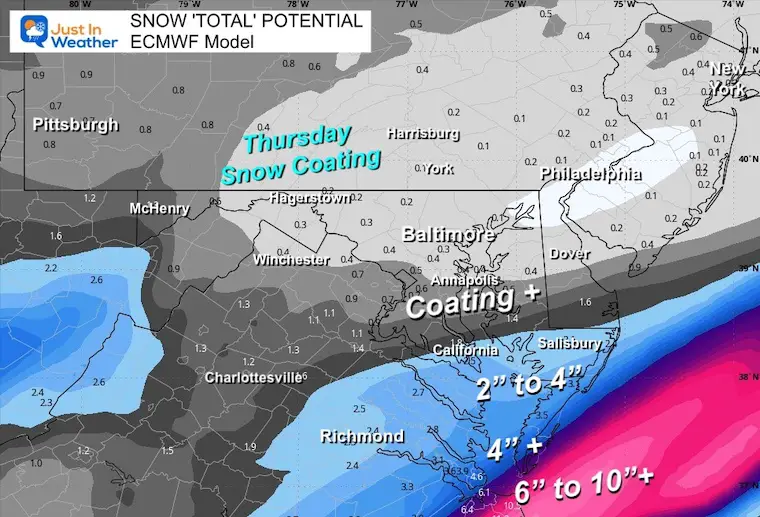
Snow POTENTIAL Total Forecast
ECMWF Model
GFS Model
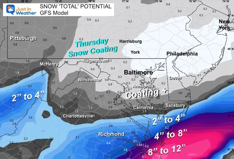
NAM 3Km
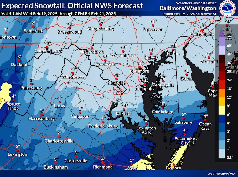
National Weather Service
Repeat My Call For Snowfall
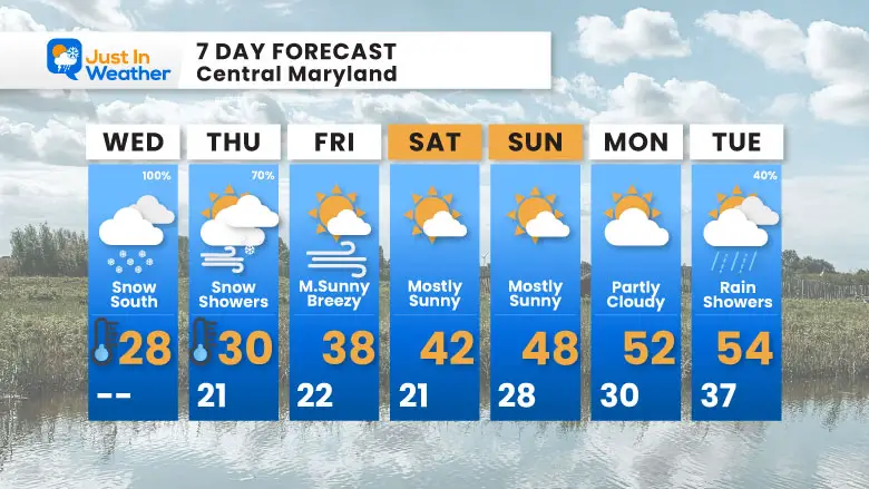
7 Day Forecast
Edge Of Polar Cold AND Southern Storm Through Thursday
Weekend: Storm Pattern Breaks!
Mild 50s Next Week
Subscribe for eMail Alerts
SNOW REPORTS THIS SEASON
Click on the maps for that full report.
February 11 Snow Report And Grade My Forecast
click here or the map for more

January 19 Snow Report

January 11 Snow Report

January 6 Snow Report

Previous Snow

ALSO SEE
Recent Snow Reports
La Nina Advisory January 2025
Full Report

MY WINTER OUTLOOK
My Winter Outlook Report

FITF Gear on Sale

In Case You Missed This
The Faith In The Flakes Dec 5 Origin Story

Please share your thoughts and best weather pics/videos, or just keep in touch via social media.
SCHEDULE A WEATHER BASED STEM ASSEMBLY
Severe Weather: Storm Smart October and next spring Winter Weather FITF (Faith in the Flakes): November To March Click to see more and send a request for your school.

THANK YOU:
Baltimore Magazine Readers Choice Best Of Baltimore
Maryland Trek 11 Day 7 Completed Sat August 10
We raised OVER $104,000 for Just In Power Kids – AND Still Collecting More
The annual event: Hiking and biking 329 miles in 7 days between The Summit of Wisp to Ocean City.
Each day, we honor a kid and their family’s cancer journey.
Fundraising is for Just In Power Kids: Funding Free Holistic Programs. I never have and never will take a penny. It is all for our nonprofit to operate.
Click here or the image to donate:

RESTATING MY MESSAGE ABOUT DYSLEXIA
I am aware there are some spelling and grammar typos and occasional other glitches. I take responsibility for my mistakes and even the computer glitches I may miss. I have made a few public statements over the years, but if you are new here, you may have missed it: I have dyslexia and found out during my second year at Cornell University. It didn’t stop me from getting my meteorology degree and being the first to get the AMS CBM in the Baltimore/Washington region. One of my professors told me that I had made it that far without knowing and to not let it be a crutch going forward. That was Mark Wysocki, and he was absolutely correct! I do miss my mistakes in my own proofreading. The autocorrect spell check on my computer sometimes does an injustice to make it worse. I also can make mistakes in forecasting. No one is perfect at predicting the future. All of the maps and information are accurate. The ‘wordy’ stuff can get sticky. There has been no editor who can check my work while writing and to have it ready to send out in a newsworthy timeline. Barbara Werner is a member of the web team that helps me maintain this site. She has taken it upon herself to edit typos when she is available. That could be AFTER you read this. I accept this and perhaps proves what you read is really from me… It’s part of my charm. #FITF


