Wednesday Night, February 19 2025
Two things jumped out to me tonight. First, we really just missed that major winter storm from fully developing. The setup in the atmosphere is impressive; but the energy is about 12 hours apart. It is that second part we still have to deal with on Thursday, and it is potent!
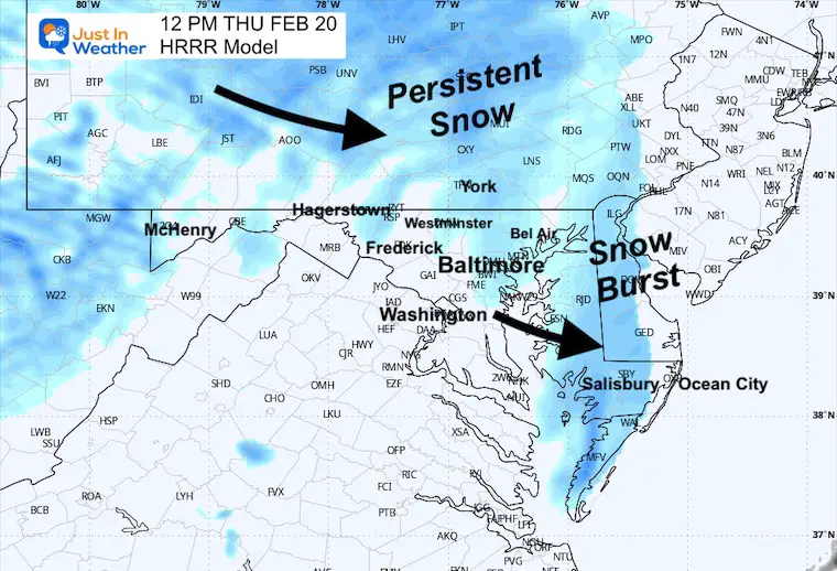
A burst of snow will impact us mid-morning into the afternoon.
This is IMPORTANT! Temps will be well below freezing. Despite the higher sun angle, I do believe any snow that falls will have a chance to stick. Even a coating of 1/2 inch can lead to big travel problems from mid-morning to the afternoon.
I want to show you the evening set-up, which will take us to this hyper-focused hourly timeline for the snow on Thursday. Short-range models now have a grip on Mid Atlantic snow, which gives more confidence to the timeline.
Ocean City Snow Winner
This photo was taken earlier this evening, and they do have a chance to reach a total of 6 inches tonight.
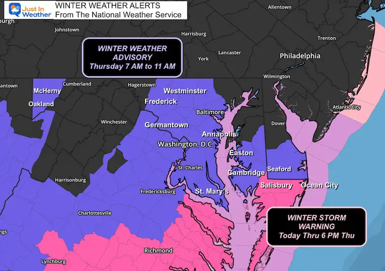
Winter Storm Warning and Advisory:
From The National Weather Service
The new area includes metro Washington, DC, and parts of metro Baltimore.
In Central Maryland: Frederick, Carroll, Baltimore, Montgomery, Howard, Prince George, and Anne Arundel counties.
Southern Pennsylvania will also be affected by the snow, but the criteria for an advisory there are higher and may not be met.
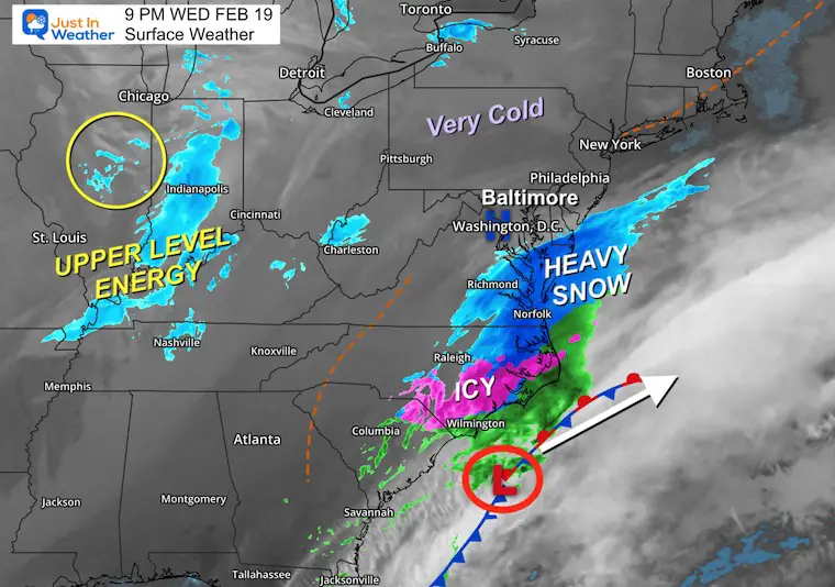
Wednesday Night Set Up
Low Pressure was located Southwest of Wilmington, NC. The Northern edge of steady and heavy snow reached into lower Delmarva. I have a closer look below.
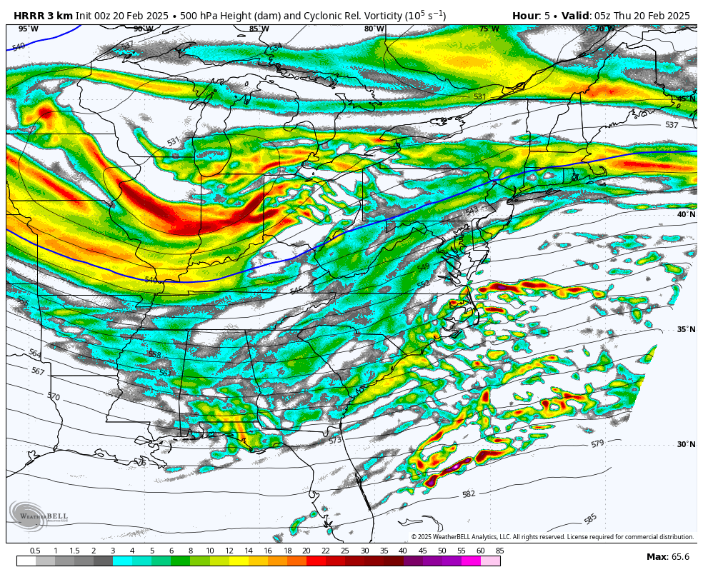
The band of snow in Indiana is part of the Upper Level Energy that is the second piece to dive through Thursday morning.
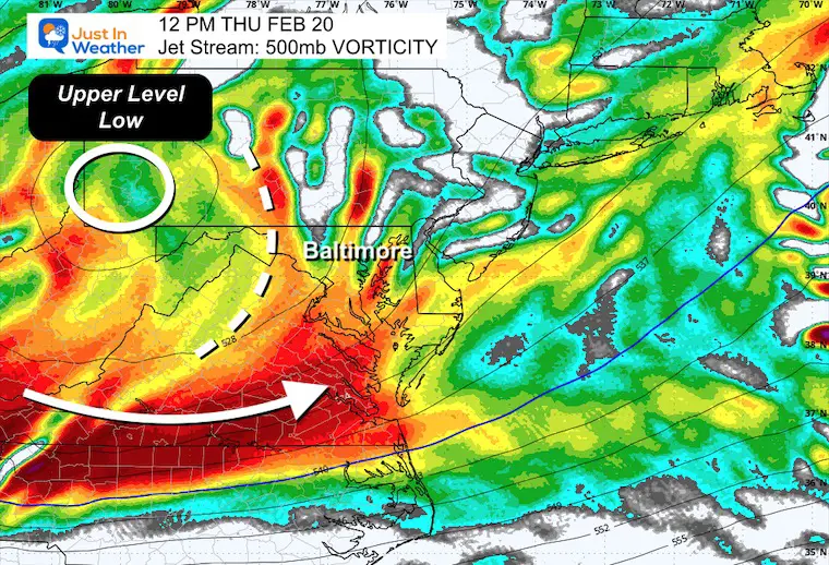
Jet Stream Vorticity Forecast
Midnight to 4 PM Thursday
The Upper-Level Low can be seen spinning through Central Maryland.
The Vort maxes orbit around it like spokes of intense energy that will develop a cluster of snow.
Thursday Noon Snapshot
This is the impulse that will enhance the snow throughout the day.
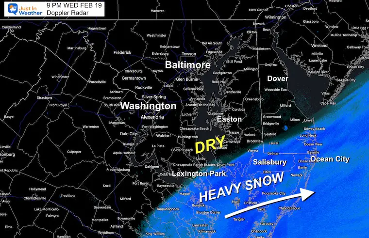
9 PM Doppler Radar
Here is a closer look at the snow tonight. There is a very sharp cutoff from moderate snow to dry air. Salisbury and Ocean City still have a few hours of additional snowfall.
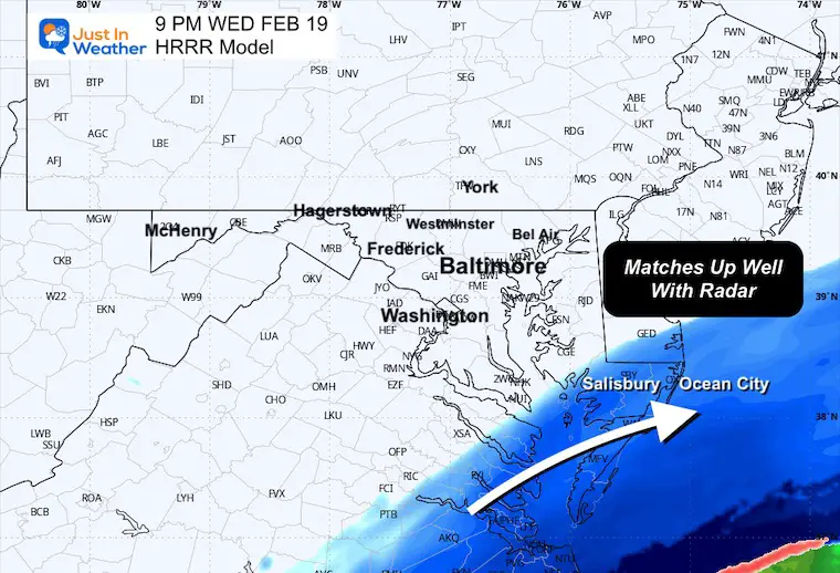
9 PM Forecast From HRRR Model
This was a few hours ago, and it held up well. I will track this model run through tomorrow for the additional snow.
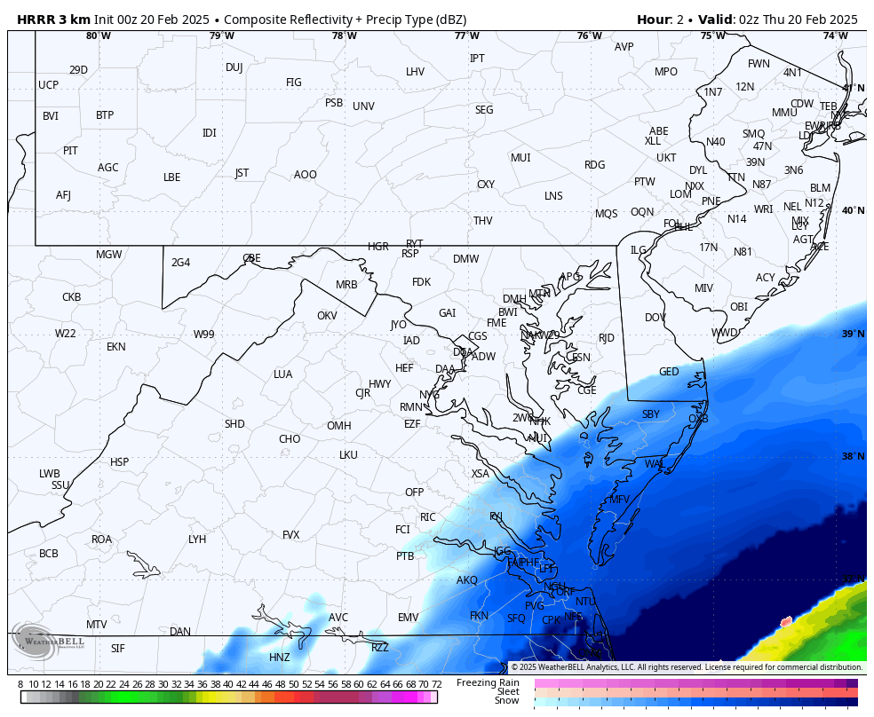
HRRR Model Forecast 10 PM Wed to 4 PM Thu
The snow will develop from mid-morning to noon, and then the cold winds will ignite Lake Enhanced Snow Showers from the Northwest through the afternoon.
Key Time Frames Thursday
NOTE: Please allow a buffer of up to 1 hour to account for any model error. This should be close…
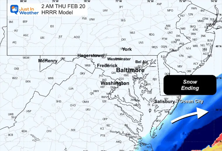
2 AM
This shows the end of the snow for Ocean City.
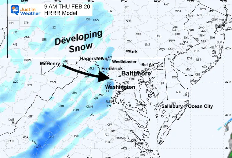
9 AM
Tracking the developing snow across the mountains… and expanding as it heads east.
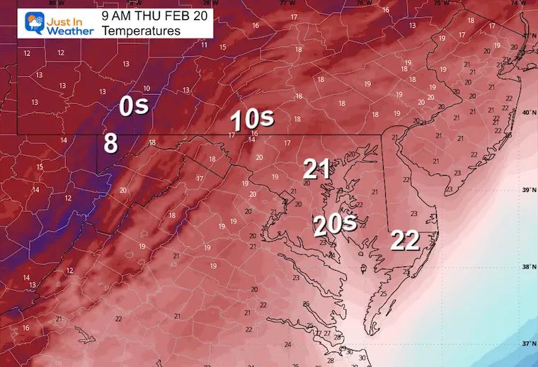
Temperatures
This is IMPORTANT! We will be well below freezing. Despite the higher sun angle, I do believe any snow that falls will have a chance to stick. Even a coating to 1/2 inch can lead to big travel problems mid-morning to the afternoon.
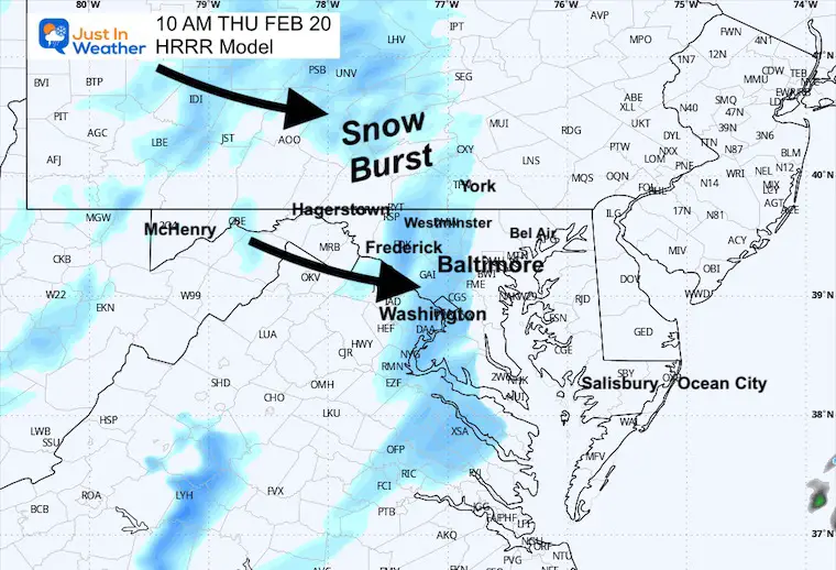
10 AM
That burst of snow will eject from the mountains into Central Maryland.
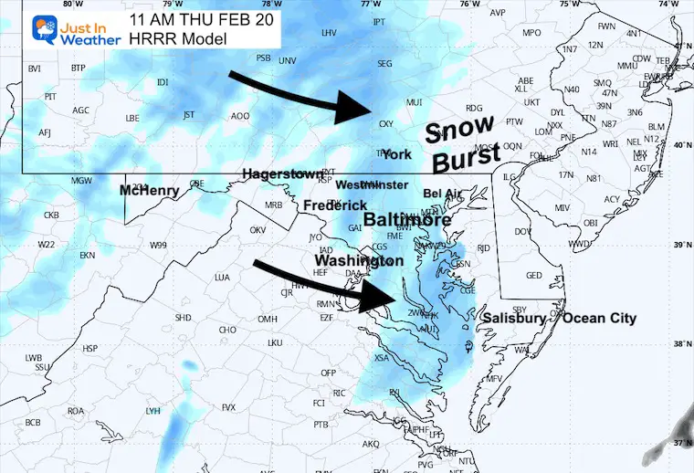
11 AM
Peak snow burst may be crossing metro areas and the Chesapeake Bay.
Noon
The snow band may cross Delmarva, while additional snow will persist in PA. It may ride the Northwest wind and continue for the region all afternoon.
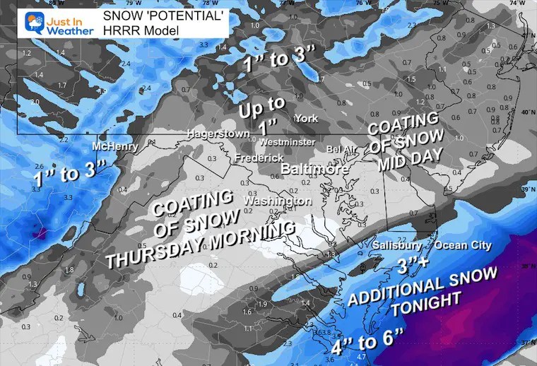
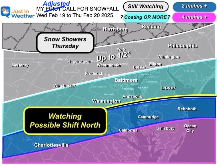
Suggested Snow Totals
ADDITIONAL FROM TONIGHT THROUGH THURSDAY
For simplicity, I am sticking with this HRRR Model today. In all honesty, anywhere in the advisory area can see between a coating and 1 inch of snow… This does include southern PA and perhaps farther east, and there will be an impact on roads midday for the rest of Delmarva.
REPEAT OF MY FORECAST FROM MONDAY
I left this the same on purpose. I put the focus for Thursday at 1/2 inch, but I would not be surprised to see places hit the 1 inch mark.
Faith in the Flakes
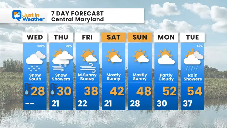
7 Day Forecast
Edge Of Polar Cold AND Southern Storm Through Thursday
Weekend: Storm Pattern Breaks!
Mild 50s Next Week
Subscribe for eMail Alerts
SNOW REPORTS THIS SEASON
Click on the maps for that full report.
February 11 Snow Report And Grade My Forecast
click here or the map for more

January 19 Snow Report

January 11 Snow Report

January 6 Snow Report

Previous Snow

ALSO SEE
Recent Snow Reports
La Nina Advisory January 2025
Full Report

MY WINTER OUTLOOK
My Winter Outlook Report

FITF Gear on Sale

In Case You Missed This
The Faith In The Flakes Dec 5 Origin Story

Please share your thoughts and best weather pics/videos, or just keep in touch via social media.
SCHEDULE A WEATHER BASED STEM ASSEMBLY
Severe Weather: Storm Smart October and next spring Winter Weather FITF (Faith in the Flakes): November To March Click to see more and send a request for your school.

THANK YOU:
Baltimore Magazine Readers Choice Best Of Baltimore
Maryland Trek 11 Day 7 Completed Sat August 10
We raised OVER $104,000 for Just In Power Kids – AND Still Collecting More
The annual event: Hiking and biking 329 miles in 7 days between The Summit of Wisp to Ocean City.
Each day, we honor a kid and their family’s cancer journey.
Fundraising is for Just In Power Kids: Funding Free Holistic Programs. I never have and never will take a penny. It is all for our nonprofit to operate.
Click here or the image to donate:

RESTATING MY MESSAGE ABOUT DYSLEXIA
I am aware there are some spelling and grammar typos and occasional other glitches. I take responsibility for my mistakes and even the computer glitches I may miss. I have made a few public statements over the years, but if you are new here, you may have missed it: I have dyslexia and found out during my second year at Cornell University. It didn’t stop me from getting my meteorology degree and being the first to get the AMS CBM in the Baltimore/Washington region. One of my professors told me that I had made it that far without knowing and to not let it be a crutch going forward. That was Mark Wysocki, and he was absolutely correct! I do miss my mistakes in my own proofreading. The autocorrect spell check on my computer sometimes does an injustice to make it worse. I also can make mistakes in forecasting. No one is perfect at predicting the future. All of the maps and information are accurate. The ‘wordy’ stuff can get sticky. There has been no editor who can check my work while writing and to have it ready to send out in a newsworthy timeline. Barbara Werner is a member of the web team that helps me maintain this site. She has taken it upon herself to edit typos when she is available. That could be AFTER you read this. I accept this and perhaps proves what you read is really from me… It’s part of my charm. #FITF


