Tuesday Night, February 17 2025
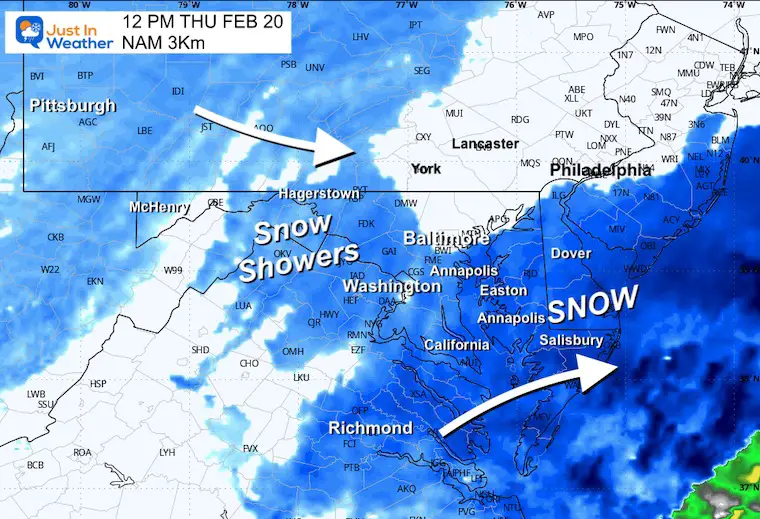
I know why the roads in Central Maryland have been treated with brine. There is more to this storm, and I still think the models are having trouble with the multiple parts and energy transfer. I am still interested in the north edge of steady snow to get close to Annapolis. As for the other places in metro Baltimore and along the PA line, there will be snow showers on Thursday that may coat the ground.
If you have a few minutes, please let me explain.
I can almost hear some people through this screen say to give this up already. Ha! There is going to be a strong snowstorm in the Mid-Atlantic, even if it favors farther southern parts of my normal forecast area. It is not the Nor’easter it looked like last Friday, but it is going to have a big impact along its path.
There is an academic process here, and I like to bring you along as best I can to show you some of what I am seeing.
I do agree that many forecasters have become too reliant on computer models. It is easy to show their plots and use their maps. I still DO NOT believe it’s a good idea to show snow totals more than 3 days before a storm. I also do not do the differential equations I learned in college, but I have a working knowledge of the models and ongoing study of both strengths and weaknesses.
My focus in the last day has been on the NAM Model—first the lower 12K resolution and now its short-range, higher resolution 3 Km cousin. Do you remember that burst of snow and sleet in Central Maryland and Southern Pennsylvania that hit midday Saturday? The NAM 3 Km was the model that called it one day before, while the infamous European Model had nothing but later rain.
LAST FRIDAY: Here is my post for Saturday
LAST SATURDAY Snow And Sleet Verified
Back to today:
This Model has been the outlier, showing the farthest north push with the band of snow. I see the pivotal location to be NEAR Annapolis. The steady snow and heavier snow will fall nearby and to the south. Places to the north are more like to get snow showers that could coat the ground on Thursday. That is the back piece of energy that just missed lining up for the Big Kahuna.
Let me get this out of the way…
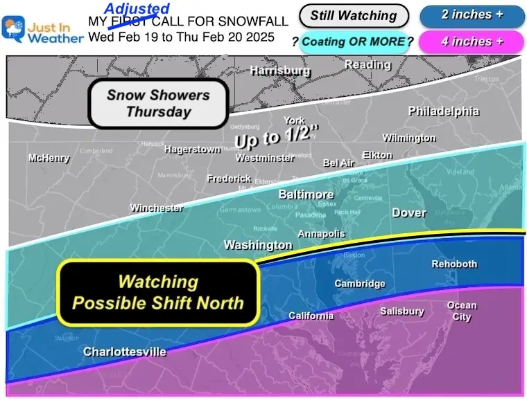
My Updated Call For Snowfall
I only made a slight adjustment to my first call map and left it easy to identify… The wider range of snow showers on the north end.
I still below there will be a pivotal spot very close to Annapolis.
Winter Storm Warning and Advisory: From The National Weather Service
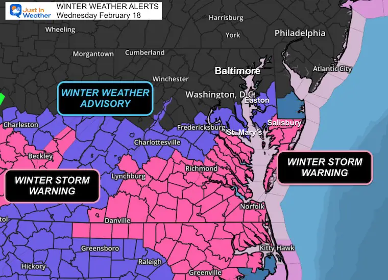
Suggested Snow Totals
I have a wide range of maps in this report. But I wanted to show you what I posted on social media this afternoon for comic relief.
The National Weather Service made one map with a very wide range that anointed Ocean City, MD, with a range of 1 to 10 inches. I know we can narrow this down better than that… It does highlight the potential error on the low and high end with a sharp gradient of steady snow.
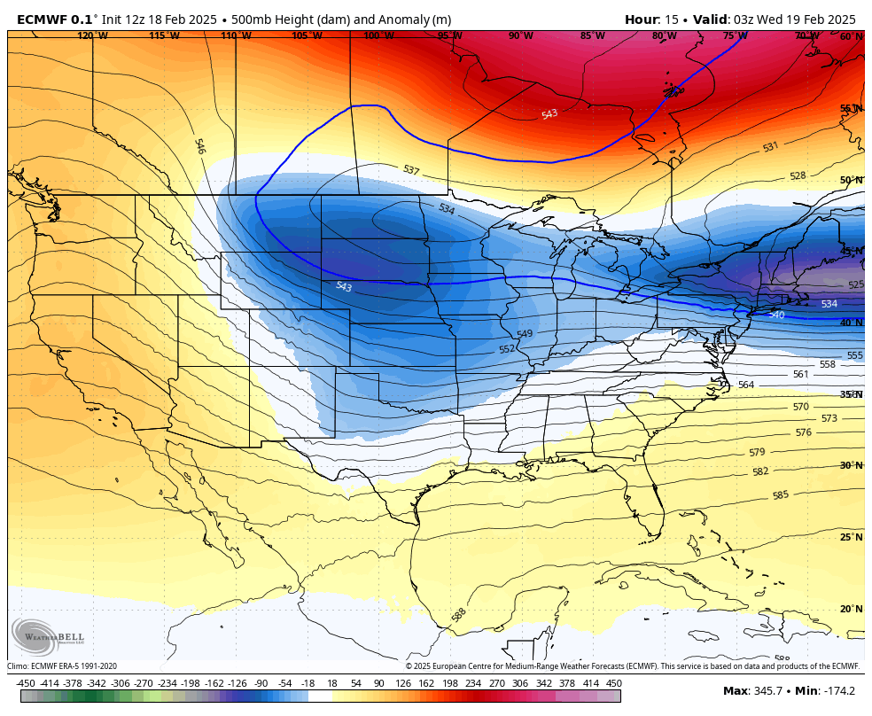
Jet Stream Forecast Tonight To Thursday Night
The upper-level energy that will help invigorate the surface storm will be trailing behind and passing over Maryland on Thursday. This setup is what pushes the track south AND will keep unstable air in place to drop snow showers for inland areas as this arrives.
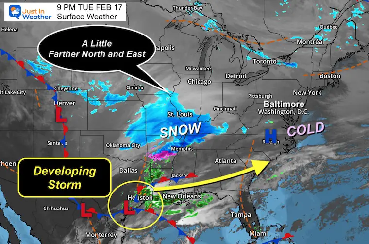
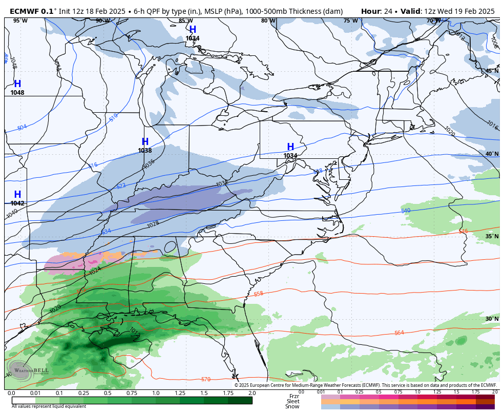
Set Up Tuesday Night: Surface Weather
When I compared this to the ECWMF Model at this time, I noticed the snow on the North edge in Iowa and the East edge on Kentucky are farther than forecast. This is just a signal of some subtle errors in the short range.
Surface Weather Forecast Wednesday Morning To Thursday Afternoon
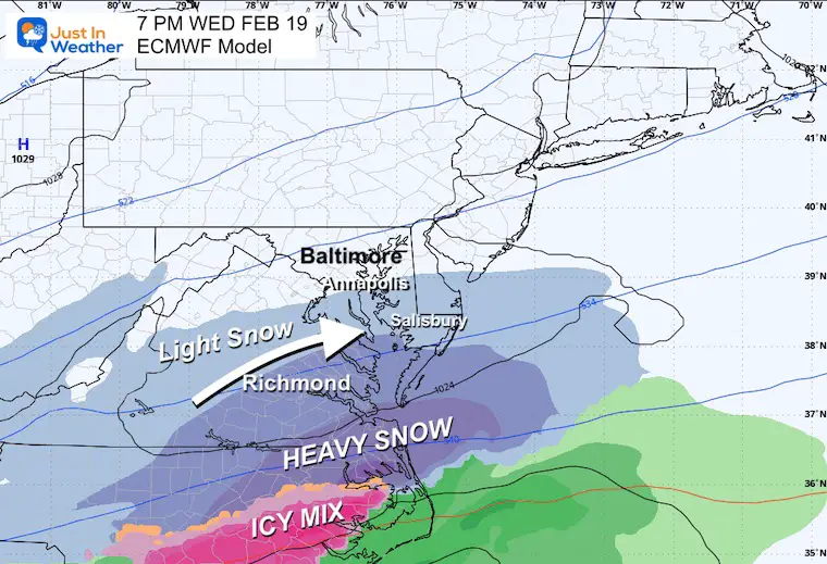
ECMWF Model
Tracks the main snow across Southeast Virginia. I need to state that the intermediate model run this afternoon had shifted north of this track and still not enough to match the surface map above.
Wednesday Night Snapshot
This shows the edge of light, steady snow near Annapolis. I need to point out that in two storms this year, the ECMWF had the snow too far south. This model is good but not always the best.
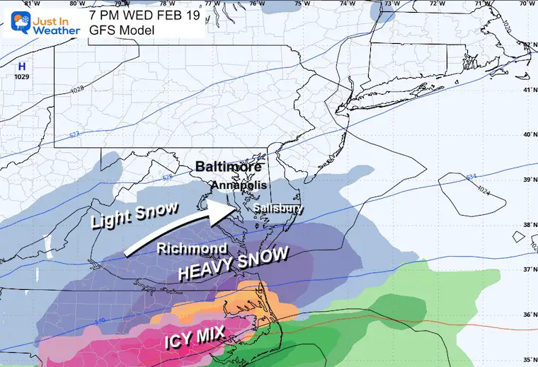
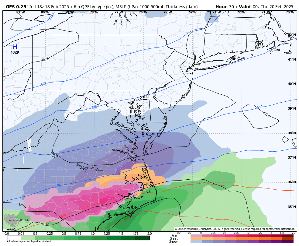
GFS Model
The subtlety here is that the steady, heavy snow is farther north, even though the north edge is south of Annapolis. But wait…
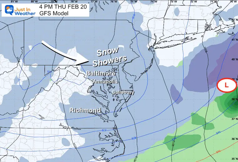
GFS Model Thursday Afternoon
This shows the second part, with the upper-level low bringing snow showers to Central Maryland and Pennsylvania. It is not the main storm, but it can still affect the roads.
GFS Model Animation Wednesday Night to Thursday Morning
This may help show the two separate parts of this storm. While the Thursday afternoon snow showers will be lighter, that trailing behind is what kept the original major storm from forming.
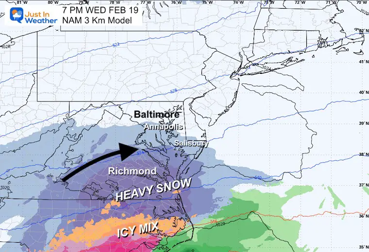
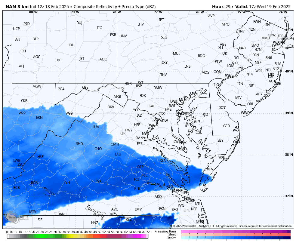
Back To The NAM 3Km Model
This is the model I showed that did the best job last weekend. Here, it brings the steady snow CLOSER to Annapolis by Thursday morning. It is a feature for Southern Maryland I still feel needs close attention.
Wednesday Night
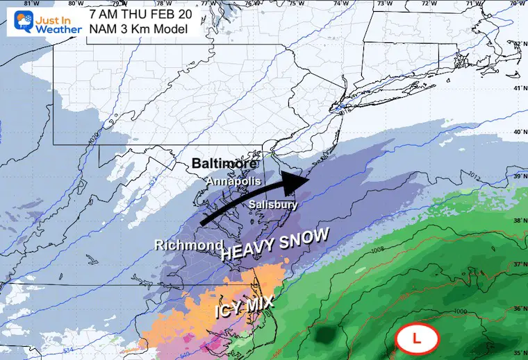
Thursday Morning
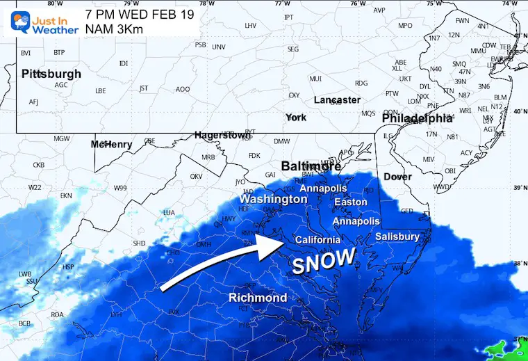
Animation 7 PM Wed to 12 PM Thu
Here we can see the steady snow staying close AND THEN the snow showers arriving with the upper level Low from the West.
CLOSER VIEW
Radar Simulation ‘Suggestion’
12 PM Wed to Midnight
A closer look at the potential track of snow.
With the air cold and dry, there may be VIRGA on the northern edge.
7 PM Wednesday Snapshot
Thursday Radar Simulation ‘Suggestion’
Midnight to Noon
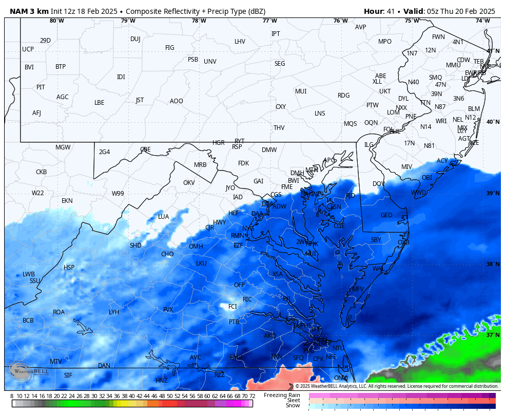
7 AM Thursday Snapshot
Annapolis is still near the pivot point for steady snow.
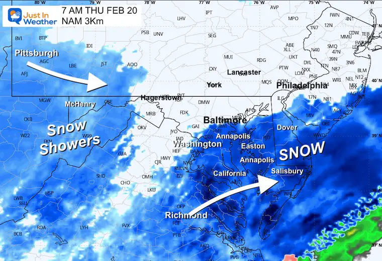
Noon Snapshot
The introduction of light snow or snow showers with the Upper-Level Low from the West may bring a coating of snow for more inland areas.
Model Snow Total Potential Forecast
Here’s the crazy part…
Note: I am using the 10:1 standard ratio. If we do get snow and stay in the lower 20s, the Kuchera Method will need to be applied to account for dry snow and the ‘Fluff Factor.’
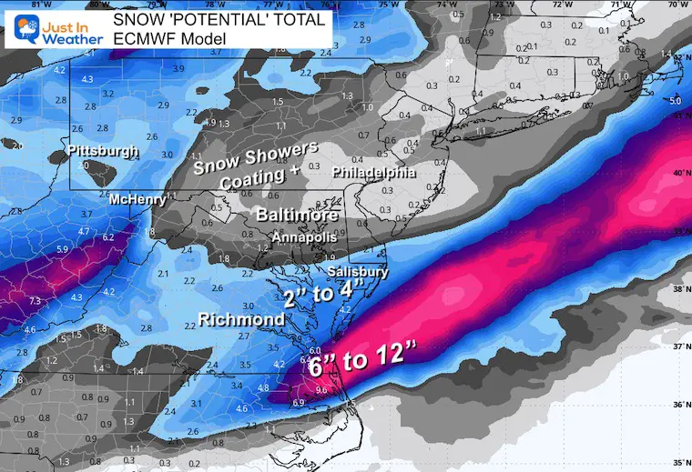
ECMWF Model
2” to 4” for Extreme Southern Maryland AND the Lower Eastern Shore.
1” or close to it for Annapolis, and a coating to 1/2 inch farther inland.
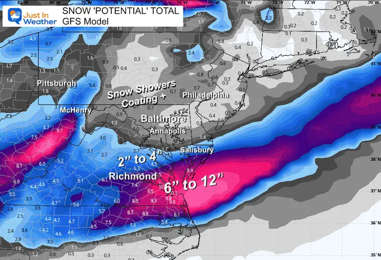
GFS Model
Slightly more for The Lower Eastern Shore of Maryland and higher totals for Southeast Virginia.
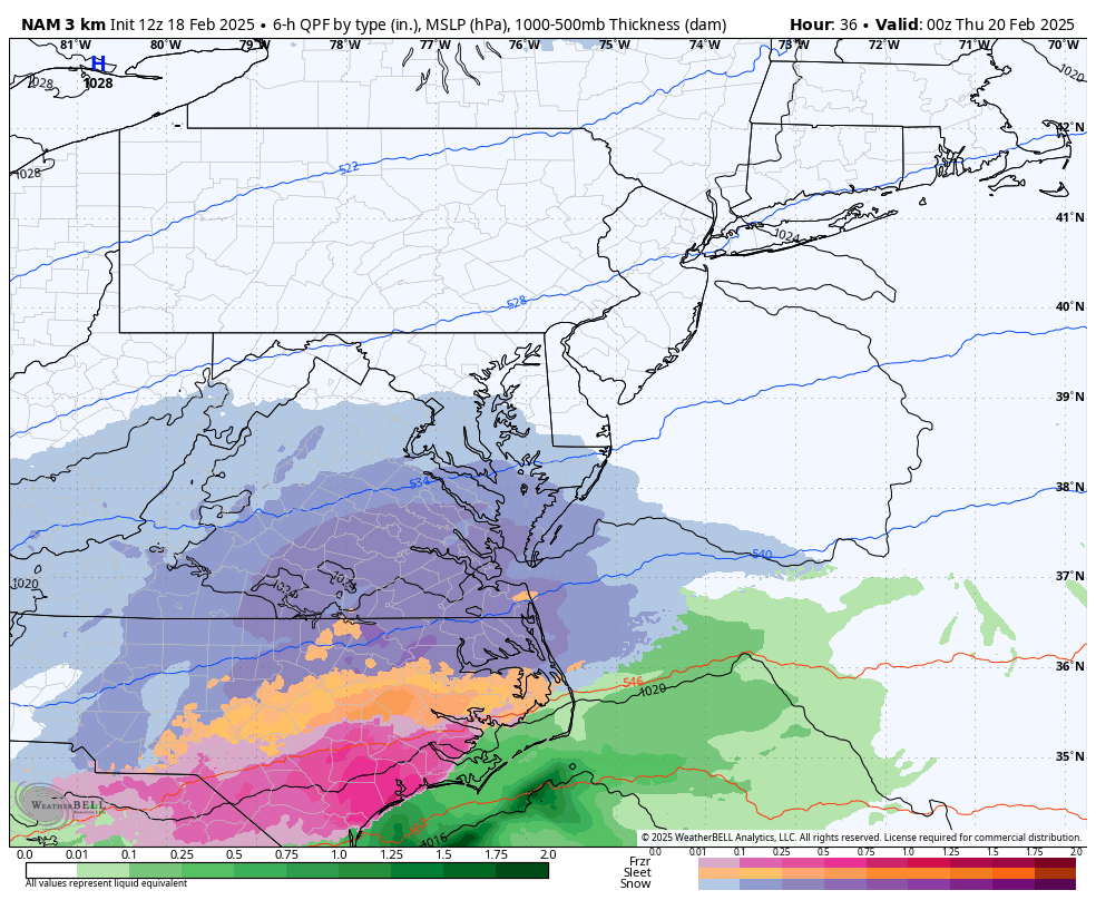
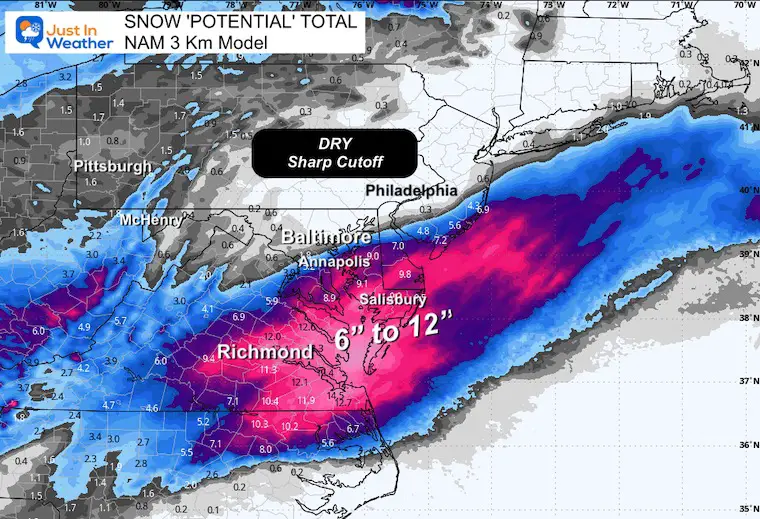
NAM 3Km
This brings significant now close to Annapolis near the sharp cut-off…
CLOSER LOOK
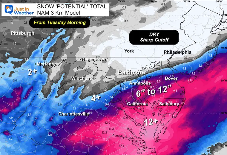
NAM 3Km From This Morning
This matches the same model run time as the others….
SHARP CUT OFF
4.9” for Annapolis and 0.4” for Baltimore, with nothing in the city.
The show of 6 to 12 inches of snow across Southern Maryland and The Lower Eastern Shore is a shift of early 100 miles for the storm northward.
I can’t fully buy this and you will see it changed a lot in the next run.
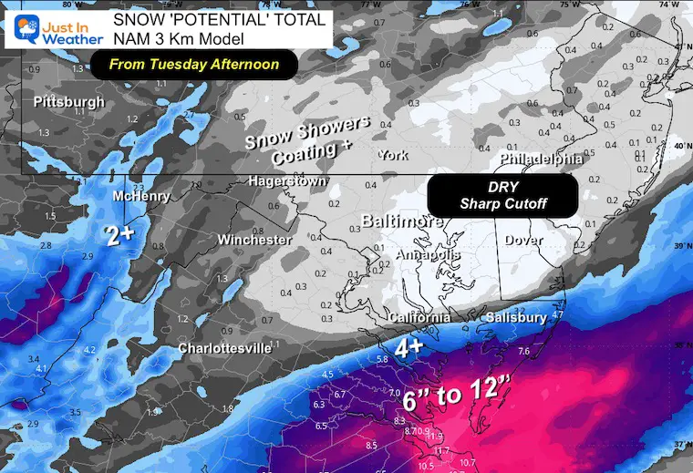
NAM 3Km From This Afternoon
I do not usually trust intermediate model runs between main balloon launch times.
This afternoon, the adjusted plot made an abrupt adjustment of that cut-off line to the south.
It changed the 6” to 12” inch zone in Maryland to 2” to 4”. I believe there was an algorithm to consider the other global models that caused the shift.
I can buy this either…. But something in between.
Repeat Of My First Call
I only made a slight adjustment to my first call map and left it easy to identify… The wider range of snow showers on the north end.
I still below there will be a pivotal spot very close to Annapolis.
This may not have a big impact on much of my regular forecast home area, but it is still a close call and worth watching. These computer models are guidance and not perfect. I will shift to a more real-time assessment of the development in my next report and on Social Media all day.
Faith in the Flakes
Subscribe for eMail Alerts
SNOW REPORTS THIS SEASON
Click on the maps for that full report.
February 11 Snow Report And Grade My Forecast
click here or the map for more

January 19 Snow Report

January 11 Snow Report

January 6 Snow Report

Previous Snow

ALSO SEE
Recent Snow Reports
La Nina Advisory January 2025
Full Report

MY WINTER OUTLOOK
My Winter Outlook Report

FITF Gear on Sale

In Case You Missed This
The Faith In The Flakes Dec 5 Origin Story

Please share your thoughts and best weather pics/videos, or just keep in touch via social media.
SCHEDULE A WEATHER BASED STEM ASSEMBLY
Severe Weather: Storm Smart October and next spring Winter Weather FITF (Faith in the Flakes): November To March Click to see more and send a request for your school.

THANK YOU:
Baltimore Magazine Readers Choice Best Of Baltimore
Maryland Trek 11 Day 7 Completed Sat August 10
We raised OVER $104,000 for Just In Power Kids – AND Still Collecting More
The annual event: Hiking and biking 329 miles in 7 days between The Summit of Wisp to Ocean City.
Each day, we honor a kid and their family’s cancer journey.
Fundraising is for Just In Power Kids: Funding Free Holistic Programs. I never have and never will take a penny. It is all for our nonprofit to operate.
Click here or the image to donate:

RESTATING MY MESSAGE ABOUT DYSLEXIA
I am aware there are some spelling and grammar typos and occasional other glitches. I take responsibility for my mistakes and even the computer glitches I may miss. I have made a few public statements over the years, but if you are new here, you may have missed it: I have dyslexia and found out during my second year at Cornell University. It didn’t stop me from getting my meteorology degree and being the first to get the AMS CBM in the Baltimore/Washington region. One of my professors told me that I had made it that far without knowing and to not let it be a crutch going forward. That was Mark Wysocki, and he was absolutely correct! I do miss my mistakes in my own proofreading. The autocorrect spell check on my computer sometimes does an injustice to make it worse. I also can make mistakes in forecasting. No one is perfect at predicting the future. All of the maps and information are accurate. The ‘wordy’ stuff can get sticky. There has been no editor who can check my work while writing and to have it ready to send out in a newsworthy timeline. Barbara Werner is a member of the web team that helps me maintain this site. She has taken it upon herself to edit typos when she is available. That could be AFTER you read this. I accept this and perhaps proves what you read is really from me… It’s part of my charm. #FITF


