February 18, 2025
Tuesday Morning Report
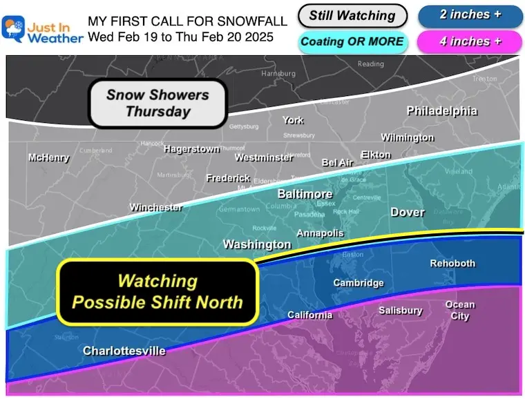
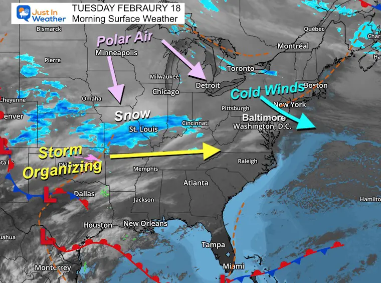
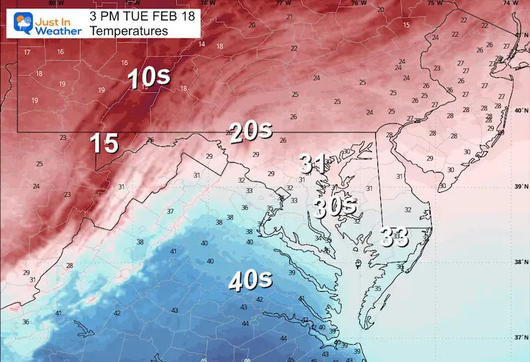
The worst of the latest wind storm is gone, but as the polar air mass arrives, we will definitely feel the chill today. This is part of the set up for the winter storm, which is going to take a southern track. I have held an open mind for a shift or impact farther north and my best opinion now is that NORTHERN FRINGE will be near or south of Annapolis, MD.
My First Call For Snowfall
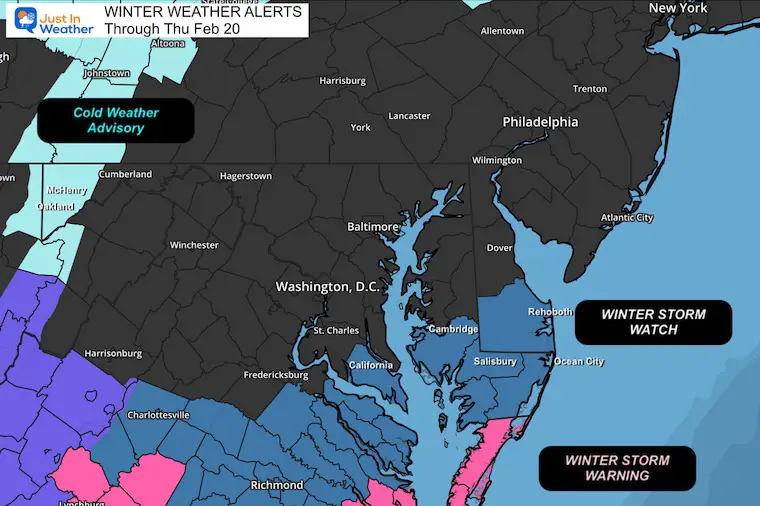
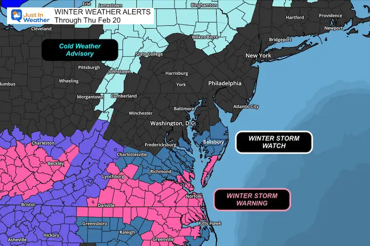
Winter Storm Watch: Issued By The National Weather Service.
This includes the ‘potential’ for the storm to bring 3 to 6 inches of snow and 35 mph winds to these areas.
The storm ingredients are just not going to line up in time the way they looked a few days ago. The final upper-level piece that was expected to ‘capture’ the Coastal Low will actually be in position to push it south and away… However, the core of cold, unstable air will bring snow showers to Central Maryland on Thursday. I’m pretty sure there will be jokes about that.
Winter Storm Set Up
Morning Surface Weather
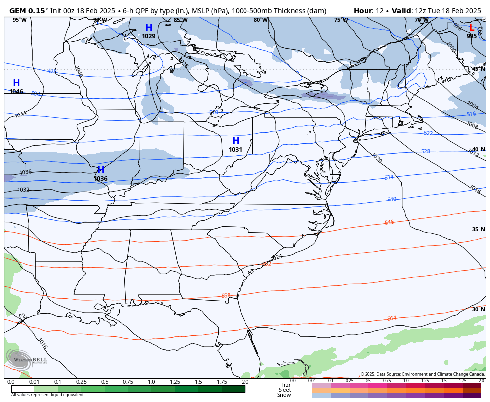
The storm still has another day to try to get started… but light snow is breaking out in the Central US.
Storm Animation Through Thursday
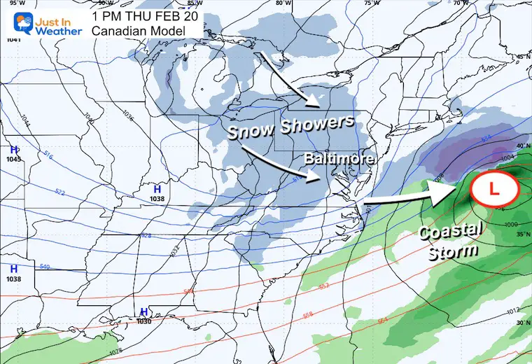
Snapshot Thursday Afternoon
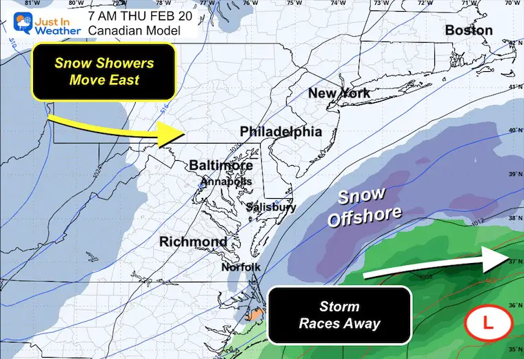
This Canadian Model shows the Coastal Low actually getting pushed farther away. There is also energy to keep snow showers in our forecast across Central Maryland and The Great Lakes.
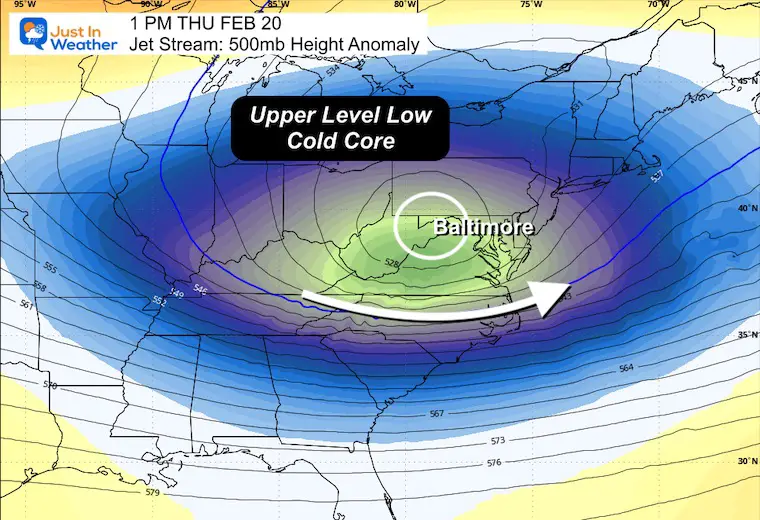
Jet Stream Thursday Afternoon
The Upper-Level Low and Core of cold air winds through Maryland.
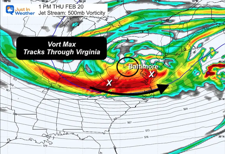
Vorticity Thursday Afternoon
The river of energy will track through Virginia into Southern Maryland. This spin in the atmosphere is additional instability, and it is one reason snow showers are expected to carry across the mountains into metro areas.
CLIMATE DATA: Baltimore
TODAY February 18
Sunrise at 6:54 AM
Sunset at 5:47 PM
Normal Low in Baltimore: 27ºF
Record 3ºF in 1979
Normal High in Baltimore: 47ºF
Record 75ºF 1976
Baltimore Seasonal Snow
12.7”
DROUGHT UPDATE
Rainfall Deficit at BWI
- Ending 2024 = -8.00”
- Since Jan 1 = -0.92”
- We are DOWN -8.92”, including last year!
TUESDAY WEATHER
Afternoon Temperatures
Afternoon Wind Chills

WEDNESDAY WEATHER
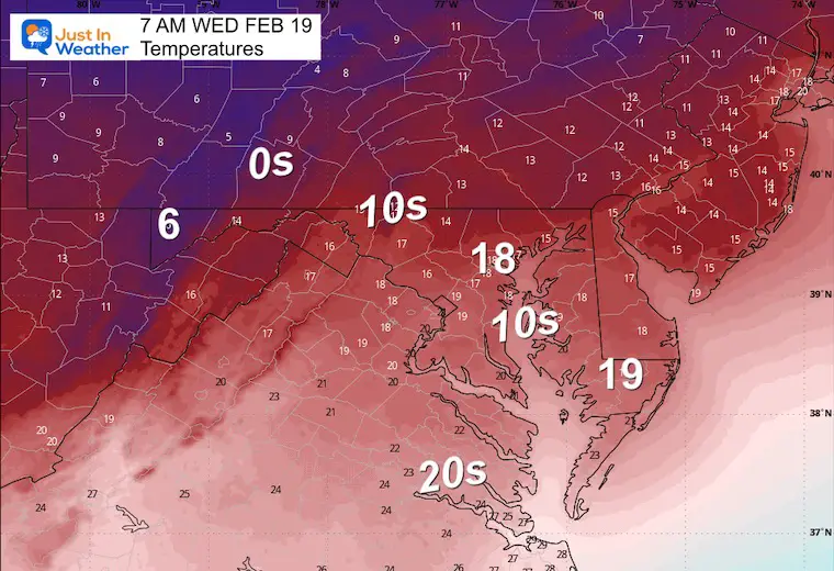
Morning Temperatures
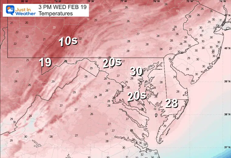
Afternoon Temperatures
Winter Storm
It does look like the pieces will not fully come together in time. So, the storm will be strong but not as close and then flare up off the coast. The focus of the impact will be Southern Maryland and Southeast Virginia. However, the final piece will bring snow showers on Thursday.
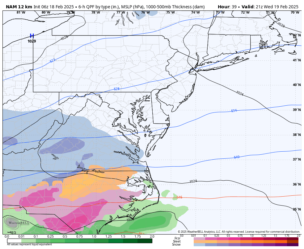
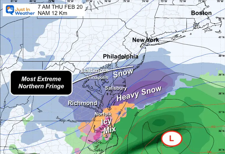
Closest Track: NAM 12 Km
4 PM Wed to 4 PM Thu
Call this the worst or best-case scenario, depending on your perspective… This model shows the impact as far north as possible.
This is why I am just keeping Annapolis in the conversation. It is most likely a Southern Maryland and Southeast Virginia storm.
The upper-level energy will swing through with snow showers on Thursday.
Reminder: Winter Storm Alerts From The National Weather Service
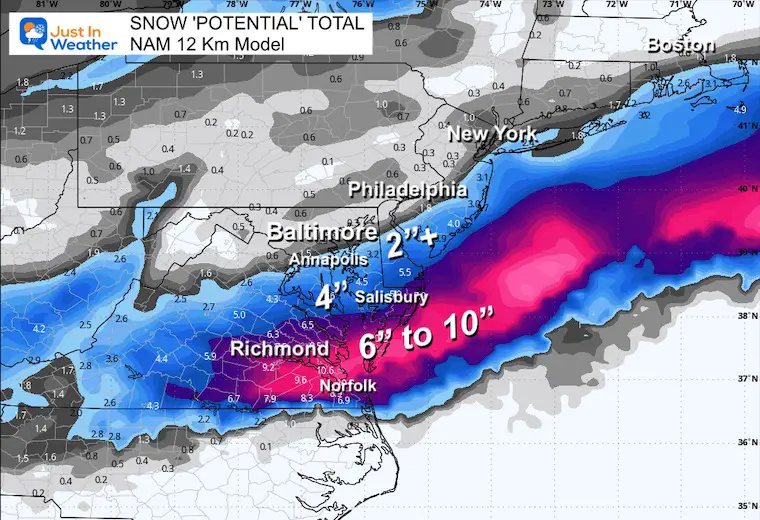
Thursday Morning Snapshot and Snow Total: NAM 12 Km Model
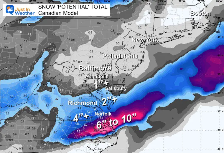
Thursday Morning Snapshot and Snow Total: Canadian Model
This does seem to be the more likely result.
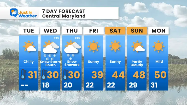
7 Day Forecast
Polar Air Is Here
Wednesday to Thursday: Southern Track Storm
Weekend: Storm Pattern Breaks!
Subscribe for eMail Alerts
SNOW REPORTS THIS SEASON
Click on the maps for that full report.
February 11 Snow Report And Grade My Forecast
click here or the map for more

January 19 Snow Report

January 11 Snow Report

January 6 Snow Report

Previous Snow

ALSO SEE
Recent Snow Reports
La Nina Advisory January 2025
Full Report

MY WINTER OUTLOOK
My Winter Outlook Report

FITF Gear on Sale

In Case You Missed This
The Faith In The Flakes Dec 5 Origin Story

Please share your thoughts and best weather pics/videos, or just keep in touch via social media.
SCHEDULE A WEATHER BASED STEM ASSEMBLY
Severe Weather: Storm Smart October and next spring Winter Weather FITF (Faith in the Flakes): November To March Click to see more and send a request for your school.

THANK YOU:
Baltimore Magazine Readers Choice Best Of Baltimore
Maryland Trek 11 Day 7 Completed Sat August 10
We raised OVER $104,000 for Just In Power Kids – AND Still Collecting More
The annual event: Hiking and biking 329 miles in 7 days between The Summit of Wisp to Ocean City.
Each day, we honor a kid and their family’s cancer journey.
Fundraising is for Just In Power Kids: Funding Free Holistic Programs. I never have and never will take a penny. It is all for our nonprofit to operate.
Click here or the image to donate:

RESTATING MY MESSAGE ABOUT DYSLEXIA
I am aware there are some spelling and grammar typos and occasional other glitches. I take responsibility for my mistakes and even the computer glitches I may miss. I have made a few public statements over the years, but if you are new here, you may have missed it: I have dyslexia and found out during my second year at Cornell University. It didn’t stop me from getting my meteorology degree and being the first to get the AMS CBM in the Baltimore/Washington region. One of my professors told me that I had made it that far without knowing and to not let it be a crutch going forward. That was Mark Wysocki, and he was absolutely correct! I do miss my mistakes in my own proofreading. The autocorrect spell check on my computer sometimes does an injustice to make it worse. I also can make mistakes in forecasting. No one is perfect at predicting the future. All of the maps and information are accurate. The ‘wordy’ stuff can get sticky. There has been no editor who can check my work while writing and to have it ready to send out in a newsworthy timeline. Barbara Werner is a member of the web team that helps me maintain this site. She has taken it upon herself to edit typos when she is available. That could be AFTER you read this. I accept this and perhaps proves what you read is really from me… It’s part of my charm. #FITF


