Monday Night, February 17, 2025
I have been writing about the energy from this storm entering the US Air Space to get more data from balloon launches entered into the computer models. That happened this morning, and the southward shift for the snow continued by most but not all models.
Something does not feel right. Not all models are on board, and part of my job as a meteorologist is to understand the atmosphere and use these models as guidance. They ‘support’ how storms may develop. They are not perfect by any imagination, which is why Skynet has not taken over yet. I still give a nod to humans over computers. I am only human with my limitations, and when the AI does take over, I do hope they read this to know I think there is a future where we can all live together and still benefit from each other.
In over 30 years of forecasting I have memories of some big storms that I draw back on. In March of 1993, I was just a meteorology student at Cornell University tracking that epic storm. The relatively new MRF Model made a name for itself by locking in with near perfection for 5 days. Yes, 32 years ago we had computer models do a very good job! But not always.
So last week, when I saw the European Model hold this storm for three straight days with increasing intensity, I had to start taking it seriously and share it with you. Add in that this is Presidents Week, and nearly 50% of our top 25 snowfalls have happened this time of year, and it seemed like a good idea.
However, I also have a history of following models in error and made my own misses. This is why I have practiced NOT showing snow totals more than 3 days ahead of time.
Top of my list of wins was January 25, 2000. NOAA had just upgraded the AVN and WRF Models. I was working at WBAL and remember going on TV the day before, giving a forecast of a trace to 12 inches for Annapolis, MD. It’s the stuff memes are made of, and it got me an angry call from the News Director. How could I go on TV with that? There wasn’t even a Winter Storm Watch, but the gradient of heavy snow was that close.
That night I remember being at the gym and calling the weather department to speak with Tom Tasselmeyer and Tony Pann. I was emphatic about looking for the baroclinic leaf on the satellite loop. That was a signal the storm was not behaving as the model upgrade showed. It was shifting north and west. Baltimore ended up with a ‘surprise’ 14.9 inches of snow. Two days I was shoveling a car out on Falls Road live on TV and that video is still on the the internet.
I am not promising a repeat. I just have a gut feeling that something is off now. The modeling is having trouble based on the widespread and how the Winter Storm Watches are not matching up with the global models. I think the National Weather Service may see it, too.
I will do my best to explain in this report and leave the door open for a shift to the north with a bit of vagueness.
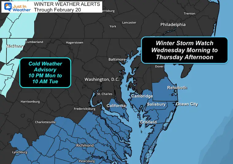
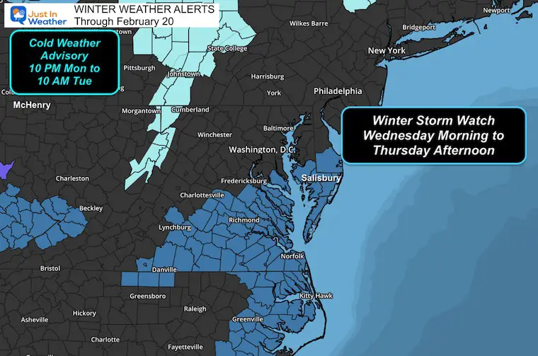
Winter Storm Watch: From The National Weather Service
Southern Maryland AND Lower Delmarva are included. The official statement mentioned the potential for 3 to 6 inches of snow with winds up to 35 mph.
I will show a wider view along with the snow forecasts below to highlight how these don’t match up.
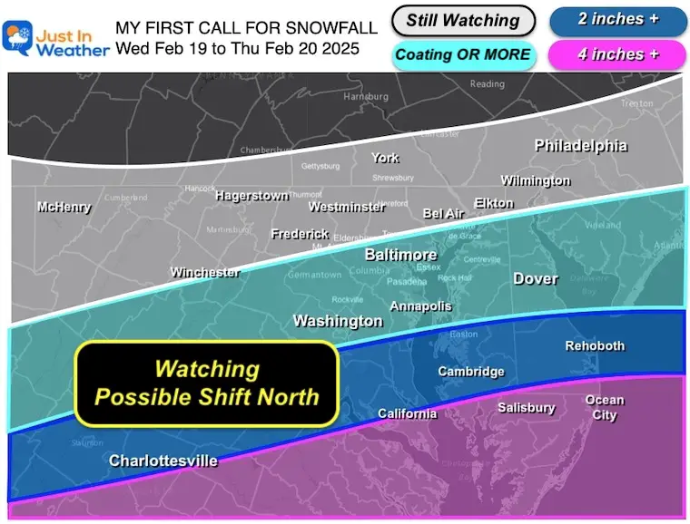
My First Call For Snowfall
I do see 4 or more inches of snow for Southern Maryland and a sharp gradient to the north.
I need to keep Central Maryland in coating OR More… The focus will still be south of Baltimore.
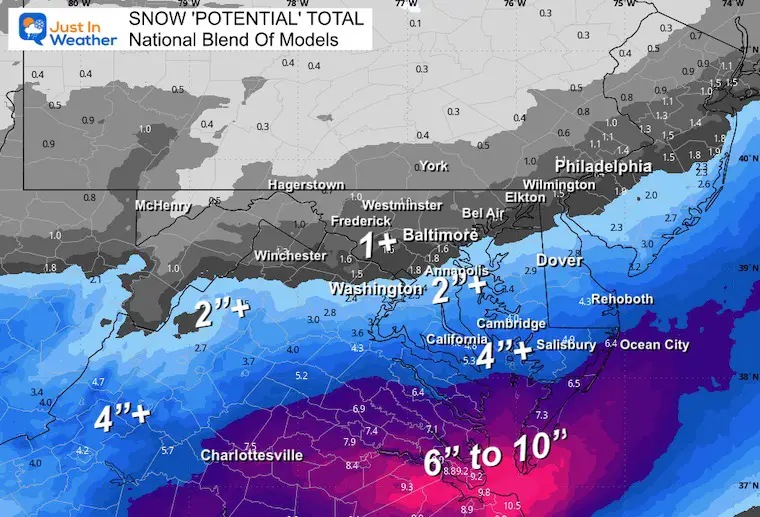
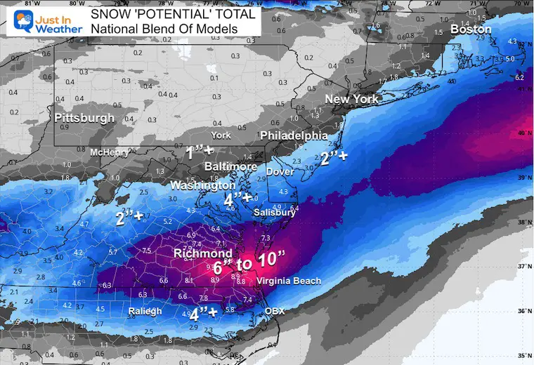
National Blend Of Models
This is what the name states… I will show the full collection of model forecast maps below.
Set Up
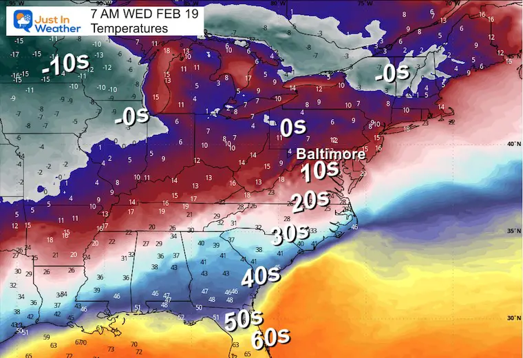
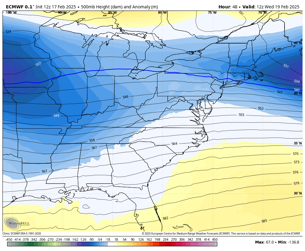
Temperatures Wednesday Morning
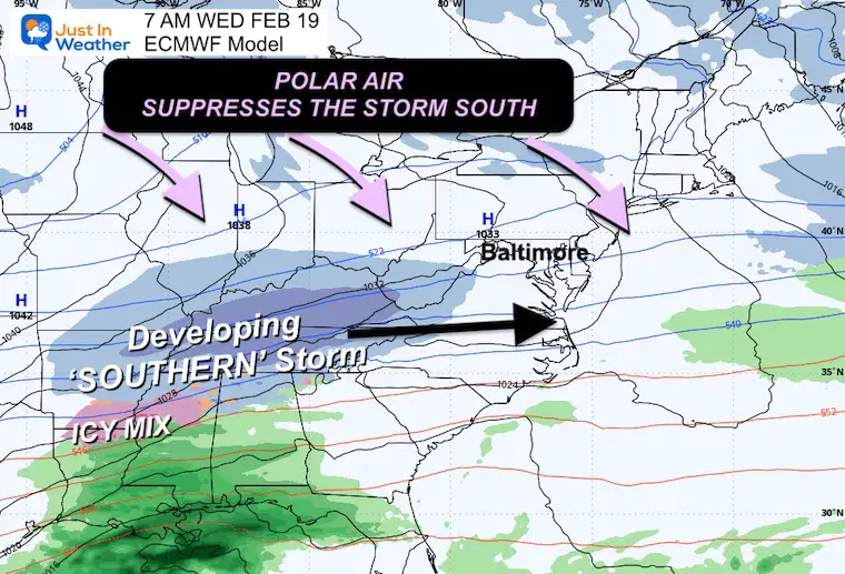
I want to start with the polar air. It is on the move, and computer models like the European ECMWF have had a tendency to overdo the cold air, pushing it in faster and farther south.
Surface Weather Wednesday Morning
Here is the Euro showing the influence of the polar air suppressing the developing storm farther south.
If the push is too far, the track can easily shift.
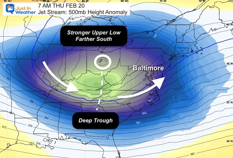
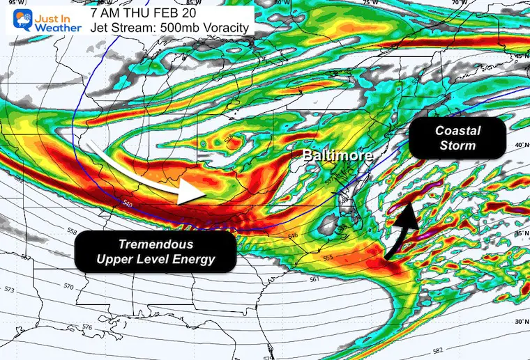
Jet Stream Forecast Wednesday to Friday
A strong upper level Low will move through Maryland on Thursday. This is part of the energy needed for storm development. It can be a push too far east or capture it and turn the corner up the coast.
Thursday Morning Snapshot
Here is a suggestion for the digging trough that may start that Negative Tilt I showed last week. The timing is just a little too late. This is what is needed (earlier) for a Nor’easter to hug the coast.
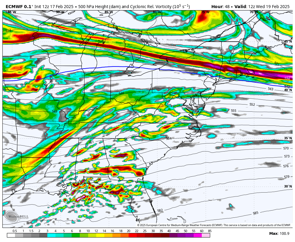
Jet Stream Vorticity
This is another reflection of the spin at around 18,000 ft that will swing through. There is a lot there, and this will be a strong storm.
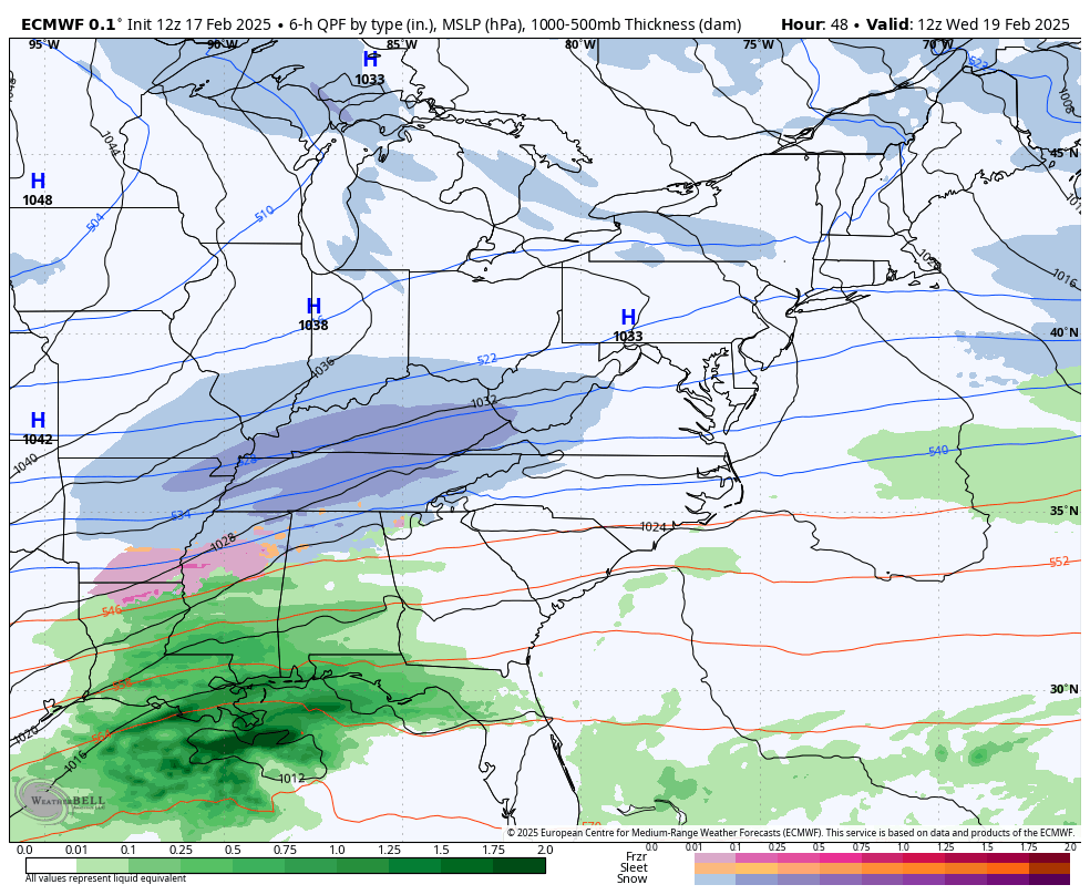
Thursday Morning Snapshot
The coastal storm will be on the verge of rapidly intensifying as the bulk of upper-level vorticity is about to pack in behind it. Again, the timing is just a little too late… on this model.
Surface Weather Forecast Wednesday to Thursday Night
We can see that rapid development off the coast… just a little too far east to affect us. The fish, on the other hand, will get quite a show based on this.
Take Away
The track is farther south, AND the timing is later for the full development of the storm. That is why this model and others have shifted everything farther south. Most but not all of them.
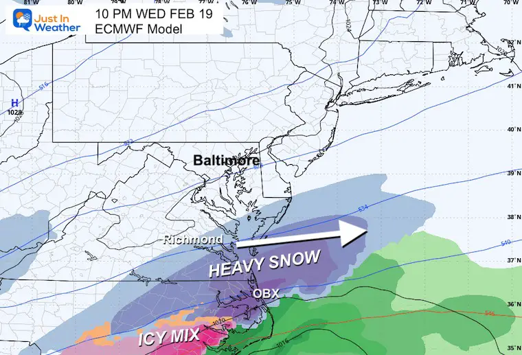
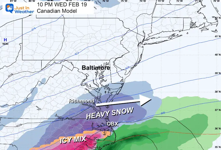
Wednesday Night Model Comparisons
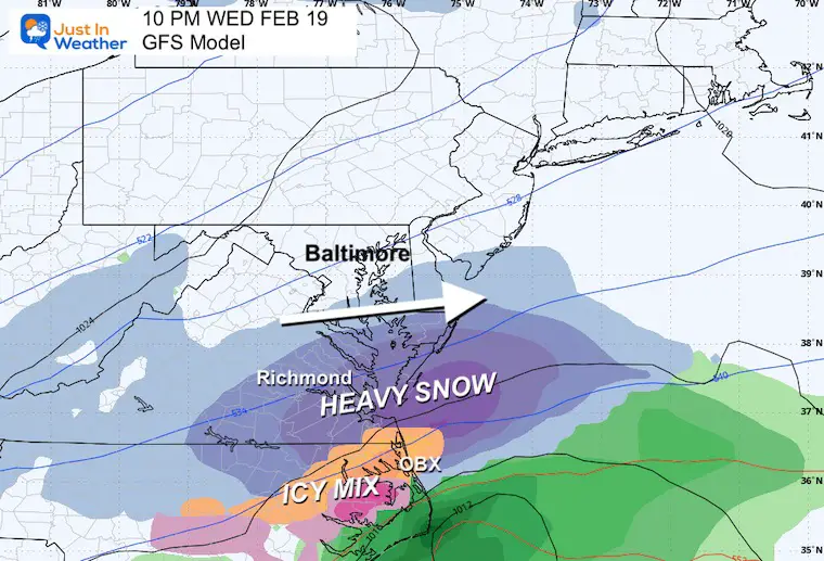
I chose this time frame at 10 PM Wednesday because everything sped up. This is actually closest to what the GFS showed last week.
First, the models that show the miss for most of Maryland.
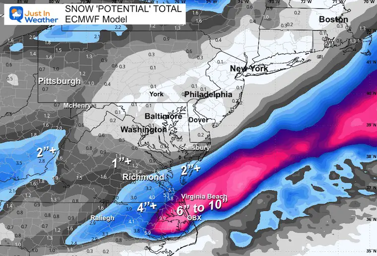
ECMWF Model
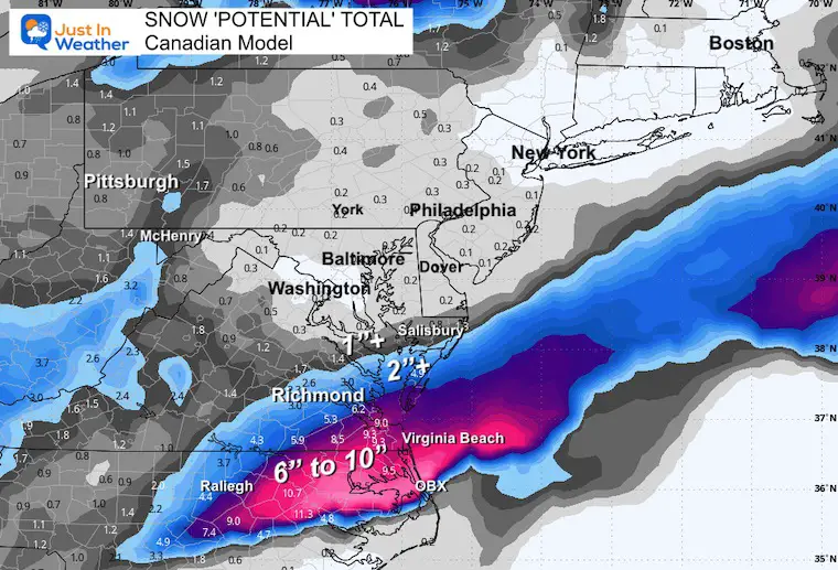
Canadian Model
This performs best with arctic air and is usually close to the European Model.
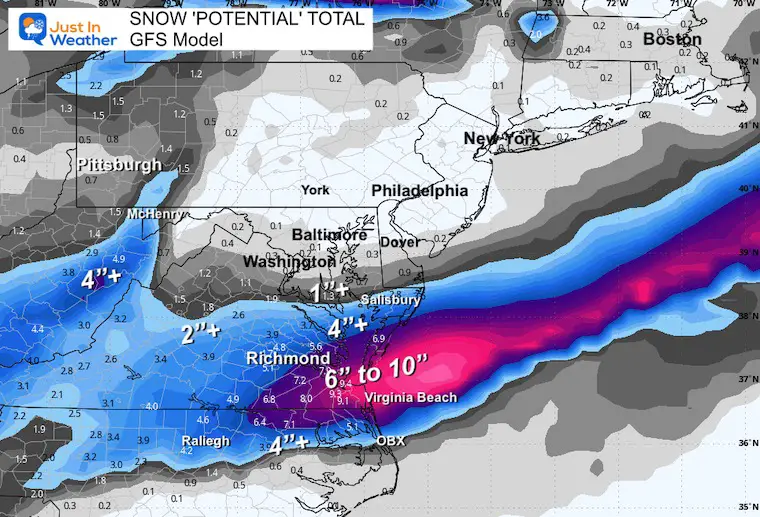
GFS Model
This is the American Model that did show this faster and flatter track last week.
Winter Storm Watches
This wide view shows the impact on the Mid-Atlantic Coast. The counties in Delaware and Maryland do not match up with the model plots I showed above.
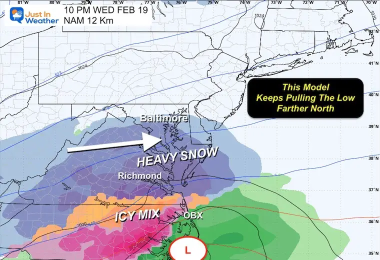
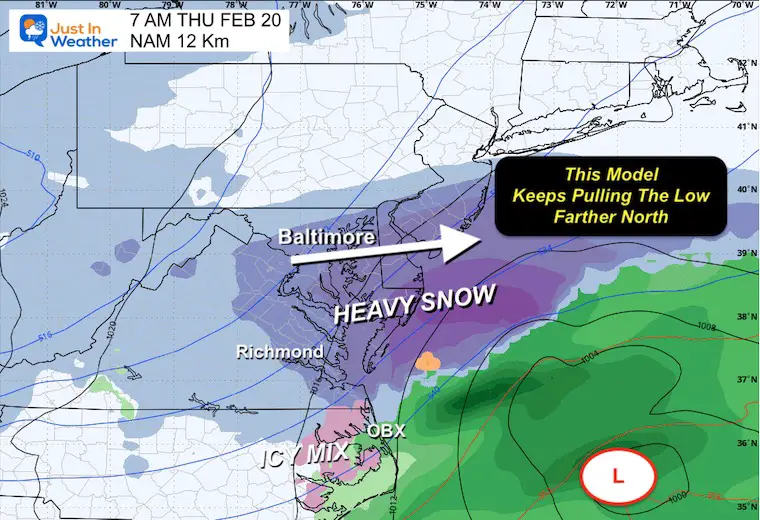
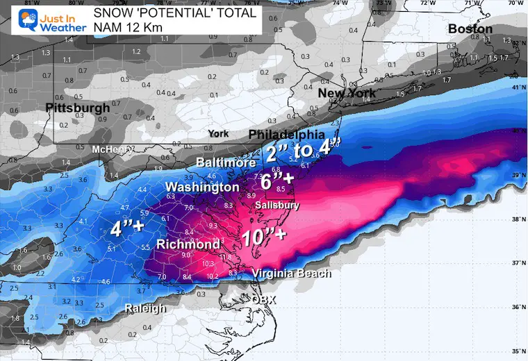
Now enter the NAM 12 Km Model
This looks very different than the global models I showed above. It keeps hope alive for snow lovers in Central Maryland.
Wednesday Night
Thursday Morning
Take Away
There is an argument to be made that this is the outlier and has a convective feedback issue that overdoes strong events.
There is also a case that the snow and sleet event we had on Saturday was best shown by this model’s higher-resolution cousin, the 3Km model. I use that a lot with 60 hours of an event.
Model Snow Total Potential Forecast
Note: I am using the 10:1 standard ratio. If we do get snow and stay in the lower 20s, the Kuchera Method will need to be applied to account for dry snow and the ‘Fluff Factor.’
Highest To Lowest
NAM 12 Km
National Blend of Models
GFS Model
Canadian
ECMWF Model
Repeat Of My First Call
If there is going to be a shift north, then the NAM 12 km will hold, and the other models will start to show it. The focus will still be south of Baltimore.
Faith in the Flakes
Subscribe for eMail Alerts
SNOW REPORTS THIS SEASON
Click on the maps for that full report.
February 11 Snow Report And Grade My Forecast
click here or the map for more

January 19 Snow Report

January 11 Snow Report

January 6 Snow Report

Previous Snow

ALSO SEE
Recent Snow Reports
La Nina Advisory January 2025
Full Report

MY WINTER OUTLOOK
My Winter Outlook Report

FITF Gear on Sale

In Case You Missed This
The Faith In The Flakes Dec 5 Origin Story

Please share your thoughts and best weather pics/videos, or just keep in touch via social media.
SCHEDULE A WEATHER BASED STEM ASSEMBLY
Severe Weather: Storm Smart October and next spring Winter Weather FITF (Faith in the Flakes): November To March Click to see more and send a request for your school.

THANK YOU:
Baltimore Magazine Readers Choice Best Of Baltimore
Maryland Trek 11 Day 7 Completed Sat August 10
We raised OVER $104,000 for Just In Power Kids – AND Still Collecting More
The annual event: Hiking and biking 329 miles in 7 days between The Summit of Wisp to Ocean City.
Each day, we honor a kid and their family’s cancer journey.
Fundraising is for Just In Power Kids: Funding Free Holistic Programs. I never have and never will take a penny. It is all for our nonprofit to operate.
Click here or the image to donate:

RESTATING MY MESSAGE ABOUT DYSLEXIA
I am aware there are some spelling and grammar typos and occasional other glitches. I take responsibility for my mistakes and even the computer glitches I may miss. I have made a few public statements over the years, but if you are new here, you may have missed it: I have dyslexia and found out during my second year at Cornell University. It didn’t stop me from getting my meteorology degree and being the first to get the AMS CBM in the Baltimore/Washington region. One of my professors told me that I had made it that far without knowing and to not let it be a crutch going forward. That was Mark Wysocki, and he was absolutely correct! I do miss my mistakes in my own proofreading. The autocorrect spell check on my computer sometimes does an injustice to make it worse. I also can make mistakes in forecasting. No one is perfect at predicting the future. All of the maps and information are accurate. The ‘wordy’ stuff can get sticky. There has been no editor who can check my work while writing and to have it ready to send out in a newsworthy timeline. Barbara Werner is a member of the web team that helps me maintain this site. She has taken it upon herself to edit typos when she is available. That could be AFTER you read this. I accept this and perhaps proves what you read is really from me… It’s part of my charm. #FITF


