February 17 2025
Monday Morning Report
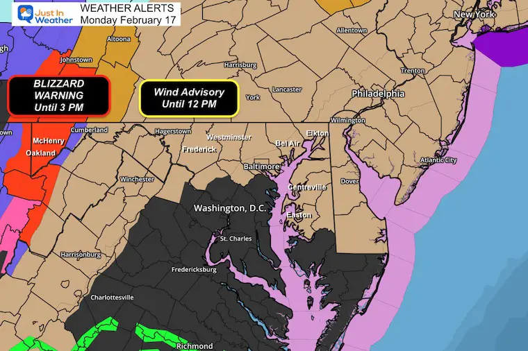
Happy Presidents Day and perhaps you have a day off to clean up up or recoup from the recent weather. We are still feeling the effects of the weekend storm. Due to the Strong Winds, A Wind Advisory has been extended until noon today in roughly half of our area. The Blizzard Warning continues or Western Maryland.
Sunday was wild and lived up to expectations:
BWI in Baltimore:
- 61F High Temperature
- 59 mph Peak Wind Gust
- 0.65” Daily Rainfall = the second wettest day so far this year. The Jan 6 snowstorm was first.
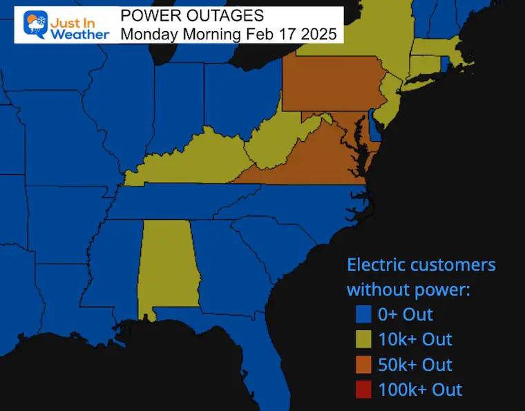
Power Outages Mid-Atlantic States
- Pennsylvania 66,347
- Maryland 53,209
- Virginia 52,486
- New Jersey 31,010
- West Virginia 29,966
- Delaware 2,288
- Washington DC 91
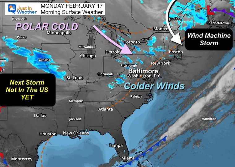
Polar Cold
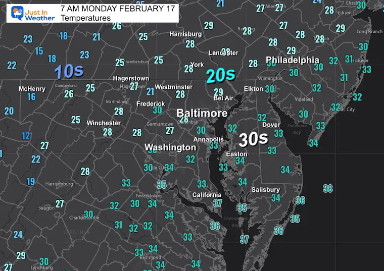
You will surely notice the chill this morning, and the winds remain brisk and gusty. Colder air will continue to filter into the Eastern US over the next few days.
Winter Storm?
It is Presidents Week, and historically, half of our top 25 snowstorms fall this time of year. So when the computer guidance pointed us to a major storm, it was easy to believe.
That winter storm has had a trend on many models farther south to even miss much of Maryland and PA… My hesitation is that the full energy from the Pacific Ocean is not ingested into the modeling yet. It will today. So if there are any more blips in the projected development and track, they will show up today.
I need to emphasize and consider that weather events that did miss this winter have had one thing in common: They verified farther north than models forecasted. Yes, the prime events did hit south of Baltimore, but the misses were plots too far south. There is a bias to push cold air in too soon AND to push it too far south.
Here is what is weird AND NOT wish-casting…. The Euro and Canadian have it missing south, while the American Models GFS and NAM 12K keep it closer.
The current Euro looks similar to what the GFS did last week. So, is it leading the charge with something now? I also need to point out that a few weeks ago, the Euro had been too far south, and the GFS beat it. I made sure to acknowledge this in my storm report, so all bets are not off.
The model run this morning should include the needed energy. By mid-day, I will personally have a better idea if this will be a hit or miss and make my first call.
WEATHER WARNINGS
Blizzard Warning Expires At 3 PM
Garrett County, MD, Also Canaan Valley and Snowshoe, WV
Wind Advisory Expires At Noon
Northern Maryland, Delmarva, and Southern Pennsylvania
CLIMATE DATA: Baltimore
TODAY February 17
Sunrise at 6:55 AM
Sunset at 5:46 PM
Normal Low in Baltimore: 27ºF
Record 3ºF in 1958
Normal High in Baltimore: 47ºF
Record 76ºF 1976
Baltimore Seasonal Snow
12.7”
DROUGHT UPDATE
Rainfall Deficit at BWI
- Ending 2024 = -8.00”
- Since Jan 1 = -0.81”
- We are DOWN -8.81”, including last year!
Morning Temperatures
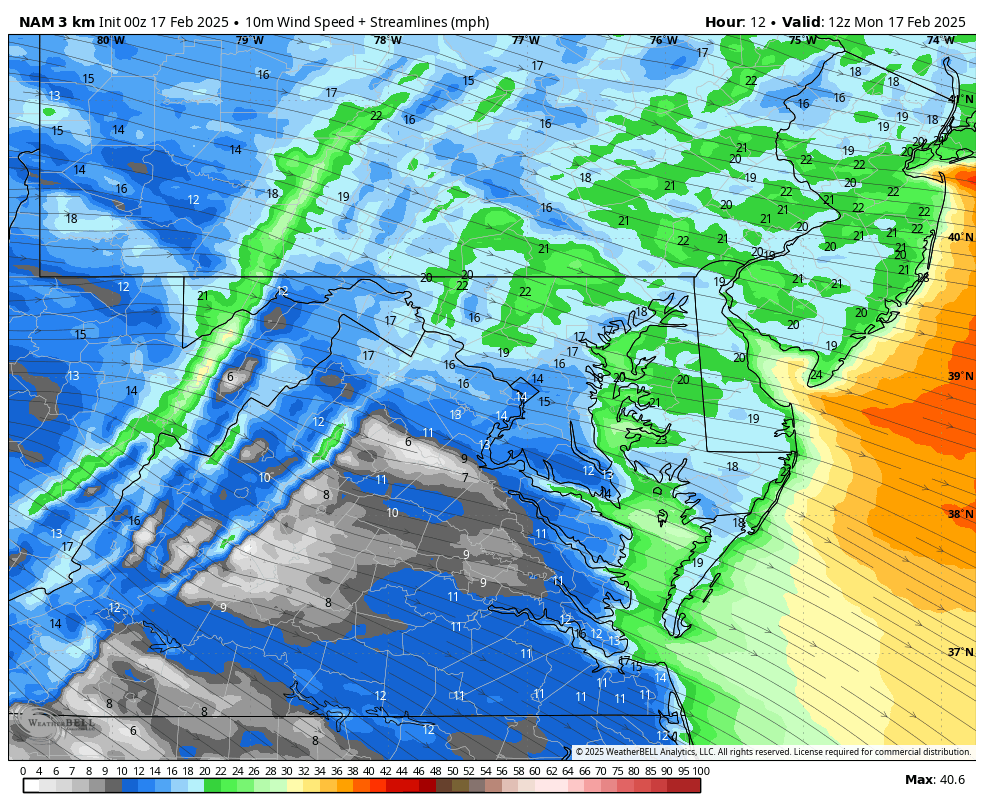
Morning Surface Weather
The storm that is our Wind Machine is racing away and passing Northern Maine. The winds will ease but remain brisk as the edge of the Polar Air continues to spread into the US.
Fun Fact: The Winter Storm we are anticipating is not fully in the US yet…
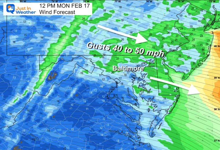
Wind Forecast 7 AM to 7 PM
Winds will peak around mid-day, then ease as we head towards evening.
Snapshot At Noon
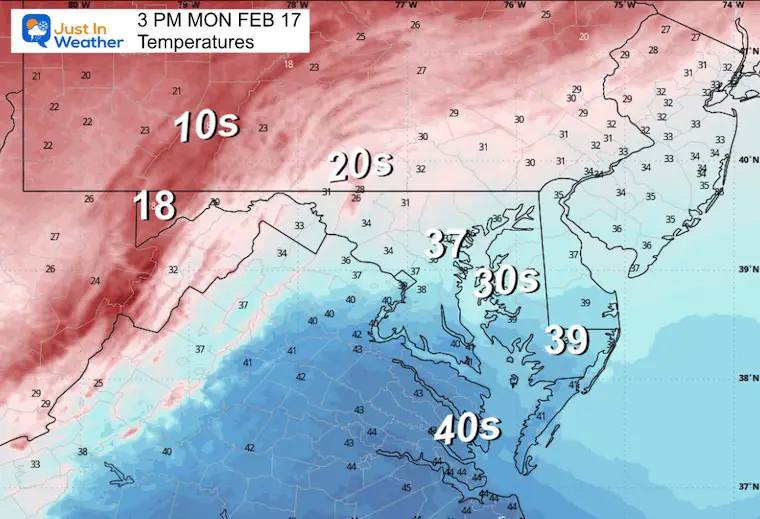
Afternoon Temperatures
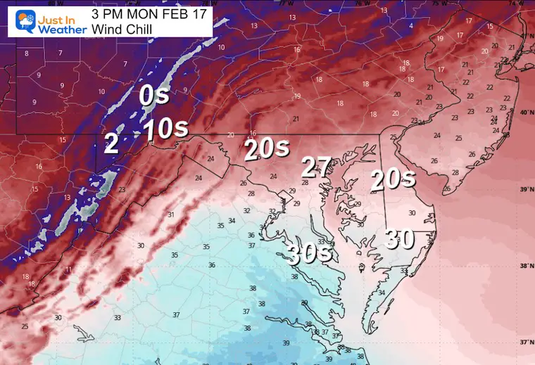
Afternoon Wind Chills
TUESDAY WEATHER
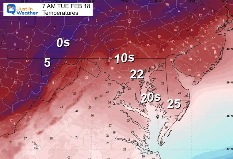
Morning Temperatures
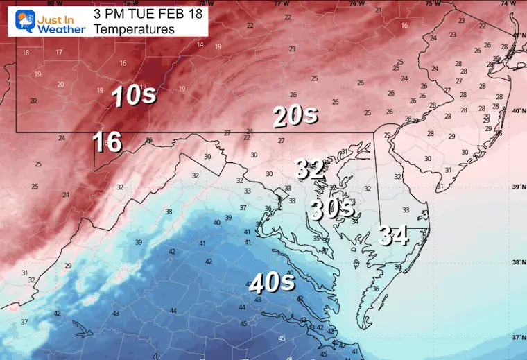
Afternoon Temperatures
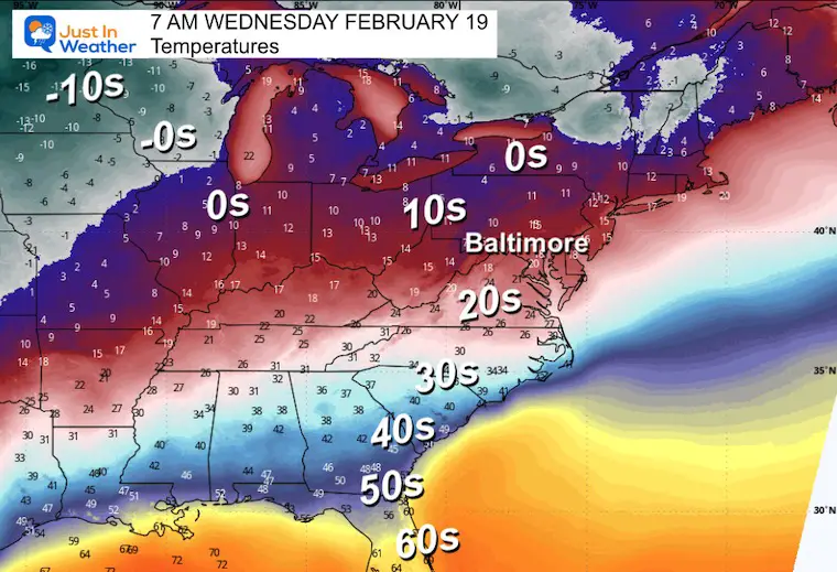
Wednesday Morning Temperatures
(Major) Winter Storm Tracking
Repeating my thoughts:
The major winter storm has had a trend on many models farther south to even miss much of Maryland and PA… My hesitation is that the full energy from the Pacific Ocean is not ingested into the modeling yet. That will happen today.
The weather events that did miss this winter have had one thing in common… they verified farther north than models forecasted. There is a bias to push cold air in too soon AND to push it too far south.
Here is what is weird AND NOT wish-casting…. The Euro and Canadian have it missing south, while the American Models GFS and NAM 12K keep it closer.
The current Euro looks similar to what the GFS did last week. So, is it leading the charge with something now? I also need to point out that a few weeks ago, the Euro had been too far south, and the GFS beat it. I made sure to acknowledge this in my storm report, so all bets are not off.
The model run this morning should include the needed energy. By mid-day, I will personally have a better idea if this will be a hit or miss and make my first call.
Forecast Simulations: Wednesday Morning to Friday Morning
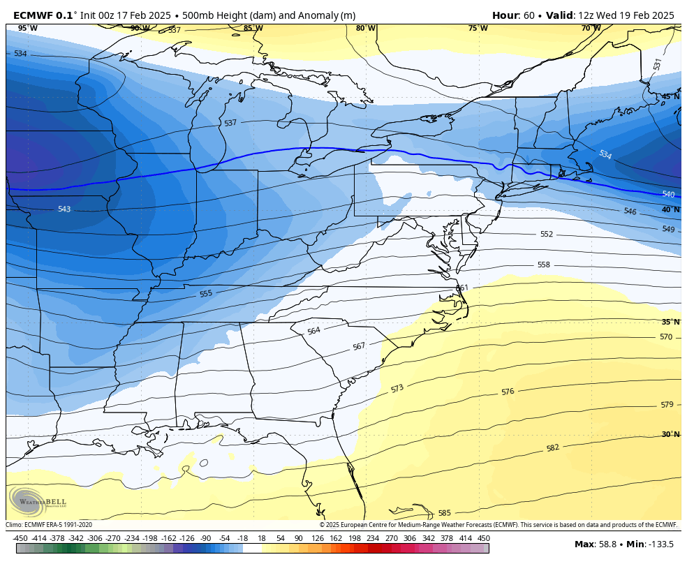
Jet Stream
This will be a strong and cold Upper Level Low. This projection shows it passing through the Mid-Atlantic.
Surface Weather
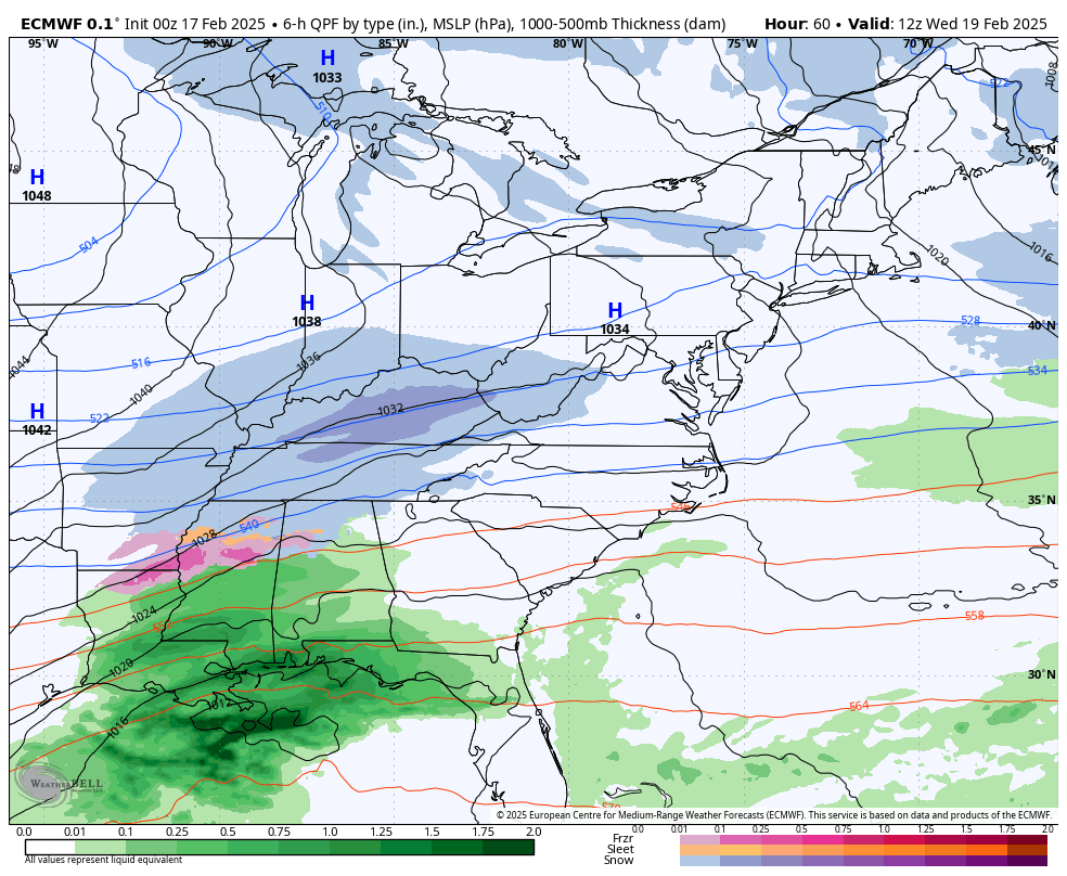
The energy, as seen by the ECMWF Model, does not line up as we thought. The result is NOT a major Nor’easter… This shows a strong storm passing through Virginia and North Carolina and then blowing up off the coast.
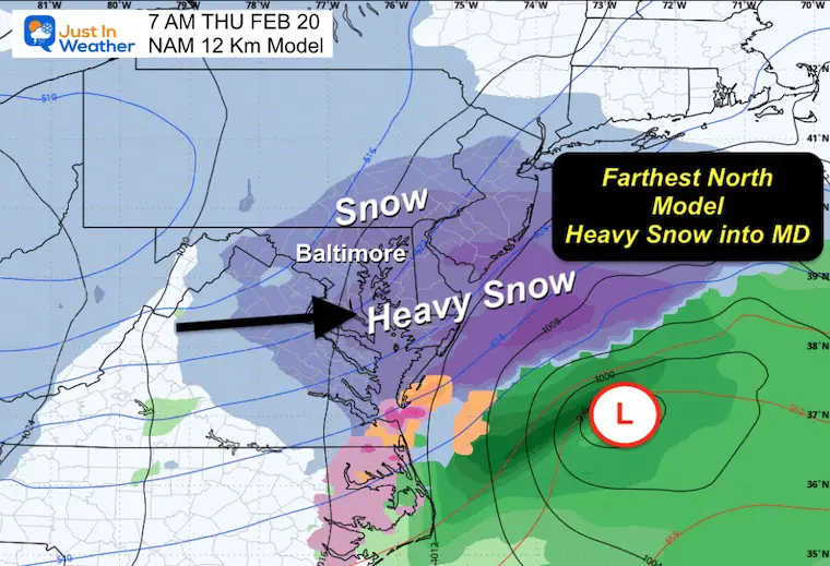
COMPARING MODELS: Thursday Morning
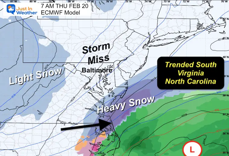
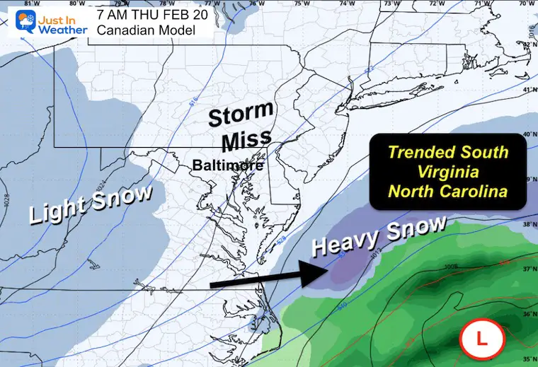
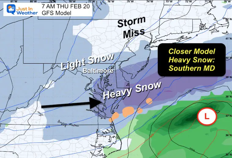
I am using the full model run from 00Z last night. Here are 4 plots for Thursday morning and we can see that the ECMWF and Canadian look like a miss.
Ironically, this is similar to how the GFS looked last week. Now…
The GFS and NAM 12 Km have it farther north with still an impact into Central Maryland.
The Models That Miss Us and Track South
ECMWF Model
Canadian
The Models That Bring The Storm Closer North:
Impact Into Central Maryland
GFS
NAM 12 Km
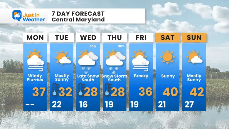
7 Day Forecast
- Polar Air Arriving
- Wednesday to Thursday: Still Monitoring The Possible Major Winter Storm
- Friday: Windy And Staying Cold
Subscribe for eMail Alerts
Subscribe for eMail Alerts
SNOW REPORTS THIS SEASON
Click on the maps for that full report.
February 11 Snow Report And Grade My Forecast
click here or the map for more

January 19 Snow Report

January 11 Snow Report

January 6 Snow Report

Previous Snow

ALSO SEE
Recent Snow Reports
La Nina Advisory January 2025
Full Report

MY WINTER OUTLOOK
My Winter Outlook Report

FITF Gear on Sale

In Case You Missed This
The Faith In The Flakes Dec 5 Origin Story

Please share your thoughts and best weather pics/videos, or just keep in touch via social media.
SCHEDULE A WEATHER BASED STEM ASSEMBLY
Severe Weather: Storm Smart October and next spring Winter Weather FITF (Faith in the Flakes): November To March Click to see more and send a request for your school.

THANK YOU:
Baltimore Magazine Readers Choice Best Of Baltimore
Maryland Trek 11 Day 7 Completed Sat August 10
We raised OVER $104,000 for Just In Power Kids – AND Still Collecting More
The annual event: Hiking and biking 329 miles in 7 days between The Summit of Wisp to Ocean City.
Each day, we honor a kid and their family’s cancer journey.
Fundraising is for Just In Power Kids: Funding Free Holistic Programs. I never have and never will take a penny. It is all for our nonprofit to operate.
Click here or the image to donate:

RESTATING MY MESSAGE ABOUT DYSLEXIA
I am aware there are some spelling and grammar typos and occasional other glitches. I take responsibility for my mistakes and even the computer glitches I may miss. I have made a few public statements over the years, but if you are new here, you may have missed it: I have dyslexia and found out during my second year at Cornell University. It didn’t stop me from getting my meteorology degree and being the first to get the AMS CBM in the Baltimore/Washington region. One of my professors told me that I had made it that far without knowing and to not let it be a crutch going forward. That was Mark Wysocki, and he was absolutely correct! I do miss my mistakes in my own proofreading. The autocorrect spell check on my computer sometimes does an injustice to make it worse. I also can make mistakes in forecasting. No one is perfect at predicting the future. All of the maps and information are accurate. The ‘wordy’ stuff can get sticky. There has been no editor who can check my work while writing and to have it ready to send out in a newsworthy timeline. Barbara Werner is a member of the web team that helps me maintain this site. She has taken it upon herself to edit typos when she is available. That could be AFTER you read this. I accept this and perhaps proves what you read is really from me… It’s part of my charm. #FITF


