February 16 2025
Sunday Morning Report
This current storm still has more to give. The burst of snow and sleet yesterday overachieved and was able to cover the warmer ground mid-day, which led to many accidents. This was actually forecast better on the modeling the day before on the NAM, and all models pulled back just before. I’ve noted this going forward.
Today will be a stormy day. Last night, I discussed the Low-Level Jet with winds over 100mph and 10,000 feet above the ground. This jet will fuel a line of heavy rain that will produce thunderstorms between 11 AM and 4 PM.
Strong winds will actually increase AFTER the storm passes but may help one last cluster of showers late afternoon.
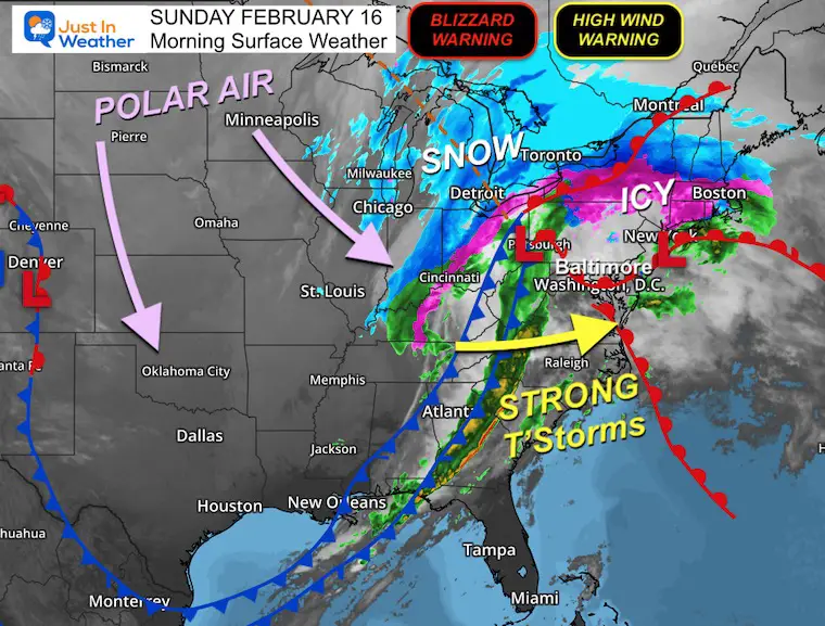
Polar Air begins to arrive and will result in:
- High Winds For All Of Our Region
- Blizzard Conditions In The High Mountains (snow forecast maps below)
- Much Colder Air By Monday and Tuesday
- Winter Storm Wednesday to Thursday
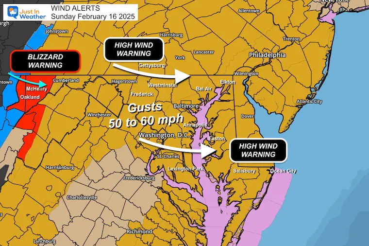
WEATHER WARNINGS From The National Weather Service
Blizzard Warning 1 PM Sun to 3 PM Mon
- Garrett County, MD, Also Canaan Valley and Snowshoe, WV
- Winds to 65 mph AND Heavy Snow!
High Wind Warning 10 AM to 10 PM
- Rest Of Our Region
- Winds Gusts 50 to 60 mph
The active pattern continues:
Monday and Tuesday: Return of Polar Air
Wednesday Night to Thursday:
There has been a shift in the storm’s development over the last day. The upper-level energy alignment with the surface energy has translated to a faster and slightly farther south event. This will still become a major storm. The question is whether it will happen closer to us or farther off the coast.
IMPORTANT: The full energy is NOT ON THE GRID yet. That will enter US airspace and our weather balloon data tonight and tomorrow morning.
CLIMATE DATA: Baltimore
TODAY February 16
Sunrise at 6:57 AM
Sunset at 5:45 PM
Normal Low in Baltimore: 27ºF
Record 5ºF in 1905; 2015
Normal High in Baltimore: 47ºF
Record 75ºF 1954
Baltimore Seasonal Snow
12.7”
DROUGHT UPDATE
Rainfall Deficit at BWI
Ending 2024 = -8.00″, since Jan 1 = -1.35
So we are down -9.35″, including last year!
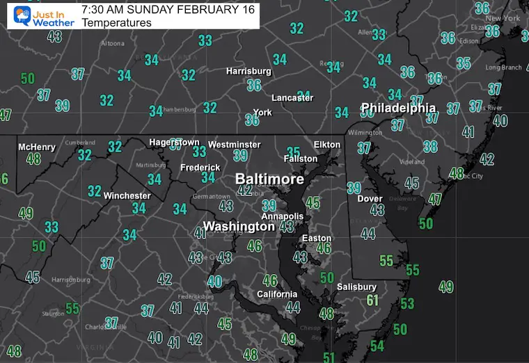
Morning Temperatures
Morning Surface Weather
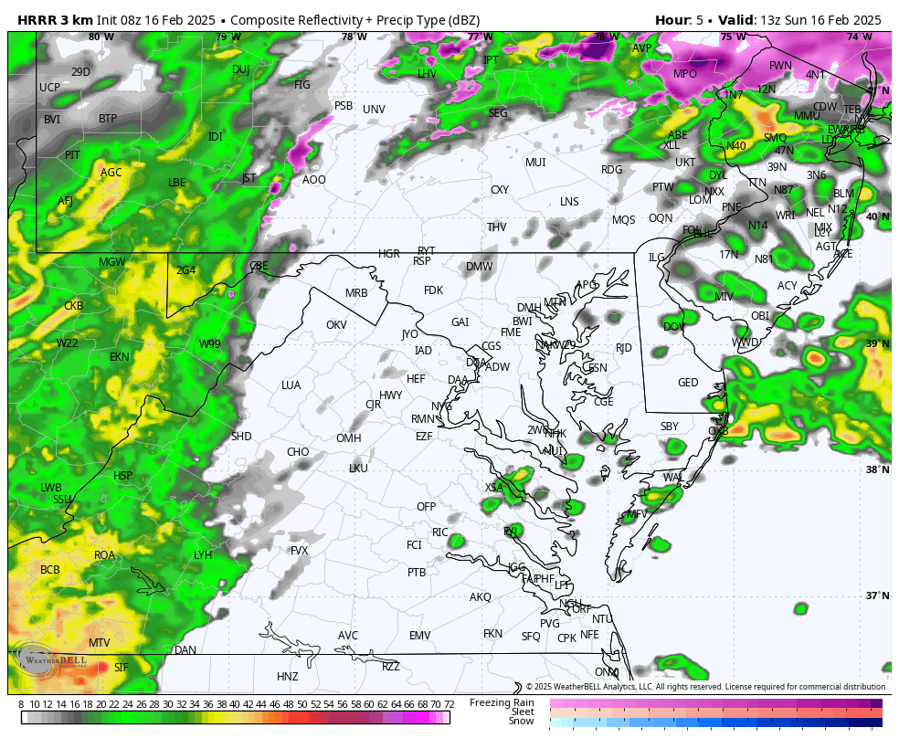
NAM 3Km Model 8 AM to 8 PM
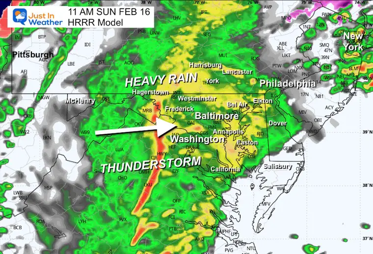
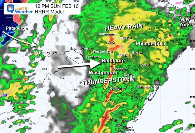
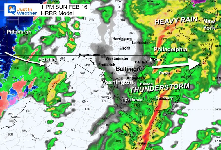
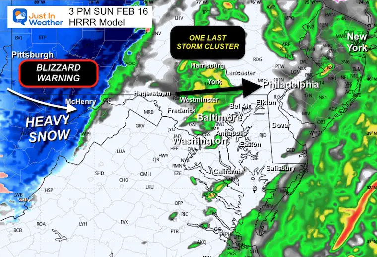
The heavier rain will develop later this morning through early afternoon. Between 11 AM and 2 PM, a line of thunderstorms may develop across Central and Southern Maryland.
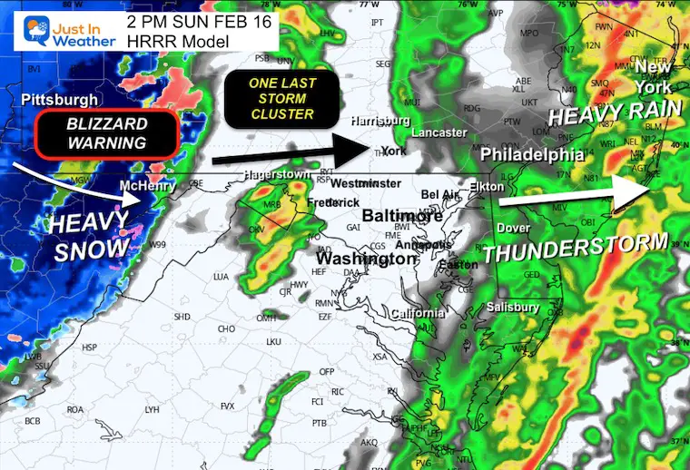
Then, one more cluster of heavy rain late afternoon AND snow develops in the high mountains where a Blizzard Warning kicks in for Garrett County, MD. This also includes ski areas of Canaan Valley and Snowshoe, WV.
Snapshots
11 AM
Metro Baltimore can expect this line any time between 11 Am and 1 PM. Heavier rain and a better chance for thunder will be south.
Noon
Metro Baltimore can expect this line any time between 11 Am and 1 PM. Heavier rain and a better chance for thunder will be south.
1 PM
Metro Baltimore can expect this line any time between 11 Am and 1 PM. Heavier rain and a better chance for thunder will be south.
2 PM
3 PM
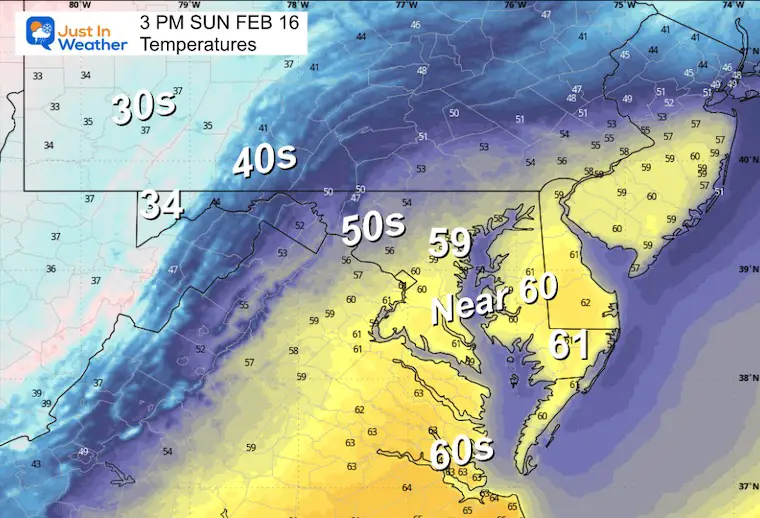
Temperatures
A brief surge of temps close to 60F just before the rush of strong winds and colder air.
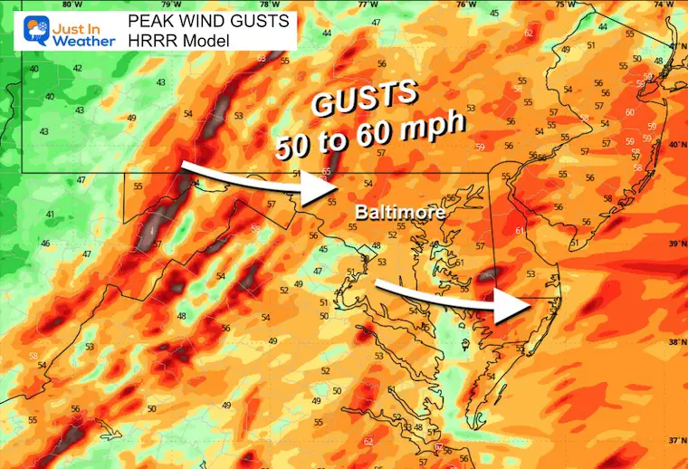
Wind Gusts
These may peak between 2 PM and 8 PM.
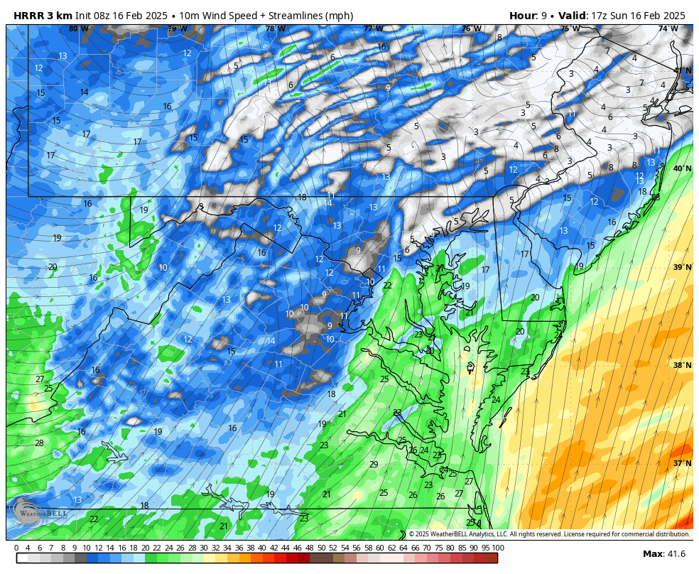
Wind Forecast: Noon to 8 PM
Mountain Snow: Blizzard Warning Area
A blizzard warning is for the winds to exceed 35 mph with the heavy snow.
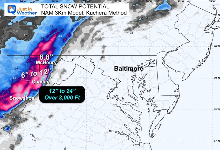
Snow Total Forecasts
NAM 3Km Model
The Kuchera Technique was used to account for temps in the teens and a higher snow ratio.
McHenry = 8.8”
The higher elevations closer to 4,000 Ft may get close to 2 Ft of snow.
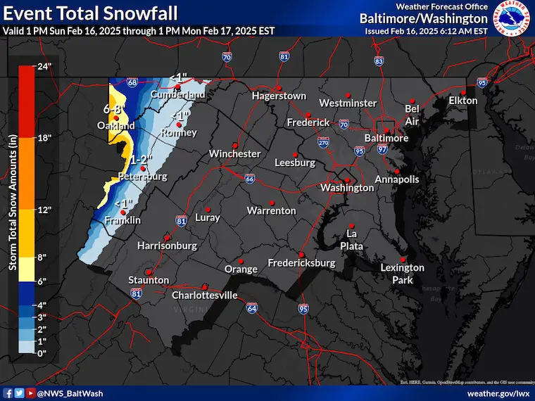
National Weather Service Forecast
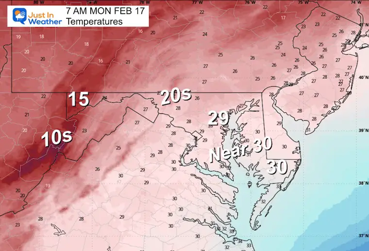
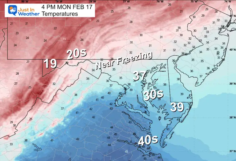
MONDAY WEATHER
Morning Temperatures
Afternoon Temperatures
Polar Air Early Next Week
The influence of the Polar Vortex will send deep arctic air into the US, Well Below Zero across the Northern Plains.
The arrival into our region may be a little later… This may play a role in the next storm next week.
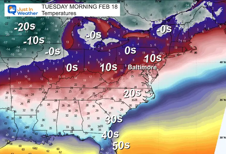
Tuesday Morning
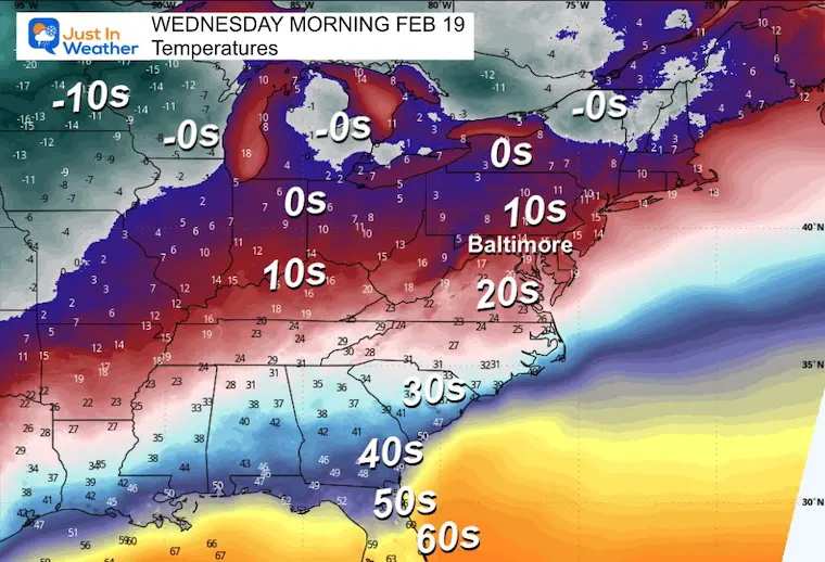
Wednesday Morning
Major Winter Storm
Forecast Simulation: Wednesday Morning to Friday Morning
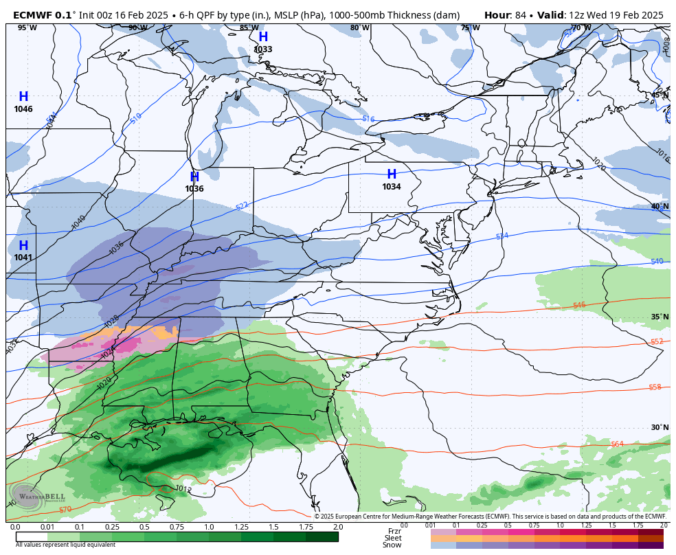
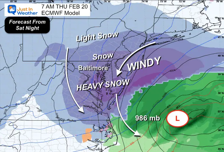
There was a shift in the storm development over the last day. The upper-level energy alignment with the surface energy has translated to a faster and slightly farther south event. This will still become a major storm. The question is if it will happen closer to us or farther off the coast.
I will repeat: The full energy is NOT ON THE GRID yet. That will enter US airspace and our weather balloon data tonight and tomorrow morning.
Snapshots
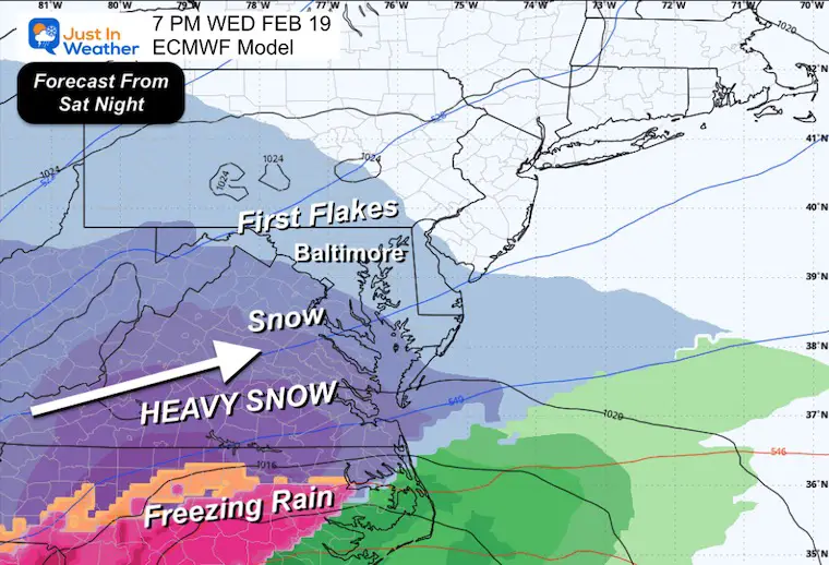
Wednesday Night
Snow will arrive from the South, and light snow may break out into Central Maryland to begin the storm. This is similar to prior model runs.
Thursday Morning
Low Pressure moves off the North Carolina coast and a lock of cold and snow across much of Maryland.
This has shifted a little farther south and east from the plots in the last two days.
(The specifics are STILL subject to some change).
COMPARING MODELS
Canadian and American GFS Models have also shifted the snow even farther south. I do not buy into abrupt changes until I see consecutive model runs consistently showing them. I expect there will be more fluctuation until the full data is available on Monday morning.
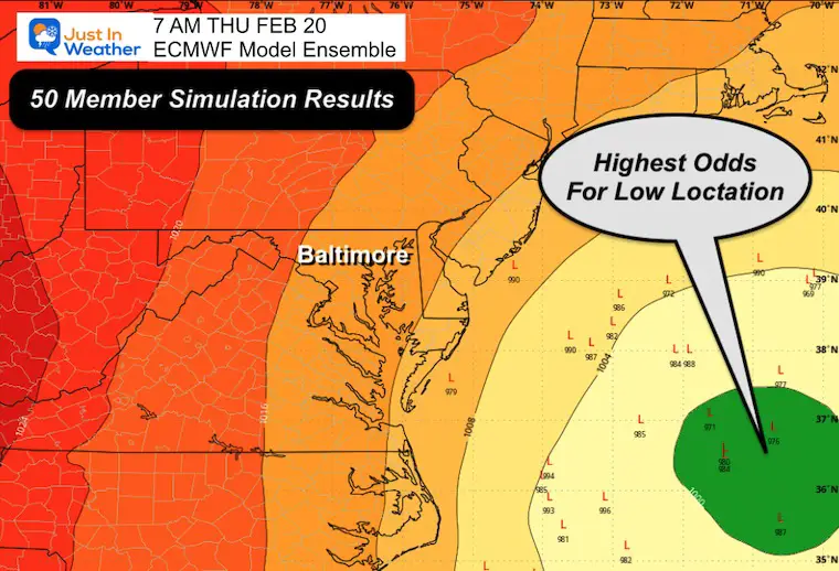
Ensemble Low Location
Based on the 50-member Ensemble of the European Model:
Here are the greatest odds of where the storm will be tracking. There is still a wide range of possibilities.
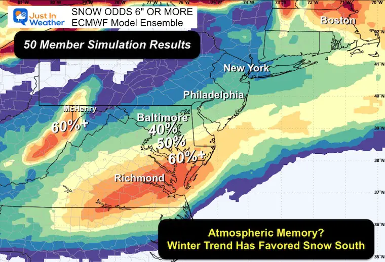
Snow Potential
Based on the 50-member Ensemble of the European Model:
Here are the odds of getting 6 inches of snow or more.
This has shifted south, AND I expected more fluctuation until full data is available Monday morning.
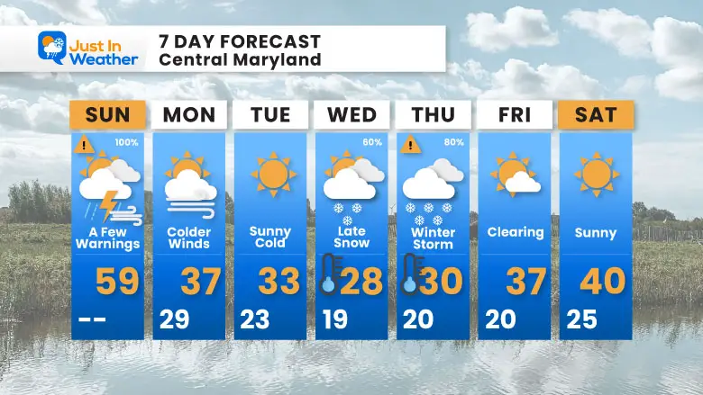
7 Day Forecast
- Sunday: T’Storms, Warm, then Strong Winds
- Monday to Wednesday Polar Cold Arrives
- Wednesday to Thursday: Still Monitoring The Possible Major Winter Storm
- Friday: Windy And Staying Cold For The Cleanup
Subscribe for eMail Alerts
SNOW REPORTS THIS SEASON
Click on the maps for that full report.
February 11 Snow Report And Grade My Forecast
click here or the map for more

January 19 Snow Report

January 11 Snow Report

January 6 Snow Report

Previous Snow

ALSO SEE
Recent Snow Reports
La Nina Advisory January 2025
Full Report

MY WINTER OUTLOOK
My Winter Outlook Report

FITF Gear on Sale

In Case You Missed This
The Faith In The Flakes Dec 5 Origin Story

Please share your thoughts and best weather pics/videos, or just keep in touch via social media.
SCHEDULE A WEATHER BASED STEM ASSEMBLY
Severe Weather: Storm Smart October and next spring Winter Weather FITF (Faith in the Flakes): November To March Click to see more and send a request for your school.

THANK YOU:
Baltimore Magazine Readers Choice Best Of Baltimore
Maryland Trek 11 Day 7 Completed Sat August 10
We raised OVER $104,000 for Just In Power Kids – AND Still Collecting More
The annual event: Hiking and biking 329 miles in 7 days between The Summit of Wisp to Ocean City.
Each day, we honor a kid and their family’s cancer journey.
Fundraising is for Just In Power Kids: Funding Free Holistic Programs. I never have and never will take a penny. It is all for our nonprofit to operate.
Click here or the image to donate:

RESTATING MY MESSAGE ABOUT DYSLEXIA
I am aware there are some spelling and grammar typos and occasional other glitches. I take responsibility for my mistakes and even the computer glitches I may miss. I have made a few public statements over the years, but if you are new here, you may have missed it: I have dyslexia and found out during my second year at Cornell University. It didn’t stop me from getting my meteorology degree and being the first to get the AMS CBM in the Baltimore/Washington region. One of my professors told me that I had made it that far without knowing and to not let it be a crutch going forward. That was Mark Wysocki, and he was absolutely correct! I do miss my mistakes in my own proofreading. The autocorrect spell check on my computer sometimes does an injustice to make it worse. I also can make mistakes in forecasting. No one is perfect at predicting the future. All of the maps and information are accurate. The ‘wordy’ stuff can get sticky. There has been no editor who can check my work while writing and to have it ready to send out in a newsworthy timeline. Barbara Werner is a member of the web team that helps me maintain this site. She has taken it upon herself to edit typos when she is available. That could be AFTER you read this. I accept this and perhaps proves what you read is really from me… It’s part of my charm. #FITF


