


My Call For Snowfall Saturday Morning Inland And Sunday Closer To The Coast
Friday Evening Update January 16 2026 Two weather events will bring snow to our region this weekend. They are related to the fast winds aloft on the edge of this…
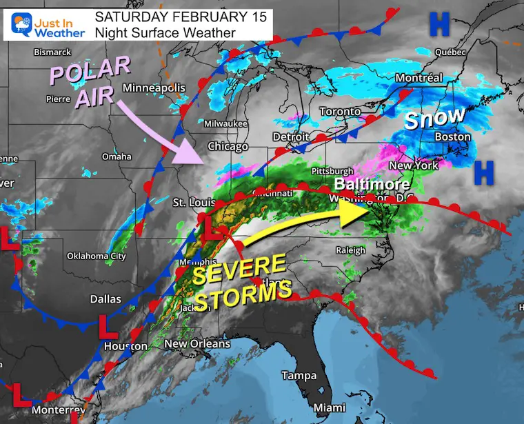
Saturday Night February 15
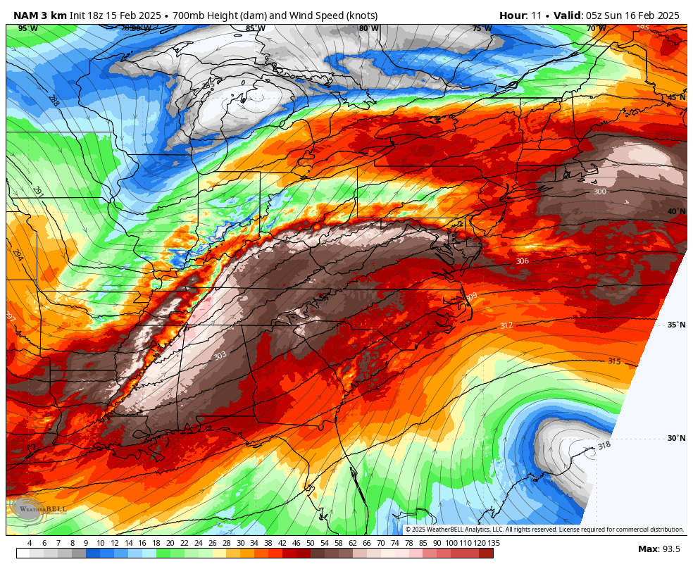
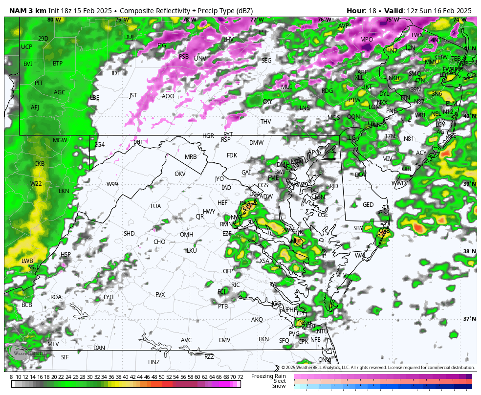
The snow and sleet that arrived today did burst more than expected. I had called it an overachiever because the intensity pulsed enough to overtake the warm pavement and lead to road stickage and lots of accidents. In retrospect, I had shown the snow and sleet in prior days, and the NAM 3 Km Model actually did a better job yesterday than this morning.
I mention that because I will be showing that model primarily for the next phase of this storm on Sunday.
I understand there may be more interest in the larger snow storm next week, but I do not want to ignore the impact of this immediate event.
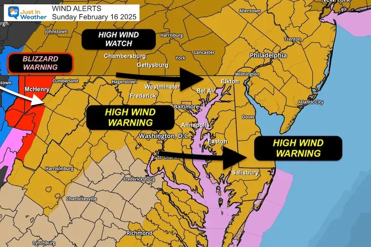
High Mountains, including Garrett County, MD.
This strong storm has been responsible for severe storms and flooding across the Tennessee River Valley.
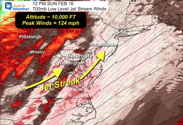
700mb: 10,000 Ft Altitude
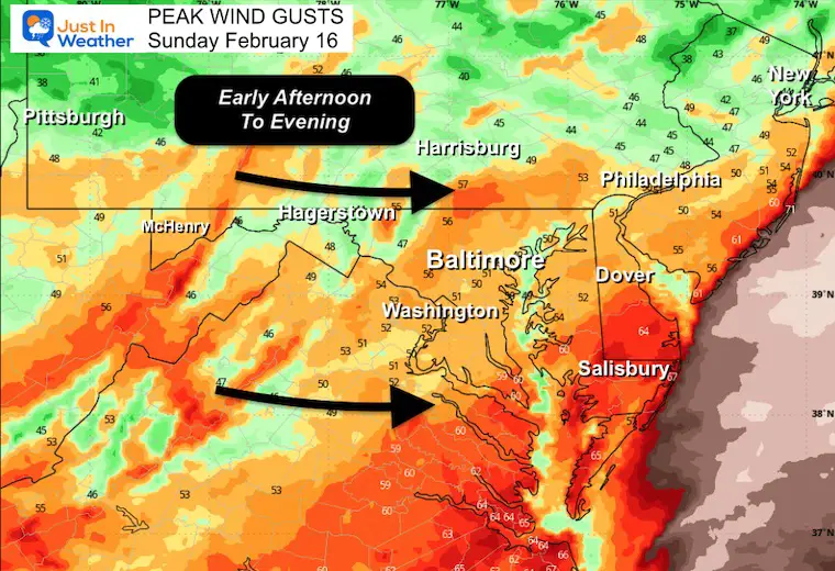
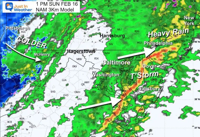
The forecast low-level jet will peak over 100 mph over Central Maryland around noon Sunday.
This low-level jet will cross Virginia and Maryland at a potential speed of 124 mph. This will enhance the line of thunderstorms and open up the winds to come closer to the surface as the cold air follows.
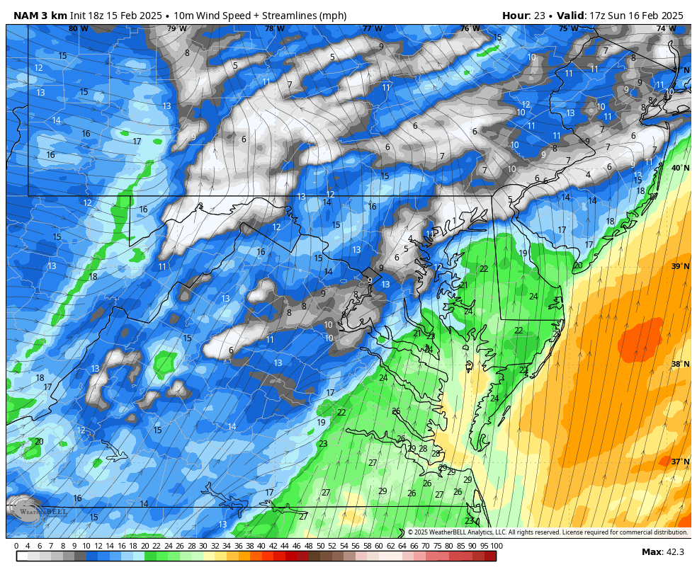
Showers may end in the morning, and a surge of warm air will feed the developing line of heavy rain and thunderstorms late morning and early afternoon.
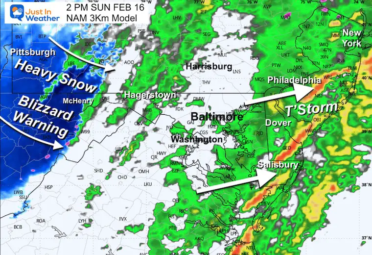
The cold winds that follow will ignite a Lake Effect Snow Event with the winds for the mountains of Western Maryland.
The line of showers and thunderstorms will be developing.
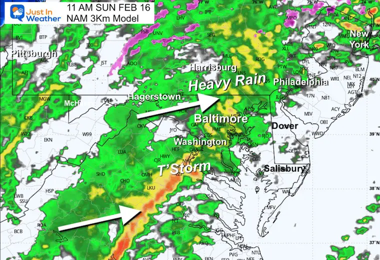
A strong line of heavy rain with thunderstorms, more likely south of Baltimore.
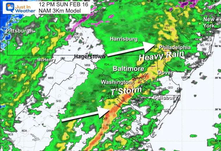
Storm line will cross the Bay to Delmarva.
As the line of storms reaches the coast, the snow will begin to take hold in the mountains.
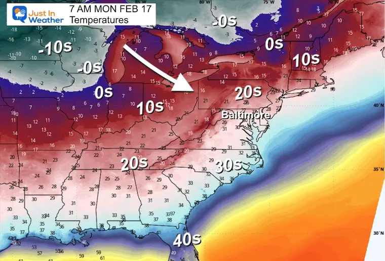
Colder air will flow in and expand eastward overnight and into Monday morning.
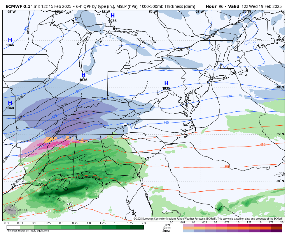
This is the ECMWF Model run Saturday morning.
There has been a shift with the computer models, and with 5 days to go, I expect there will be more. I am not worried.
What I have noticed was the energy in the jet stream was a little flatter in the rain earlier today.
This still produces a snowstorm… in fact a stronger Low Pressure. But the comparison was about 150 miles farther east Thursday Morning.
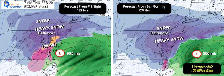
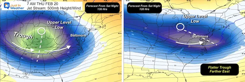
The main reason for this change has been the jet stream. Here at 18,000 ft, the trough in the latest plot was not as deep, so the storm will still be strong but does not have the support to turn up the coast. It’s just the upper-level part of the entire package, and I will be looking for it to see if this is the trend or a blip.
If you have been scanning other pages, you may have seen very high numbers pull back. This is why I DO NOT show snow totals more than three days away. What I did show and reserve for special events is a product with the odds of at least 6 inches of snow. Once we hit 50%, I get more confident about showing that, and I have.
I will still not begin to show a range of snow totals until we have more reliable data. That will not begin to take form until Monday, when the actual energy for this storm enters the grid. That means over US airspace for the weather balloons on the Pacific Northwest to get a better sample of what is trying to head our way.
If you look at models, I must emphasize I ONLY LOOK AT 00Z ( 7PM) and 12Z (7 AM) runs when we are more than 48 hours away from a storm.
The 06Z (1AM) and 18Z (1PM) models do NOT have a complete data set without standard weather balloon data.
That is why there can often be glitches or flips.
The thing I am looking for with the next two runs is if this holds, trends farther east, or comes back to the prior setup.
We are still 5 DAYS AWAY so there is always going to be some wiggle room.
Faith in the Flakes
Sign up and be the first to know!
Click on the maps for that full report.
click here or the map for more


Severe Weather: Storm Smart October and next spring Winter Weather FITF (Faith in the Flakes): November To March Click to see more and send a request for your school.

The annual event: Hiking and biking 329 miles in 7 days between The Summit of Wisp to Ocean City.
Each day, we honor a kid and their family’s cancer journey.
Fundraising is for Just In Power Kids: Funding Free Holistic Programs. I never have and never will take a penny. It is all for our nonprofit to operate.
Click here or the image to donate:

I am aware there are some spelling and grammar typos and occasional other glitches. I take responsibility for my mistakes and even the computer glitches I may miss. I have made a few public statements over the years, but if you are new here, you may have missed it: I have dyslexia and found out during my second year at Cornell University. It didn’t stop me from getting my meteorology degree and being the first to get the AMS CBM in the Baltimore/Washington region. One of my professors told me that I had made it that far without knowing and to not let it be a crutch going forward. That was Mark Wysocki, and he was absolutely correct! I do miss my mistakes in my own proofreading. The autocorrect spell check on my computer sometimes does an injustice to make it worse. I also can make mistakes in forecasting. No one is perfect at predicting the future. All of the maps and information are accurate. The ‘wordy’ stuff can get sticky. There has been no editor who can check my work while writing and to have it ready to send out in a newsworthy timeline. Barbara Werner is a member of the web team that helps me maintain this site. She has taken it upon herself to edit typos when she is available. That could be AFTER you read this. I accept this and perhaps proves what you read is really from me… It’s part of my charm. #FITF