February 15, 2025
Saturday Morning Report
There is so much going on; it may be overwhelming, but I touch on it all here.
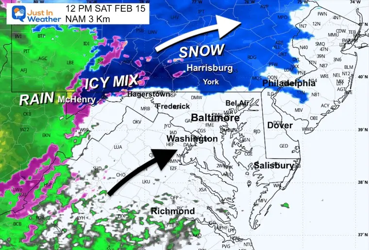
This morning, light snow is trying to build in and may spread to metro areas by noon. Roads are expected to stay wet, and a transition to mix and rain, plus fog, later in the day.
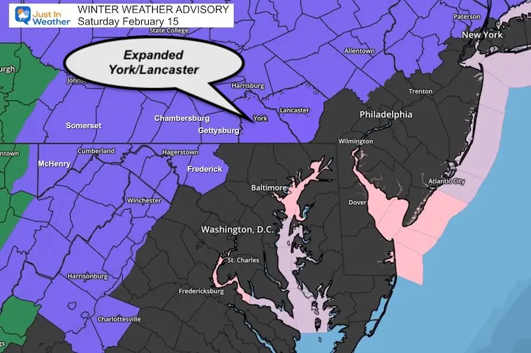
A Winter Weather Advisory includes Maryland from Frederick County westward and parts of Southern Pennsylvania. Any road impact will be in higher elevations and shaded spots.
The mix of snow, sleet, and freezing rain will turn to rain as warmer air arrives Saturday night and Sunday.
Periods of heavy rain and thunderstorms are possible on Sunday.
Weekend Weather Alerts
Winter Weather Advisory
Maryland Mountains west of Frederick and Southern Pennsylvania.
This has been EXPANDED to include York and Lancaster Counties.
High Wind Watch
The strongest Winds will be mid-afternoon to evening, with gusts up to 60 mph.

Quick View Weekend Winter Storm
Saturday Afternoon to Monday Morning
The active pattern continues:
Monday and Tuesday: Return of Polar Air
Wednesday to Thursday: The next winter storm has more support to be a major impact across the Mid-Atlantic and Northeast US. Heavy snow and strong winds will peak on Thursday.
CLIMATE DATA: Baltimore
TODAY February 15
Sunrise at 6:58 AM
Sunset at 5:44 PM
Normal Low in Baltimore: 27ºF
Record 6F in 1899, 1943, 2015
Normal High in Baltimore: 46ºF
Record 77ºF 1949
Baltimore Seasonal Snow
12.7”
DROUGHT UPDATE
Rainfall Deficit at BWI
Ending 2024 = -8.00″, since Jan 1 = -1.67
So we are down -9.67″, including last year!
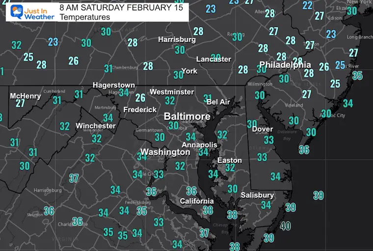
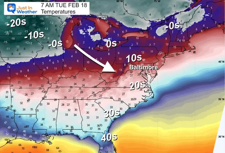
Morning Temperatures
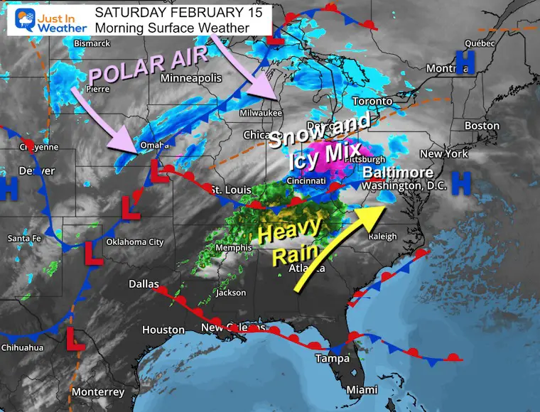
Morning Surface Weather
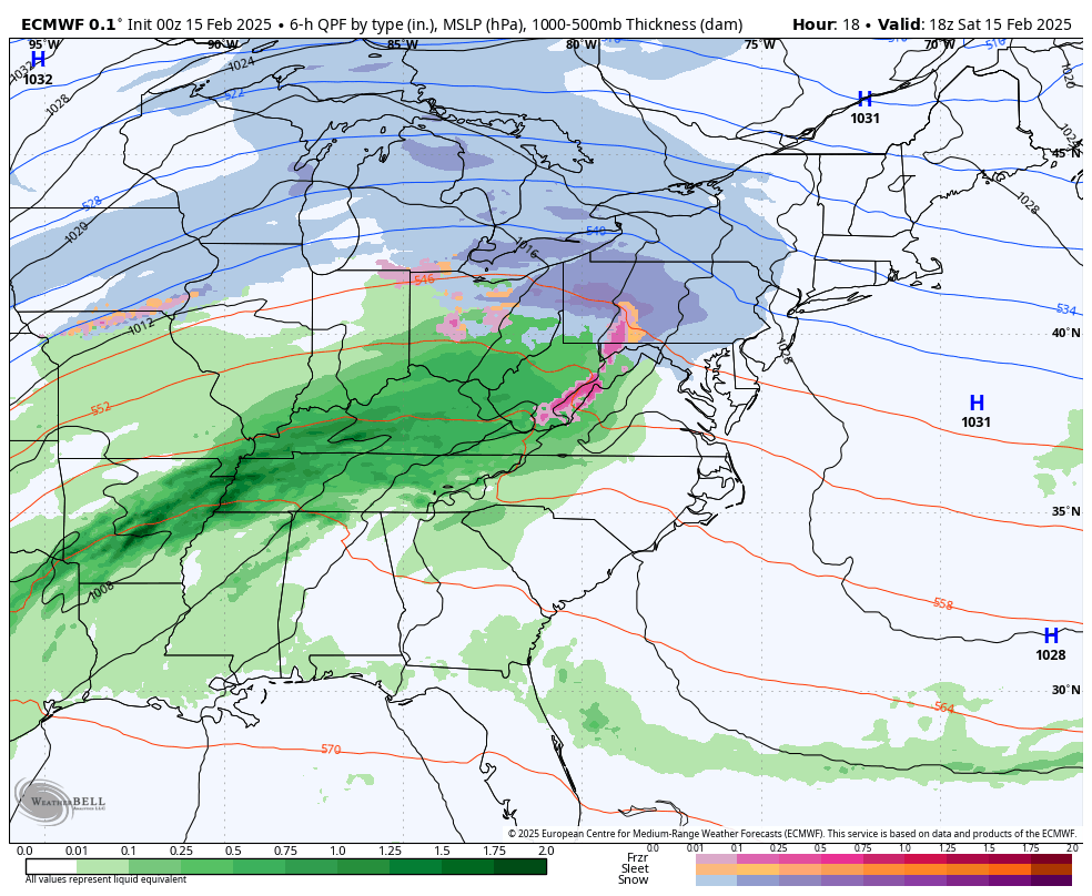
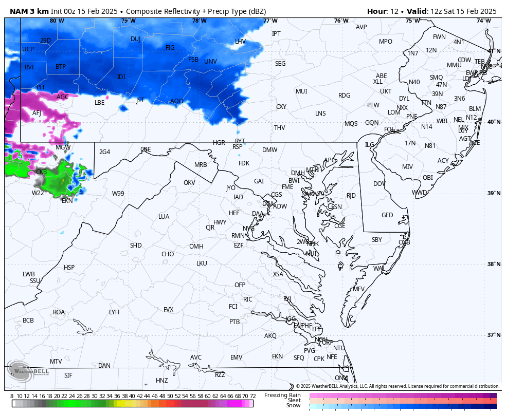
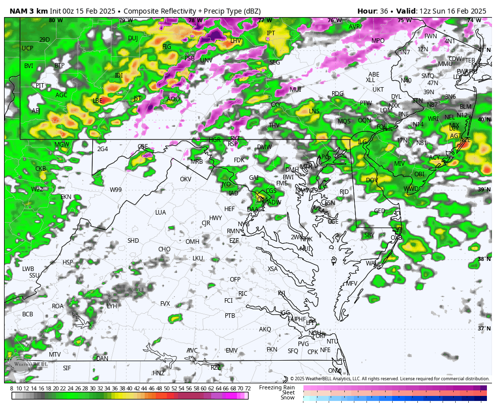
A very complex storm has brought a mix of snow up the Ohio Valley and will be heading our way mid-day.
Warmer air and heavy rain will try to push in from the south.
In the Northern Plains, the leading edge of Polar Air is poised to move in following the storm.
Closer Look
NAM 3Km Model 7 AM to Midnight
Light snow this morning… but metro area roads should stay wet. The impact will be in the Advisory areas, especially in higher elevations and shaded areas.
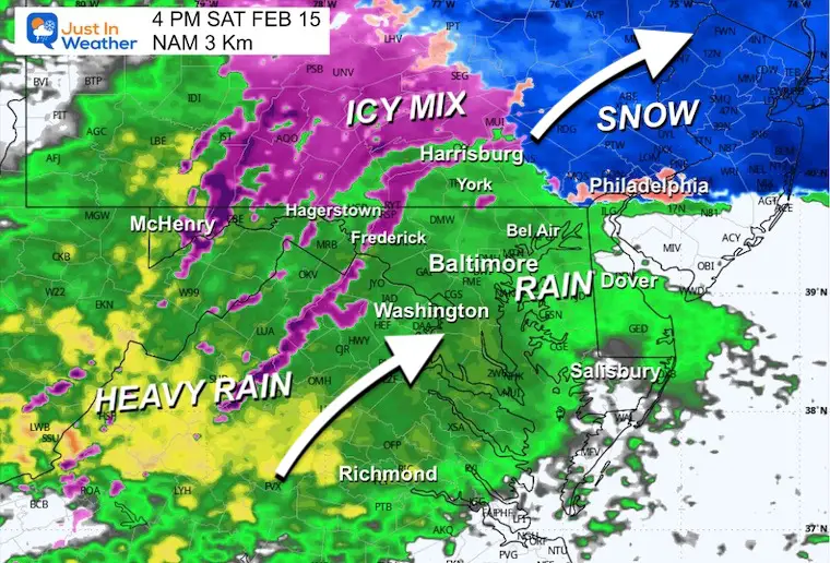
Gradually, a mix over to rain will occur during the day… then in the evening in the Advisory area.
Snapshots
Noon
4 PM
8 PM

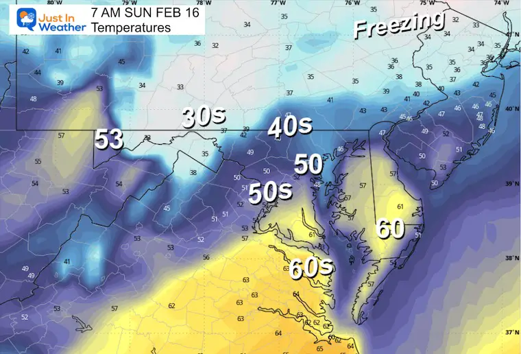
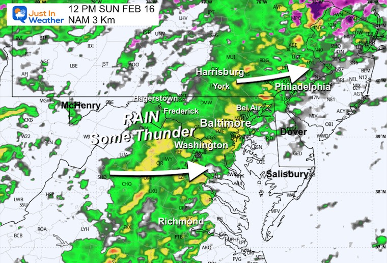
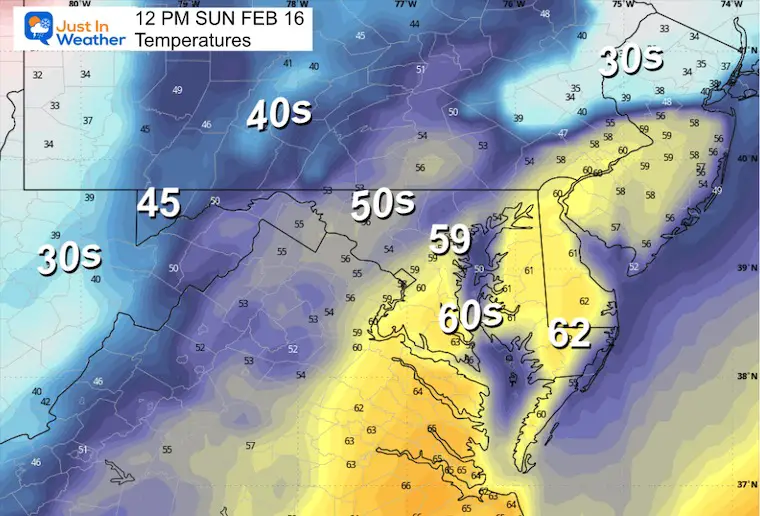
SUNDAY WEATHER
- While the warm side of the storm pushes in, we may get some very thick fog.
- In addition, there will be rain showers and possibly thunder mixed in.
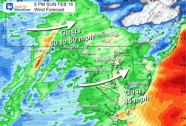
- The cold front arrives in the afternoon and will pump wind gusts up to 60 mph after 4 PM.
- As cold air returns, heavy snow will develop and impact travel in the mountains.
7 AM Radar and Temps
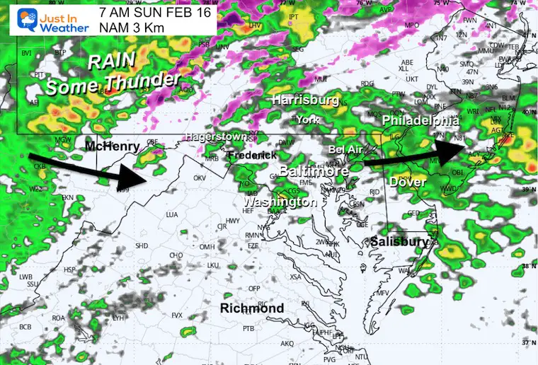
Radar Simulation 7 AM to Midnight
Noon Snapshot
Periods of heavy rain and thunderstorms.
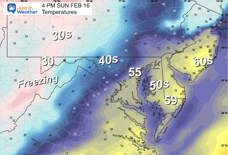
4 PM Radar and Temps
This is when the winds will pick up, AND the heavy snow will develop in the mountains.

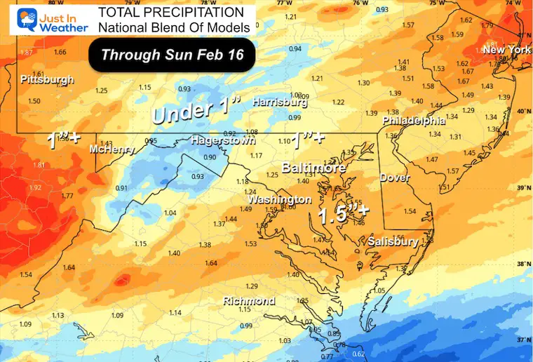
TOTAL PRECIPITATION
Wind Forecast
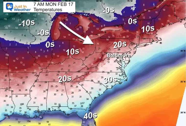
Polar Air Early Next Week
The influence of the Polar Vortex will send deep arctic air into the US, Well Below Zero across the Northern Plains.
The arrival into our region may be a little later… This may play a role in the next storm next week.
Monday Morning
Tuesday Morning
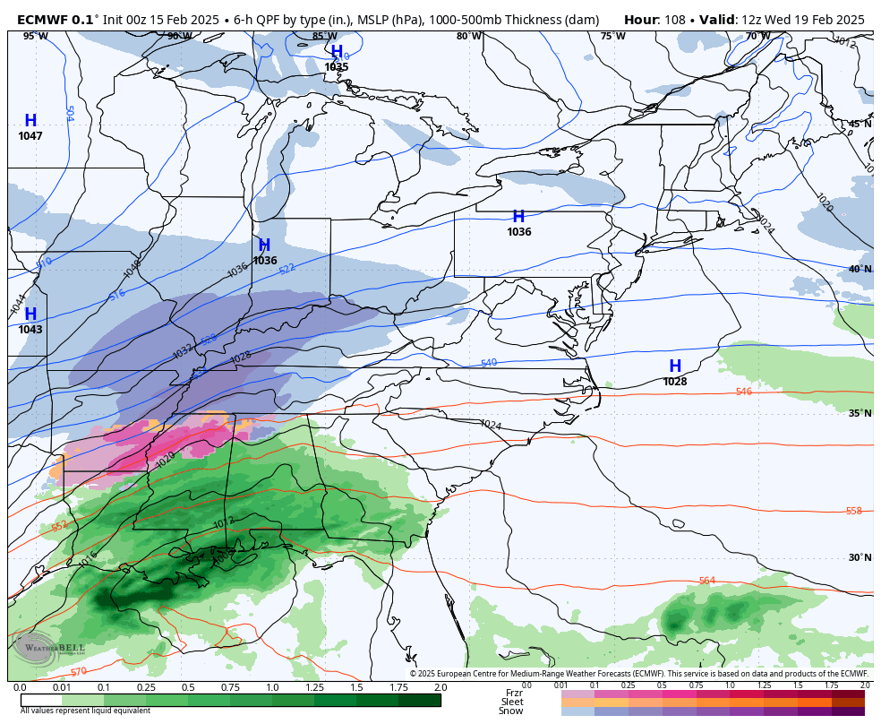
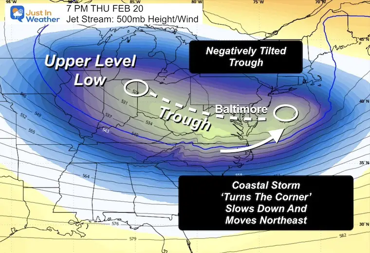
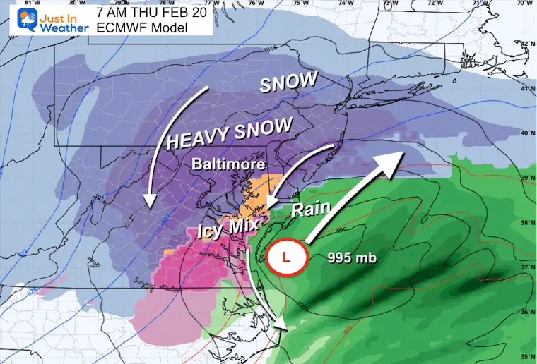
Major Winter Storm
Forecast Simulation: Wednesday Morning to Friday Morning
The setup with polar air in place and the upper-level energy may line up just right to produce a True Nor’easter that peaks on Thursday. Pressure levels will drop fast and blizzard conditions are possible with high winds and heavy snow.
To see a deep dive into how this may form and why it is a big deal, click here for my report.
Snapshots
Snow may begin late Wednesday, and then the focus will be on Thursday!
Thursday Morning
Low Pressure moves off the North Carolina coast and a lock of cold and snow across much of Maryland.
The specifics are subject to some change.
COMPARING MODELS
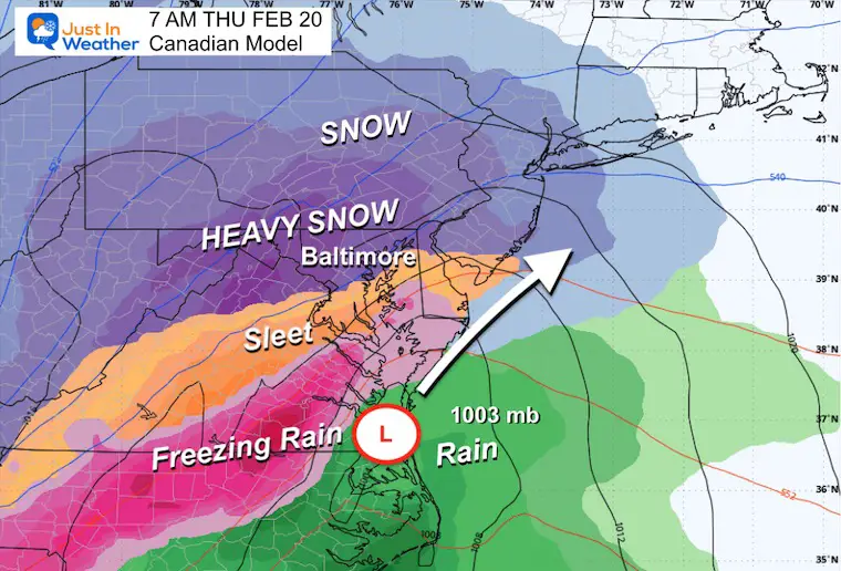
Canadian
The Canadian thrives with polar air and has been similar to the European Model. This is a little farther inland, with the mix line closer to the big cities. Still, it is a negligible factor this far away.
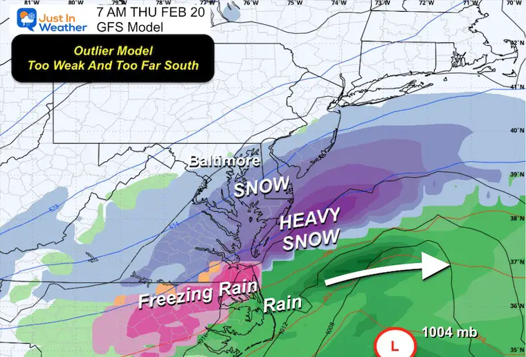
American GFS Model
This model has been the least consistent and bouncing around plots. It has tended to be faster, weaker, and farther south with the storm track.
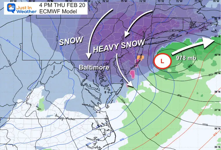
Thursday Afternoon
Storm Track moves east off the coast with a 978 mb Low. That would be equal to a Category 2 Hurricane and may produce blizzard conditions.
Heavy snow will taper to snow showers overnight.
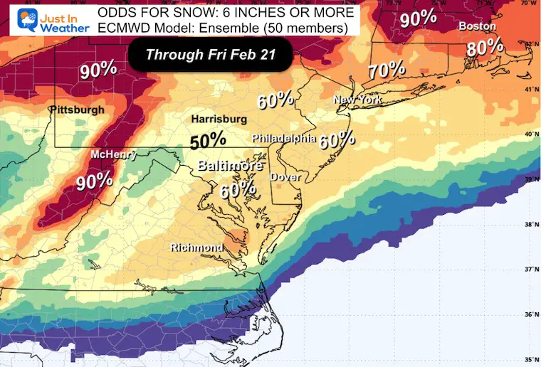
Snow Potential
Based on the 50-member Ensemble of the European Model:
Here are the odds of getting 6 inches of snow or more. This has held firm since yesterday… showing consistency in the model.
7 Day Forecast
- Today: Icy Mix to Rain and Fog
- Sunday: T’Storms, Warm, Then Strong Winds
- Monday to Wednesday: Polar Cold Arrives
- Wednesday to Thursday: Major Winter Storm
- Friday: Windy And Staying Cold For The Cleanup

Subscribe for eMail Alerts
SNOW REPORTS THIS SEASON
Click on the maps for that full report.
February 11 Snow Report And Grade My Forecast
click here or the map for more

January 19 Snow Report

January 11 Snow Report

January 6 Snow Report

Previous Snow

ALSO SEE
Recent Snow Reports
La Nina Advisory January 2025
Full Report

MY WINTER OUTLOOK
My Winter Outlook Report

FITF Gear on Sale

In Case You Missed This
The Faith In The Flakes Dec 5 Origin Story

Please share your thoughts and best weather pics/videos, or just keep in touch via social media.
SCHEDULE A WEATHER BASED STEM ASSEMBLY
Severe Weather: Storm Smart October and next spring Winter Weather FITF (Faith in the Flakes): November To March Click to see more and send a request for your school.

THANK YOU:
Baltimore Magazine Readers Choice Best Of Baltimore
Maryland Trek 11 Day 7 Completed Sat August 10
We raised OVER $104,000 for Just In Power Kids – AND Still Collecting More
The annual event: Hiking and biking 329 miles in 7 days between The Summit of Wisp to Ocean City.
Each day, we honor a kid and their family’s cancer journey.
Fundraising is for Just In Power Kids: Funding Free Holistic Programs. I never have and never will take a penny. It is all for our nonprofit to operate.
Click here or the image to donate:

RESTATING MY MESSAGE ABOUT DYSLEXIA
I am aware there are some spelling and grammar typos and occasional other glitches. I take responsibility for my mistakes and even the computer glitches I may miss. I have made a few public statements over the years, but if you are new here, you may have missed it: I have dyslexia and found out during my second year at Cornell University. It didn’t stop me from getting my meteorology degree and being the first to get the AMS CBM in the Baltimore/Washington region. One of my professors told me that I had made it that far without knowing and to not let it be a crutch going forward. That was Mark Wysocki, and he was absolutely correct! I do miss my mistakes in my own proofreading. The autocorrect spell check on my computer sometimes does an injustice to make it worse. I also can make mistakes in forecasting. No one is perfect at predicting the future. All of the maps and information are accurate. The ‘wordy’ stuff can get sticky. There has been no editor who can check my work while writing and to have it ready to send out in a newsworthy timeline. Barbara Werner is a member of the web team that helps me maintain this site. She has taken it upon herself to edit typos when she is available. That could be AFTER you read this. I accept this and perhaps proves what you read is really from me… It’s part of my charm. #FITF


