February 13 2025
Thursday Morning Report
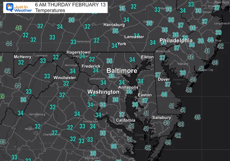
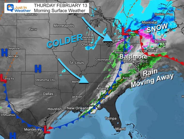
This morning, most of the region is safely above freezing, and the bulk of the rain is moving away. We will have lingering fog and rain showers this morning, then warmer weather this afternoon.
We are still on the edge of cold air, and that will work back tomorrow and may hold to allow for a wintry mix to begin Saturday before turning to another rain event Saturday night and Sunday.
The active pattern continues:
Monday and Tuesday: Return of Polar Air
Wednesday to Thursday: The Next Storm is still debatable, but it is worth watching for more snow and ice. Compare the model plots below.
CLIMATE DATA: Baltimore
TODAY February 13
Sunrise at 7:00 AM
Sunset at 5:42 PM
Normal Low in Baltimore: 26ºF
Record 1F in 1983
Normal High in Baltimore: 46ºF
Record 72ºF 1951
Baltimore Seasonal Snow
12.7” – Very Close To Average
DROUGHT UPDATE
Rainfall Deficit at BWI
Ending 2024 = -8.00″, since Jan 1 = -1.70
So we are down -9.70″, including last year!
February 11 Snow Report And Grade My Forecast
click here or the map for more

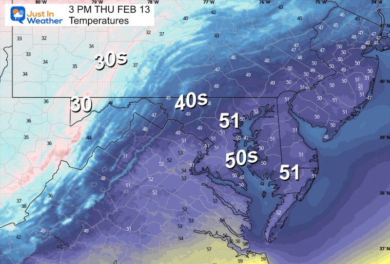
THURSDAY: Morning Temperatures
Morning Surface Weather
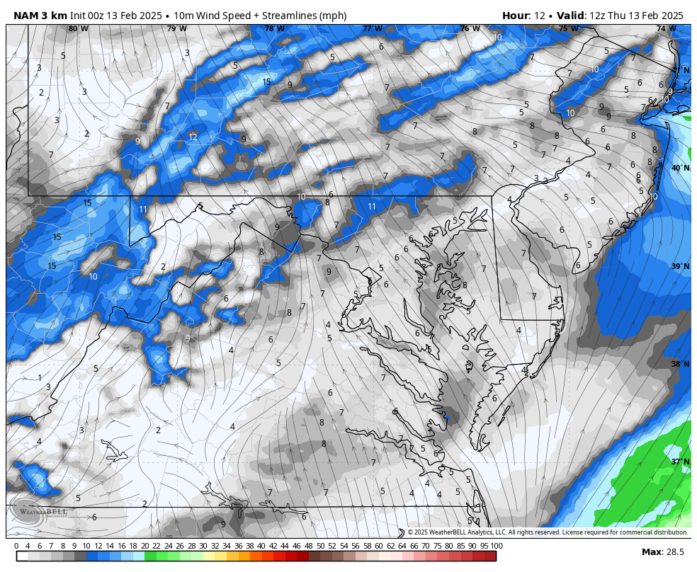
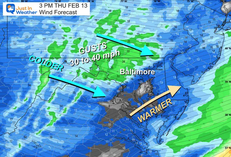
Wind Forecast 7 AM to Midnight
Warm winds will help dry us out, then colder air will arrive late afternoon and tonight.
Afternoon Wind Forecast
Afternoon Temperatures
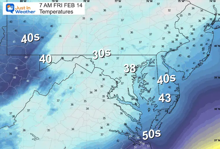
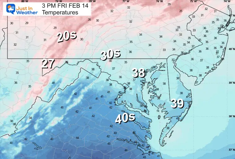
FRIDAY WEATHER: Valentine’s Day
Just a dry day with cooler air flowing in.
Morning Temperatures
Afternoon Temperatures
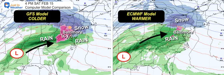
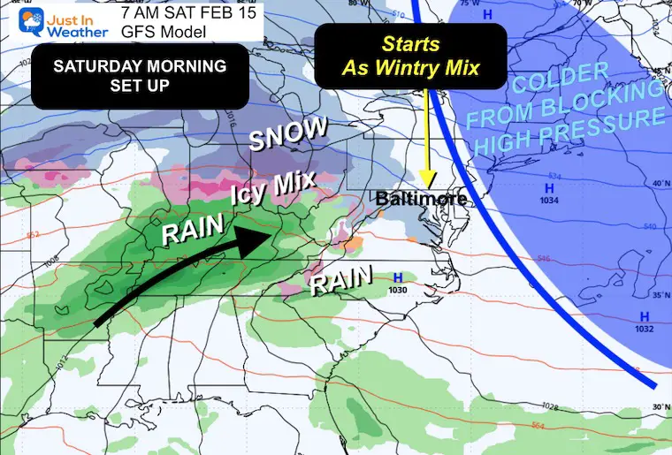
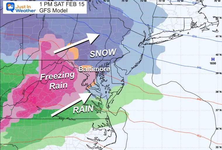
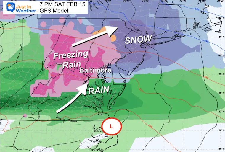
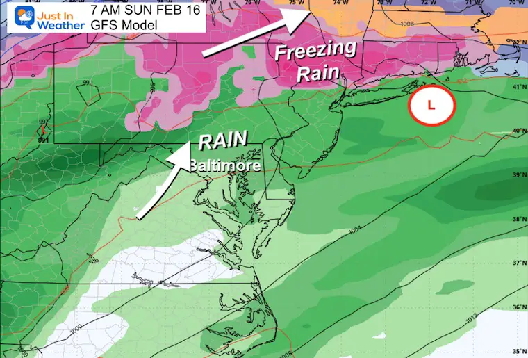
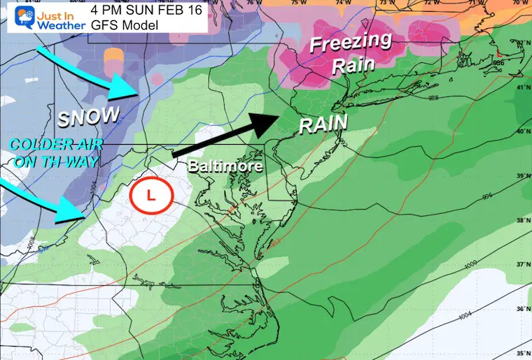
Weekend Storm:
Comparison Saturday Afternoon
Here, the GFS Model remains colder with a more wintry mix. There is support that it could be handling this earlier event better… But the Euro may be better next week (see below).
BOTH bring warmer rain later Saturday into Sunday. Rain may be heavy, and the Polar Air will arrive at the end of the event by Sunday night.
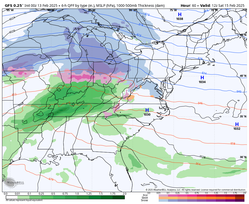
GFS Model Forecast
Set Up:
Cold air blocking in New England is the reason the cold will hold and start with snow and ice on Saturday morning.
Forecast: Saturday Morning to Sunday Night
Snapshots:
Saturday Afternoon
Saturday Evening
Sunday Morning
Sunday Afternoon
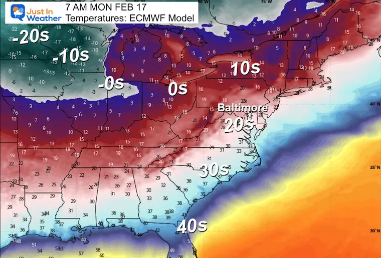
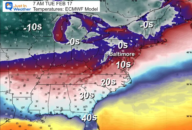
Polar Air Early Next Week
The influence of the Polar Vortex will send deep arctic air into the US, Well Below Zero across the Northern Plains.
The arrival into our region may be a little later… This may play a role in the next storm next week.
Monday Morning
Tuesday Morning
Next Week Storm?
This is still uncertain because it is more than 1 week away. As of now, the model split for Wednesday to Thursday:
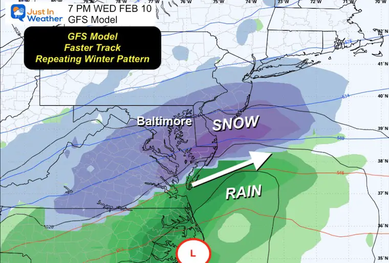
The GFS Model is faster and follows a similar track to what we just saw… Favors more snow south.
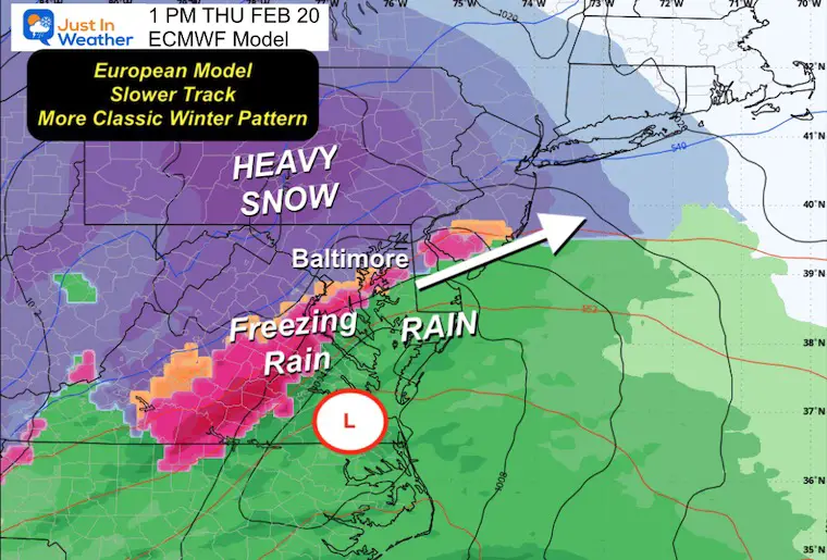
The European Model shows a more classic winter storm with close Low Pressure, an icy mix near I-95, and heavier snow inland.
GFS Model
European Model
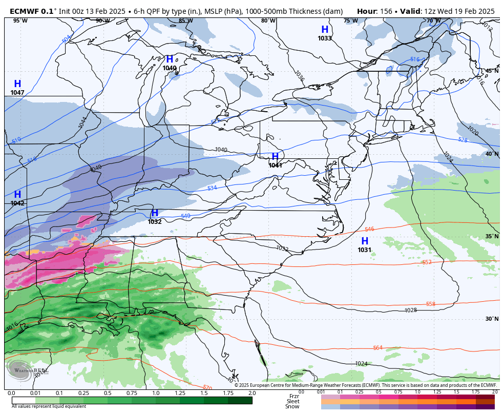
Forecast Simulation: Wednesday Morning to Friday Morning
Here is the European Solution. This model gets the edge farther out in time.
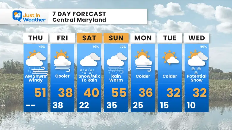
7 Day Forecast
WEEKEND: Watching Saturday mix to Rain
Polar Air arrives on Monday
Keeping the winter storm potential open between Wednesday and Thursday
Subscribe for eMail Alerts
La Nina Advisory January 2025
Full Report

MY WINTER OUTLOOK
My Winter Outlook Report

ALSO SEE
Recent Snow Reports
SNOW REPORTS THIS SEASON
Click on the maps for that full report.
January 19 Snow Report

January 11 Snow Report

January 6 Snow Report

Previous Snow

FITF Gear on Sale

In Case You Missed This
The Faith In The Flakes Dec 5 Origin Story

Please share your thoughts and best weather pics/videos, or just keep in touch via social media.
SCHEDULE A WEATHER BASED STEM ASSEMBLY
Severe Weather: Storm Smart October and next spring Winter Weather FITF (Faith in the Flakes): November To March Click to see more and send a request for your school.

THANK YOU:
Baltimore Magazine Readers Choice Best Of Baltimore
Maryland Trek 11 Day 7 Completed Sat August 10
We raised OVER $104,000 for Just In Power Kids – AND Still Collecting More
The annual event: Hiking and biking 329 miles in 7 days between The Summit of Wisp to Ocean City.
Each day, we honor a kid and their family’s cancer journey.
Fundraising is for Just In Power Kids: Funding Free Holistic Programs. I never have and never will take a penny. It is all for our nonprofit to operate.
Click here or the image to donate:

RESTATING MY MESSAGE ABOUT DYSLEXIA
I am aware there are some spelling and grammar typos and occasional other glitches. I take responsibility for my mistakes and even the computer glitches I may miss. I have made a few public statements over the years, but if you are new here, you may have missed it: I have dyslexia and found out during my second year at Cornell University. It didn’t stop me from getting my meteorology degree and being the first to get the AMS CBM in the Baltimore/Washington region. One of my professors told me that I had made it that far without knowing and to not let it be a crutch going forward. That was Mark Wysocki, and he was absolutely correct! I do miss my mistakes in my own proofreading. The autocorrect spell check on my computer sometimes does an injustice to make it worse. I also can make mistakes in forecasting. No one is perfect at predicting the future. All of the maps and information are accurate. The ‘wordy’ stuff can get sticky. There has been no editor who can check my work while writing and to have it ready to send out in a newsworthy timeline. Barbara Werner is a member of the web team that helps me maintain this site. She has taken it upon herself to edit typos when she is available. That could be AFTER you read this. I accept this and perhaps proves what you read is really from me… It’s part of my charm. #FITF


