Wednesday February 12 2025
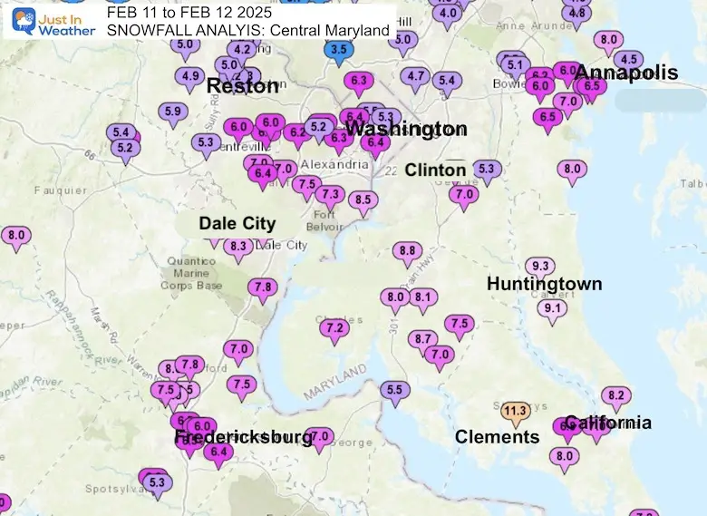
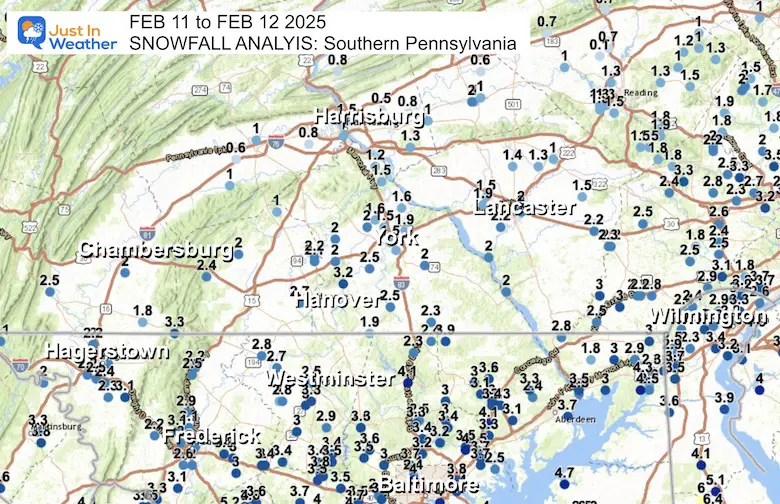
In the middle of a very active series of winter weather events, February 11 brought one of the largest snow storms of the season. Storm may be arbitrary depending on where you are located. The snowfall matched our January 6 storm where more fell on the southern part of our area, with the north edge of those higher snow totals reaching Washington and Annapolis.
Major Weather Stations Reports
- Baltimore at BWI: Storm = 3.8” ; Season 12.7” (0.3” above average to date)
- Washington at National = 6.4”
- Washington at Dulles = 4.8”
My goal in forecast and checklist for snow storms is pretty simple:
- Did you get what was expected?
- Did the snow arrive on time?
- Did the totals match up to my snow forecast map?
I want to keep this report simple. Below are maps comparing my forecast to observation maps. I have a list of snow reports only for Maryland West of the Bay and Southern PA due to limited space. I hope you find your nearby location listed on the maps.
NOTES:
We are in a complex region with a large population long Interstate 95 the has the Chesapeake Bay and Atlantic Ocean to the east. To the north and west are higher hills and all mountains along the Piedmont of the Appalachian Mountains.
GRADE: A
I will gladly take my wins after knowing they all do not work out this well.
In my opinion, this storm worked out as well as I could have expected. This report is to compare my call to the results. If you would like to chime in, please share your thoughts on the social media post where you may have seen this. If not, go here on my Facebook page or X Feed.
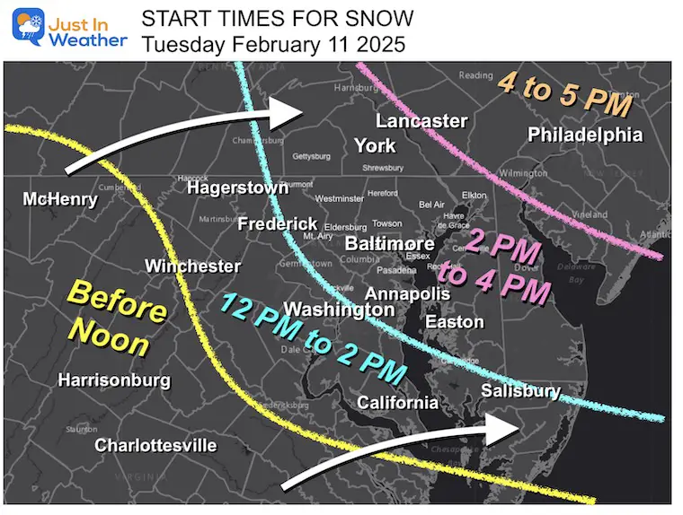
First Flakes
My forecast from Monday for the snow to being on Tuesday mid day through the afternoon.
My Forecast
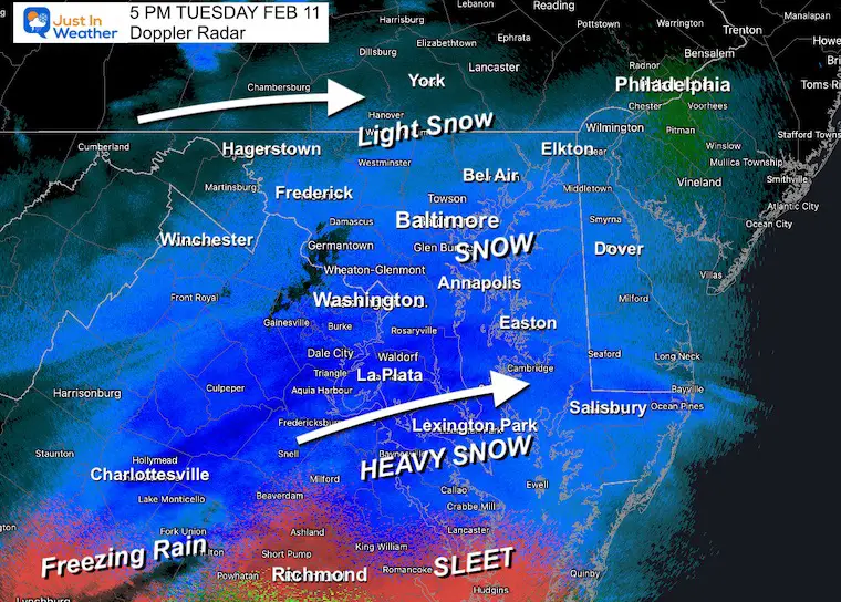
Doppler Radar at 5 PM
This was very close to perfect. I did write earlier in the day that this may arrive on the back end of my timeline, but for the most part this hit! They delay was in Pennsylvania between Lancaster and Philadelphia.
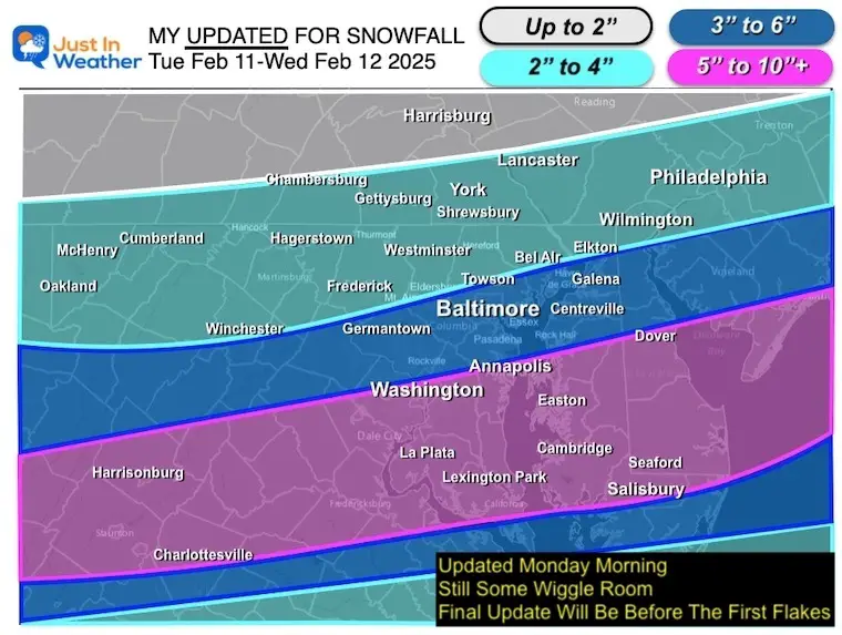
Snowfall Totals
Many more local maps are posted below. This is to compare a similar map view to my forecast.
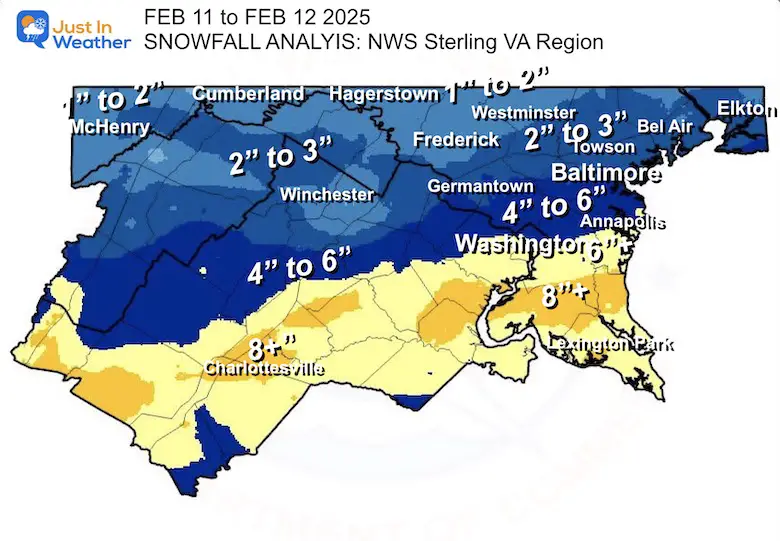
NOAA Snow Analysis
I added the text to try and match some colors in my zones.

My Call For Snowfall From Monday Morning
Note: I made one more adjustment on Tuesday only to add the mention of sleet and rain mixing in across Southern Maryland.
Closer Maps
The National Weather Service Region for the Baltimore Washington Office located in Sterling VA
Central Maryland

Southern Maryland
Delmarva

Southern Pennsylvania
SNOW SPOTTER REPORTS
…District of Columbia…
- Adams Morgan 1 SSE 5.5 830 AM 2/12 Trained Spotter
- Washington 1 E 5.3 700 AM 2/12 Trained Spotter
MARYLAND
…Allegany County…
- Potomac Park 2 NW 3.3 800 AM 2/12 Dept of Highways
- Ridgeley 1 NW 3.0 834 AM 2/12 Trained Spotter
- Frostburg 2 ENE 2.5 1010 AM 2/12 Trained Spotter
- Bellegrove 1 SSE 1.5 745 AM 2/12 Trained Spotter
…Anne Arundel County…
- Cape St. Claire 8.0 552 AM 2/12 Trained Spotter
- Churchton ENE 8.0 700 AM 2/12 Trained Spotter
- Londontowne 1 SSE 7.0 739 AM 2/12 NWS Employee
- Londontowne 3 SW 6.5 707 AM 2/12 CoCoRaHS
- Annapolis 1 S 6.5 800 AM 2/12 Trained Spotter
- Eastport 1 SSW 6.5 730 AM 2/12 Trained Spotter
- Crownsville 3 SSW 6.2 700 AM 2/12 Trained Spotter
- Parole 6.0 800 AM 2/12 Dept of Highways
- Riva 2 WNW 6.0 800 AM 2/12 Trained Spotter
- Crofton 2 NNE 5.5 700 AM 2/12 NWS Employee
- Crofton 1 SSE 5.1 817 AM 2/12 NWS Employee
- Chelsea Beach 4.8 315 AM 2/12 Trained Spotter
- Cape St. Claire 3 SE 4.5 800 AM 2/12 Dept of Highways
- Baltmore-Washington 4.0 800 AM 2/12 Dept of Highways
- Green Haven 1 ESE 4.0 600 AM 2/12 Trained Spotter
- Bwi Airport 3.8 700 AM 2/12 Official NWS Obs
…Baltimore County…
- Edgemere SE 4.9 730 AM 2/12 Trained Spotter
- Bentley Springs 6 S 4.1 800 AM 2/12 Dept of Highways
- North Point State Pa 4.0 645 AM 2/12 Trained Spotter
- Rosedale 1 E 3.8 800 AM 2/12 Dept of Highways
- Owings Mills 3.6 800 AM 2/12 Dept of Highways
- Randallstown 2 NW 3.5 914 AM 2/12 Trained Spotter
- Perry Hall 1 NNE 3.5 758 AM 2/12 Trained Spotter
- Fullerton 1 N 3.5 900 AM 2/12 Trained Spotter
- Timonium 3.4 213 AM 2/12 Public
- Glyndon 1 WSW 3.3 451 AM 2/12 Trained Spotter
- Upper Falls 1 NNE 3.3 530 AM 2/12 Trained Spotter
- Hampton 1 NE 3.2 729 AM 2/12 Public
- Long Green 2 NW 3.0 600 AM 2/12 Trained Spotter
- Cockeysville 1 N 2.5 113 AM 2/12 Broadcast Media
- Bentley Springs 1 E 2.3 600 AM 2/12 Trained Spotter
…Baltimore City…
- Fells Point 4.0 800 AM 2/12 Dept of Highways
- Arlington 2 E 4.0 257 AM 2/12 Broadcast Media
…Calvert County…
- Huntingtown SW 9.3 650 AM 2/12 Trained Spotter
- Prince Frederick 1 S 9.1 430 AM 2/12 Trained Spotter
- Dowell 2 NE 8.2 630 AM 2/12 Trained Spotter
…Carroll County…
- Carrolltowne 1 S 3.5 800 AM 2/12 Trained Spotter
- Eldersburg 1 SE 3.4 500 AM 2/12 Trained Spotter
- Sykesville 1 NNW 3.4 841 AM 2/12 NWS Employee
- Watersville 1 N 3.4 726 AM 2/12 Trained Spotter
- Westminster 3 S 3.3 900 AM 2/12 Trained Spotter
- Winfield 1 N 3.0 645 AM 2/12 Trained Spotter
- Gamber 1 WNW 2.9 1015 AM 2/12 CoCoRaHS
- Taneytown NE 2.8 930 AM 2/12 Trained Spotter
- Uniontown 3 N 2.7 604 AM 2/12 Trained Spotter
- Westminster 1 NNE 2.5 800 AM 2/12 Dept of Highways
- Millers 4 NE 1.9 1223 AM 2/12 Co-Op Observer
…Cecil County…
- Elkton 2 W 4.3 800 AM 2/12 Dept of Highways
- Elkton 4 SW 4.0 700 AM 2/12 Trained Spotter
- Perryville 1 SW 3.5 800 AM 2/12 Dept of Highways
- Pleasant Hill 2 SSE 2.9 700 AM 2/12 Trained Spotter
- Rock Springs 1 ESE 2.8 835 AM 2/12 Trained Spotter
- Perryville 1 SSW 2.5 700 AM 2/12 Trained Spotter
…Charles County…
- Waldorf 2 W 8.8 610 AM 2/12 Trained Spotter
- Dentsville 1 SW 8.7 130 AM 2/12 Trained Spotter
- La Plata 3 E 8.1 646 AM 2/12 Public
- La Plata 2 NNW 8.0 800 AM 2/12 Dept of Highways
- Charlotte Hall 2 NW 7.5 600 AM 2/12 Trained Spotter
- Welcome 2 WNW 7.2 700 AM 2/12 Trained Spotter
- Wicomico 2 N 7.0 720 AM 2/12 Public
- Dahlgren 5 ENE 5.5 800 AM 2/12 Dept of Highways
…Frederick County…
- New Market 2 NW 3.3 800 AM 2/12 Trained Spotter
- Point of Rocks 1 NE 3.3 630 AM 2/12 Trained Spotter
- Adamstown 1 ESE 3.1 700 AM 2/12 NWS Employee
- Bloomfield 2 WSW 3.1 600 AM 2/12 NWS Employee
- Mount Airy 1 WSW 3.0 929 AM 2/12 Trained Spotter
- Green Valley 1 WNW 3.0 600 AM 2/12 Trained Spotter
- New Market N 3.0 730 AM 2/12 Trained Spotter
- Lewistown 2 SSW 2.9 800 AM 2/12 Trained Spotter
- Ballenger Creek WSW 2.6 630 AM 2/12 Trained Spotter
- Frederick 1 SE 2.3 825 AM 2/12 Trained Spotter
- Thurmont 1 NE 2.2 648 AM 2/12 Trained Spotter
- Frederick 2 W 2.0 700 AM 2/12 Trained Spotter
- Ballenger Creek 1 E 2.0 800 AM 2/12 Dept of Highways
…Garrett County…
- Grantsville 5 W 3.8 800 AM 2/12 Dept of Highways
- Deer Park 6 NE 3.0 1000 AM 2/12 Trained Spotter
- Accident 4 E 2.9 700 AM 2/12 Public
- Oakland 5 NW 2.5 745 AM 2/12 Trained Spotter
…Harford County…
- Aberdeen Proving Gro 3.7 324 AM 2/12 Trained Spotter
- Forest Hill 1 NNW 3.6 915 AM 2/12 Trained Spotter
- Bel Air 2 W 3.4 700 AM 2/12 Trained Spotter
- Bel Air 3.4 829 AM 2/12 Other Federal
- Churchville 1 N 3.3 240 AM 2/12 Trained Spotter
- Chrome Hill 2 SE 3.2 617 AM 2/12 Trained Spotter
- Abingdon 2 NW 3.1 818 AM 2/12 Trained Spotter
- Forest Hill 3 SW 3.1 725 AM 2/12 Trained Spotter
- Churchville 1 SE 2.4 800 AM 2/12 Dept of Highways
…Howard County…
- Simpsonville 1 SSE 5.2 900 AM 2/12 Trained Spotter
- Simpsonville E 5.0 130 AM 2/12 Trained Spotter
- Columbia 4.8 700 AM 2/12 NWS Employee
- Laurel 3 NNE 4.8 713 AM 2/12 Trained Spotter
- Savage 1 ESE 4.4 900 AM 2/12 Trained Spotter
- Elkridge 2 W 4.4 600 AM 2/12 Trained Spotter
- Elkridge 4.1 826 AM 2/12 NWS Employee
- Dayton 1 NE 4.0 800 AM 2/12 Dept of Highways
- Laurel 2 N 4.0 100 AM 2/12 Trained Spotter
- Sykesville 2 SSE 3.8 630 AM 2/12 Trained Spotter
- Ellicott City 1 SW 3.7 820 AM 2/12 Trained Spotter
- Gaither 2 SSE 3.5 716 AM 2/12 Trained Spotter
- Ellicott City 3.5 1045 AM 2/12 Broadcast Media
- Columbia 1 ENE 3.0 400 AM 2/12 Trained Spotter
- Oella 2 NNE 2.5 1210 AM 2/12 Trained Spotter
…Montgomery County…
- Somerset 1 ENE 6.3 814 AM 2/12 Trained Spotter
- Clarksburg 5.2 746 AM 2/12 Emergency Mngr
- Clarksburg 2 SE 5.2 720 AM 2/12 Public
- Wheaton 1 NW 5.1 1200 AM 2/12 Trained Spotter
- Calverton 1 SW 5.0 800 AM 2/12 Dept of Highways
- Gaithersburg 5.0 800 AM 2/12 Dept of Highways
- Rockville 4.9 434 AM 2/12 Public
- Washington Grove 1 N 4.6 1050 AM 2/12 Trained Spotter
- Aspen Hill 1 SW 4.5 815 AM 2/12 Trained Spotter
- Norbeck 1 ESE 4.4 700 AM 2/12 Trained Spotter
- Washington Grove 1 N 4.4 802 AM 2/12 Trained Spotter
- Olney 4.1 725 AM 2/12 Newspaper
- Damascus 3 SSW 4.0 640 AM 2/12 Co-Op Observer
- Gaithersburg 2 E 3.8 817 AM 2/12 NWS Employee
- Gaithersburg 1 SW 3.7 616 AM 2/12 Trained Spotter
- Damascus 1 SE 3.6 700 AM 2/12 Trained Spotter
- Boyds 1 SE 3.6 930 AM 2/12 Trained Spotter
- Garrett Park 1 WSW 3.5 827 AM 2/12 Trained Spotter
- Laytonsville 2 WNW 3.4 630 AM 2/12 Trained Spotter
…Prince Georges County…
- Andrews Afb 2 E 7.8 900 AM 2/12 Trained Spotter
- Marlton 1 WSW 7.0 730 AM 2/12 Trained Spotter
- New Carrollton 1 E 5.4 131 AM 2/12 Public
- Upper Marlboro 1 S 5.3 800 AM 2/12 Dept of Highways
- College Park 1 S 4.7 900 AM 2/12 Trained Spotter
- Laurel 1 E 4.0 800 AM 2/12 Dept of Highways
…St. Marys County…
- Clements 3 E 11.3 800 AM 2/12 Dept of Highways
- Callaway 2 W 8.0 345 AM 2/12 Trained Spotter
- Ridge 1 ENE 7.2 700 AM 2/12 Trained Spotter
- California 3 W 6.8 745 AM 2/12 Trained Spotter
…Washington County…
- Sabillasville 2 NNW 3.3 1014 AM 2/12 CoCoRaHS
- Boonsboro 3 NNE 3.1 930 AM 2/12 Trained Spotter
- Funkstown 2 WSW 2.5 800 AM 2/12 Dept of Highways
- Fairplay 3 ENE 2.3 815 AM 2/12 Trained Spotter
- Pecktonville 3 NNW 2.1 711 AM 2/12 NWS Employee
- Maugansville WSW 2.0 700 AM 2/12 Trained Spotter
- Hancock 1 ESE 2.0 730 AM 2/12 Trained Spotter
Pennsylvania
Lancaster County…
- Gap 0.3 NW 2.2 in
- Lancaster 2.0 in
- Holtwood 2.0 in
- 1 E Lancaster 2.0 in
- Safe Harbor 2.0 in
- Lancaster 5.8 WNW 1.9 in
- 2.1 SE New Holland 1.5 in
- Landisville 1.2 ESE 1.5 in
- Lititz 0.3 WNW 1.4 in
- 4 E Wakefield 1.3 in
- 1 WSW Akron 1.3 in
- Ephrata 0.9 E 1.0 in
York County…
- 2 SW Spring Grove 3.2 in
- 1 S New Salem 2.5 in
- Stewartstown 0.5 S 2.3 in
- Dover 2.2 E 2.0 in
- East Berlin 3.4 ESE 2.0 in
- Dover 4.2 WSW 2.0 in
- Red Lion 2.0 in
- York 3.4 NE 1.9 in
- Mount Wolf 1.0 SE 1.6 in
- York 1.5 in
- York 2.5 NNW 1.5 in
- York Haven 2.3 WNW 1.5 in
- Valley Green 0.8 ENE 1.2 in
- 2 SE York 1.0 in
.Adams County…
- Cashtown 1 S 2.4 in
- Abbottstown 2.4 N 2.2 in
- 1 SW Cashtown 2.1 in
- Abbottstown 2.0 N 2.1 in
- Biglerville 2.0 in
- York Springs 2.5 N 1.0 in
Subscribe for eMail Alerts
La Nina Advisory January 2025
Full Report

MY WINTER OUTLOOK
My Winter Outlook Report

ALSO SEE
Recent Snow Reports
SNOW REPORTS THIS SEASON
Click on the maps for that full report.
January 19 Snow Report

January 11 Snow Report

January 6 Snow Report

Previous Snow

FITF Gear on Sale

In Case You Missed This
The Faith In The Flakes Dec 5 Origin Story

Please share your thoughts and best weather pics/videos, or just keep in touch via social media.
SCHEDULE A WEATHER BASED STEM ASSEMBLY
Severe Weather: Storm Smart October and next spring Winter Weather FITF (Faith in the Flakes): November To March Click to see more and send a request for your school.

THANK YOU:
Baltimore Magazine Readers Choice Best Of Baltimore
Maryland Trek 11 Day 7 Completed Sat August 10
We raised OVER $104,000 for Just In Power Kids – AND Still Collecting More
The annual event: Hiking and biking 329 miles in 7 days between The Summit of Wisp to Ocean City.
Each day, we honor a kid and their family’s cancer journey.
Fundraising is for Just In Power Kids: Funding Free Holistic Programs. I never have and never will take a penny. It is all for our nonprofit to operate.
Click here or the image to donate:

RESTATING MY MESSAGE ABOUT DYSLEXIA
I am aware there are some spelling and grammar typos and occasional other glitches. I take responsibility for my mistakes and even the computer glitches I may miss. I have made a few public statements over the years, but if you are new here, you may have missed it: I have dyslexia and found out during my second year at Cornell University. It didn’t stop me from getting my meteorology degree and being the first to get the AMS CBM in the Baltimore/Washington region. One of my professors told me that I had made it that far without knowing and to not let it be a crutch going forward. That was Mark Wysocki, and he was absolutely correct! I do miss my mistakes in my own proofreading. The autocorrect spell check on my computer sometimes does an injustice to make it worse. I also can make mistakes in forecasting. No one is perfect at predicting the future. All of the maps and information are accurate. The ‘wordy’ stuff can get sticky. There has been no editor who can check my work while writing and to have it ready to send out in a newsworthy timeline. Barbara Werner is a member of the web team that helps me maintain this site. She has taken it upon herself to edit typos when she is available. That could be AFTER you read this. I accept this and perhaps proves what you read is really from me… It’s part of my charm. #FITF


